Kabugao, Apayao
| Kabugao | |
|---|---|
| Municipality | |
|
Landscape in barangay Dibagat | |
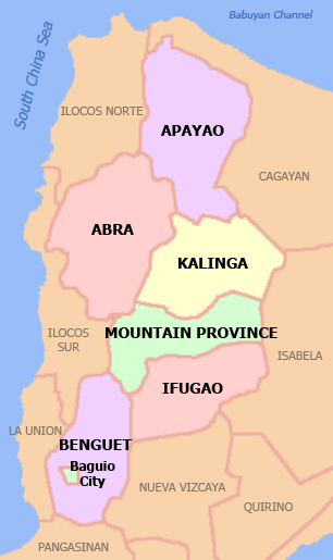
 Location in the province of Apayao | |
.svg.png) Kabugao Location within the Philippines | |
| Coordinates: 17°50′N 121°16′E / 17.83°N 121.27°ECoordinates: 17°50′N 121°16′E / 17.83°N 121.27°E | |
| Country | Philippines |
| Region | Cordillera Administrative Region (CAR) |
| Province | Apayao |
| District | Lone District |
| Founded | 1950 |
| Barangays | 21 (see Barangays) |
| Government [1] | |
| • Type | Sangguniang Bayan |
| • Mayor | Joseph C. Amid |
| Area[2] | |
| • Total | 935.12 km2 (361.05 sq mi) |
| Population (2015 census)[3] | |
| • Total | 15,537 |
| • Density | 17/km2 (43/sq mi) |
| • Voter (2016)[4] | 9,998 |
| Time zone | PST (UTC+8) |
| ZIP code | 3809 |
| IDD : area code | +63 (0)74 |
| Income class | 1st class |
| PSGC | 148104000 |

Kabugao, officially the Municipality of Kabugao (Filipino: Bayan ng Kabugao), is a municipality in the province of Apayao in the Cordillera Administrative Region (CAR) of the Philippines, serving as the provincial capital. The population was 15,537 at the 2015 census.[3] In the 2016 election, it had 9,998 registered voters.[4]
Geography
Kabugao is located at 17°50′N 121°16′E / 17.83°N 121.27°E.
According to the Philippine Statistics Authority, the municipality has a land area of 935.12 square kilometres (361.05 sq mi)[2] constituting 21.19% of the 4,413.35-square-kilometre- (1,704.00 sq mi) total area of Apayao.
Barangays
Kabugao is politically subdivided into 21 barangays.[5]
| PSGC | Barangay | Population | ±% p.a. | ||
|---|---|---|---|---|---|
| 2015[3] | 2010[6] | ||||
| 148104001 | Badduat | 6.1% | 943 | 1,000 | −1.11% |
| 148104002 | Baliwanan | 3.1% | 480 | 478 | +0.08% |
| 148104004 | Bulu | 1.9% | 297 | 298 | −0.06% |
| 148104007 | Cabetayan | 3.9% | 613 | 556 | +1.88% |
| 148104005 | Dagara | 3.5% | 541 | 484 | +2.14% |
| 148104006 | Dibagat | 4.5% | 704 | 797 | −2.33% |
| 148104008 | Karagawan | 4.2% | 655 | 676 | −0.60% |
| 148104009 | Kumao | 3.7% | 570 | 557 | +0.44% |
| 148104010 | Laco | 2.6% | 411 | 410 | +0.05% |
| 148104011 | Lenneng (Liyyeng) | 16.4% | 2,541 | 2,396 | +1.13% |
| 148104012 | Lucab | 3.9% | 604 | 660 | −1.67% |
| 148104013 | Luttuacan | 6.7% | 1,042 | 786 | +5.51% |
| 148104014 | Madatag | 5.1% | 798 | 766 | +0.78% |
| 148104015 | Madduang | 3.0% | 467 | 423 | +1.90% |
| 148104016 | Magabta | 1.3% | 203 | 215 | −1.09% |
| 148104017 | Maragat | 2.9% | 453 | 503 | −1.97% |
| 148104018 | Musimut | 3.9% | 607 | 822 | −5.61% |
| 148104019 | Nagbabalayan | 3.1% | 482 | 511 | −1.11% |
| 148104020 | Poblacion | 16.9% | 2,629 | 3,217 | −3.77% |
| 148104021 | Tuyangan | 1.8% | 285 | 334 | −2.98% |
| 148104022 | Waga | 1.4% | 212 | 281 | −5.22% |
| Total | 15,537 | 16,170 | −0.76% | ||
Dibagat
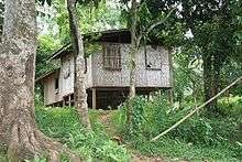
Dibagat is inhabited by the Isnag and the Ilocano. There is a small grass airstrip built by SIL in 1985. Dibagat is accessible only by canoe or by specialized aircraft.
Demographics
| Population census of Kabugao | |||||||||||||||||||||||||
|---|---|---|---|---|---|---|---|---|---|---|---|---|---|---|---|---|---|---|---|---|---|---|---|---|---|
|
| ||||||||||||||||||||||||
| Source: PSA[3][6][7] | |||||||||||||||||||||||||
In the 2015 census, Kabugao had a population of 15,537.[3] The population density was 17 inhabitants per square kilometre (44/sq mi).
In the 2016 election, it had 9,998 registered voters.[4]
References
- ↑ "Municipality". Quezon City, Philippines: Department of the Interior and Local Government. Retrieved 31 May 2013.
- 1 2 "Province: Apayao". PSGC Interactive. Makati City, Philippines: Philippine Statistics Authority. Retrieved 4 November 2016.
- 1 2 3 4 5 "CORDILLERA ADMINISTRATIVE REGION (CAR)". Census of Population (2015): Total Population by Province, City, Municipality and Barangay (Report). PSA. Retrieved 20 June 2016.
- 1 2 3 "2016 National and Local Elections Statistics". Commission on Elections. 2016.
- ↑ "Municipal: Kabugao, Apayao". PSA. Philippines: National Statistical Coordination Board. Retrieved 8 January 2016.
- 1 2 "CORDILLERA ADMINISTRATIVE REGION (CAR)". Census of Population and Housing (2010): Total Population by Province, City, Municipality and Barangay (Report). NSO. Retrieved 29 June 2016.
- ↑ "CORDILLERA ADMINISTRATIVE REGION (CAR)". Census of Population (1995, 2000 and 2007): Total Population by Province, City and Municipality (Report). NSO. Archived from the original on 24 June 2011.
External links
| Wikimedia Commons has media related to Kabugao, Apayao. |
 |
Calanasan | Luna | Pudtol | |
| |
Flora Santo Niño, Cagayan | |||
| ||||
| | ||||
| Tineg, Abra | Conner | Rizal, Cagayan |