Kabankalan
- Not to be confused with Barangay Cabancalan in Mandaue City, Cebu
| Kabankalan | ||
|---|---|---|
| Component City | ||
| City of Kabankalan Lungsod ng Kabankalan (Tagalog) Dakbanwa/Syudad sang Kabankalan (Hiligaynon) | ||
|
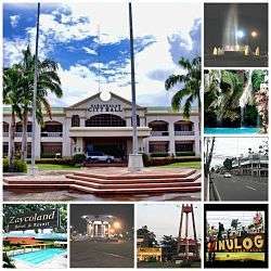
Kabankalan City, Negros Occidental – Montage | ||
| ||
| Nickname(s): The Rising City of the South, Regional Center of Negros Island Region | ||
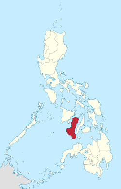
 Map of Negros Occidental with Kabankalan highlighted | ||
.svg.png) Kabankalan Location within the Philippines | ||
| Coordinates: 09°59′N 122°49′E / 9.983°N 122.817°ECoordinates: 09°59′N 122°49′E / 9.983°N 122.817°E | ||
| Country |
| |
| Region | Negros Island Region (NIR/Region XVIII) | |
| Province | Negros Occidental | |
| Congr. district | 6th District of Negros Occidental | |
| Incorporated | March 14, 1907 (town) | |
| Incorporated | August 2, 1997 (city) | |
| Barangays | 32 | |
| Government[1] | ||
| • Mayor | Isidro P. Zayco | |
| • Vice Mayor | Raul C. Rivera | |
| Area[2] | ||
| • Total | 697.35 km2 (269.25 sq mi) | |
| Population (2015)[3] | ||
| • Total | 181,977 | |
| • Density | 260/km2 (680/sq mi) | |
| Time zone | PST (UTC+8) | |
| ZIP code | 6111 | |
| Dialing code | 034 | |
| Income class | 1st class | |
| Languages | Hiligaynon (Ilonggo), Filipino, English | |
| Website |
www | |
Kabankalan, officially the City of Kabankalan and often simply referred to as Kabankalan City, is a first class city in the province of Negros Occidental, Philippines. According to the 2015 census, it has a population of about 181,977 people,[3] making it the second most populous city in the Negros Island Region next to Bacolod City. Kabankalan City is the 2nd wealthiest city of Negros Occidental next to Bacolod. In terms of land area, Kabankalan City is the second largest city in Visayas next to Bayawan City with a total area of 697.35 km2
Kabankalan is over an hour's drive south of Bacolod City by private car while public utility vehicles reach the place in about two hours. The city, which serves as the hub of economic activities in southern Negros, is also the take-off point for various destinations down south, and links the province to Dumaguete City, capital of Negros Oriental, via the Kabankalan-Mabinay Highway. Its location roughly halfway between Bacolod and Dumaguete made it to host the regional center of the Negros Island Region, along with neighbouring Mabinay to its southeast in Negros Oriental. Once completed, the Kabankalan City Domestic Airport will be the second active airport in the province (after the Bacolod-Silay International Airport).[4] Also located in the city is the main campus of the Central Philippines State University (CPSU).
The city hosts three major festivals: the Kabankalan Sinulog every third Sunday of January (celebrated together with Cebu City), Udyakan sa Kabankalan and the Charter Anniversary. Kabankalan is also known for its Mag-aso Falls and the Balicaocao Resort.
Kabankalan City won the major award as the "Best Performing City" in Region VI (the former region) in the 2011 Regional Search for Excellence in Local Governance (EXCEL). The award was given during the Pagdayaw 2011 program held at the Iloilo Grand Hotel in December 2011.[5]
Geography
Kabankalan occupies the central portion of the Southern Negros Island and its geographically located at 10° north and 122° east. It is bounded on the north by the City of Himamaylan, on the northwest by Panay Gulf, on the southwest by the Municipality of Ilog and on the southeast by the Province of Negros Oriental. It is 90 kilometers away from Bacolod City and 100 kilometers from Dumaguete City and the southern most town of Hinoba-an. With an area of 697.95 square kilometers, it is the largest city in Negros Occidental and the second largest in the whole Negros Island Region, after Bayawan City (which has an area of 699.08 square kilometers).
Climate
Kabankalan has Type 3 climate condition which means dry season is from December to May while the rainy season is from June to November. Average temperature is 26 degrees Celsius (80 degrees Fahrenheit).
Barangays
Kabankalan City is politically subdivided into 32 barangays.[2]
- Bantayan
- Binicuil
- Camansi
- Camingawan
- Camugao
- Carol-an
- Daan Banua
- Hilamonan
- Inapoy
- Linao
- Locotan
- Magballo
- Oringao
- Orong
- Pinaguinpinan
- Barangay 5 (Pob.)
- Barangay 6 (Pob.)
- Barangay 7 (Pob.)
- Barangay 8 (Pob.)
- Barangay 9 (Pob.)
- Barangay 1 (Pob.)
- Barangay 2 (Pob.)
- Barangay 3 (Pob.)
- Barangay 4 (Pob.)
- Salong
- Tabugon
- Tagoc
- Talubangi
- Tampalon
- Tan-Awan
- Tapi
- Tagukon
History
According to historians, the first inhabitants of Kabankalan were people who came from neighboring towns. They derived the name Kabankalan from the word “Bangkal” a specie of trees which is abundant in the place. The settlers established the Barangay form of government, which every group has its own leader called the Capitan.
In early years, Kabankalan started as a barrio of Ilog, a neighboring town of the city today. When Kabankalan turned into a town in 1903, its first town president was Capitan Lorenzo Zayco, but in mid-1907 a group of rebel called “pulahan” led by Papa Isio raided the town and burned all the houses. However, the people of Kabankalan quickly recovered and rebuilt the town from destruction caused by the dissidents.
During the Spanish regime, the people were taught by the Spanish with their language and introduced the Roman Catholic religion. When the Americans came they introduced the democratic form of government. During this time, a lot of improvements came through to the town and new modern techniques of farming were introduced by the Americans to the local farmers that give them good products.
After the American regime, another invader occupied the town of Kabankalan: the Japanese, and during this time, a recognized guerrilla unit and local troops of the Philippine Commonwealth Army military units was formed to oppose the foreign aggression and many people fled to the mountain to avoid the Japanese military abuse but when Americans returned in the island to aiding Filipino soldiers under the Commonwealth Army and Constabulary and the recognized guerrillas, they helped the people to be freed from the Japanese.
After the second World War, the town progressed and started to regain its economy. The establishment of two sugar mills in the 1960’s and early 70’s gave the town a boost into the list of the top improving towns of Negros.
The town of Kabankalan was declared by former president Fidel V. Ramos as a chartered city on August 2, 1997, under Republic Act No. 8297.
Demographics
| Population census of Kabankalan | ||
|---|---|---|
| Year | Pop. | ±% p.a. |
| 1990 | 127,000 | — |
| 1995 | 139,282 | +1.74% |
| 2000 | 149,769 | +1.57% |
| 2007 | 166,970 | +1.51% |
| 2010 | 167,666 | +0.15% |
| 2015 | 181,977 | +1.57% |
| Source: National Statistics Office[3][6] | ||
References
- ↑ "Cities". Quezon City, Philippines: Department of the Interior and Local Government. Retrieved 5 March 2013.
- 1 2 "Province: Negros Occidental". PSGC Interactive. Makati City, Philippines: National Statistical Coordination Board. Retrieved 5 March 2013.
- 1 2 3 "Total Population by Province, City, Municipality and Barangay: as of May 1, 2015" (PDF). 2015 Census of Population and Housing. National Statistics Office. Retrieved 5 March 2013.
- ↑ Bayoran, Gilbert (20 January 2014). "Zayco: Kabankalan airport work still on". The Daily Star. Retrieved 25 November 2015.
- ↑ Kabankalan City is best performing city in WVisayas - PIA
- ↑ "Province of Negros Occidental". Municipality Population Data. LWUA Research Division. Retrieved 19 August 2013.
External links
- Kabankalan City Official Website
- Philippine Standard Geographic Code
- Philippine Statistics Authority
- Philippine Census Information
- Local Governance Performance Management System
- Chasing Waterfalls: Mag-aso Falls
 |
Panay Gulf | Himamaylan |  | |
| Ilog | |
Ayungon, Negros Oriental | ||
| ||||
| | ||||
| Bayawan, Negros Oriental | Mabinay, Negros Oriental |


