Këlcyrë
| Këlcyrë | |
|---|---|
| Municipality | |
 | |
 Këlcyrë | |
| Coordinates: 40°18′47″N 20°11′31″E / 40.313°N 20.192°ECoordinates: 40°18′47″N 20°11′31″E / 40.313°N 20.192°E | |
| Country |
|
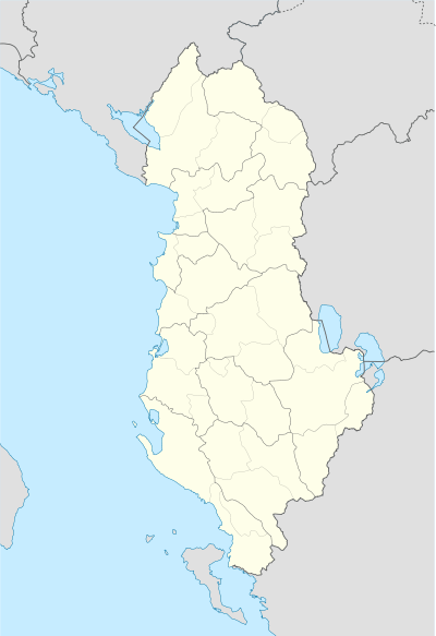
| County | Gjirokastër |
| Government | |
| • Mayor | Klement Ndoni (SP) |
| Area | |
| • Municipality | 304.65 km2 (117.63 sq mi) |
| Elevation | 176 m (577 ft) |
| Population (2011) | |
| • Municipality | 6,113 |
| • Municipality density | 20/km2 (52/sq mi) |
| • Administrative Unit | 2,651 |
| Time zone | CET (UTC+1) |
| • Summer (DST) | CEST (UTC+2) |
| Postal Code | 6402 |
| Area Code | (0)875 |
| Vehicle registration | AL |
Këlcyrë is a town and a municipality in southern Albania, located on the bank of the river Vjosë. It was formed at the 2015 local government reform by the merger of the former municipalities Ballaban, Dishnicë, Këlcyrë and Sukë, that became municipal units. The seat of the municipality is the town Këlcyrë.[1] The total population is 6,113 (2011 census), in a total area of 304.65 km2.[2] The population of the former municipality at the 2011 census was 2,651.[3] The municipal unit consists of the town Këlcyrë and the villages Fshat Këlcyrë, Mbrezhdan, Maleshovë, Limar, Leskaj and Kala.[4] The Vjosë forms a canyon near the town, known as the Këlcyrë Gorge.
Name
A medieval chronicle from the year 1272 mentioned the location with the Latin name Clausura (a word with meaning "close"[5]). The Byzantine Suda lexicon, writes that the Romans called the forts at the passes (Greek: Κλεισοῦραι).[6] During the Byzantine era the town was also called Klisura (Κλεισούρα).[7]
History
In antiquity the region was part of Epirus, and afterwards was incorporated into Upper Macedonia. Later it became part of the Roman empire.
During[8] the Second Macedonian War against the Romans, the troops of Phillip V and Athenagoras of Macedon attempted to delay the Roman consul, Titus Quinctius Flamininus. The Macedonians had secured the passage and then blocked the Roman advance in 198 BC. A shepherd is said to have led the Roman troops through the mountains, so that they could attack the Macedonians in the narrow gorge of two sides and destroy them. The Macedonians had been decisively defeated a first time. Later, the Romans used the route through the gorge of modern Këlcyrë and built a small settlement.
To control this passage, a castle was built in the 13th century. When the town was incorporated in the Kingdom of Albania in the late 13th century it was ruled by the Muzaka family. The correspondence of the Roman Curia with the Albanian nobility indicates that in 1319 it was ruled by Count Mentul Muzaka.[9] After its capture by the Byzantine army, the Albanian population rebelled against Byzantine rule in 1335 and captured the fortress of the town.[7][10]
The Turks advanced and built in the 19th century also a seraglio At this time Këlcyrë experienced its bloom as a key trading center between Berat, Korça and Gjirokastra.
The capture of Klisura Pass (6–11 January 1941) was one of the most important victories of the Greek Army during the Greek-Italian War.
Today
Even today, the road is the main access route through the gorge that connects Këlcyrë with Tepelenë and other centers of Albania. To the south, the road continues to Përmet in the capital district and then to Greece. The road leading to the north in the direction of Berat is paved only a few kilometers, and navigation over long distances is very difficult. Around Këlcyrë there are some age-old Eastern Orthodox churches.
Notable people
- Ali Këlcyra, politician
- Sejfulla Malëshova, writer and politician, founder of the Albanian League of Writers and Artists in 1945.
- Veli bej Këlcyra, signatory of the Albanian Declaration of Independence.
| Wikimedia Commons has media related to Këlcyrë. |
References
- ↑ Law nr. 115/2014
- ↑ Interactive map administrative territorial reform
- ↑ 2011 census results
- ↑ Greece – Albania Neighbourhood Programme
- ↑ A Latin Dictionary
- ↑ Suda,Entry; Κλεισούραι
- 1 2 The Late Medieval Balkans
- ↑ Dictionary of Greek and Roman Geography (1854), William Smith, LLD, ed.: "It was in this pass that Philip V., king of Macedonia, in vain attempted to arrest the progress of the Roman consul, T. Quinctius Flamininus, into Epirus. Philip was encamped with the main body of his forces on Mount Aeropus, and his general, Athenagoras, with the light troops on Mount Asnaus."
- ↑ Lala, Etleva; Gerhard Jaritz (2008). "Regnum Albaniae and the Papal Curia" (PDF). Central European University. p. 32. Retrieved 3 February 2011.
- ↑ Nicol, Donald M. (2010-02-11). The Despotate of Epiros 1267-1479: A Contribution to the History of Greece in the Middle Ages. Cambridge University Press. pp. 108–9. ISBN 978-0-521-13089-9. Retrieved 14 July 2011.
Municipalities in Albania are administrative divisions made up of local administrative units and their inclusive villages. | ||
| (61) |
|  |
Administrative Divisions of Gjirokastër County | ||
|---|---|---|
County Seat: Gjirokastër | ||
| Municipality of Dropull |  | |
| Municipality of Gjirokastër | ||
| Municipality of Këlcyrë | ||
| Municipality of Libohovë | ||
| Municipality of Memaliaj | ||
| Municipality of Përmet | ||
| Municipality of Tepelenë | ||
Subdivisions of Këlcyrë Municipality | ||
|---|---|---|
Municipal Seat: Këlcyrë | ||
| Administrative Unit of Ballaban |
|  |
| Administrative Unit of Dishnicë |
| |
| Administrative Unit of Këlcyrë |
| |
| Administrative Unit of Sukë |
| |