Julliberrie's Grave
 | |
 Location within Kent | |
| Coordinates | 51°14′26″N 0°58′30″E / 51.240479°N 0.974888°E |
|---|---|
| Type | Long barrow |
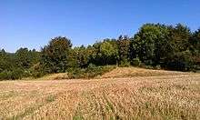
Julliberrie's Grave, also known as The Giant's Grave or The Grave, is an unchambered long barrow located near to the village of Chilham in the south-eastern English county of Kent. Constructed during Britain's Early Neolithic period, today it survives only in a ruined state.
Archaeologists have established that the monument was built by pastoralist communities shortly after the introduction of agriculture to Britain from continental Europe. Although representing part of an architectural tradition of long barrow building that was widespread across Neolithic Europe, Julliberrie's Grave belongs to a localised regional variant of barrows produced in the vicinity of the River Stour. Of these, it lies on the eastern side of the river, alongside the Shrub's Wood long barrow, while the third known example in this tumuli group, Jacket's Field long barrow, is located on the western side.
It is 44 metres (144 ft) in length, 2 metres (6 ft 7 in) high and measures 15 metres (49 ft) at its widest although it was originally longer. No evidence for any Early Neolithic human remains have been found at the site; it is possible that it never had any human remains placed within it, or that such burials were included in the (since destroyed) northern end of the barrow. A broken polished stone axe was included in the centre of the monument, which archaeologists believe was likely placed there as part of a ritual act of deposition. A rectangular pit was also dug into the western side of the barrow shortly after its completion, likely containing a ritual deposit of organic material, before being refilled.
In the Iron Age a hearth was established in the tumulus' ditch, while the long barrow witnessed extensive activity in Roman Britain, when it was used as the location for the burial of both human remains and a coin hoard. Ensuing millennia witnessed local folklore grow up around the site, associating it with the burial of either a giant or an army and their horses. The ruin attracted the interest of antiquarians in the 17th century, although around the 18th century, the northern end of the barrow was destroyed by chalk quarrying. During the 18th and 19th century, the barrow was dug into at least twice by antiquarians, while cautious archaeological excavation only took place in the 1930s. A Scheduled Ancient Monument, it is accessible to visitors all year around.
Location and status
Julliberrie's Grave is located on a shoulder of downland that flanks the eastern side of the River Stour.[1] Located just over half-a-mile southeast of Chilham Church,[1] Julliberrie's Grave can be inspected from an adjacent public path.[2] It is recognised as a Scheduled Ancient Monument under British law.[3]
Context
The Early Neolithic was a revolutionary period of British history. Beginning in the fifth millennium BCE, it saw a widespread change in lifestyle as the communities living in the British Isles adopted agriculture as their primary form of subsistence, abandoning the hunter-gatherer lifestyle that had characterised the preceding Mesolithic period.[4] Archaeologists have been unable to prove whether this adoption of farming was because of a new influx of migrants coming in from continental Europe or because the indigenous Mesolithic Britons came to adopt the agricultural practices of continental societies.[5] Either way, it certainly emerged through contact with continental Europe, probably as a result of centuries of interaction between Mesolithic people living in southeast Britain and Linear Pottery culture (LBK) communities in northeastern France.[6] The region of modern Kent would have been a key area for the arrival of continental European settlers and visitors, because of its position on the estuary of the River Thames and its proximity to the continent.[7]
Between 4500 and 3800 BCE, all of the British Isles came to abandon its former Mesolithic hunter-gatherer lifestyle, to be replaced by the new agricultural subsistence of the Neolithic Age.[8] It is apparent that although a common material culture was shared throughout most of the British Isles in this period, there was great regional variation regarding the nature and distribution of settlement, architectural styles, and the use of natural resources.[9] Throughout most of Britain, there is little evidence of cereal or permanent dwellings from this period, leading archaeologists to believe that the Early Neolithic economy on the island was largely pastoral, relying on herding cattle, with people living a nomadic or semi-nomadic way of life.[10] Archaeologists have no direct proof of gender relations on the island at this time, although most believe that it was probably a male-dominated society, in keeping with all recorded societies that practice large-scale animal husbandry.[11] There is archaeological evidence of violence and warfare in Early Neolithic Britain from such archaeological sites as West Kennet Long Barrow and Hambledon Hill, with some groups constructing fortifications to defend themselves from attackers.[12] Britain was largely forested in this period, although there was some land clearance.[13] It remains unclear to what extent the Kentish area was deforested in the Early Neolithic, although it appears that widespread forest clearance only took place on the chalklands of southeast Britain much later, in the Late Bronze Age.[14]
Tomb building tradition
Across Western Europe, the Early Neolithic marked the first period in which humans built monumental structures in the landscape.[15] These were tombs that held the physical remains of the dead, and though sometimes constructed out of timber, many were built using large stones, now known as "megaliths".[11] Individuals were rarely buried alone in the Early Neolithic, instead being interned in collective burials with other members of their community.[16] The construction of these collective burial monumental tombs, both wooden and megalithic, began in continental Europe before being adopted in Britain in the first half of the fourth millennium BCE.[17]
"It seems that the role of ancestors in Neolithic society was much more important than in the world of the hunter-gatherer. Clans and forebears began to have symbolic importance to the settled farming communities of the Neolithic. Dead ancestors were celebrated through funerals, feasts and grave goods, and their carefully selected body-parts were housed in specially built monuments, often symbolising 'houses' of the dead ... The tombs provide the earliest and most tangible evidence of Neolithic people and their customs, and are some of the most impressive and aesthetically distinctive constructions of prehistoric Britain."
Archaeologist and prehistorian Caroline Malone, 2001.[16]
The Early Neolithic people of Britain placed far greater emphasis on the ritualised burial of the dead than their Mesolithic forebears had done.[16] Many archaeologists have suggested that this is because Early Neolithic people adhered to an ancestor cult that venerated the spirits of the dead, believing that they could intercede with the forces of nature for the benefit of their living descendants.[18] Given that other rites may have taken place around these monuments, historian Ronald Hutton termed them "tomb-shrines" to reflect their dual purpose.[19]
In Britain, these tombs were typically located on prominent hills and slopes overlooking the surrounding landscape, perhaps at the junction between different territories.[20] Archaeologist Caroline Malone noted that the tombs would have served as one of a variety of markers in the landscape that conveyed information on "territory, political allegiance, ownership, and ancestors."[21] Many archaeologists have subscribed to the idea that these tomb-shrines served as territorial markers between different tribal groups, although others have argued that such markers would be of little use to a nomadic herding society.[22] Instead it has been suggested that they represent markers along herding pathways.[23] Many archaeologists have suggested that the construction of such monuments reflects an attempt to stamp control and ownership over the land, thus representing a change in mindset brought about by Neolithicisation.[24] Others have suggested that these monuments were built on sites already deemed sacred by Mesolithic hunter-gatherers.[25]
Archaeologists have differentiated these Early Neolithic tombs into a variety of different architectural styles, each typically associated with a different region within the British Isles.[26] Passage graves, characterised by their narrow passage made of large stones and one or multiple burial chambers covered in earth or stone, were predominantly located in northern Britain and southern and central Ireland. Alternately, across northern Ireland and central Britain long chambered mounds predominated, while in the east and south-east of Britain, earthen long barrows represented the dominant architectural trend.[27] These earthen long barrows were typically constructed of timber because building stone was scarce in southern Britain; archaeologist Aubrey Burl argued that these timber tombs might have been "even more eye-catching" than their stone counterparts, perhaps consisting of "towering carved poles, flamboyantly painted", but that evidence of such sculptures has not survived.[26]
Stour Long-Barrows

Around twelve Neolithic long-barrows are known from the county of Kent.[3] The best known of these are the Medway Megaliths, all of which are found in the vicinity of the River Medway and each containing a stone burial chamber.[3] However, the use of stone as a building material sets these Medway Megaliths apart from Julliberrie's Grave and the Stour Long-Barrows.[28] The decision by the builders of these Stour Long-Barrows to avoid using stone as a building material was likely deliberate, for sarsens are naturally present in the local area and could have been obtained without too much trouble.[29]
The Stour tumuli have been recognised by archaeologists as a distinct group of earthen long-barrows.[30] The three mounds are located within eight kilometres of each other, high up on the North Downs between Canterbury and Ashford.[3] As of 1998, Julliberrie's Grave is the only one of the three Stour long-barrows to have been archaeologically excavated.[3]
Design and construction
Trapezoidal in shape, Julliberrie's Grave is oriented on a north-northwest to south-southeast orientation.[31] As of the mid-1930s, the barrow measured 144 feet long, with a width of 48 feet at its northern end and 42 feet at its southern end.[32] At its greatest height, the tumulus measured 7 feet at its highest point.[33] These dimensions are smaller than those of the tumulus in the past; a letter written by an antiquarian in 1703 reported that the barrow was over 180 feet in length and over 40 feet broad at its widest section.[34] It was apparently enclosed by a ditch encircling both the sides and the southern end, without any causeways in it; whether it once encircled the northern end too is unknown due the damage sustained by that end of the monument.[35] This use of a ditch encircling the monument without any breaks in it is akin to those found on some of the long barrows in Dorset and Hampshire.[36]
No primary burials of human remains have been found in the barrow.[2] This tumulus might therefore have been an example of a long barrow that did not contain a burial; several other such empty examples are known to have existed.[2] Conversely, it could have been that human remains were located in the northern end of the mound, which was later destroyed by chalk quarrying prior to any archaeological excavation taking place.[37] It is possible that the barrow's purpose was not funerary in intent, perhaps instead serving largely as a territorial marker.[38]
Located well into the original turf-core of the southern end of the barrow was a broken polished stone-axe, discovered during the 1937 excavation of the site.[39] Given both the high status prestige of such an item and its location deep inside the barrow, various archaeologists to have commented on the axe have deemed it likely that it had been deliberately deposited into the barrow as part of a ritual act.[40] The inclusion of an axe within the monument is not unique to Julliberrie's Grave; elsewhere in Britain, axes have been found deposited inside causewayed enclosures and chambered tombs, thus testifying to their ceremonial treatment during the Early Neolithic.[41] Piggott highlighted that such polished axes have also been found in the chambered tombs of the Netherlands, furthermore highlighting that the style of the axe found within Julliberrie's Grave was skin to that found in the Netherlands, northern Germany, and Scandinavia, thereby suggesting a link between this part of Kent and those regions during the Early Neolithic.[42] It has been suggested that the location of this axe reflects the existence of an axe cult that was present in both Kent and elsewhere during this period.[43]
On the western side of the mound, a rectangular pit had been dug which measured 15.5 feet from east to west and 7.75 feet from north to south, as well as to a depth of at least 5 feet below the surface of the mound. Apparently having been carefully dug, it had also been carefully filled in; at its bottom was a deposit of lumpy chalk along with organic material that could not be identified by archaeologists, but which likely represented the item originally placed within the pit.[44] Although no datable material was found within this pit, analysis of land mollusc shells recovered from both the top and the bottom of the pit suggested that the pit was broadly contemporary in date with the construction of the barrow itself.[44] The archaeologist responsible for excavating this pit, Ronald Jessup, therefore suggested that the "burial pit" was "likely to postdate the mound only by a short period" which may have contained "a ritual offering made at the completion of the barrow".[45]
Julliberrie's Grave has not been firmly dated,[46] and an understanding of its age relies upon circumstantial evidence.[47] However, both its U-shaped plan and its lack of burials are representative of a later form in the European long barrow tradition.[46] On the typological basis of the polished axe-head found within the barrow, the archaeologist Stuart Piggott suggested that the monument had been constructed at a late date within the Early Neolithic.[48]
Subsequent history
Iron Age and Romano-British history
Evidence for activity dating from the British Iron Age was also found on site in the form of a hearth located in the western ditch. The remains of two pots were found alongside this hearth; one was made from "friable reddish-brown ware with large flint grits" and the other from "sandy, brown fabric, smoothed on the inside and with a fine flint tempering".[49]
Just as Romano-British finds are commonly located in and around monuments from the Early Neolithic,[50] so too there was "more than [a] casual Romano-British interest" in Julliberrie's Grave.[36] A number of Romano-British burials – consisting of both inhumations and cremations – have been found just to the south of the long barrow.[51] That classified as 'Roman Burial I' by its excavators was an inhumation of a child aged between 5 and 7, lain on its back with its feet to the north-east. It had been buried with a bronze brooch used to pin a shroud, as well as a bronze bracelet on its right arm and both a pottery dish and a cup by its head, all artefacts dated to the middle of the first century CE.[52] 'Roman Burial II' contained a female skeleton that was aged as being around 17 at the time of death. She was positioned on her back with her feet facing westward. Interned with the grave were a dish and a cup, both also dated to the middle of the first century CE.[52] Between Burial I and II was an area of "greasy yellow chalk", which the excavators believed represented evidence of what had once been the burial of an infant.[52] 'Roman Burial III' contained six pottery vessels: a flagon, a butt-shaped beaker, two small cups, a dish, and a wide-mouthed bowl that contained the cremated remains of a human cranium, as well as parts of the thorax and the long bones of a young adult. The bowl was placed atop six contiguous cervical vertebrae and a severed hand.[53] The excavators believed that this was a particularly early example of inhumation burial in Roman Britain, as this form of burial only became widespread in the third century CE.[54]
A pot containing a hoard of Roman coins dating to the era of the Emperor Constantine was buried in the vicinity of the barrow, to be discovered in the nineteenth century.[55] During the 1930s excavations, eight Roman coin of late fourth-century date were found below the turf at the southern end of the barrow – perhaps having been dropped from the hoard when it was discovered[52] – while a Roman coin dating from the reign of the Emperor Magnus Maximus was found in ploughsoil.[49] On the south-eastern side of the monument had been a Romano-British hearth, which subsequently was use to deposit animal bones, oyster shells, a fragment of a glass cup, and pieces of pottery, including a piece of Samian ware, most of which dated to the first century CE, and then topped by several large chalk flints; this was interpreted by excavators as "a rubbish dump", with the stones perhaps having come from a collapsed memorial cairn associated with the nearby burials.[56] Excavation to the site's northwest corner also revealed some worn pieces of Romano-British pottery, including a piece from a second century Samian ware cup, which were located six inches below the surface of the turf.[49] Romano-British pottery sherds were also found in the upper level of the ditch around the barrow.[49]
Damage and dilapidation
At some point in the barrow's history, its northern end was destroyed by an encroaching chalk pit; by the mid-1930s, it was reported that this pit has "not been worked for the past century" and had been stabilised by the growth of vegetation, which was preventing any further erosion.[57] The northern end of the tumulus has also faced some damage from wastage, a result of rain water repeatedly dripping onto it from overhanging trees.[57] Along part of the barrow's western side, the tumulus has been damaged by ploughing.[57]
Etymology, folklore, and literature
By the early decades of the twentieth century, the archaeological site had come to be known as "Julliberrie's", "The Grave", and "The Giant's Grave" among those living in the local area.[58] The -berrie aspect of the site's name may have derived from the Old English word beorge, meaning barrow.[59]
During the 1930s, the idea that the barrow marked the grave of a giant was still found among the local population.[58] Another tale recorded at the time was that the tumulus marked the burial place of one hundred horses and one hundred men who had been killed in battle but who could not be fitted into the graveyard of Chilham Church.[58] Also in this period, a local man named Mr Read, who lived in the neighbouring mill, said that his father had forbade him from climbing the mound, as it was disrespectful to stand upon a grave.[58]
Julliberrie's Grave also appears in R. Austin Freeman's 1936 novel The Penrose Mystery.[1]
Antiquarian and archaeological investigation
Antiquarian descriptions
Unlike the other two Stour long-barrows, the existence of Julliberrie's Grave has been known for many centuries.[3] In the writings of William Camden, Julliberrie's Grave is presented as the burial place of Julius Laberius, one of the tribunes of the Roman general Julius Caesar, who Camden alleged died in battle against the Iron Age Britons while engaged in the second of Caesar's invasions of Britain, in 54 BCE.[60] According to Camden:
- Below this town [Chilham], is a green barrow, said to be the burying-place of one Jul-Laber many ages since; who, some will tell you, was a Giant, others a Witch. For my own part, imagining all along that there might be something of real Antiquity couch'd under that name, I am almost perswaded [sic] that Laberius Durus the Tribune, slain by the Britains [sic]... was buried here; and that from him the Barrow was call'd Jul-Laber.[59]
Camden's ideas were largely accepted by later antiquarian commentators on the site, among them William Lambarde in his 1576 Perambulation of Kent, Richard Kilburne in his 1650 A Topographie of Kent, and Philipott in this 1659 Villare Cantianum.[59]
Early investigations
An excavation of the barrow was carried out by Lord Weymouth and Heneage Finch, later the 5th Earl of Winchelsea, in 1702. Finch dug a shaft through the middle of the mound and then expanded it into a trench along the barrow's length in what was one of the earliest organised 'barrow openings' ever undertaken. He found a few bones he thought were from animals and described a core of dark earth within the barrow covered by a chalk cap.[34]
In 1722, the site was visited by the antiquarian William Stukeley, with him publishing his descriptions and three engravings of the barrow shortly after.[61] Surface evidence that a cross-trench was placed into the heart of the barrow has resulted in the suggestion that another excavation was carried out at some point, likely conducted by a member of the Wildman family who owned the Chilham Castle estate between 1792 and 1861.[57]
In the early 19th century, a fence was set up around the barrow by its owner to prevent trespassers walking onto it; this would be gone by the mid-1930s.[58] It was during the digging of a post hole for the fence that the hoard of Roman coins was discovered.[55] Although the site had long been recognised as a tumulus, it was only in 1868 that it was first recognised as a long barrow, by John Thurnam.[62] In 1880, the archaeologist Flinders Petrie recorded the site among a list of Kentish earthworks, referring to it as "Julaber's Grave".[63] It was then examined and recorded by the archaeologist O. G. S. Crawford in his 1924 Ordnance Survey, Professional Papers.[64]
Jessup's excavation
In July 1936, an excavation of the barrow was carried out under the directorship of the archaeologist Ronald Jessup.[1] The excavation was both instigated and funded by the landowner who owned the barrow, Edmund Davis.[1] After conducting this excavation, Jessup's team engaged in some conservation by filling in rabbit holes and removing thorn bushes that were causing damage to the barrow.[57] In 1937, Davis paid for Jessup to run a second excavation at the site. This time lasting for eight weeks, the "primary object" of this excavation was to gain good dating evidence for the creation of the tumulus, something that had not been obtained in the 1936 excavation.[65] The lithics discovered at the site were analysed by Grahame Clark,[66] while the pottery was examined by Stuart Piggott.[49] Jessup's investigation confirmed Thurnam's view that the tumulus was a Neolithic long barrow, also confirming that the northern end had been destroyed and discovering both the polished stone axe and the Romano-British burials.[62]
Characterising Jessup's excavation as "careful, [and] comprehensive",[43] Ashbee later related that Jessup's excavation was one of "a small series of long barrow excavations carried out" during the 1930s which "were the valued precedents" of those that would be carried out after the Second World War.[36]
References
Footnotes
- 1 2 3 4 5 Jessup 1937, p. 122.
- 1 2 3 Parfitt 1998, p. 16.
- 1 2 3 4 5 6 Parfitt 1998, p. 15.
- ↑ Hutton 1991, p. 16.
- ↑ Hutton 1991, p. 16; Hutton 2013, pp. 34–35.
- ↑ Ashbee 1999, p. 272.
- ↑ Holgate 1982, pp. 230–231.
- ↑ Hutton 1991, p. 17.
- ↑ Bradley 2007, pp. 29–30.
- ↑ Champion 2007, pp. 73–74; Hutton 2013, p. 33.
- 1 2 Hutton 1991, p. 19.
- ↑ Hutton 1991, pp. 18–19.
- ↑ Hutton 2013, p. 37.
- ↑ Barclay et al. 2006, p. 20.
- ↑ Hutton 1991, p. 19; Hutton 2013, p. 37.
- 1 2 3 Malone 2001, p. 103.
- ↑ Malone 2001, pp. 103–104; Hutton 2013, p. 41.
- ↑ Burl 1981, p. 61; Malone 2001, p. 103.
- ↑ Hutton 2013, p. 41.
- ↑ Malone 2001, pp. 106–107.
- ↑ Malone 2001, p. 107.
- ↑ Hutton 2013, pp. 42–43.
- ↑ Hutton 2013, p. 43.
- ↑ Hutton 2013, p. 39.
- ↑ Hutton 2013, pp. 39–40.
- 1 2 Burl 1981, p. 61.
- ↑ Burl 1981, pp. 61–62.
- ↑ Jessup 1939, p. 281.
- ↑ Jessup 1939, p. 261; Ashbee 2000, p. 325.
- ↑ Holgate 1981, p. 228; Parfitt 1998, p. 15.
- ↑ Jessup 1937, p. 125; Parfitt 1998, p. 20.
- ↑ Jessup 1937, p. 125; Grinsell 1953, p. 195; Ashbee 1996, p. 1.
- ↑ Jessup 1937, p. 125; Ashbee 1996, p. 1.
- 1 2 Jessup 1937, p. 126.
- ↑ Jessup 1937, p. 136; Jessup 1939, p. 281; Ashbee 2005, p. 99, 101.
- 1 2 3 Ashbee 2005, p. 101.
- ↑ Jessup 1937, p. 125; Jessup 1939, p. 260; Parfitt 1998, p. 16.
- ↑ Ashbee 1996, p. 2.
- ↑ Jessup 1939, p. 263; Ashbee 2005, p. 14.
- ↑ Jessup 1939, pp. 263–264; Parfitt 1998, p. 16.
- ↑ Bradley 1990, p. 67.
- ↑ Jessup 1939, pp. 267–268.
- 1 2 Ashbee 2005, p. 99.
- 1 2 Jessup 1939, p. 262.
- ↑ Jessup 1939, pp. 262–263.
- 1 2 Parfitt 1998, p. 18.
- ↑ Jessup 1937, p. 136.
- ↑ Jessup 1937, p. 269.
- 1 2 3 4 5 Jessup 1937, p. 133.
- ↑ Smith & Brickley 2009, p. 141.
- ↑ Jessup 1939, pp. 265–266.
- 1 2 3 4 Jessup 1939, p. 265.
- ↑ Jessup 1939, pp. 165–266.
- ↑ Jessup 1939, p. 266.
- 1 2 Jessup 1937, p. 127.
- ↑ Jessup 1939, p. 264.
- 1 2 3 4 5 Jessup 1937, p. 125.
- 1 2 3 4 5 Jessup 1937, p. 124.
- 1 2 3 Jessup 1937, p. 123.
- ↑ Jessup 1937, p. 123; Grinsell 1976, p. 123.
- ↑ Jessup 1937, p. 127; Ashbee 2005, p. 21.
- 1 2 Ashbee 1996, p. 1.
- ↑ Petrie 1880, p. 11.
- ↑ Jessup 1937, p. 122; Ashbee 1996, p. 1; Ashbee 2005, p. 33.
- ↑ Jessup 1939, p. 260.
- ↑ Jessup 1937, p. 131.
Bibliography
- Ashbee, Paul (1996). "Julliberrie's Grave, Chilham: Retrospection and Perception". Archaeologia Cantiana. Kent Archaeological Society. 116: 1–33.
- Ashbee, Paul (1999). "The Medway Megaliths in a European Context". Archaeologia Cantiana. Kent Archaeological Society. 119: 269–284.
- Ashbee, Paul (2000). "The Medway's Megalithic Long Barrows". Archaeologia Cantiana. Kent Archaeological Society. 120: 319–345.
- Ashbee, Paul (2005). Kent in Prehistoric Times. Stroud: Tempus. ISBN 978-0752431369.
- Barclay, Alistair; Fitzpatrick, Andrew P.; Hayden, Chris; Stafford, Elizabeth (2006). The Prehistoric Landscape at White Horse Stone, Aylesford, Kent (Report). Oxford: Oxford Wessex Archaeology Joint Venture (London and Continental Railways).
- Bradley, Richard (1990). The Passage of Arms: An Archaeological Analysis of Prehistoric Hoards and Votive Deposits. Cambridge: Cambridge University Press. ISBN 9780521384469.
- Bradley, Richard (2007). The Prehistory of Britain and Ireland. Cambridge: Cambridge University Press. ISBN 978-0-521-61270-8.
- Burl, Aubrey (1981). Rites of the Gods. London: Weidenfeld & Nicolson. ISBN 978-0460043137.
- Champion, Timothy (2007). "Prehistoric Kent". In John H. Williams. The Archaeology of Kent to AD 800. Woodbridge: Boydell Press and Kent County Council. pp. 67–133. ISBN 9780851155807.
- Grinsell, Leslie V. (1953). The Ancient Burial-Mounds of England (second ed.). London: Methuen & Co.
- Grinsell, Leslie V. (1976). Folklore of Prehistoric Sites in Britain. London: David & Charles. ISBN 0-7153-7241-6.
- Holgate, Robin (1982). "The Medway Megaliths and Neolithic Kent". Archaeologia Cantiana. Kent Archaeological Society. 97: 221–234.
- Hutton, Ronald (1991). The Pagan Religions of the Ancient British Isles: Their Nature and Legacy. Oxford and Cambridge: Blackwell. ISBN 978-0-631-17288-8.
- Hutton, Ronald (2013). Pagan Britain. New Haven and London: Yale University Press. ISBN 978-0-300-197716.
- Jessup, R. F. (1937). "Excavations at Julliberrie's Grave, Chilham, Kent". The Antiquaries Journal. 17 (2): 122–137.
- Jessup, R. F. (1939). "Further Excavations at Julliberrie's Grave, Chilham". The Antiquaries Journal. 19 (3): 260–281.
- Malone, Caroline (2001). Neolithic Britain and Ireland. Stroud: Tempus. ISBN 0-7524-1442-9.
- Petrie, W.M. Flinders (1880). "Notes on Kentish Earthworks". Archaeologia Cantiana. 13: 8–16.
- Parfitt, Keith (1998). "Neolithic Earthen Long-Barrows in East Kent: A Review". Kent Archaeological Review. 131: 15–21.
- Smith, Martin; Brickley, Megan (2009). People of the Long Barrows: Life, Death and Burial in the Early Neolithic. Stroud: The History Press. ISBN 978-0752447339.
| Wikimedia Commons has media related to Julliberrie's Grave. |
Coordinates: 51°14′25″N 0°58′27″E / 51.24016°N 0.97418°E