Johnsondale, California
| Johnsondale, California | |
|---|---|
| Unincorporated community | |
 | |
 Johnsondale, California | |
| Coordinates: 35°58′29″N 118°32′27″W / 35.97472°N 118.54083°WCoordinates: 35°58′29″N 118°32′27″W / 35.97472°N 118.54083°W | |
| Country | United States |
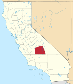
| State | California |
| County | Tulare |
| Elevation | 4,711 ft (1,436 m) |
| Time zone | Pacific (PST) (UTC-8) |
| • Summer (DST) | PDT (UTC-7) |
| Area code(s) | 559 |
| GNIS feature ID | 1660818[1] |
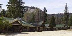
Johnsondale is an unincorporated community in Tulare County, California, United States. Johnsondale is 20 miles (32 km) northeast of California Hot Springs. A post office opened in Johnsondale in 1939. The community is named after Walter Johnson of the Mount Whitney Lumber Company.[2]
Climate
According to the Köppen Climate Classification system, Johnsondale has a semi-arid climate, abbreviated "BSk" on climate maps.[3]
References
- ↑ U.S. Geological Survey Geographic Names Information System: Johnsondale, California
- ↑ Durham, David L. (1998). California's Geographic Names: A Gazetteer of Historic and Modern Names of the State. Quill Driver Books. p. 1052. ISBN 1-884995-14-4.
- ↑ Climate Summary for Johnsondale, California
This article is issued from Wikipedia - version of the 10/28/2016. The text is available under the Creative Commons Attribution/Share Alike but additional terms may apply for the media files.