Kota Kinabalu
| Kota Kinabalu Jesselton | |||
|---|---|---|---|
| City and State Capital | |||
| Other transcription(s) | |||
| • Jawi | کوتا کينا بالو | ||
| • Simplified Chinese | 亚庇 | ||
| • Traditional Chinese | 亞庇 | ||
|
From top right clockwise: Tun Mustapha Tower, Swordfish Statue, Wawasan intersection, Wisma Tun Fuad Stephens, city centre street level and 1Borneo Mall. | |||
| |||
|
Nickname(s): KK, Bandaraya Peranginan Semulajadi (Nature Resort City) | |||
 Location of Kota Kinabalu in Sabah | |||
 Kota Kinabalu Location of Kota Kinabalu within Malaysia | |||
| Coordinates: 5°58′17″N 116°05′43″E / 5.97139°N 116.09528°ECoordinates: 5°58′17″N 116°05′43″E / 5.97139°N 116.09528°E | |||
| Country |
| ||
| State |
| ||
| Division | West Coast | ||
| Bruneian Empire | 15th–18th century | ||
| Settled by BNBC | 1882 | ||
| Declared capital of North Borneo | 1946 | ||
| Granted city status | 2 February 2000 | ||
| Government | |||
| • Mayor | Yeo Boon Hai | ||
| Area | |||
| • City and State Capital | 351 km2 (136 sq mi) | ||
| • Metro | 816 km2 (315 sq mi) | ||
| Elevation[1] | 5 m (16 ft) | ||
| Population (2010) | |||
| • City and State Capital | 452,058 | ||
| • Density | 1,463/km2 (3,790/sq mi) | ||
| • Metro | 628,725 | ||
| • Metro density | 770.5/km2 (1,996/sq mi) | ||
| • Demonym | Orang KK / K.K-ites / K.K-ians | ||
| Sourced from the Population and Housing Census of Malaysia 2010. Kota Kinabalu metropolitan area includes population of 176,667 in the Penampang, Papar and Tuaran districts. | |||
| Time zone | MST (UTC+8) | ||
| Postal code | 88xxx; 89xxx | ||
| Area code(s) | 088, 087 | ||
| Vehicle registration |
EJ, EJA, EJB (1967–1980)[2][3] SA, SAA, SAB, SAC (1980–present) | ||
| Website |
dbkk | ||


Kota Kinabalu (Malaysian pronunciation: [ˈkota kinaˈbalu], Jawi: کوتا کينا بالو, Chinese: 亚庇; pinyin: Yàbì), formerly known as Jesselton,[4][5] is the capital of the state of Sabah, Malaysia. It is also the capital of the West Coast Division of Sabah. The city is located on the northwest coast of Borneo facing the South China Sea. The Tunku Abdul Rahman National Park[6] lies to its west and Mount Kinabalu, which gave the city its name, is located to its east. Kota Kinabalu has a population of 452,058 according to the 2010 census;[7] when the adjacent Penampang and Putatan districts are included, the metro area has a combined population of 628,725.[7]
In the 15th century, the area of Kota Kinabalu was under the influence of Bruneian Empire. In the 19th century, the British North Borneo Company (BNBC) first set up a settlement near the Gaya Island. However, it was destroyed by fire in 1897 by a local leader named Mat Salleh. In July 1899, the place located opposite to the Gaya Island was identified as a suitable place for settlements. Development in the area was started soon after that; and the place was named "Api-api" before it was renamed after the vice-chairman of BNBC as "Jesselton". Jesselton became a major trading port in the area, and was connected to the North Borneo Railway. Jesselton was largely destroyed during World War II. The Japanese occupation of Jesselton provoked several local uprisings but they were eventually defeated by the Japanese. After the war, BNBC was unable to finance the high cost of reconstructions and the place was ceded to the British Crown Colony. The British Crown declared Jesselton as the new capital of North Borneo in 1946 and started to rebuild the town. After the formation of Malaysia, North Borneo was reamed as Sabah. In 1967, Jesselton was renamed as Kota Kinabalu. Kota Kinabalu was granted city status in 2000.
Kota Kinabalu is often known as KK both in Malaysia and internationally. It is a major tourist destination and a popular gateway for travellers visiting Sabah and Borneo.[5][8] Kinabalu Park is located about 90 kilometres from the city and there are many other tourist attractions in and around the city. Kota Kinabalu is also one of the major industrial and commercial centres of East Malaysia. These two factors combine to make Kota Kinabalu one of the fastest growing cities in Malaysia.[9]
Etymology

Kota Kinabalu is named after Mount Kinabalu, which is situated about 50 kilometres east-northeast of the city. Kinabalu is derived from the name Aki Nabalu meaning the "revered place of the dead." Aki means "ancestors" or "grandfather", and Nabalu is a name for the mountain in the Dusun language.[10] There is also a source claiming that the term originated from Ki Nabalu, Ki meaning "have" or "exist", and Nabalu meaning "spirit of the dead".[11]
Kota is a Malay word for a "fort", "town", or a "city". It is also used formally in a few other Malaysian towns and cities, for example, Kota Bharu, Kota Tinggi, and Kota Kemuning. It can also be used informally to refer to any towns or cities. Hence, a direct translation of the name Kota Kinabalu into English would be "City of Kinabalu" or "Kinabalu City".
Original names
Besides Jesselton, there are also other older names for Kota Kinabalu. The most popular is Api-Api, or simply Api, which is a Malay word meaning 'Fire'.[6] Wendy Law Suart wrote in her book on North Borneo, The Lingering Eye, "there is in the Sabah State Museum a Dutch map of Borneo and the Celebes dated 1657 in which the settlement where Jesselton was to stand is clearly labelled Api Api. It may have some connection with the seaside tree with breathing roots that bears the same name".[12] There are claims, however, that Kota Kinabalu was actually named after a nearby river called Sungai Api-Api. In Chinese, the city is still known as 'Api', which is the Hakka pronunciation for 亚庇 (Simplified Chinese; Traditional Chinese: 亞庇; Pinyin: yà bì).
Another suggested historical name is Deasoka, which roughly means "below the coconut tree" in the Bajau language.[13] The Bajau locals purportedly used this name to refer to a village in the southern part of the city which was filled with coconut trees. Yet another name was Singgah Mata which literally means "transit eye", but can be loosely translated as "pleasing to the eye". It is a name said to have been given by fishermen from Gaya Island referring to the strip of land that is today's downtown Kota Kinabalu.[14] Today, all these names have been immortalised as names of streets or buildings around the city. Some examples are Lintasan Deasoka, Api-Api Centre and Singgah Mata Street.
History
Since the 15th century, the area of Jesselton was under the influence of the Bruneian Empire.[15][16] In the late 1800s, the British North Borneo Company (BNBC) began to establish colonies throughout North Borneo.[17] In 1882, BNBC founded a small settlement in the area known as Gaya Bay, which was already inhabited by Bajau people.[18] The first settlement was on Gaya Island.[6] In 1897, this first settlement was burned and destroyed by the indigenous Bajau-Suluk chief Mat Salleh.[16]
After the destruction, BNBC decided to relocate the settlement to the more easily defended mainland at Gantian Bay (now Sepanggar Bay) in 1898.[19] However that location was found to be unsuitable and in July 1899, Mr. Henry Walker, a Land Commissioner, identified a 30 acres (12 ha) site opposite Gaya Island as a replacement for Gantian.[20] This fishing village named Api-Api (see Original names above) was chosen due to its proximity to the North Borneo Railway and its natural port that provided good anchorage, which was up to 24 feet deep.[6]

By the end of 1899, construction had started on shoplots,[21] a pier and government buildings.[20] This new administrative centre was renamed Jesselton after Sir Charles Jessel, who was the then Vice-Chairman of BNBC. Eventually, Jesselton became a major trading post of North Borneo, dealing in rubber, rattan, honey, and wax.[6][22] The North Borneo Railway was used to transport goods to the Jesselton harbour.[22] The Malay and Bajau uprisings during those times were not uncommon, and BNBC worked to quell the long-standing threat of piracy in the region. Jesselton suffered a large-scale destruction when it was razed by the British in their retreat from the Japanese and suffered more destruction when the Allies bombed it in 1945.[23] After the Japanese takeover of Borneo, it was again renamed Api. Several rebellions against the Japanese military administration took place in Api. One major rebellion occurred on 10 October 1943 by a group called Kinabalu Guerrillas, consisting of local inhabitants. Japanese forces quelled the rebellion after its leader, Albert Kwok, was arrested and executed in 1944.[24] At the later stages of the war, what remained of the town was destroyed again by Allied bombings day and night for over six months as part of the Borneo Campaign in 1945, leaving only three buildings standing.[6] The war in North Borneo ended with the official surrender of the Japanese 37th Army by Lieutenant General Baba Masao in Labuan on 10 September 1945.[25]
.JPG)
After the war on the edge of bankruptcy, the British North Borneo Company returned to administer Jesselton but was unable to finance the huge costs of reconstruction. They gave control of North Borneo to the British Crown on 18 July 1946. The new colonial government elected to rebuild Jesselton as the capital of North Borneo instead of Sandakan, which had also been destroyed by the war.[26] The Crown Colony administration designed a plan, later known as the "Colonial Office Reconstruction and Development Plan for North Borneo: 1948–1955”, to rebuild North Borneo. This plan provided £6,051,939 for the rebuilding of infrastructure in North Borneo.[27] When the Crown Colony of North Borneo together with Sarawak, Singapore and the Federation of Malaya formed the Federation of Malaysia in 1963, it became known as Sabah, and Jesselton remained its capital.[28] On 22 December 1967, the State Legislative Assembly under Chief Minister Tun Mustapha bin Datu Harun passed a bill renaming Jesselton as Kota Kinabalu. The city was upgraded to city status on 2 February 2000.[28]
Capital city

Being the capital city of Sabah, Kota Kinabalu plays an important role in the political and economic welfare of the population of the entire state. It is the seat of the state government where almost all of their ministries and agencies are based. Most of the Malaysian federal government agencies and departments are also located in Kota Kinabalu. The Sabah State Legislative Assembly is located at the nearby Likas Bay. There are four members of parliament (MPs) representing the four parliamentary constituencies in the city: Sepanggar (P.171), Kota Kinabalu (P.172), Putatan (P.173), and Penampang (P.174). The city also elects 9 representatives to the state legislature from the state assembly districts of Karambunai, Inanam, Likas, Api-Api, Luyang, Tanjung Aru, Petagas, Kepayan, Segama, Menggatal, Tuaran, Lido, and Moyog.[29]
Local authority and city definition

The city is administered by the Kota Kinabalu City Hall (Dewan Bandaraya Kota Kinabalu). The current mayor of Kota Kinabalu is Yeo Boon Hai, who took over from Datuk Abidin Madingkir on 2 February 2016.[30] Datuk Iliyas in turn became the second mayor of the city after taking over from Datuk Abdul Ghani Rashid in 2006. The city obtained city status on 2 February 2000,[28] and prior to this it was administered by Majlis Perbandaran Kota Kinabalu (Kota Kinabalu Municipal Council/Kota Kinabalu Town Hall).

The city is defined within the borders of what is the district, formerly the municipality, of Kota Kinabalu. With an area of 351 square kilometres, it is the smallest but the most populous district in Sabah.[31] It encompasses Tanjung Aru and Kepayan in the south, up to Telipok and Sepanggar in the north. The urban expanse of the city however extends into the district of Penampang[32] on the south of the city border, which includes the towns of Donggongon and Putatan. The combined area of Kota Kinabalu (district) and the contiguous built up areas in Penampang and Putatan is known as Greater Kota Kinabalu.[33] The district of Penampang has an area of 466 square kilometres, and is administered by Majlis Daerah Penampang (Penampang District Council).[34]
On one end of the scale, Kota Kinabalu may sometimes only refer to, especially by local inhabitants, the city centre or central business district near the sea facing Gaya Island. On the other end of the scale, it may also refer to the metropolitan area which includes urban Kota Kinabalu (Greater Kota Kinabalu), and the surrounding towns of Papar and Kinarut in the south, and Tuaran and Tamparuli in the north, being within its zone of influence.
Geography
.jpg)
Kota Kinabalu is located on the west coast of Sabah. The city lies on a narrow flatland between the Crocker Range to the east and the South China Sea to the west. There are six islands off the coast of the city. The largest is Gaya Island, the site of the first British settlement. Approximately 8,000 people live there.[35] The smaller islands, mainly uninhabited, are named Sapi Island, Manukan Island, Sulug Island, Mamutik Island and Sepanggar Island to the north.[36] Sepanggar island is located north of the National Park opposite Sepanggar Bay.
Flat land is at a premium in the city centre, and there is a strict limit to the height of buildings: the airport is 7 km (4 mi) away, and the city is directly in the flight path. Most of the Central Business District (CBD) today is built on land reclaimed from the sea.[6] The original local plant life has largely disappeared, but several hills within the city (too steep for building) are still clothed with tropical rainforest. One of these is Signal Hill, which confines the CBD to the shore. In the area of Likas Bay, the remnants of an extensive mangrove forest was nearly lost.[37] In 1996, a perceptive state government stepped in and declared 24 acres (9.7 ha) of the forest as a protected area. This forest is now known as the Kota Kinabalu City Bird Sanctuary. The sanctuary was given additional protection as a State Cultural Heritage Site in 1998.[37]

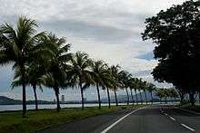
The five islands (of Gaya, Sapi, Manukan, Sulug, Mamutik) opposite the city, and their surrounding waters, are also preserved as the Tunku Abdul Rahman National Park.[6] The park was named in honour of the first Prime Minister of Malaysia, Tunku Abdul Rahman. The park is a popular recreational spot for tourists and local people.[38] The Kota Kinabalu city centre, consisting of mostly businesses and the government, includes Karamunsing, the port area (Tanjung Lipat), Signal Hill, Kampung Air, Sinsuran, Segama, Asia City, Gaya Street (Old Town), Bandaran Berjaya, Api-Api, Sutera Harbour and Sembulan. Outlying neighbourhoods and residential suburbs include Kepayan Ridge, Tanjung Aru, Petagas, Kepayan, Lido, Lintas, Nosoob, Bukit Padang, Luyang, Damai, Lok Kawi, Bukit Bendera, Kasigui, Bundusan, Likas and Kolombong. The city is growing steadily and the urban sprawl extends to the towns of Inanam, Menggatal, Sepanggar, Telipok and south of the district border to Penampang, Putatan, and Lok Kawi.[39] Kota Kinabalu is generally isolated from the rest of the country; it is located about 1,624 kilometres (1,009 mi) from Kuala Lumpur in Peninsular Malaysia[40] and 804 kilometres (500 mi) from Kuching in the neighbouring state of Sarawak.[41]
Climate
As part of Sabah area, Kota Kinabalu features a typical equatorial climate with constant temperature, considerable amount of rain and high humidity.[42] Two prevailing monsoons characterise the climate of this part of Sabah are the Northeast Monsoon and the Southwest Monsoon. The Northeast Monsoon occurs between November and March, while the Southwest Monsoon occurs between May and September. There are also two successive inter-monsoons from April to May and from September to October.[42]
During the 1995–2004 period, Kota Kinabalu's average temperature ranges from 26 °C (79 °F) to 28 °C (82 °F).[43] April and May are the hottest months, while January is the coolest one.[42] The average annual rainfall is around 2,400 millimetres[43] and varies markedly throughout the year. February and March are typically the driest months while rainfall peaks in the inter-monsoon period in October.[44] The wind speed ranges from 5.5 to 7.9 m/s during the Northeast Monsoon but is significantly lower to 0.3 to 3.3 m/s during the Southwest Monsoon.[45]
| Climate data for Kota Kinabalu (1971–2000, extremes 1946–1999) | |||||||||||||
|---|---|---|---|---|---|---|---|---|---|---|---|---|---|
| Month | Jan | Feb | Mar | Apr | May | Jun | Jul | Aug | Sep | Oct | Nov | Dec | Year |
| Record high °C (°F) | 35.0 (95) |
34.2 (93.6) |
35.7 (96.3) |
35.6 (96.1) |
35.3 (95.5) |
35.6 (96.1) |
34.1 (93.4) |
35.0 (95) |
34.0 (93.2) |
33.3 (91.9) |
33.5 (92.3) |
32.4 (90.3) |
35.7 (96.3) |
| Average high °C (°F) | 30.4 (86.7) |
30.7 (87.3) |
31.5 (88.7) |
32.2 (90) |
32.1 (89.8) |
31.8 (89.2) |
31.5 (88.7) |
31.6 (88.9) |
31.4 (88.5) |
31.2 (88.2) |
31.0 (87.8) |
30.9 (87.6) |
31.4 (88.5) |
| Average low °C (°F) | 22.9 (73.2) |
23.0 (73.4) |
23.4 (74.1) |
24.1 (75.4) |
24.3 (75.7) |
24.0 (75.2) |
23.7 (74.7) |
23.7 (74.7) |
23.7 (74.7) |
23.6 (74.5) |
23.5 (74.3) |
23.3 (73.9) |
23.6 (74.5) |
| Record low °C (°F) | 18.0 (64.4) |
17.0 (62.6) |
18.0 (64.4) |
18.0 (64.4) |
18.0 (64.4) |
18.0 (64.4) |
17.0 (62.6) |
16.0 (60.8) |
17.0 (62.6) |
19.0 (66.2) |
18.0 (64.4) |
18.0 (64.4) |
16.0 (60.8) |
| Average rainfall mm (inches) | 104.8 (4.126) |
73.4 (2.89) |
50.5 (1.988) |
114.2 (4.496) |
216.2 (8.512) |
279.4 (11) |
262.7 (10.343) |
270.3 (10.642) |
285.2 (11.228) |
345.8 (13.614) |
302.4 (11.906) |
242.3 (9.539) |
2,547.2 (100.283) |
| Average rainy days (≥ 1.0 mm) | 8 | 7 | 6 | 8 | 12 | 13 | 13 | 13 | 14 | 16 | 17 | 13 | 140 |
| Average relative humidity (%) | 83 | 82 | 81 | 80 | 81 | 80 | 79 | 78 | 81 | 82 | 83 | 83 | 81 |
| Mean monthly sunshine hours | 187.7 | 194.8 | 233.4 | 245.3 | 228.8 | 197.6 | 204.9 | 196.7 | 180.7 | 191.9 | 192.5 | 197.5 | 2,451.8 |
| Source #1: World Meteorological Organisation[46] | |||||||||||||
| Source #2: NOAA (sun, 1961–1990), [47] Deutscher Wetterdienst (extremes and humidity)[48] | |||||||||||||
Demography
There have not been any official or popular adjectives, or demonyms, to describe the people of Kota Kinabalu. A simple way to describe the people of the city is "orang KK", where orang means "person" or "people" in Malay. The terms "K.K-ites"[9] and "K.K-ians" have also been used to a limited extent. People from Sabah are called Sabahans.[49]
Ethnicity and religion
The following is based on Department of Statistics Malaysia 2010 census.[50]
| Ethnic groups in Kota Kinabalu, 2010 | ||
|---|---|---|
| Ethnicity | Population | Percentage |
| Chinese | 93,429 | 20.7% |
| Bajau | 72,931 | 16.13% |
| Kadazan-Dusun | 69,993 | 15.5% |
| Other Bumiputras | 59,607 | 13.2% |
| Bruneian Malays | 35,835 | 7.9% |
| Murut | 2,518 | 0.6% |
| Indian | 2,207 | 0.5% |
| Others | 5,482 | 1.21% |
| Non-Malaysian | 110,556 | 24.5% |

The Malaysian Census 2010 Report estimated the population of Kota Kinabalu at 452,058.[50] The city's population today is a mixture of many different races and ethnicities. Non-Malaysian citizens form the majority of the city population with 110,556 people followed by Chinese (93,429), Bajau/Suluk (72,931), Kadazan-Dusun (69,993), other Bumiputras (59,107), Bruneian Malays[51] (35,835), Murut (2,518), Indian (2,207) and others (5,482).[50] The Chinese are mostly Hakkas and reside mainly in the Luyang area. There is also a sizeable Cantonese-speaking population and smaller communities of Hokkien and Foochow-speaking Chinese scattered throughout all areas of the city. Most of the Foochow speakers in particular emigrated to Sabah from the neighbouring Malaysian state of Sarawak. Penampang district is populated mainly by Kadazans, while Bajaus and Dusuns mainly reside in Likas, Sembulan, Inanam, Menggatal, Sepanggar and Telipok. The Brunei Malays and Bajau/Suluks are Muslims. The Kadazan-Dusuns and Muruts mainly practice Christianity, Islam or Animism, whilst the Chinese are mainly Buddhists, Taoist or Christians. There are numerous Roman Catholic, Basel (Lutheran), Anglican, Evangelical, and Methodist churches throughout the city. A small number of Hindus, Sikhs, Animists, and secularists can also be found.

There is also a sizeable Filipino population in the city. The first wave of migrants arrived in the late 15th century during the Spanish colonisation, while a later wave arrived in the early 1970s, driven away from the Philippines by political and economic uncertainties there. Most of the earlier migrants have been naturalised as Malaysian citizens. However, there are still some Filipinos living in the city without proper documentation as illegal immigrants.[52] Most of the Filipino migrants are Tausūgs (Suluk) coming from the southern parts of Philippines.[53] The city also is home to immigrants from Indonesia.[53]
There is a small population of Indians, Pakistanis and Eurasians scattered around the city. More recently, the number of expatriates living in the city, whether temporarily or permanently, have also increased. Most of them come from China, South Korea, Japan, Australia, Taiwan and Europe. Interracial marriages are not uncommon and Kadazan-Chinese intermarriages are particularly common.[54] The mixed race offspring of Kadazan and Chinese are referred to as Sino-Kadazans or simply "Sinos".[54]
Languages
The people of Kota Kinabalu mainly speak Malay, with a distinct Sabahan creole.[49] However, as almost 50% of Kota Kinabalu residents are of Chinese descent,[55] Chinese is also widely spoken. Among the Chinese, the most commonly spoken varieties are Huiyang Hakka (Simplified Chinese: 惠阳客家话; Traditional Chinese: 惠陽客家話) and Mandarin. Additionally, most Chinese can speak Cantonese, although with widely varying levels of fluency. Almost all residents are also able to speak English, especially the younger generation. However, some find it difficult to speak fluently due to a limited vocabulary and the general lack of usage of the English language as a conversational lingua franca among Sabahans as a whole.
The number of Kadazan-Dusun speakers is thought to have dropped significantly throughout Sabah, especially in larger towns or cities like Kota Kinabalu. However, some effort has been taken by some to revive the usage of the language. Kadazan has been considered an endangered language, along with the culture of ethnic Kadazans.[56]
Economy
Besides being the capital city, Kota Kinabalu is also the main industrial and commercial centre for Sabah. The economy is dominated by the primary sector of industry. Historically, the secondary sector dominated the economy, but due to rapid urbanisation and economic development, this sector of the economy is slowly diminishing. More recently, a move towards a more tertiary-based industry has become more apparent, especially with regards to the boom in the tourism industry.[8] Many state-level, national-level and international commercial banks, as well as some insurance companies have their headquarters or branches here. The overseas Chinese population also contributes to the development of KK since their immigration in the late 19th century.[57] Their original role involved 'coolie' (slavery work) and today many Chinese work as shopowners.[57]

A number of industrial and manufacturing companies also have plants here, especially in the industrial districts of Likas, Kolombong, and Inanam. The ongoing construction of the 8,320-acre (33.7 km2) Kota Kinabalu Industrial Park (KKIP) in Sepanggar is intended to boost the city's industrial and commercial activity, making it a major growth centre in East Malaysia, as well for the BIMP-EAGA (Brunei-Indonesia-Malaysia-Philippines East ASEAN Growth Area) region.[58] Kota Kinabalu also hosts numerous national, regional and international conferences or trade fairs every year, including the biennial Sabah International Expo, the Asia Pacific eTourism Conference by the United Nations Conference on Trade and Development (UNCTAD), the ASEAN Australian Engineering Congress, and many others. These events are normally held at the Sutera Harbour resort.
Transportation
Land

The internal roads linking different parts of the city are generally state roads constructed and maintained by the state's Public Works Department.[59] Most major internal roads are dual-carriageways. One of the major roads here is Lintas-Tuaran Bypass Road, which together serves almost as a ring road, circling the city and connecting the districts and suburbs surrounding the city, namely Putatan, Penampang, Luyang, Likas, Inanam, Menggatal, Sepanggar and Tuaran. There are currently no freeways in the city or in any other part of Sabah. The city is linked by highways to other towns in Sabah. These are mainly federal roads maintained by the national Public Works Department. Highway routes from Kota Kinabalu include:[60]
- Kota Kinabalu – Tuaran – Tamparuli – Kota Belud – Kota Marudu – Pitas – Kudat
- Kota Kinabalu – Penampang – (Putatan – Lok Kawi) – Papar – Beaufort – Sindumin (part of the Pan Borneo Highway)
- Kota Kinabalu – Penampang – Tambunan – Keningau – Tenom – Nabawan (part of the Pan Borneo Highway)
- Kota Kinabalu – Tuaran – Tamparuli – Kundasang – Ranau – Telupid – Sandakan – Tawau (part of the Pan Borneo Highway)
Public transportation

Regular bus services operate in the city. Aside from buses, minibuses or vans are used as an alternative mode of public transport.[61] There are two main bus terminals in the city centre. The terminal along Tun Razak Road provide bus services to different parts of the city and its outskirts, while the terminal near Bandaran Berjaya provides intercity services to destinations south of the city (Papar, Tenom, Beaufort etc.). A third bus terminal, the North Kota Kinabalu Bus Terminal in Inanam district, services intercity buses heading towards destinations north and north-east of the city (Tuaran, Kudat, Ranau, Sandakan, Tawau, Semporna etc.). Taxis are available throughout the city.[61]
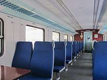
A railway system formerly known as the North Borneo Railway was established in 1896 by the British North Borneo Company.[22][62] It was built for the main purpose of transporting commodities from the Interior Division to the port in Kota Kinabalu during the British occupation.[22] The railway line connects Kota Kinabalu to Tenom and several other towns in between, and it is the only railway system operating in East Malaysia.[22][62] Today, the railway is known as the Sabah State Railway, and it provides daily services for commuters, travellers, as well as for cargo transportation.[22] A separate company operates the leisure tour also called the North Borneo Railway, which caters mainly for tourists. The train station and terminal is located in Tanjung Aru.[22]
Air
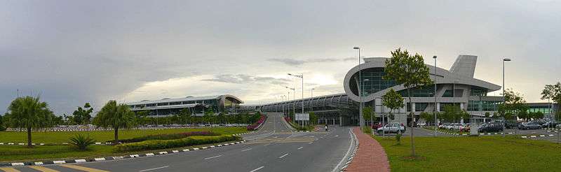
Kota Kinabalu International Airport (KKIA) (ICAO Code : WBKK) is a main hub for Malaysia Airlines and a secondary hub for AirAsia and MASWings. It has one terminal[63] and is the second busiest airport in Malaysia after Kuala Lumpur International Airport and is one of the main gateways into Sabah and East Malaysia.[64] In addition to domestic flights within Sabah and Malaysia, KKIA is also serviced by international flights to several cities in southeast and northeast Asia, as well as Perth in Australia. The city will also become a secondary hub for a new airline called flymojo.[65]
Sea

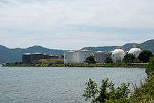
Kota Kinabalu has two ports: Kota Kinabalu Port and Sepanggar Bay Container Port (SBCP). Kota Kinabalu Port mainly handles loose/bulk cargo, while SBCP operates as a naval base for the Royal Malaysian Navy and an oil depot in addition to handling containerised cargo.[66] In 2004, Kota Kinabalu Port handled about 3.6 million tonnes of freight cargo, the third highest in the state after Sandakan Port and Tawau Port.[31] However, it handles the highest number of containers in the state, with 153,793 twenty-foot equivalent units (TEU) of containers handled in 2006. Sepanggar Bay Port will have an annual capacity of 200,000 TEU when its container terminal is completed.[67] All ports in Sabah are managed and operated by Sabah Ports Sdn Bhd.[68]
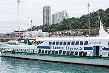
The Kota Kinabalu Ferry Service operates from a passenger ferry terminal located at Jesselton Point,[69] providing ferry and motorboat services to nearby islands. There are also regular scheduled ferry services to Labuan.[69]
Other utilities
Courts of law and legal enforcement

The current court complex is located along Tugu Road.[70] It contains the High Court, Sessions Court, and the Magistrate Court.[71] Another court for the Sharia law were also located in the area of Sembulan.[72]
The Sabah Police Contingent Headquarters is located in Kepayan. There are two district headquarters in the city, the Kota Kinabalu District police headquarters located in Karamunsing, and the Penampang District headquarters. Both also operate as police stations. Other police stations are found in KKIA, Tanjung Aru, Putatan, and Menggatal. Police substations (Pondok Polis) are found in Luyang, Likas, Telipok and Babagon.[73] The city's traffic police headquarters is located along Lorong Dewan near Gaya Street, and the marine police headquarters is located near the city ferry terminal along Tun Razak Road.
Kota Kinabalu Central Prison is located in Kepayan.[74] Temporary lock-ups or prison cells are found in most police stations around the city.
Healthcare

There are three public hospitals, six publics health clinic, two child and mother health clinics, six village clinics, one mobile clinic and six 1Malaysia clinics in Kota Kinabalu.[75][76] Queen Elizabeth General Hospital, which is located along Penampang Road and named after Queen Elizabeth II, is the largest public hospital in the state with 589 beds.[77] Built in 1957, it is the most important healthcare centre in the city and one of three general hospitals in Sabah. Queen Elizabeth Hospital II was established then after the acquisition of the former building of Sabah Medical Centre (SMC) in 2009. The second main government hospital are mainly used for heart centre. Hospital Wanita dan Kanak-kanak (Sabah Women and Children Hospital) serves as a referral hospital for children and women. Hospital Mesra Bukit Padang (Bukit Padang Mental Hospital), which opened in 1971, provides psychiatric services for the entire state.
KPJ Specialist Hospital is the largest private hospital with 245 beds.[78] In addition, five other large private health facilities are Gleneagles Kota Kinabalu with 200 beds,[79] Jesselton Medical Centre (JMC) with 73 beds,[80] Damai Specialist Centre (DMC) with 56 beds[81] and Rafflesia Medical Centre (RMC) with 33 beds.[82]
Education
There are many government or state schools in and around the city. Among the well-established and prestigious boarding schools in Sabah is Sekolah Menengah Sains Sabah, formally known as Sekolah Berasrama Penuh Sabah (SBPS), which is located at Bukit Padang.[83] Other secondary schools are KK High School, SM La Salle, Sekolah Menengah Shan Tao, Sekolah Menengah Taman Tun Fuad, Sekolah Menengah Likas, Sekolah Menengah Kebangsaan Perempuan Likas, Sekolah Menengah Kebangsaan St. Francis Convent, Sekolah Menengah All Saints, Sekolah Menengah Stella Maris, Sekolah Menengah Saint Michael, Maktab Sabah , Sekolah Menengah Lok Yuk, Sekolah Menengah Kebangsaan Agama Kota Kinabalu and Sekolah Menengah Kebangsaan Agama Tun Ahmadshah.[83] There are also a number of independent private schools in the city. Among them are Sabah Tshung Tsin Secondary School, Kian Kok Middle School, Maktab Nasional and Seri Insan Secondary School.[84] Classes usually begin at 7 am and end at 1 pm except for boarding schools, in which classes begins as early as 6.30 am and end at 2 pm. Children aged 7 must attend primary education, which consists of six years of learning, while those aged 13 can pursue their studies in lower secondary education for three years. After completing their Lower Secondary Examination, students enter Upper Secondary education, where they will be streamed into either the Science stream or the Arts stream based on their examination results. Students who choose to study at boarding schools will be placed into the Science stream. Currently, there are four boarding schools in Sabah.

There are two international schools teaching the British Curriculum. Sayfol International School Sabah teaches from kindergarten to the GCE 'A' Levels, which is taken at age 18 (pre-university).[85] Sayfol International School is the sister school of the established and highly successful Sayfol International School in Kuala Lumpur. Kinabalu International School (KIS) is part of the Federation of British International Schools in South and East Asia (FOBISSEA). Both English medium schools are located in Bukit Padang. Another international school is the Kinabalu Japanese School, one of four Japanese schools in Malaysia and the Kota Kinabalu Indonesian School.[86][87] Both schools caters to children of Japanese and Indonesian expatriates working and living around the city.
Universiti Malaysia Sabah (UMS), founded in 1994, is the largest university in Sabah. Its main campus is located on a 999-acre (4.04 km2) piece of land, on a hill facing the South China Sea at Sepanggar Bay, about 10 kilometres north of the city centre. It also has branch campuses in Labuan and Sandakan. It is considered as one of the most beautiful universities in Malaysia.[88] The oldest university in Sabah is Universiti Teknologi MARA Sabah which was co-founded by UiTM and Yayasan Sabah in 1973. The university has been certified by the Kota Kinabalu City Hall as a litter-free university.[89] There are also a number of private colleges and one polytechnic operating in the city, which are Universiti Tun Abdul Razak, AlmaCrest International College, INTI College, Kinabalu Commercial College, Informatics College, Kota Kinabalu Polytechnic and Institut Sinaran.[90] The established Public College Tunku Abdul Rahman is located in the Donggongon area. Many affluent residents send their children overseas to pursue either secondary or tertiary education.

Libraries:
The Sabah State Library Headquarters is located off Penampang Road and is the largest library in the state. Other public libraries include the Kota Kinabalu City (Regional) Library, Penampang Branch Library and Menggatal Village Library. These libraries are operated by the Sabah State Library department.[91] Other libraries or private libraries can be found in schools, colleges, or universities.[75]
Culture and leisure
Attractions and recreation spots
Cultural

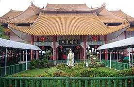
There are a number of cultural venues in Kota Kinabalu. The Sabah State Museum, situated near the Queen Elizabeth Hospital, is the main museum of Sabah.[6] In the vicinity of the museum are the Science and Technology Centre, Sabah Art Gallery, and the Ethno Botanic Gardens. Wisma Budaya Art Gallery in the city centre hosts some national as well as regional art exhibitions. The Hongkod Koisaan building in Penampang is home to the Kadazan-Dusun Cultural Association (KDCA).[92] It hosts the annual Kaamatan or Harvest Festival and the Unduk Ngadau beauty contest, which is held concurrently, in May. Monsopiad Cultural Village (Kampung Monsopiad) features cultural shows related to the Kadazan-Dusun culture. It is named after the legendary Kadazan-Dusun headhunting warrior, Monsopiad.[93]
Historical

The Padang Merdeka or Town Field is the site where the declaration of Sabah's independence and formation of Malaysia took place.[94] The declaration was announced by Sabah's first Chief Minister, Tun Fuad Stephens, on 16 September 1963, also known as Malaysia Day.[94] Today the site hosts the annual City Day celebration on 2 February, Merdeka Day celebration on 31 August, and a number of other celebrations and functions.
The Atkinson Clock Tower near Bandaran Berjaya was built by Mary Edith Atkinson in 1905 in memory of her son, Francis George Atkinson.[95] It was formerly used as a navigation aid for ships.[95] It is only one of three pre-World War II buildings to survive the war.[6] The Petagas War Memorial, located near KKIA, is a reminder of those who died when they went against the Japanese forces during World War II. It is situated at the place where the Kinabalu Guerillas were killed by the Japanese army in 1944. The Double Six Monument, located in Sembulan, is also a memorial to remember Sabah's first Chief Minister and six other state ministers who died on a plane crash known as the Double Six Tragedy on 6 June 1976.[96]
Leisure and conservation areas

There are many leisure spots and conserved areas in and around Kota Kinabalu. Anjung Samudra (KK Waterfront) is a waterfront entertainment spot in the city centre which features restaurants, cafes, pubs, and a nightclub. The Royal Sabah Turf Club in Tanjung Aru hosts weekly horse racing events but has since closed and moved to Tambalang Race Course in Tuaran due to the expansion of Kota Kinabalu International Airport. The North Borneo Railway, which begins its journey from Tanjung Aru station, offers a scenic tour of the countryside in the West Coast Division and the Interior Division.[22] The railway journey ends in the town of Tenom.[22] Sutera Harbour Golf & Country Club near the city centre was built on reclaimed land.[6] It features a golf and country club, a marina, and two hotels.

Tanjung Aru, located about 6 kilometres from the city centre, is one of the beaches along the West Coast. Its name was derived from the casuarina trees (locally called Aru trees) that grow on the shoreline.[97] The beach is over 2 kilometres in length and is complemented with a number food and drink stalls, restaurants, and night entertainment clubs. In the vicinity of Tanjung Aru lies the Kinabalu Golf Club, Prince Philip Botanical Park, KK Yacht Club, and Shangri-La's Tanjung Aru Beach Resort. This beach is famous for its sunset.[98][99]
Located within the Likas Bay area is the Kota Kinabalu City Bird Sanctuary. With an area of 24 acres (9.7 ha), it is one of the few remaining patches of mangrove forest that once existed extensively along the coastal region of Kota Kinabalu.[100] It was conserved in September 1996 by the State Government to assist and foster a better understanding and awareness of the value of wetlands. The Sabah Zoological and Botanical Park (Lok Kawi Wildlife Park) in Lok Kawi, about 20 kilometres south of the city, is the first zoo in Sabah. Set on a 280-acre (1.1 km2) piece of land, it is arguably the largest zoo in Malaysia.[101] The Green Connection aquarium just outside the centre of KK showcases the fish, coral and reptile biodiversity of Sabah, with exhibits on many of the aquatic ecosystems of Sabah. At the Green Connection aquarium, there are 5 of the top 10 wildlife icons of Borneo like sharks, rays, coral, fish and snakes.[102]

Tun Fuad Stephens Park, located in Bukit Padang, is a popular jogging and hiking spot among locals. It is surrounded by forests and also features a man-made lake. It has a few food stalls and restaurants. Tunku Abdul Rahman Park is a State Park consisting of the islands of Sapi, Mamutik, Manukan, Sulug and Gaya.[6] It is a popular spot for snorkelling. The park is about a 15 to 30 minutes boat ride away from the city ferry terminal. Babagon River in Penampang and Kiansom Falls near Inanam are also popular places for picnics and leisure bathing.[103]
Outside the city, Crocker Range Park, occupying a stretch of c. 20 x 80 km of the Crocker Range mountain chain to the city's southeast (roughly between Tenom and Tambunan, is a popular spot for jungle trekking and camping. Kota Kinabalu is also the gateway to one of the most popular conservation areas in Malaysia, Kinabalu Park.[104] The park is a two-hour drive away from the city and Mount Kinabalu, which is the 10th highest peak in South-East Asia and the highest in Malaysia, is located there. The Rafflesia Forest Reserve near Tambunan, which is 30 kilometres away from Kota Kinabalu, is also within the Crocker Range National Park boundary. One of the smaller species of Rafflesia, R. pricei, can be found there. The Gunung Emas Highland Resort, which is nearby, is another spot famous for its scenery and cool climate. The Tuaran Crocodile Farm, about 30 kilometres north of the city, has around 1400 crocodiles in its enclosure, making it the largest of its kind in Sabah.[105]

Other sights
The Tun Mustapha Tower (formerly Sabah Foundation Building) is about a 10-minute drive from the city centre. This 30-storey glass building is supported by high-tensile steel rods, one of only three buildings in the world that is built using this method.[106]
Other buildings and sites in the city are the stilt villages found in the areas of Sembulan, Tanjung Aru, Kampung Likas, and Kampung Pondo in Gaya Island.[107] These houses are built on shallow coastal waters and are homes for the Bajau and Suluk inhabitants.[108]
The Sabah State Mosque in Sembulan is the main mosque in the city. The City Mosque on Likas Bay is another significant landmark in the city.
The Signal Hill Observatory near the CBD offers a scenic view of the city centre, the islands, and the sea.[6]
Shopping

Kota Kinabalu also features a number of shopping malls. These include Imago KK Times Square, Oceanus Waterfront Mall, Karamunsing Complex, Centre Point, Wisma Merdeka, Warisan Square, Plaza Wawasan, Asia City Complex,[6] City Mall, KK Plaza, Mega Long Mall, Suria Sabah and 1Borneo, which is the largest hypermall in Kota Kinabalu.[109] Karamunsing, where Karamunsing Complex is situated, is an area that has more computer shops per capita than anywhere else in Sabah.[110] The weekly Gaya Street Sunday Market features a gathering of local hawkers selling a wide range of items from traditional ethnic cultural souvenirs to pets and flowers.[111] The Kota Kinabalu Handicraft Market (formerly known as the Filipino Market) features vendors selling traditional handicrafts, souvenirs and foodstuffs.[112]
Entertainment

There are seven cinemas in Kota Kinabalu: 2 Golden Screen Cinemas (commonly known as GSC), MBO cinemas located at Imago Mall Kota Kinabalu Times Square, City Cineplex at City Mall, Growball Cineplex at Centre Point Mall and Megalong Cineplex at Megalong Mall. One of the GSC cinemas is located at Suria Sabah Shopping Mall,[113] while the other is located at 1Borneo.[114] Both GSC cinemas hold eight cinema halls each.[115] 1Borneo HyperMall and Sutera Harbour Marina have bowling alleys and pool tables.[116] A new cinema known as the MBO Cinemas with a capacity of 1,038 is located in the newly Imago Mall, KK Times Square.[117]
Kota Kinabalu is well known as live seafood market. There are many live seafood restaurants such as Hua Hing Seafood Restaurant (located at Sedco Complex), Welcome Seafood Restaurant(Asia City) and Hung Xing Seafood Restaurant around the city.
Sports

The Likas Sports Complex in Kota Kinabalu provides various sporting and recreational facilities for public use.[75] It has, among others, a 20,000-seater football (soccer) stadium,[118] badminton, tennis, and squash courts, a gymnasium, an Olympic size swimming pool, a driving range, hockey fields and a new Youth Challenge park consisting of an international standard skate park and indoor climbing centre. It is the largest sports complex in the state and has hosted numerous national as well as international sporting events.[75] Likas Stadium is the home stadium of Sabah FA, also known as SabaHawks. There is another sports complex in Penampang which also has a full-sized football stadium.
There are four golf courses in Kota Kinabalu, namely the Sabah Golf and Country Club in Bukit Padang, Kinabalu Golf Club in Tanjung Aru, Sutera Harbour Golf and Country Club, and Karambunai Golf and Country Club.[119]
Kota Kinabalu has hosted a number of national sporting events such as the 2002 Sukma Games, international tournaments such as the 1994 Karate World Championships[120] and the 2008 BWF Super Series Masters Finals badminton tournament.[121] It is also the starting point of the annual international Borneo Safari 4x4 Challenge.[122] Kota Kinabalu has been one of the circuits for the F2 Powerboat UIM World Cup Series in December every year since 2007.[123]
Music
Kota Kinabalu is home to one of Asia's favourite jazz festivals, the KK Jazz Festival. It has become an annual event.[124] International performers such as Son2nos (Venezuela), award-winning Korean jazz diva Nah Youn Sun, Hong Kong's Junk Unit, Malaysia's Double Take, Atilia and Mood Indigo from UK have all previously performed at the festival.[125]
BandWidth Street Press Magazine is Kota Kinabalu's only free monthly magazine that promotes local Sabah music. The magazine was launched in March 2009, and was supported by the local government and was referred by Sabah's Minister of Culture, Environment & Tourism, YB Datuk Masidi Manjun, as a publication that will introduce and promote new local musicians while serving up the latest information on the local entertainment scene.[126]
Radio stations
Several local radio stations have their office in the city, this include Hitz FM Sabah (100.8), Kupi-Kupi FM (96.3), Era FM Sabah (102.4) and MY FM Sabah (104.0).
International relations
Several countries have set up their consulates in Kota Kinabalu, including Australia,[127] Brunei,[128] China,[129] Denmark,[130] France,[131] Finland,[132] Indonesia,[133] Japan,[134] Romania,[135] Slovakia,[136] Sweden[136] and the United Kingdom.[137][138]
Sister cities
Kota Kinabalu currently has six sister cities:
|
|
|
See also
References
Footnotes
- ↑ "Malaysia Elevation Map (Elevation of Kota Kinabalu)". Flood Map : Water Level Elevation Map. Archived from the original on 22 August 2015. Retrieved 22 August 2015.
- ↑ Brumby, Victor (1 May 2014). "May 1 MALAYSIA UPDATE and NOTES ON SUFFIXES". European Registration Plate Association (Europlate) blog. Archived from the original on 10 December 2015. Retrieved 10 December 2015.
About 1967, they added E as a prefix for new registrations in Sabah (for East Malaysia) (about 1967). and at unknown later date, added an S suffix to existing plates.
- ↑ "Malaysia license plates". wordllicenseplates.com. Archived from the original on 18 April 2015. Retrieved 10 December 2015.
- ↑ "Kota Kinabalu". ABC Sabah. Retrieved 12 August 2009.
- 1 2 "Dari Jesselton ke Kota Kinabalu" (in Malay). Utusan Malaysia. 25 February 2010. Archived from the original on 19 June 2013. Retrieved 19 May 2013.
- 1 2 3 4 5 6 7 8 9 10 11 12 13 14 Charles De Ledesma; Mark Lewis; Pauline Savage (2003). Malaysia, Singapore & Brunei. Rough Guides. pp. 508–. ISBN 978-1-84353-094-7. Retrieved 22 May 2013.
- 1 2 "Population Distribution by Local Authority Areas and Mukims, 2010 (page 1 & 8)" (PDF). Department of Statistics, Malaysia. Archived from the original (PDF) on 5 February 2015. Retrieved 10 April 2012.
- 1 2 "Tourism hub set to lift Sabah real estate". The Star. 11 June 2007. Archived from the original on 19 June 2013. Retrieved 15 January 2008.
- 1 2 Muguntan Vanar (20 September 2010). "Rapid development in Kota Kinabalu has its drawbacks". The Star. Archived from the original on 19 June 2013. Retrieved 3 January 2011.
- ↑ Tamara Thiessen (2008). Borneo. Bradt Travel Guides. pp. 155–. ISBN 978-1-84162-252-1.
- ↑ Sorudim, Lesaya (2 May 2005). "KINABALU: Kina Balu , Aki Nabalu, or Ki Nabalu?". KDCA Publications. Archived from the original on 28 September 2007. Retrieved 15 January 2008.
- ↑ Wendy Law Suart (1993) The Lingering Eye page 55, footnote
- ↑ "NAMA ASAL" (in Malay). DBKK Official Website. Archived from the original on 19 June 2013. Retrieved 19 May 2013.
- ↑ Sawatan, Jackson. "Adakah Gaya Sekadar 'Singgah mata' Untuk Pembangkang?". BERNAMA. Archived from the original on 29 September 2007. Retrieved 8 March 2007.
- ↑ Frans Welman. Borneo Trilogy Volume 1: Sabah. Booksmango. pp. 152–. ISBN 978-616-245-078-5.
- 1 2 Rozan Yunos (20 January 2011). "The History of Kota Kinabalu". The Brunei Times. Archived from the original on 10 May 2014. Retrieved 10 May 2014.
- ↑ "History of Sabah". Sabah Tourism Association (STA). Archived from the original on 27 March 2013. Retrieved 21 May 2013.
- ↑ Tamara Thiessen (2012). Borneo: Sabah – Brunei – Sarawak. Bradt Travel Guides. pp. 163–. ISBN 978-1-84162-390-0. Retrieved 17 June 2013.
- ↑ "NEW PORT IN NORTH BORNEO". The Singapore Free Press and Mercantile Advertiser (1884–1942), 17 April 1900, Page 3. National Library Singapore. Retrieved 21 May 2013.
- 1 2 "About KK (History)". DBKK Sabah. Archived from the original on 11 September 2008. Retrieved 21 May 2013.
- ↑ Cecilia Leong (1982). Sabah, the first 100 years. Percetakan Nan Yang Muda. p. 24.
- 1 2 3 4 5 6 7 8 9 "The North Borneo Railway Project". The International Steam Pages. Archived from the original on 28 March 2013. Retrieved 21 May 2013.
- ↑ Wong Seng Chow (10 March 2009). Rice Wine & Dancing Girls: The Real Life Drama of a Roving Cinema Manager in 50s Malaysia and Singapore. Monsoon Books. ISBN 978-981-08-1083-2. Retrieved 17 June 2013.
- ↑ Fujio, Hara (2013). "Chapter Eight – The 1943 Kinabalu Uprising in Sabah". In Paul H. Kratoska. Southeast Asian Minorities in the Wartime Japanese Empire. Taylor & Francis. pp. 111, 113. ISBN 978-1-136-12506-5.
- ↑ "Surrender Point Memorial, Labuan Island". Department of Veterans' Affairs. Archived from the original on 2 May 2014. Retrieved 21 May 2013.
- ↑ Muzium Sabah (1992), Sabah's heritage : a brief introduction to Sabah's history and heritage, Sabah Museum, retrieved 24 October 2013
- ↑ Ismail Ali. "The Role and Contribution of the British Administration and the Capitalist in the North Borneo Fishing Industry, 1945–63" (PDF). Sosiohumanika-jpssk.com. Archived from the original (PDF) on 24 February 2013. Retrieved 30 April 2013.
- 1 2 3 "Sabah – Lest We Forget". Tourism Malaysia. Archived from the original on 6 July 2013. Retrieved 17 June 2013.
- ↑ "List of Parliamentary Elections Parts and State Legislative Assemblies on Every States". Ministry of Information Malaysia. Archived from the original on 18 May 2014. Retrieved 19 May 2014.
- ↑ Muguntan Vanar (31 January 2016). "Yeo Boon Hai to be Kota Kinabalu mayor". The Star. Retrieved 31 January 2016.
- 1 2 "Monthly Statistical Bulletin: Sabah". Department of Statistics Malaysia, Sabah. January 2007.
- ↑ "Satellite image of Kota Kinabalu". Google Maps. Retrieved 17 March 2007.
- ↑ "Greater Kota Kinabalu Healthcare Overview" (PDF). Sabah Economic Development and Investment Authority (SEDIA). Retrieved 19 April 2012.
- ↑ "Main Page". Penampang District Council. Archived from the original on 7 August 2013. Retrieved 15 January 2008.
- ↑ "Cops storm Pulau Gaya, clash leaves one dead, four injured". The Star. 5 August 2006. Archived from the original on 19 June 2013.
- ↑ "Google Maps". Google Maps.
- 1 2 "WWF Malaysia, A City Oasis". 28 December 2006. Archived from the original on 24 February 2013. Retrieved 14 December 2008.
- ↑ "Tunku Abdul Rahman Park". Sabah Parks. Archived from the original on 13 March 2014. Retrieved 24 October 2013.
- ↑ "KK Map Guide". Sabah Travel Guide. Archived from the original on 31 March 2014. Retrieved 24 October 2013.
- ↑ "Distance from Kuala Lumpur, Malaysia to Kota Kinabalu, Malaysia". Archived from the original on 21 May 2009. Retrieved 5 June 2009.
- ↑ "Distance from Kuching, Malaysia to Kota Kinabalu, Malaysia". Retrieved 5 June 2009.
- 1 2 3 "Sabah Coastal Zone Profile 1998 – 3 CLIMATE (Part I)". Town and Regional Planning Department, Sabah. Archived from the original on 16 February 2012. Retrieved 2 June 2013.
- 1 2 Russel, Andy Immit Mojiol (2006). Ecological Landuse Planning and Sustainable Management of Urban and Sub-urban Green Areas in Kota Kinabalu, Malaysia. Cuvillier Verlag. p. 23. ISBN 978-3-86727-081-6.
- ↑ Russel 2006, p. 24
- ↑ Russel 2006, p. 25
- ↑ "World Weather Information Service – Kota Kinabalu". World Meteorological Organisation. Archived from the original on 23 October 2013. Retrieved 7 May 2014.
- ↑ "Kota Kinabalu Climate Normals 1961–1990". National Oceanic and Atmospheric Administration. Retrieved 7 May 2014.
- ↑ "Klimatafel von Kota Kinabalu (Jesselton) / Insel Borneo (Kalimantan) / Malaysia" (PDF). Baseline climate means (1961–1990) from stations all over the world (in German). Deutscher Wetterdienst. Retrieved 17 October 2016.
- 1 2 "PEOPLE OF SABAH". Discovery Tours Sabah. Archived from the original on 28 March 2014. Retrieved 21 May 2013.
- 1 2 3 "Total population by ethnic group, Local Authority area and state, Malaysia" (PDF). Statistics Department, Malaysia. 2010. Archived from the original (PDF) on 14 November 2013. Retrieved 12 March 2012.
- ↑ "Not Malays full stop". The Nut Graph. 22 November 2010. Archived from the original on 19 June 2013. Retrieved 21 May 2013.
Actually in Sabah, there were no Malays. You were either Bajau, or Murut, or Orang Sungai. The closest to Malays were the Brunei Malays because they were originally from Brunei before settling in Sabah
- ↑ Sadiq, Kamal. "When States Prefer Non-Citizens Over Citizens: Conflict Over Illegal Immigration into Malaysia". International Studies Quarterly (2005) 49. University of California–Irvine. pp. 101–122. Retrieved 24 October 2013.
- 1 2 Irvine Kamal Sadiq Assistant Professor of Political Science University of California (31 October 2008). Paper Citizens : How Illegal Immigrants Acquire Citizenship in Developing Countries: How Illegal Immigrants Acquire Citizenship in Developing Countries. Oxford University Press. pp. 48–. ISBN 978-0-19-970780-5. Retrieved 4 July 2013.
- 1 2 Chee-kiong Tong (2010). Identity and Ethnic Relations in Southeast Asia: Racializing Chineseness. Springer. pp. 110–. ISBN 978-90-481-8909-0. Retrieved 22 May 2013.
- ↑ "3. ABOUT KOTA KINABALU, SABAH (SGATAR 2011)". Hasil.gov.my. 2011. Archived from the original on 19 June 2013. Retrieved 22 May 2013.
- ↑ Reid, Anthony (1997). "Endangered Identity: Kadazan or Dusun in Sabah". Journal of Southeast Asian Studies, Vol. 28. Retrieved 15 January 2008.
- 1 2 Danny Wong Tze-Ken (1999). "Chinese Migration to Sabah Before the Second World War". Archipel. pp. 131–158. Retrieved 21 May 2013.
- ↑ "Introduction". Kota Kinabalu Industrial Park. Archived from the original on 30 September 2007. Retrieved 9 April 2007.
- ↑ "Transport (Road Networks)". Town and Regional Planning Department, Sabah. Archived from the original on 19 June 2013. Retrieved 21 May 2013.
- ↑ "INFRASTRUCTURE & SUPERSTRUCTURE (Road)". Borneo Trade (Source from Public Works Department, Sabah). Archived from the original on 19 June 2013. Retrieved 22 May 2013.
- 1 2 Lonely Planet Malaysia, Singapore and Brunei. Lonely Planet. 2010. pp. 354–. ISBN 978-1-74104-887-2. Retrieved 22 May 2013.
- 1 2 "ASAL USUL SEJARAH KERETA API DI SABAH". Kementerian Pelajaran Malaysia (Ministry of Education Malaysia). Archived from the original on 19 June 2013. Retrieved 21 May 2013.
- ↑ "KKIA Terminal 2 to close from midnight". The Star (Malaysia). 30 November 2015.
- ↑ "KKIA to become key air hub". The Star. 15 February 2007. Archived from the original on 19 June 2013.
- ↑ "Malaysia's new airline in $1.5bn deal with Bombardier". BBC News. 18 March 2015. Retrieved 17 August 2015.
- ↑ "Sepanggar Container Port Terminal ready". Daily Express. Malaysia. 8 August 2006. Archived from the original on 13 May 2013.
- ↑ "Minister confident of Sabah's new container terminal". The National Maritime Portal. Archived from the original on 19 June 2013. Retrieved 21 May 2013.
- ↑ "Sabah Ports Sdn Bhd". Suria Group. Archived from the original on 26 December 2007. Retrieved 15 January 2008.
- 1 2 "FERRY SCHEDULE". Jesselton Point. Archived from the original on 19 June 2013. Retrieved 21 May 2013.
- ↑ "Sabah to find land for court near city centre". The Star. 10 March 2010. Retrieved 11 June 2013.
- ↑ "Structure of The Court (STRUCTURE OF THE HIGH COURT IN SABAH & SARAWAK)". The High Court in Sabah and Sarawak. Retrieved 11 June 2013.
- ↑ "Syariah Courts Address in Sabah". Department of Sabah State Syariah. Archived from the original on 21 April 2014. Retrieved 21 April 2014.
- ↑ "Direktori PDRM Sabah – Kota Kinabalu" (in Malay). Royal Malaysia Police. Retrieved 1 August 2015.
- ↑ "89 prisoners get early release for Hari Raya". Access My Library. Retrieved 22 May 2013.
- 1 2 3 4 "16 SOCIAL FACILITIES". Sabah State Government. Archived from the original on 10 June 2013. Retrieved 22 May 2013.
- ↑ "Clinics in Kota Kinabalu". Sabah State Health Department. Retrieved 30 March 2014.
- ↑ "Sejarah Hospital" (in Malay). Queen Elizabeth Hospital (Malaysia). Retrieved 1 July 2013.
Pada masa ini hospital Queen Elizabeth ialah hospital terbesar di negeri Sabah. Ia pusat rujukan untuk semua hospital daerah yang mengandungi 589 katil.
- ↑ "Patients and Visitors". KPJ Sabah Specialist Hospital. Archived from the original on 15 September 2016. Retrieved 15 September 2016.
- ↑ "About Us". Gleaneagles Kota Kinabalu. Archived from the original on 15 September 2016. Retrieved 15 September 2016.
- ↑ "About Us". Jesselton Medical Centre. Archived from the original on 15 September 2016. Retrieved 15 September 2016.
- ↑ "About Us". Damai Specialist Centre. Archived from the original on 15 September 2016. Retrieved 15 September 2016.
- ↑ "Home". Rafflesia Medical Centre. Archived from the original on 15 September 2016. Retrieved 15 September 2016.
- 1 2 "SENARAI SEKOLAH MENENGAH DI NEGERI SABAH (List of Secondary Schools in Sabah) – See Kota Kinabalu" (PDF). Educational Management Information System. Archived from the original (PDF) on 10 January 2015. Retrieved 24 May 2013.
- ↑ "Private Schools (List)". Kids in KK. Archived from the original on 7 October 2013. Retrieved 22 May 2013.
- ↑ "Our School". Sayfol International School Sabah. Retrieved 24 October 2013.
- ↑ "Kinabalu Japanese School". Archived from the original on 23 August 2015. Retrieved 22 May 2013.
- ↑ "Kota Kinabalu Indonesian School". Archived from the original on 23 August 2015. Retrieved 23 August 2015.
- ↑ "UMS to have a 6ha botanical garden in its campus". The Star. 8 May 2010. Retrieved 27 December 2012.
- ↑ UiTM Cawangan Sabah (27 August 2010). "UiTM Sabah is Now a Litter Free University". UiTM Sabah. Archived from the original on 16 June 2013. Retrieved 27 December 2012.
- ↑ "Industrial Training Guideline – Industry Partner" (PDF). Jabatan Pengajian Politeknik, Kementerian Pengajian Tinggi Malaysia. p. 13. Retrieved 6 July 2013.
- ↑ "Introduction". Sabah State Library Online. Archived from the original on 30 September 2007. Retrieved 9 April 2007.
- ↑ Morpi, Murib (1 June 2011). "Hongkod Koisaan impresses with new look". The Borneo Post. Archived from the original on 19 June 2013. Retrieved 22 May 2013.
- ↑ "Monsopiad" (in Malay). Sabah.edu.my. Archived from the original on 19 June 2013. Retrieved 22 May 2013.
- 1 2 Nur Adika Bujang (16 September 2010). "A meaningful national holiday". The Star. Archived from the original on 19 June 2013. Retrieved 22 May 2013.
- 1 2 Stella Moo (2005) The Atkinson Memorial Clock Tower – Commemorating its Centenary, Sabah Society Journal Vol 22 (2005)
- ↑ "DOUBLE SIX MONUMENT HELPS IN BOOSTING SABAH'S TOURISM – YONG". Yahoo! News. 6 June 2013. Retrieved 11 June 2013.
- ↑ "Tanjung Aru Beach". Sabah Tourism Board. Retrieved 6 October 2014.
- ↑ "Major facelift for Tg Aru". Daily Express. 1 January 2012. Archived from the original on 19 June 2013. Retrieved 22 May 2013.
- ↑ Monica, Tindall (5 April 2013). "Beach paradise within minutes to KK city". New Straits Times. Archived from the original on 19 June 2013. Retrieved 22 May 2013.
- ↑ "About KKW". Sabah Wetlands Conservation Society. Archived from the original on 30 April 2009. Retrieved 24 October 2013.
- ↑ "Sabah's first zoo ready soon". Daily Express. Malaysia. 22 February 2005. Archived from the original on 13 May 2013.
- ↑ "Marine Icons". Borneo Top Ten Competition. Archived from the original on 29 October 2013. Retrieved 21 May 2013.
- ↑ Tan, Hee Hui (22 February 2009). "Diversity in splendor". The Jakarta Post. Archived from the original on 19 June 2013. Retrieved 22 May 2013.
- ↑ "Kinabalu Park". Sabah Parks. Archived from the original on 4 August 2008. Retrieved 22 May 2013.
- ↑ Cheah, P.K. (25 June 2007). "Rocking round the crocs". The Star. Kota Kinabalu. Archived from the original on 19 June 2013.
- ↑ "Menara Tun Mustapha (Sabah Foundation Building)". Sabah Tourism. Kota Kinabalu. Archived from the original on 19 June 2013. Retrieved 22 May 2013.
- ↑ "Making Sembulan clean and beautiful". Insight Sabah. Kota Kinabalu. 8 July 2012. Archived from the original on 19 June 2013. Retrieved 22 May 2013.
- ↑ "What freediving does to the body". BBC News. United Kingdom. 12 January 2011. Archived from the original on 19 June 2013. Retrieved 22 May 2013.
- ↑ "Shopping (Kota Kinabalu)". sabahbah.com. Malaysia. Archived from the original on 2 January 2014. Retrieved 21 May 2013.
- ↑ "Komplex Karamunsing". beautifulkk.com. Malaysia. Archived from the original on 24 September 2010. Retrieved 21 May 2013.
- ↑ "Gaya Street (Sunday Market)". sabahtourism.com. Malaysia. Archived from the original on 19 June 2013. Retrieved 21 May 2013.
- ↑ "Dari Sabah, Wajib Bawa Bekantan!". okezone.com (in Indonesian). 25 April 2013. Archived from the original on 19 June 2013. Retrieved 21 May 2013.
- ↑ "Golden Screen Cinemas :: SURIA SABAH". Malaysia: Golden Screen Cinemas. Archived from the original on 5 October 2012. Retrieved 11 June 2013.
- ↑ "Golden Screen Cinemas :: 1BORNEO". Malaysia: Golden Screen Cinemas. Archived from the original on 5 October 2012. Retrieved 22 May 2013.
- ↑ CASEY LEE. "GSC launches first digital 3D cinema hall in Suria Sabah". New Sabah Times. Retrieved 11 June 2013.
- ↑ "Facilities". Asia Travel. Archived from the original on 20 October 2013. Retrieved 24 May 2013.
- ↑ "Our Cinemas (Locate Us)". MBO Cinemas. Retrieved 27 November 2015.
- ↑ "Stadiums in Malaysia (Likas Stadium)". World Stadiums. Archived from the original on 27 March 2014. Retrieved 24 October 2013.
- ↑ "Golf Courses in Kota Kinabalu, Malaysia". Swing by Swing GOLF. Archived from the original on 19 June 2013. Retrieved 24 October 2013.
- ↑ "World Championship 1994 – 08.12.1994 – 11.12.1994". Karate Records. Archived from the original on 7 September 2010. Retrieved 21 December 2013.
- ↑ "Lee Chong Wei claims win at Kota Kinabalu tourney". Taipei Times. 19 December 2008. Archived from the original on 14 October 2013. Retrieved 20 December 2008.
- ↑ "Borneo 4x4 Safari 2008". mysinchew.com. 31 July 2008. Archived from the original on 22 October 2013. Retrieved 20 December 2008.
- ↑ "F2000 powerboat race heads for Sabah". The Star. 10 October 2007. Archived from the original on 19 June 2013. Retrieved 18 August 2009.
- ↑ "City Hall supports KK Jazz Festival". Ministry of Tourism, Culture and Environment Sabah. 12 June 2012. Archived from the original on 18 June 2012. Retrieved 21 May 2013.
- ↑ Ariel Chew (2 June 2010). "4th Edition of KK Jazz Festival Returns in June". Virtual Malaysia. Archived from the original on 29 February 2012. Retrieved 20 August 2010.
- ↑ "Local music industry has government's support". New Sabah Times. 25 May 2009. Archived from the original on 19 June 2013. Retrieved 20 August 2010.
- ↑ "Australian Consulate in Kota Kinabalu, Sabah, Malaysia". Department of Foreign Affairs and Trade. Retrieved 11 June 2013.
- ↑ "Consulate General of Brunei Darussalam in Kota Kinabalu, Sabah Malaysia". Ministry of Foreign Affairs and Trade, Brunei. Retrieved 3 June 2014.
- ↑ "China opens consulate office in Malaysia's Sabah state". Xinhua News Agency. China Internet Information Center. 27 April 2015. Retrieved 27 April 2015.
- ↑ "Danish Consulates". Ministry of Foreign Affairs, Denmark. Retrieved 3 June 2014.
- ↑ "Consulate". Embassy of France in Kuala Lumpur. Retrieved 3 June 2014.
- ↑ "Contact information: Honorary Consulate of Finland, Kota Kinabalu (Malaysia)". Embassy of Finland, Kuala Lumpur. Retrieved 11 June 2013.
- ↑ "Consulate General of the Republic of Indonesia, Kota Kinabalu". Consulate General of Indonesia, Kota Kinabalu, Sabah, Malaysia. Retrieved 4 June 2014.
- ↑ "Consular Office of Japan in Kota Kinabalu, Malaysia". Consular Office of Japan in Kota Kinabalu. Retrieved 11 June 2013.
- ↑ "Honorary Consulate of Romania in Kota Kinabalu". ROMANIA Ministry of Foreign Affairs. Retrieved 11 June 2013.
- 1 2 "Honorary Consulates in Malaysia" (PDF). European External Action Service. Retrieved 2 June 2013.
- ↑ "Supporting British nationals in Malaysia". Government of the United Kingdom. Retrieved 4 June 2014.
Working with local partners and honorary representatives in Penang, Langkawi, Kota Kinabalu and Kuching to assist British nationals
- ↑ "Kota Kinabalu Travel Guide – Mapcarta". Iguide.travel. Retrieved 14 November 2012.
- ↑ "Friend and Sister Cities in the Clear". City of Rockingham Website. 21 March 2011. Archived from the original on 19 June 2013. Retrieved 11 June 2013.
- ↑ Teh, Michael. "Hakka communities of KK, Heyuan City, China have much in common". New Sabah Times. Archived from the original on 19 June 2013. Retrieved 11 June 2013.
- ↑ "Vladivostok's Sister Cities". Vladivostok City Council. Archived from the original on 27 July 2015. Retrieved 27 July 2015.
- ↑ "Friendship Visit to Yongin by Kota Kinabalu City". YONGIN City. 18 March 2010. Archived from the original on 19 June 2013. Retrieved 5 March 2012.
- ↑ "Another city wants to be KK's sister". The Borneo Post. 23 April 2010. Archived from the original on 19 June 2013. Retrieved 4 May 2010.
- ↑ Stephanie Lee (9 January 2016). "Partnership leads to growth". The Star. Retrieved 9 January 2016.
Others
- Sabah State Government and DANCED (Danish Co-operation for Environment and Development): Sabah Integrated Coastal Zone Management (ICZM)
External links
| Wikimedia Commons has media related to Kota Kinabalu. |
| Wikivoyage has a travel guide for Kota Kinabalu. |
- Kota Kinabalu City Hall
- Kota Kinabalu by abcSabah.com
- Discover Kota Kinabalu by www.discoverkotakinabalu.com
| Districts | |
|---|---|
| Neighbourhoods and Townships |
|
| Towns | |
Capital: Kota Kinabalu | |||||||||||||||||||
| Topics |
| ||||||||||||||||||
| Society |
| ||||||||||||||||||
| Administrative divisions |
| ||||||||||||||||||
| |||||||||||||||||||
| SDC cities and towns | |
|---|---|
| SDC infrastructure | |
| SDC tourism | |
| SDC educational | |