Jefferson Township, Grant County, Indiana
| Jefferson Township | |
|---|---|
| Township | |
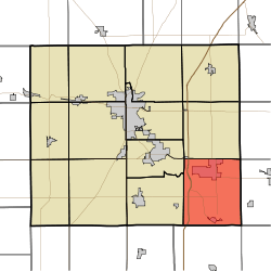 Location of Jefferson Township in Grant County | |
| Coordinates: 40°25′54″N 85°30′13″W / 40.43167°N 85.50361°WCoordinates: 40°25′54″N 85°30′13″W / 40.43167°N 85.50361°W | |
| Country | United States |
| State | Indiana |
| County | Grant |
| Government | |
| • Type | Indiana township |
| Area | |
| • Total | 41.9 sq mi (109 km2) |
| • Land | 41.76 sq mi (108.2 km2) |
| • Water | 0.14 sq mi (0.4 km2) 0.33% |
| Elevation | 899 ft (274 m) |
| Population (2010) | |
| • Total | 5,839 |
| • Density | 139.8/sq mi (54.0/km2) |
| GNIS feature ID | 0453484 |
Jefferson Township is one of thirteen townships in Grant County, Indiana, United States. As of the 2010 census, its population was 5,839 and it contained 1,758 housing units.[1]
History
The Cumberland Covered Bridge was listed on the National Register of Historic Places in 1978.[2]
Geography
According to the 2010 census, the township has a total area of 41.9 square miles (109 km2), of which 41.76 square miles (108.2 km2) (or 99.67%) is land and 0.14 square miles (0.36 km2) (or 0.33%) is water.[1] Lakes in this township include Dollar Lake. The streams of Branch Creek, Cane Run, Crawford Creek, Lake Branch, Mat Run, Round Run and Upland Drain run through this township.
Cities and towns
Adjacent townships
- Monroe Township (north)
- Washington Township, Blackford County (northeast)
- Licking Township, Blackford County (east)
- Washington Township, Delaware County (south)
- Fairmount Township (west)
- Mill Township (northwest)
Cemeteries
The township contains one cemetery, Shiloh.
Major highways
References
- "Jefferson Township, Grant County, Indiana". Geographic Names Information System. United States Geological Survey. Retrieved 2009-09-24.
- United States Census Bureau cartographic boundary files
- 1 2 "Population, Housing Units, Area, and Density: 2010 - County -- County Subdivision and Place -- 2010 Census Summary File 1". United States Census. Retrieved 2013-05-10.
- ↑ National Park Service (2010-07-09). "National Register Information System". National Register of Historic Places. National Park Service.
External links
Municipalities and communities of Grant County, Indiana, United States | ||
|---|---|---|
| Cities | ||
| Towns | ||
| Townships | ||
| CDPs | ||
| Unincorporated communities | ||
| Footnotes | ‡This populated place also has portions in an adjacent county or counties | |
This article is issued from Wikipedia - version of the 9/4/2016. The text is available under the Creative Commons Attribution/Share Alike but additional terms may apply for the media files.