Jasper Township, Camden County, Missouri
| Jasper Township | |
|---|---|
| Township | |
 | |
| Coordinates: 38°09′06″N 092°45′43″W / 38.15167°N 92.76194°WCoordinates: 38°09′06″N 092°45′43″W / 38.15167°N 92.76194°W | |
| Country | United States |
| State | Missouri |
| County | Camden |
| Area | |
| • Total | 54.63 sq mi (141.49 km2) |
| • Land | 40.44 sq mi (104.74 km2) |
| • Water | 14.19 sq mi (36.75 km2) 25.97% |
| Elevation[1] | 715 ft (218 m) |
| Population (2000) | |
| • Total | 5,027 |
| • Density | 124.3/sq mi (48/km2) |
| FIPS code | 29-36476[2] |
| GNIS feature ID | 0766391 |
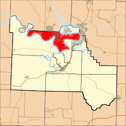
Jasper Township is one of eleven townships in Camden County, Missouri, USA. As of the 2000 census, its population was 5,027.
Jasper Township was established in 1841, and most likely named after William Jasper.[3]
Geography
Jasper Township covers an area of 54.63 square miles (141.5 km2) and contains one incorporated settlement, Sunrise Beach. It contains seven cemeteries: Anderson, Banner, Carver, Rockdale, Shawnee Bend, Stevens Banner and Wilson.
The streams of Brush Creek, Camp Branch and Spring Cove run through this township.
Transportation
Jasper Township contains two airports or landing strips: Mud Harbor Seaplane Base and Tan Tar A Resort Seaplane Base.
References
- ↑ "US Board on Geographic Names". United States Geological Survey. 2007-10-25. Retrieved 2008-01-31.
- ↑ "American FactFinder". United States Census Bureau. Retrieved 2008-01-31.
- ↑ "Camden County Place Names, 1928–1945 (archived)". The State Historical Society of Missouri. Retrieved 8 September 2016.
External links
Municipalities and communities of Camden County, Missouri, United States | ||
|---|---|---|
| Cities | 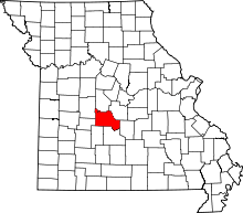 | |
| Villages | ||
| Townships | ||
| CDPs | ||
| Other unincorporated communities | ||
| Footnotes | ‡This populated place also has portions in an adjacent county or counties | |
This article is issued from Wikipedia - version of the 9/8/2016. The text is available under the Creative Commons Attribution/Share Alike but additional terms may apply for the media files.