Jamesburg, New Jersey
| Jamesburg, New Jersey | |
|---|---|
| Borough | |
| Borough of Jamesburg | |
|
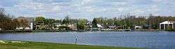
Jamesburg as seen across Lake Manalapan from Thompson County Park | |
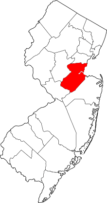
 Jamesburg highlighted in Middlesex County. Inset: Location of Middlesex County in New Jersey. | |
| Coordinates: 40°20′57″N 74°26′25″W / 40.349279°N 74.440405°WCoordinates: 40°20′57″N 74°26′25″W / 40.349279°N 74.440405°W[1][2] | |
| Country |
|
| State |
|
| County | Middlesex |
| Incorporated | March 19, 1887 |
| Named for | James Buckelew |
| Government[3] | |
| • Type | Borough |
| • Body | Borough Council |
| • Mayor | Marlene Lowande (D, term ends December 31, 2019)[4][5] |
| • Administrator | Denise Jawidzik[6] |
| • Clerk | Susan Boulogne (acting)[6] |
| Area[1] | |
| • Total | 0.883 sq mi (2.289 km2) |
| • Land | 0.877 sq mi (2.272 km2) |
| • Water | 0.006 sq mi (0.016 km2) 0.71% |
| Area rank |
518th of 566 in state 25th of 25 in county[1] |
| Elevation[7] | 85 ft (26 m) |
| Population (2010 Census)[8][9][10] | |
| • Total | 5,915 |
| • Estimate (2015)[11] | 6,029 |
| • Rank |
348th of 566 in state 23rd of 25 in county[12] |
| • Density | 6,741.8/sq mi (2,603.0/km2) |
| • Density rank |
68th of 566 in state 5th of 25 in county[12]" |
| Time zone | Eastern (EST) (UTC-5) |
| • Summer (DST) | Eastern (EDT) (UTC-4) |
| ZIP code | 08831[13][14] |
| Area code(s) | 609 and 732[15] |
| FIPS code | 3402334890[1][16][17] |
| GNIS feature ID | 0885263[1][18] |
| Website |
www |
Jamesburg is a borough in Middlesex County, New Jersey, United States. As of the 2010 United States Census, the borough's population was 5,915,[8][9][10] reflecting a decline of 110 (-1.8%) from the 6,025 counted in the 2000 Census, which had in turn increased by 731 (+13.8%) from the 5,294 counted in the 1990 Census.[19]
History
Jamesburg was formed as a borough by an act of the New Jersey Legislature on March 19, 1887, when it was created from portions of Monroe Township, based on the results of a referendum held on March 15, 1887. Jamesburg's incorporation was confirmed on April 15, 1915.[20] The borough was named for James Buckelew, who established a mill that became the nucleus of what became Jamesburg.[21][22][23]
On July 17, 2005, approximately 7 to 8 inches (18 to 20 cm) of rain fell in Jamesburg, flooding areas on West Railroad Avenue, East Church Street, Pergola Avenue, Willow Street, Forsgate Drive, and Gatzmer Avenue. Roughly 75 to 100 families were evacuated from their homes and housed at the John F. Kennedy Elementary School.[24][25]
Geography
According to the United States Census Bureau, the borough had a total area of 0.883 square miles (2.289 km2), including 0.877 square miles (2.272 km2) of land and 0.006 square miles (0.016 km2) of water (0.71%).[1][2]
The borough is the older and more urban core area located in the center of Monroe Township.[26]
Demographics
| Historical population | |||
|---|---|---|---|
| Census | Pop. | %± | |
| 1880 | 681 | — | |
| 1890 | 887 | 30.2% | |
| 1900 | 1,063 | 19.8% | |
| 1910 | 2,075 | 95.2% | |
| 1920 | 2,053 | −1.1% | |
| 1930 | 2,048 | −0.2% | |
| 1940 | 2,128 | 3.9% | |
| 1950 | 2,307 | 8.4% | |
| 1960 | 2,853 | 23.7% | |
| 1970 | 4,584 | 60.7% | |
| 1980 | 4,114 | −10.3% | |
| 1990 | 5,294 | 28.7% | |
| 2000 | 6,025 | 13.8% | |
| 2010 | 5,915 | −1.8% | |
| Est. 2015 | 6,029 | [11][27] | 1.9% |
| Population sources: 1880-1890[28] 1890-1920[29] 1890-1910[30] 1910-1930[31] 1930-1990[32] 2000[33][34] 2010[8][9][10] | |||
2010 Census
At the 2010 United States Census, there were 5,915 people, 2,172 households, and 1,492 families residing in the borough. The population density was 6,741.8 per square mile (2,603.0/km2). There were 2,267 housing units at an average density of 2,583.9 per square mile (997.6/km2). The racial makeup of the borough was 73.90% (4,371) White, 8.84% (523) Black or African American, 0.85% (50) Native American, 4.53% (268) Asian, 0.00% (0) Pacific Islander, 9.42% (557) from other races, and 2.47% (146) from two or more races. Hispanics or Latinos of any race were 22.38% (1,324) of the population.[8]
There were 2,172 households, of which 36.0% had children under the age of 18 living with them, 51.0% were married couples living together, 12.3% had a female householder with no husband present, and 31.3% were non-families. 25.8% of all households were made up of individuals, and 7.1% had someone living alone who was 65 years of age or older. The average household size was 2.72 and the average family size was 3.26.[8]
In the borough, 25.3% of the population were under the age of 18, 8.4% from 18 to 24, 31.7% from 25 to 44, 26.1% from 45 to 64, and 8.5% who were 65 years of age or older. The median age was 35.9 years. For every 100 females there were 102.2 males. For every 100 females age 18 and over, there were 100.7 males.[8]
The Census Bureau's 2006-2010 American Community Survey showed that (in 2010 inflation-adjusted dollars) median household income was $52,169 (with a margin of error of +/- $10,781) and the median family income was $69,531 (+/- $13,862). Males had a median income of $49,615 (+/- $9,412) versus $50,164 (+/- $5,717) for females. The per capita income for the borough was $28,668 (+/- $3,584). About 4.9% of families and 8.1% of the population were below the poverty line, including 5.7% of those under age 18 and 8.8% of those age 65 or over.[35]
2000 Census
As of the 2000 United States Census[16] there were 6,025 people, 2,176 households, and 1,551 families residing in the borough. The population density was 7,148.2 people per square mile (2,769.4/km2). There were 2,240 housing units at an average density of 2,657.6 per square mile (1,029.6/km2). The racial makeup of the borough was 82.82% White, 8.83% African American, 0.20% Native American, 2.22% Asian, 3.80% from other races, and 2.12% from two or more races. Hispanic or Latino of any race were 10.06% of the population.[33][34]
There were 2,176 households out of which 35.4% had children under the age of 18 living with them, 54.7% were married couples living together, 12.1% had a female householder with no husband present, and 28.7% were non-families. 22.4% of all households were made up of individuals and 6.9% had someone living alone who was 65 years of age or older. The average household size was 2.70 and the average family size was 3.18.[33][34]
In the borough the population was spread out with 24.6% under the age of 18, 7.5% from 18 to 24, 35.6% from 25 to 44, 21.5% from 45 to 64, and 10.7% who were 65 years of age or older. The median age was 35 years. For every 100 females there were 95.0 males. For every 100 females age 18 and over, there were 92.7 males.[33][34]
The median income for a household in the borough was $59,461, and the median income for a family was $67,887. Males had a median income of $45,019 versus $33,333 for females. The per capita income for the borough was $23,325. About 3.0% of families and 3.5% of the population were below the poverty line, including 5.1% of those under age 18 and 3.9% of those age 65 or over.[33][34]
Parks and recreation
Thompson Park is located on the south western edge of Jamesburg and is also partially in the neighboring town of Monroe. Thompson Park takes up at total of 675 acres (2.73 km2). The 30-acre (120,000 m2) Manalapan Lake is located on the eastern edge of the park. The park in total has four tennis courts, four basketball courts, two handball courts, three baseball fields, a softball field, many soccer fields, multiple picnic groves equipped with grills, three hiking/biking trails, fishing, animal haven, and a gazebo.[36]
The park has three entrances. Two are located on Perrineville Road, and one is located on Forsgate Drive.
Monroe Township Soccer Club hosts a tournament every year on the soccer fields that are located in the park.
Government
Local government
Jamesburg is governed under the Borough form of New Jersey municipal government. The governing body consists of a Mayor and a Borough Council comprising six council members, with all positions elected at-large on a partisan basis as part of the November general election. A Mayor is elected directly by the voters to a four-year term of office. The Borough Council consists of six members elected to serve three-year terms on a staggered basis, with two seats coming up for election each year in a three-year cycle.[3] The Borough form of government used by Jamesburg, the most common system used in the state, is a "weak mayor / strong council" government in which council members act as the legislative body with the mayor presiding at meetings and voting only in the event of a tie. The mayor can veto ordinances subject to an override by a two-thirds majority vote of the council. The mayor makes committee and liaison assignments for council members, and most appointments are made by the mayor with the advice and consent of the council.[37][38]
As of 2016, the Mayor of the Borough of Jamesburg is Democrat Marlene Lowande, whose term of office ends December 31, 2019. Members of the Borough Council are Council President Daria Ludas (D, 2017), Thomas Busco Jr. (D, 2018), Thomas Gibbons (R, 2016), Colleen Rutsky (D, 2017), Shannon Spillane (R, 2016) and Sandy Sussman (D, 2018).[4][39][40][41][42][43]
Federal, state and county representation
Jamesburg is located in the 12th Congressional District[44] and is part of New Jersey's 14th state legislative district.[9][45][46]
New Jersey's Twelfth Congressional District is represented by Bonnie Watson Coleman (D, Ewing Township).[47] New Jersey is represented in the United States Senate by Cory Booker (D, Newark, term ends 2021)[48] and Bob Menendez (D, Paramus, 2019).[49][50]
For the 2016–2017 session (Senate, General Assembly), the 14th Legislative District of the New Jersey Legislature is represented in the State Senate by Linda R. Greenstein (D, Plainsboro Township) and in the General Assembly by Daniel R. Benson (D, Hamilton Township, Mercer County) and Wayne DeAngelo (D, Hamilton Township).[51] The Governor of New Jersey is Chris Christie (R, Mendham Township).[52] The Lieutenant Governor of New Jersey is Kim Guadagno (R, Monmouth Beach).[53]
Middlesex County is governed by a Board of Chosen Freeholders, whose seven members are elected at-large on a partisan basis to serve three-year terms of office on a staggered basis, with either two or three seats coming up for election each year as part of the November general election. At an annual reorganization meeting held in January, the board selects from among its members a Freeholder Director and Deputy Director. As of 2015, Middlesex County's Freeholders (with party affiliation, term-end year, residence and committee chairmanship listed in parentheses) are Freeholder Director Ronald G. Rios (D, term ends December 31, 2015, Carteret; Ex-officio on all committees),[54] Freeholder Deputy Director Carol Barrett Bellante (D, 2017; Monmouth Junction, South Brunswick Township; County Administration),[55] Kenneth Armwood (D, 2016, Piscataway; Business Development and Education),[56] Charles Kenny ( D, 2016, Woodbridge Township; Finance),[57] H. James Polos (D, 2015, Highland Park; Public Safety and Health),[58] Charles E. Tomaro (D, 2017, Edison; Infrastructure Management)[59] and Blanquita B. Valenti (D, 2016, New Brunswick; Community Services).[60][61] Constitutional officers are County Clerk Elaine M. Flynn (D, Old Bridge Township),[62] Sheriff Mildred S. Scott (D, 2016, Piscataway)[63] and Surrogate Kevin J. Hoagland (D, 2017; New Brunswick).[61][64]
Politics
As of March 23, 2011, there were a total of 2,996 registered voters in Jamesburg, of which 935 (31.2%) were registered as Democrats, 450 (15.0%) were registered as Republicans and 1,611 (53.8%) were registered as Unaffiliated. There were no voters registered to other parties.[65]
In the 2012 presidential election, Democrat Barack Obama received 58.4% of the vote (1,103 cast), ahead of Republican Mitt Romney with 40.1% (757 votes), and other candidates with 1.5% (29 votes), among the 1,906 ballots cast by the borough's 2,998 registered voters (17 ballots were spoiled), for a turnout of 63.6%.[66][67] In the 2008 presidential election, Democrat Barack Obama received 55.7% of the vote (1,172 cast), ahead of Republican John McCain with 42.0% (884 votes) and other candidates with 1.4% (29 votes), among the 2,104 ballots cast by the borough's 3,075 registered voters, for a turnout of 68.4%.[68] In the 2004 presidential election, Democrat John Kerry received 49.3% of the vote (1,017 ballots cast), outpolling Republican George W. Bush with 48.8% (1,006 votes) and other candidates with 0.7% (20 votes), among the 2,061 ballots cast by the borough's 3,036 registered voters, for a turnout percentage of 67.9.[69]
In the 2013 gubernatorial election, Republican Chris Christie received 63.9% of the vote (762 cast), ahead of Democrat Barbara Buono with 34.3% (409 votes), and other candidates with 1.8% (22 votes), among the 1,201 ballots cast by the borough's 3,010 registered voters (8 ballots were spoiled), for a turnout of 39.9%.[70][71] In the 2009 gubernatorial election, Republican Chris Christie received 54.7% of the vote (752 ballots cast), ahead of Democrat Jon Corzine with 35.1% (482 votes), Independent Chris Daggett with 7.9% (108 votes) and other candidates with 1.5% (20 votes), among the 1,374 ballots cast by the borough's 2,952 registered voters, yielding a 46.5% turnout.[72]
Education
The Jamesburg Public Schools serve students in pre-Kindergarten through eighth grade. As of the 2013-14 school year, the district's two schools had an enrollment of 667 students and 47.5 classroom teachers (on an FTE basis), for a student–teacher ratio of 14.0:1.[73] Schools in the district (with 2013-14 enrollment data from the National Center for Education Statistics[74]) are John F. Kennedy Elementary School[75] for grades K-5 (486 students) and Grace M. Breckwedel Middle School[76] for grades 6-8 (181 students).[77][78]
Jamesburg High School, founded in 1905, graduated its last class in June 1979. Since 1980, Jamesburg's high school students attend Monroe Township High School in Monroe Township, as part of a sending/receiving relationship with the Monroe Township School District.[79][80] As of the 2013-14 school year, the school had an enrollment of 1,966 students and 169.7 classroom teachers (on an FTE basis), for a student–teacher ratio of 11.6:1.[81]
With annual tuition costs per student at Monroe Township High School rising past $16,000 as the Monroe district has added debt service costs into their tuition charges, the Jamesburg Public Schools looked for an alternate high school in the area to send students at lower cost, which would have started with the freshman class in 2012-13, though students already enrolled at Monroe Township High School would continue their attendance there until they graduate. The Jamesburg district contacted 18 districts and received interest from high schools in the Freehold Regional High School District, Matawan-Aberdeen Regional School District, Old Bridge Township Public Schools, South Amboy Public Schools and the West Windsor-Plainsboro Regional School District, which had been sent demographic information in July 2011 about the Jamesburg high school population as part of their review process.[82] By October 2011, the district decided to maintain sending students to Monroe Township, as had been done since 1979.[83]
Transportation
Roads and highways
As of May 2010, the borough had a total of 16.53 miles (26.60 km) of roadways, of which 11.67 miles (18.78 km) were maintained by the municipality and 4.86 miles (7.82 km) by Middlesex County.[84]
The only major roads that pass through are solely county routes. They include County Route 522, County Route 612, County Route 615, and County Route 625 (Perrineville Road).
The closest limited access road is the New Jersey Turnpike (Interstate 95) at Exit 8A in surrounding Monroe Township. Route 612 provides a connection between the Turnpike/Route 32 and CR 520.
Public transportation
Middlesex County Area Transit (MCAT) shuttles provide service to and from Jamesburg on several routes across the county.[85]
Notable people
People who were born in, residents of, or otherwise closely associated with Jamesburg include:
- Harrison Woodhull Crosby, in 1847 became the first to can tomatoes.[86]
- Frankie Hayes (1914–1955), catcher in Major League Baseball from 1933-47 who batted and threw right-handed, and played for the Philadelphia Athletics for most of his career.[87]
- George Edward Pendray (1901-1987), space flight proponent.[88]
References
- 1 2 3 4 5 6 2010 Census Gazetteer Files: New Jersey County Subdivisions, United States Census Bureau. Accessed May 21, 2015.
- 1 2 US Gazetteer files: 2010, 2000, and 1990, United States Census Bureau. Accessed September 4, 2014.
- 1 2 2012 New Jersey Legislative District Data Book, Rutgers University Edward J. Bloustein School of Planning and Public Policy, March 2013, p. 165.
- 1 2 Jamesburg Borough Council, Jamesburg Borough. Accessed July 12, 2016.
- ↑ 2016 New Jersey Mayors Directory, New Jersey Department of Community Affairs. Accessed June 14, 2016. As of date accessed, Lowande is listed as mayor with an incorrect term-end year of 2020.
- 1 2 Administration and Staff, Borough of Jamesburg. Accessed July 12, 2016.
- ↑ U.S. Geological Survey Geographic Names Information System: Borough of Jamesburg, Geographic Names Information System. Accessed March 6, 2013.
- 1 2 3 4 5 6 DP-1 - Profile of General Population and Housing Characteristics: 2010 for Jamesburg borough, Bergen County, New Jersey, United States Census Bureau. Accessed April 2, 2012.
- 1 2 3 4 Municipalities Grouped by 2011-2020 Legislative Districts, New Jersey Department of State, p. 7. Accessed January 6, 2013.
- 1 2 3 Table DP-1. Profile of General Demographic Characteristics: 2010 for Jamesburg borough, New Jersey Department of Labor and Workforce Development. Accessed April 2, 2012.
- 1 2 PEPANNRES - Annual Estimates of the Resident Population: April 1, 2010 to July 1, 2015 - 2015 Population Estimates for New Jersey municipalities, United States Census Bureau. Accessed May 22, 2016.
- 1 2 GCT-PH1 Population, Housing Units, Area, and Density: 2010 - State -- County Subdivision from the 2010 Census Summary File 1 for New Jersey, United States Census Bureau. Accessed November 23, 2012.
- ↑ Look Up a ZIP Code for Jamesburg, NJ, United States Postal Service. Accessed November 23, 2012.
- ↑ Zip Codes, State of New Jersey. Accessed August 28, 2013.
- ↑ Area Code Lookup - NPA NXX for Jamesburg, NJ, Area-Codes.com. Accessed August 28, 2013.
- 1 2 American FactFinder, United States Census Bureau. Accessed September 4, 2014.
- ↑ A Cure for the Common Codes: New Jersey, Missouri Census Data Center. Accessed November 26, 2012.
- ↑ US Board on Geographic Names, United States Geological Survey. Accessed September 4, 2014.
- ↑ Table 7. Population for the Counties and Municipalities in New Jersey: 1990, 2000 and 2010, New Jersey Department of Labor and Workforce Development, February 2011. Accessed November 23, 2012.
- ↑ Snyder, John P. The Story of New Jersey's Civil Boundaries: 1606-1968, Bureau of Geology and Topography; Trenton, New Jersey; 1969. p. 170. Accessed April 2, 2012.
- ↑ A Profile of Jamesburg's History, The Jamesburg Historical Association. Accessed July 24, 2014.
- ↑ Hutchinson, Viola L. The Origin of New Jersey Place Names, New Jersey Public Library Commission, May 1945. Accessed September 2, 2015.
- ↑ Jamesburg's History, Borough of Jamesburg. Accessed September 2, 2015. "Jamesburg is a 0.9 square mile town, incorporated in 1887. It was named after James Buckelew, a very influential man in Jamesburg's history."
- ↑ Rebuilding Downtown Jamesburg: Life After the Flood, Jamesburg.net. Accessed January 28, 2012.
- ↑ Council Minutes, Borough of Jamesburg, September 28, 2005. Accessed January 28, 2012.
- ↑ Areas touching Jamesburg, MapIt. Accessed June 1, 2015.
- ↑ Census Estimates for New Jersey April 1, 2010 to July 1, 2015, United States Census Bureau. Accessed May 22, 2016.
- ↑ "United States Census 1890: Minor Civil Divisions Mississippi - Ohio, United States Census Bureau. Accessed July 10, 2016.
- ↑ Compendium of censuses 1726-1905: together with the tabulated returns of 1905, New Jersey Department of State, 1906. Accessed October 16, 2013.
- ↑ Porter, Robert Percival. Preliminary Results as Contained in the Eleventh Census Bulletins: Volume III - 51 to 75, p. 98. United States Census Bureau, 1890. Accessed November 23, 2012.
- ↑ Fifteenth Census of the United States : 1930 - Population Volume I, United States Census Bureau, p. 717. Accessed April 2, 2012. A population of 1,566 is shown for 1910, in conflict with the 2,075 listed in the 1910 Census.
- ↑ Table 6. New Jersey Resident Population by Municipality: 1930 - 1990, New Jersey Department of Labor and Workforce Development. Accessed June 28, 2015.
- 1 2 3 4 5 Census 2000 Profiles of Demographic / Social / Economic / Housing Characteristics for Jamesburg borough, New Jersey, United States Census Bureau. Accessed April 2, 2012.
- 1 2 3 4 5 DP-1: Profile of General Demographic Characteristics: 2000 - Census 2000 Summary File 1 (SF 1) 100-Percent Data for Jamesburg borough, Middlesex County, New Jersey, United States Census Bureau. Accessed November 23, 2012.
- ↑ DP03: Selected Economic Characteristics from the 2006-2010 American Community Survey 5-Year Estimates for Jamesburg borough, Middlesex County, New Jersey, United States Census Bureau. Accessed April 2, 2012.
- ↑ Middlesex County, NJ - Parks and Recreation Accessed July 28, 2008 .
- ↑ Cerra, Michael F. "Forms of Government: Everything You've Always Wanted to Know, But Were Afraid to Ask", New Jersey State League of Municipalities. Accessed November 30, 2014.
- ↑ "Forms of Municipal Government in New Jersey", p. 6. Rutgers University Center for Government Studies. Accessed June 3, 2015.
- ↑ 2016 Municipal User Friendly Budget, Jamesburg Borough. Accessed July 12, 2016.
- ↑ Borough of Carteret, Middlesex County, New Jersey. Accessed July 12, 2016.
- ↑ November 3, 2015 General Election Results, Middlesex County, New Jersey. Accessed July 12, 2016.
- ↑ November 4, 2014 General Election Results, Middlesex County, New Jersey. Accessed July 12, 2016.
- ↑ November 5, 2013 General Election Results, Middlesex County, New Jersey. Accessed July 12, 2016.
- ↑ Plan Components Report, New Jersey Redistricting Commission, December 23, 2011. Accessed January 6, 2013.
- ↑ 2016 New Jersey Citizen's Guide to Government, p. 59, New Jersey League of Women Voters. Accessed July 20, 2016.
- ↑ Districts by Number for 2011-2020, New Jersey Legislature. Accessed January 6, 2013.
- ↑ Bonnie Watson Coleman Biography, United States House of Representatives. Accessed January 7, 2015.
- ↑ About Cory Booker, United States Senate. Accessed January 26, 2015. "He now owns a home and lives in Newark's Central Ward community."
- ↑ Biography of Bob Menendez, United States Senate, January 26, 2015. "He currently lives in Paramus and has two children, Alicia and Robert."
- ↑ Senators of the 114th Congress from New Jersey. United States Senate. Accessed January 26, 2015. "Booker, Cory A. - (D - NJ) Class II; Menendez, Robert - (D - NJ) Class I"
- ↑ Legislative Roster 2016-2017 Session, New Jersey Legislature. Accessed January 17, 2016.
- ↑ "About the Governor". State of New Jersey. Retrieved 2010-01-21.
- ↑ "About the Lieutenant Governor". State of New Jersey. Retrieved 2010-01-21.
- ↑ Ronald G. Rios, Middlesex County, New Jersey. Accessed January 11, 2015.
- ↑ Carol Barrett Bellante, Middlesex County, New Jersey. Accessed January 11, 2015.
- ↑ Kenneth Armwood, Middlesex County, New Jersey. Accessed January 11, 2015.
- ↑ Charles Kenny, Middlesex County, New Jersey. Accessed January 11, 2015.
- ↑ H. James Polos, Middlesex County, New Jersey. Accessed January 11, 2015.
- ↑ Charles E. Tomaro, Middlesex County, New Jersey. Accessed January 11, 2015.
- ↑ Blanquita B. Valenti, Middlesex County, New Jersey. Accessed January 11, 2015.
- 1 2 Elected County Officials, Middlesex County, New Jersey. Accessed January 11, 2015.
- ↑ County Clerk Elaine Flynn, Middlesex County, New Jersey. Accessed January 11, 2015.
- ↑ Sheriff Mildred S. Scott, Middlesex County, New Jersey. Accessed January 11, 2015.
- ↑ Surrogate Kevin J. Hoagland, Middlesex County, New Jersey. Accessed January 11, 2015.
- ↑ Voter Registration Summary - Middlesex, New Jersey Department of State Division of Elections, March 23, 2011. Accessed November 23, 2012.
- ↑ "Presidential General Election Results - November 6, 2012 - Middlesex County" (PDF). New Jersey Department of Elections. March 15, 2013. Retrieved December 24, 2014.
- ↑ "Number of Registered Voters and Ballots Cast - November 6, 2012 - General Election Results - Middlesex County" (PDF). New Jersey Department of Elections. March 15, 2013. Retrieved December 24, 2014.
- ↑ 2008 Presidential General Election Results: Middlesex County, New Jersey Department of State Division of Elections, December 23, 2008. Accessed November 23, 2012.
- ↑ 2004 Presidential Election: Middlesex County, New Jersey Department of State Division of Elections, December 13, 2004. Accessed November 23, 2012.
- ↑ "Governor - Middlesex County" (PDF). New Jersey Department of Elections. January 29, 2014. Retrieved December 24, 2014.
- ↑ "Number of Registered Voters and Ballots Cast - November 5, 2013 - General Election Results - Middlesex County" (PDF). New Jersey Department of Elections. January 29, 2014. Retrieved December 24, 2014.
- ↑ 2009 Governor: Middlesex County, New Jersey Department of State Division of Elections, December 31, 2009. Accessed November 23, 2012.
- ↑ District information for Jamesburg School District, National Center for Education Statistics. Accessed November 2, 2016.
- ↑ School Data for the Jamesburg Public Schools, National Center for Education Statistics. Accessed December 2, 2016.
- ↑ John F. Kennedy Elementary School, Jamesburg Public Schools. Accessed October 12, 2014.
- ↑ Grace M. Breckwedel Middle School, Jamesburg Public Schools. Accessed October 12, 2014.
- ↑ Schools, Jamesburg Public Schools. Accessed October 12, 2014.
- ↑ New Jersey School Directory for the Jamesburg Public Schools, New Jersey Department of Education. Accessed October 12, 2014.
- ↑ Cheslow, Jerry. "A Townful of Empty Nesters", The New York Times, October 14, 2007. Accessed August 8, 2008. "In addition to the four elementary schools, the Applegarth Middle School teaches Grades 7 and 8, and the 1,400-student Monroe Township High School covers Grades 9 through 12. It is shared with the borough of Jamesburg, the 'hole in the doughnut' municipality in the center of the township."
- ↑ Monroe Township High School 2015 Report Card Narrative, New Jersey Department of Education. Accessed May 30, 2016. "Monroe Township High School is centrally located within a forty-three square mile suburban community in Southern Middlesex County. Originally opened on Perrineville Road in 1973, our high school became a receiving school for approximately 300 high school age students from neighboring Jamesburg in 1980."
- ↑ School Data for Monroe Township High School, National Center for Education Statistics. Accessed May 30, 2016.
- ↑ Haberstroh, Christina. "Five High Schools Consider taking Jamesburg Students, The Sentinel, July 7, 2011. Accessed JOctober 12, 2014.
- ↑ Staff. "Jamesburg students will remain at Monroe H.S.", News Transcript, October 26, 2011. Accessed November 2, 2016. "The Jamesburg board had set an Oct. 1 deadline for interested districts to respond. The board would have then conducted a feasibility study before choosing a new high school for its students. Instead, Jamesburg will continue the send-receive relationship it has had with Monroe Township since 1979."
- ↑ Middlesex County Mileage by Municipality and Jurisdiction, New Jersey Department of Transportation, May 2010. Accessed July 24, 2014.
- ↑ Middlesex County Area Transit (MCAT) Shuttle Routes, Middlesex County. Accessed July 24, 2014.
- ↑ A Walking Tour of Jamesburg, Jamesburg.net. Accessed April 8, 2007. "In 1847, tomatoes were first canned in tin cans by Harrison Woodhull Crosby, a Lafayette Professor, in the Buckelew Cannery."
- ↑ Frankie Hayes All-Star Stats, Baseball Almanac. Accessed June 8, 2007.
- ↑ Neuffer, Elizabeth. "G. E. PENDRAY, 86, ROCKET PROPONENT", The New York Times, September 20, 1987. Accessed July 5, 2012. "G. Edward Pendray, a proponent of the peaceful uses of rocket power and space flight since the 1930's, died of complications from Parkinson's disease Tuesday. He was 86 years old and lived in Jamesburg, N.J."
External links
| Wikimedia Commons has media related to Jamesburg, New Jersey. |
- Jamesburg Borough website
- Middlesex County web page for Jamesburg
- Jamesburg Public Schools
- Jamesburg Public Schools's 2014–15 School Report Card from the New Jersey Department of Education
- School Data for the Jamesburg Public Schools, National Center for Education Statistics
- The Jamesburg Historical Association
- Jamesburg Flood information