Jagatsinghpur district
| Jagatsinghpur ଜଗତସିଂହପୁର ଜିଲ୍ଲା | |
|---|---|
| District | |
| Nickname(s): Banikshetra | |
 Location in Odisha, India | |
| Coordinates: 20°15′58″N 86°09′58″E / 20.266°N 86.166°ECoordinates: 20°15′58″N 86°09′58″E / 20.266°N 86.166°E | |
| Country |
|
| State | Odisha |
| Headquarters | Jagatsinghpur |
| Government | |
| • Collector | Dr. Bijay Ketan Upadhyaya, I.A.S. |
| • Member of Parliament | Dr. Kulamani Samal, BJD |
| Area | |
| • Total | 1,759 km2 (679 sq mi) |
| Elevation | 559.31 m (1,835.01 ft) |
| Population (2001) | |
| • Total | 1,058,894 |
| • Density | 602/km2 (1,560/sq mi) |
| Languages | |
| • Official | Odia, English |
| Time zone | IST (UTC+5:30) |
| PIN | 754103 |
| Vehicle registration | OD-21 |
| Sex ratio | 1.038 ♂/♀ |
| Literacy | 87.1% |
| Lok Sabha constituency | Jagatsinghpur |
| Vidhan Sabha constituency | 5 |
| Climate | Aw (Köppen) |
| Precipitation | 1,501.3 millimetres (59.11 in) |
| Website |
jagatsinghpur |
Jagatsinghpur District is one of the thirty districts of Odisha in the eastern coast of India. The city of Jagatsinghpur is the district headquarters. It is the smallest district in the state and covers a landmass of 1759 km2. With 88.5% rate of male literacy and 68.5% of female literacy, the district ranks better than the national average in literacy and is one of the developed districts in Odisha. The district tops the list in male literacy in Odisha.[1]
History
History of Jagatsinghpur comprises the conglomeration of Hindu, Muslim, Maratha and British realms. The Maratha administration kept the place under their jurisdiction and appointed Jagat Singh in 1748 to collect revenue. He collected the peshkush and Nazrana and remained an unchallenged and uninterrupted administrator for a pretty long period. The place was converted from Hariharpur to Jagatsinghpur after the name of Jagat Singh since 1786. Consequent to the bifurcation of old Cuttack District into four new districts, the Jagatsinghpur District was created on 1 April 1993. The new district was inaugurated by the then Chief Minister Biju Patnaik in an auspicious ceremony. The foundation stone to the District Collectorate was laid in November 1995 by the then Deputy Chief Minister Basant Kumar Biswal and it was inaugurated in November 1997.
Geography
Jagatsinghpur is situated on an elevation of 15 metres (49 feet). It is the smallest district in the state and covers a landmass of 1759 km2. The place lies between 8603' to 86045' East Longitude and between 19058' to 20023' North latitude. It is bounded by Kendrapara district in North, Puri district in the South, Bay of Bengal in the East and Cuttack district in the West. It enjoys a temperate climate. Winter is cold, while summer is hot and humid. Four major rivers of Odisha irrigate the mainland of Jagatsinghpur. These are the Mahanadi, Kathajodi, Devi and Biluakhai. The district is prone to cyclonic rainfalls during the monsoons. The cyclone of 1999 caused maximum damage in this district.
Economy
The economy of the Jagatsinghpur district is dependent on agriculture. Agriculture is the main occupation of bulk of the population. The key crops of the district are paddy, sugarcane, turmeric, cotton and jute. Processing, manufacturing, reparing and fisheries industries also contribute towards the economic development. Jagatsinghpur is a leading district of the state in terms of industrialization. Paradip, a modern deep water port, was built here in the 1960s and has now become a hot business destination due to the large foreign direct investment. The port town of the district has already emerged as the one of the country’s major investment hot spot by attracting investment in excess of the tune of 3.5 lakh crores (US $68.84 billion) including the Rs 2, 74,134 crore Petroleum Chemicals and Petrochemical Investment Region (PCPIR) which has spread over 284 square kilometres (110 sq mi) in the area.[2] IOC has already installed a 15 MMTPA refinery cum petrochemical complex at Paradip. Indian Railways has also taken up the Paradeep-Haridaspur 82 km broad gauge line to boost the infrastructure in the region. Up-gradation of NH-5(A) is also going on in a very fast rate. A new all green field road will also be built from Bhubaneswar to Paradip.[3]
The following Large and Medium sector industries exist in the district.
- Paradeep Phosphates Limited, a fertilizer company
- Paradeep Plastic Park Limited
- IFFCO- Fertilizer Plant
- Essar Steel's Pellet plant
- Indian Oil marketing terminal
- Indian Oil Corporation Limited (IOCL) Refinery
- Bharat Petroleum Corp. Ltd. marketing terminal
- Hindustan Petroleum Corp. Ltd. marketing terminal.
- Cargill's edible oil plant
- Skol Breweries Ltd. ( Unit-East Coast Brewery)
Education
The district has a total number of 1456 primary schools, 661 Upper primary schools and 324 Secondary schools. In addition to these the district has 35 Junior colleges and 18 Degree colleges. The prominent among them is the SVM Autonomous College. This was established in the year 1963. It offers undergraduate courses in Arts, Science and Commerce and undergraduate Self Financial Courses such as BBA & BCA.[4]
Divisions
This district was subdivided into 8 Tehsils,they are Jagatsinghpur, Kujang, Tirtol, Balikuda, Biridi, Naugaon, Ersama and Raghunathpur. The last four are new tehsils created in 2008.
Demographics
According to the 2011 census Jagatsinghpur district has a population of 1,136,971,[5] roughly equal to the nation of Cyprus[6] or the US state of Rhode Island.[7] This gives it a ranking of 410th in India (out of a total of 640). The district has a population density of 682 inhabitants per square kilometre (1,770/sq mi). Its population growth rate over the decade 2001-2011 was only 7.5%. Jagatsinghapur has a sex ratio of 968 females for every 1000 males, and a average literacy of 86.59%.[8]
Culture
Jagatsinghpur is also famous for the Sarala Temple and is well known as the cultural heart of Odisha. Sarala Das was a 15th-century poet and scholar of Odia literature, best known for three Odia books — Mahabharata, Vilanka Ramayana and Chandi Purana was born at Kanakavati Patana, known as Kanakapura, one of the Sidhikshetras in Jagatsinghpur district. As an originator of Odia literature, his work has formed an enduring source of information for succeeding generations. The district, smallest in size among the 30 districts in Odisha, has produced some of the most famous names in Oriya. Notable among them are listed below.
- Academicians and Scientists: Prana Krushna Parija, Sriram Chandra Dash, Manoranjan Mohanty, Abani Kumar Baral, Amitav Acharya
- Writers and poets: Birakisore Das, Gopal Chhotray, Pratibha Ray, Bibhuti Patnaik, Hrudananda Ray, Chittaranjan Das, Devdas Chhotray
- Freedom fighters, Politicians and Leaders: Nabakrushna Choudhuri, Malati Choudhury, Nityanand Kanungo, Sarala Devi
The District is also famous for having theatre groups which keep the old tradition of live acting before a crowd. The groups have become the part of mainstream entertainment for people all over Odisha. Parbati Gannatya, Benirampur opera, Gouri Gananatya, Tulasi Gananatya, Durgashree Gananatya, Tarapur Opera and Trinath Gananatya are some of the famous theatre groups of Jagatsinghpur district.
Transportation
The railway line from Cuttack links Paradip. The nearest railway station from Jagatsinghpur town is Gorakhnath Station which is about 10 km from Jagatsinghpur.[9] Train service is not frequent; it is better to go by road. Nearest airport is Biju Patnaik International Airport at Bhubaneswar. Charter air service from Biju Patnaik International Airport to Paradip is provided by Pawan Hans. Jagatsinghpur is well connected with other cities via road. Ministry of Road Transport and Highways, Government of India has decided to link Jagatsinghpur with a new national highway.[10] There is frequent bus services to Jagatsinghpur form Bhubaneswar, Cuttack, Paradip, Machhagaon, Naugaon, Naharana, Baharana, Tandikul, Katara, Sidhala, Rourkela, Puri, Kakatapur, Balasore, Bhadrak and all other important cities in Odisha. Jagatsinghpur is situated at 40 km from Cuttack and 60 km from Bhubaneswar.
Places to visit
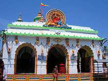
- Sarala Pitha (Jhankad):Jhankad is the sanctum sanctorum of Goddess Sarala, regarded as one of the most spiritually elevated expressions of Shaktism. Believed as a synthesis of divine figure of Durga and Saraswati, the culture of Sarala is an amalgamation of three principal Hindu cults namely Vedic, Tantrik and Vaishnavite. It is one of the eight most famous Shakta shrines of Odisha. It is also associated with the first epic poet of Odisha, Adikavi Sarala Dasa of 15th Century AD.
- Gorakhnath Temple: Gorakhnath Temple is of among the famous Lord Shiva Shrines in Odisha.
- Paradip: It is a major sea port of India for trade activities. The enchanting beauty of the sea, a wonderful sea beach & marine drive, beautiful creeks, estuaries and evergreen forests of estuarine islands of the river Mahanadi, make the place a major tourist attraction.
- Gada Kujanga: Famous for its presiding deity Kunja Behari, Garh Kujanga is also known as Subhadra Kshetra, The Raghunath Jew Matha located near the temple of Kunja Behari is an added attraction of this place.
- Chandapur: At the end of the Village Mahilo in a typical rural atmosphere, the famous temple complex of Lord Raghunath Jew and Lord Chandrasekhar stands around 30 years back. One can find a rare combination of Sri Ram known as Raghunath Jew and Lord Siva known as Chandrasekhar in a single compound.
- Jagatsinghpur: Alaka Ashram, better known as the Shabarmati of Odisha is located here. Temples, beaches and sculptures of historic importance are the major drivers behind tourist influx to Jagatsinghpur. The Somanath temple is famous for the Shiva Shrine. The Shiva Linga was placed by Sri Muchukunda Swami and hence the image is popularly called as Muchukunda Somanath.
- Salajanga Ashram, which is nearly 7 km from Naugaon hat.
- Siali beach is about 20 km from Balikuda block is the most attracting beach of Jagatsinghpur district. It is a very good spot for picnic and can be visited during any seasons of a year.[11]
- Tulasi gadi temple which is at Diasahi, approx 6 km from Jagatsinghpur towards Balikuda is another place of attraction for public or family parties.
- Jagannath temple in Ambasal (approximately 2 km from Balikuda Block) is considered as one of the oldest temples.
- Kunja Bihari Temple in Sadeipur which is about 9 km from Jagatsinghpur.
- Sidha Baranga Pitha is located at Punanga, just 2 km from Jagatsinghpur town. It is famous for temples of Lord Janannath and Lord Hanuman. It is a good picnic spot.
Politics
Vidhan sabha constituencies
The following is the 4 Vidhan sabha constituencies[12][13] of Jagatsinghpur district and the elected members[14] of those places.
| No. | Constituency | Reservation | Extent of the Assembly Constituency (Blocks) | Member of 14th Assembly | Party |
|---|---|---|---|---|---|
| 101 | Paradeep | None | Paradeep (M), Kujang, Tirtol (part) | Damodara Rout | BJD |
| 102 | Tirtol | SC | Biridi, Raghunathpur, Tirtol (part) | Rajashri Mallick | BJD |
| 103 | Balikuda-Erasama | None | Balikuda, Erasama | Prasanta Kumar Muduli | BJD |
| 104 | Jagatsinghpur | None | Jagatsinghpur (M), Jagatsinghpur, Naugaon | Chiranjibi Biswal | Cong |
References
- ↑ Census 2011. "Jagatsinghpur census data 2011". Retrieved 2016-04-28.
- ↑ Business Standard. "PM inaugurates Indian Oil's Paradip refinery". Retrieved 2016-04-28.
- ↑ Ministry of MSME, Govt. of India. "Comprehensive District Plan for Jagatsinghpur" (PDF). Retrieved 2016-04-28.
- ↑ S.V.M. College. "S.V.M. Autonomous College, Jagatsinghpur". Retrieved 2016-04-28.
- ↑ Census 2011. "Jagatsinghpur census data 2011". Retrieved 2016-04-28.
- ↑ CIA, US Directorate of Intelligence, Country Comparison:Population https://www.cia.gov/library/publications/the-world-factbook/rankorder/2119rank.html | accessdate = 2011-10-01
- ↑ "2010 Resident Population Data". U. S. Census Bureau. Retrieved 2011-09-30.
- ↑ Census 2011. "Jagatsinghpur census data 2011". Retrieved 2016-04-28.
- ↑ Indian Rail. "Indian Rail Info". Retrieved 2016-05-03.
- ↑ The Economic Times. "Centre accords National Highway status to 2,000 km roads in Odisha". Retrieved 2016-05-03.
- ↑ "Funds Lacking to Promote Siali Beach as Tourist Destination". The New Indian Express. 23 Dec 2014.
- ↑ Assembly Constituencies and their EXtent
- ↑ Seats of Odisha
- ↑ "List of Member in Fourteenth Assembly". ws.ori.nic.in. Retrieved 19 February 2013.
External links
 |
Kendrapara district | | ||
| Cuttack district | |
Bay of Bengal | ||
| ||||
| | ||||
| Puri district |
| Governance |
|  |
|---|---|---|
| Topics | ||
| GI Products | ||
| Districts | ||
| Cities | ||