Jackson Township, Andrew County, Missouri
| Jackson Township | |
|---|---|
| Township | |
 | |
| Coordinates: 40°00′46″N 094°57′31″W / 40.01278°N 94.95861°WCoordinates: 40°00′46″N 094°57′31″W / 40.01278°N 94.95861°W | |
| Country | United States |
| State | Missouri |
| County | Andrew |
| Area | |
| • Total | 34.70 sq mi (89.88 km2) |
| • Land | 34.65 sq mi (89.75 km2) |
| • Water | 0.05 sq mi (0.12 km2) 0.14% |
| Elevation[1] | 906 ft (276 m) |
| Population (2010) | |
| • Total | 620 |
| • Density | 18/sq mi (6.9/km2) |
| FIPS code | 29-35576[2] |
| GNIS feature ID | 0766223 |
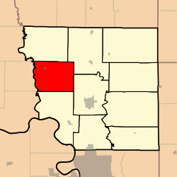
Jackson Township is one of ten townships in Andrew County, Missouri, United States. As of the 2010 census, its population was 620.[3]
Jackson Township was organized in 1846, and named after an early settler.[4]
Geography
Jackson Township covers an area of 34.7 square miles (89.9 km2) and contains one incorporated settlement, Fillmore. It contains three cemeteries: Clizer, Gillispie and Jackson.
Transportation
Jackson Township contains one airport, Cole Landing Strip.
References
- ↑ "US Board on Geographic Names". United States Geological Survey. 2007-10-25. Retrieved 2008-01-31.
- ↑ "American FactFinder". United States Census Bureau. Archived from the original on September 11, 2013. Retrieved 2008-01-31.
- ↑ "Geographic Identifiers: 2010 Demographic Profile Data (G001): Jackson township, Andrew County, Missouri". U.S. Census Bureau, American Factfinder. Retrieved June 21, 2013.
- ↑ "Andrew County Place Names, 1928-1945 (archived)". The State Historical Society of Missouri. Retrieved 30 August 2016.
External links
Municipalities and communities of Andrew County, Missouri, United States | ||
|---|---|---|
| Cities | 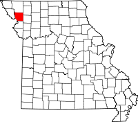 | |
| Villages | ||
| Townships | ||
| Unincorporated communities | ||
| Ghost towns | ||
This article is issued from Wikipedia - version of the 9/10/2016. The text is available under the Creative Commons Attribution/Share Alike but additional terms may apply for the media files.