Ixtlán del Río

Ixtlán del Río is both a municipality and municipal seat in the Mexican state of Nayarit. In 1995 the population of the municipality was 26,137 (21,474 in the municipal seat) and the total area was 581.4 km².
The name of Ixtlán is of náhuatl origin, composed of the words “Itz-tli” meaning obsidian, and “tlán”, meaning place where it is found. So the name means "place where obsidian is found", or "place of the obsidian knife."
Ixlán, as it is known to locals, is located 149 kilometers south of the state capital Tepic and is connected to that city and Guadalajara by both rail and highway connections. The important coastal highway Route 15 passes through the city, while a toll road passes to the east.
Ixlán has boundaries with the municipalities of La Yesca and Jala in the north; Amatlán de Cañas and the state of Jalisco in the south, Jalisco in the east and Ahuacatlán in the west.
The land is mainly mountainous (60%) with some flat lands near the small rivers where the agricultural lands and settlements are located. The climate is hot and sub-humid with rains falling from March to July. The average annual temperature varies between 21 °C and 25 °C, with maximum lows of 0 °C and highs of 48 °C. The average annual rainfall is around 859.8 mm.
The economy is based on services, due to the town's location on the important Mexico-Nogales highway, small industries (brickworks, furniture, pottery), and agriculture. The main crops are maize, sorghum, beans, and green chile. There were about 36,000 head of cattle in 1995.
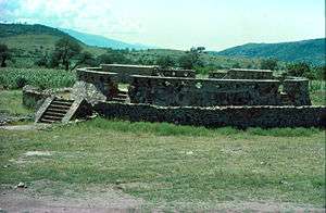
South of the city lies Toriles, the most important archaeological site in northwestern Mexico. Here is found the temple of Quetzalcoatl, from the Toltec culture. The ceramic and gold jewelry extracted here can be seen in the Regional Museum of Ixtlán.[1]
The important Río Grande de Santiago (also called Rio Santiago) crosses the eastern edge of the municipality.
Climate
| Climate data for Ixtlán del Río | |||||||||||||
|---|---|---|---|---|---|---|---|---|---|---|---|---|---|
| Month | Jan | Feb | Mar | Apr | May | Jun | Jul | Aug | Sep | Oct | Nov | Dec | Year |
| Average high °C (°F) | 29.2 (84.6) |
30 (86) |
32.1 (89.8) |
34.4 (93.9) |
35.4 (95.7) |
34.5 (94.1) |
32.6 (90.7) |
32.4 (90.3) |
32 (89.6) |
32 (89.6) |
31.2 (88.2) |
29.3 (84.7) |
32.1 (89.8) |
| Average low °C (°F) | 6.5 (43.7) |
6.6 (43.9) |
7.7 (45.9) |
9.7 (49.5) |
12.6 (54.7) |
15.7 (60.3) |
16.6 (61.9) |
16.7 (62.1) |
16.2 (61.2) |
14.7 (58.5) |
10.6 (51.1) |
8 (46) |
11.8 (53.2) |
| Average precipitation mm (inches) | 18 (0.7) |
10 (0.4) |
5 (0.2) |
5 (0.2) |
13 (0.5) |
160 (6.3) |
241 (9.5) |
221 (8.7) |
147 (5.8) |
50 (2) |
10 (0.4) |
13 (0.5) |
892 (35.1) |
| Source: Weatherbase [2] | |||||||||||||
Notes
- ↑ "Zona Arqueológica los Toriles". Archived from the original on 2007-09-27. Retrieved 2007-12-01.
- ↑ "Weatherbase: Historical Weather for Ixtlán del Río, Nayarit". Weatherbase. 2011. Retrieved on November 24, 2011.
Coordinates: 21°02′N 104°22′W / 21.03°N 104.37°W
