Ittoqqortoormiit
| Ittoqqortoormiit Illoqqortormiut (West Greenlandic) Scoresbysund (Danish) | |
|---|---|
|
Ittoqqortoormiit | |
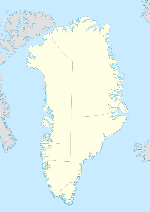 Ittoqqortoormiit Location within Greenland | |
| Coordinates: 70°29′07″N 21°58′00″W / 70.48528°N 21.96667°WCoordinates: 70°29′07″N 21°58′00″W / 70.48528°N 21.96667°W | |
| State |
|
| Constituent country |
|
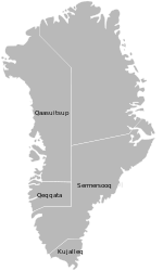
| Municipality |
|
| Founded | 1925 |
| Population (2013) | |
| • Total | 452[1] |
| Time zone | UTC-01 |
| Postal code | 3980 |

Ittoqqortoormiit (East Greenlandic) or Illoqortormiut (West Greenlandic) (Inuit pronunciation: [itːoqːɔʁtɔːʁmiːt]), formerly known as Scoresbysund, is a settlement in the Sermersooq municipality in eastern Greenland. Its population is 452 as of 2013.[1]
The former name Scoresbysund derives from the Arctic explorer and whaler William Scoresby, who was the first to map the area in 1822. The name "Ittoqqortoormiit" means "Big-House Dwellers" in the Eastern Greenlandic dialect. The region is known for its wildlife, including polar bears, muskoxen, and seals.
Geography
Ittoqqortoormiit is located on Liverpool Land, near the mouth of the northern shore of the Kangertittivaq fjord, which empties into the Greenland Sea.[2]
History

Ittoqqortoormiit was founded in 1925 by Ejnar Mikkelsen and some 80 Inuit settlers (70 persons from Tasiilaq and four families from western Greenland). They were brought on the ship Gustav Holm and settled 400 kilometres (249 miles) south of the last known Inuit settlement in northeastern Greenland (Eskimonæs at Dødemandsbugten on the south coast of Clavering Ø, 27 km (17 miles) southwest of later Daneborg, 1823).
The settlement was encouraged by the colonial power Denmark which at the time had a growing interest in Northeast Greenland. At the same time, the colonization was intended to improve declining living conditions in Tasiilaq, from where the settlers were more or less voluntarily transferred. The settlers soon prospered on the good hunting conditions of the new area, which was rich in seals, walruses, narwhals, polar bears and Arctic foxes.
Before that, however, the area itself had been home to a dense population of Inuit in the past, as testified by ruins and other archeological remains.
Ittoqqortoormiit Municipality was a former municipality of Greenland. It is now part of Sermersooq Municipality.
Transport

Ittoqqortoormiit is one of the most remote towns in Greenland. It is served by Ittoqqortoormiit Heliport, with Air Greenland helicopters shuttling passengers between the settlement and Nerlerit Inaat Airport (38 km (24 mi) distance), with boat transfer also possible for a few months a year. In the summer, there are two Air Iceland weekly departures from Reykjavík to Nerlerit Inaat, most of the year only one flight to Iceland a week. Air Greenland has weekly flights from Kangerlussuaq and Nuuk.
Economy
Local hunters have made a living from whale and polar bear hunting for generations, and it remains, up to the present, a significant cultural-economical factor in the area. Flesh and by-products play a direct part in the economy of the hunting families. Income is gained by trading these products, but these options are seasonal and variable.
Ittoqqortoormiit lies near large populations of shrimp and Greenland halibut, but the presence of sea ice prevents the exploitation of these resources year-round, and as a result fishing has never been extensively developed in the municipality.
Tourism, on the other hand, is growing in importance. The buildings at the abandoned Uunarteq settlement are used by the local inhabitants as cottages during summer.
International relations
Twin towns – Sister cities
Ittoqqortoormiit is twinned with:
Climate
Ittoqqortoormiit features a tundra climate (Köppen ET) with bitterly cold winters, chilly summers and no monthly average even close to the 10 °C threshold that would allow tree growth. In fact with a warmest monthly average of only 3 °C Ittoqqortoormiit is closer to the 0 °C threshold for an ice cap climate than a subarctic classification, this coupled with an average annual temperature of -8.6 °C makes Ittoqqortoormiit one of the coldest permanently inhabited locations on Earth.
| Climate data for Ittoqqortoormiit, Greenland (1981–2010) | |||||||||||||
|---|---|---|---|---|---|---|---|---|---|---|---|---|---|
| Month | Jan | Feb | Mar | Apr | May | Jun | Jul | Aug | Sep | Oct | Nov | Dec | Year |
| Average high °C (°F) | −13 (9) |
−14 (7) |
−14 (7) |
−8 (18) |
−2 (28) |
3 (37) |
6 (43) |
5 (41) |
1 (34) |
−6 (21) |
−11 (12) |
−12 (10) |
−5.4 (22.3) |
| Daily mean °C (°F) | −17.5 (0.5) |
−18.5 (−1.3) |
−18 (0) |
−12.5 (9.5) |
−5 (23) |
0.5 (32.9) |
3 (37) |
2.5 (36.5) |
−1.5 (29.3) |
−8 (18) |
−14 (7) |
−16 (3) |
−8.6 (16.5) |
| Average low °C (°F) | −22 (−8) |
−23 (−9) |
−22 (−8) |
−17 (1) |
−8 (18) |
−2 (28) |
0 (32) |
0 (32) |
−4 (25) |
−10 (14) |
−17 (1) |
−20 (−4) |
−12.1 (10.2) |
| Average precipitation mm (inches) | 45 (1.77) |
38 (1.5) |
42 (1.65) |
30 (1.18) |
23 (0.91) |
26 (1.02) |
33 (1.3) |
46 (1.81) |
49 (1.93) |
50 (1.97) |
45 (1.77) |
49 (1.93) |
476 (18.74) |
| Average precipitation days (≥ 1.0 mm) | 14 | 12 | 14 | 11 | 10 | 10 | 10 | 11 | 11 | 14 | 12 | 13 | 142 |
| Source: NIWA[4] | |||||||||||||
Population
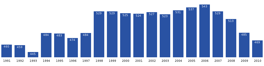
The population of Ittoqqortoormiit has fluctuated over the past two decades, decreasing almost 17% since 2006.[5]
References
| Wikimedia Commons has media related to Ittoqqortoormiit. |
- 1 2 Greenland in Figures 2013 (PDF). Statistics Greenland. ISBN 978-87-986787-7-9. ISSN 1602-5709. Retrieved 6 September 2013.
- ↑ Greenland and the Arctic. By Etain O'Carroll and Mark Elliott. Lonely Planet 2005. ISBN 1-74059-095-3.
- ↑ "Aalborg Twin Towns". Europeprize.net. Retrieved 19 August 2013.
- ↑ "Climate Data and Activities". World Climate guide. Retrieved 15 October 2013.
- 1 2 Statistics Greenland, Population in localities