Itō, Shizuoka
| Itō 伊東市 | |||
|---|---|---|---|
| City | |||
|
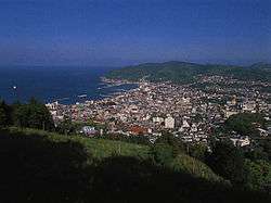
Aerial View of Itō | |||
| |||
 Location of Itō in Shizuoka Prefecture | |||
 Itō
| |||
| Coordinates: 34°57′56.6″N 139°06′6.7″E / 34.965722°N 139.101861°ECoordinates: 34°57′56.6″N 139°06′6.7″E / 34.965722°N 139.101861°E | |||
| Country | Japan | ||
| Region | Chūbu (Tōkai) | ||
| Prefecture | Shizuoka Prefecture | ||
| Area | |||
| • Total | 124.10 km2 (47.92 sq mi) | ||
| Population (September 2015) | |||
| • Total | 68,541 | ||
| • Density | 552/km2 (1,430/sq mi) | ||
| Time zone | Japan Standard Time (UTC+9) | ||
| - Tree | Camellia | ||
| - Flower | Camellia | ||
| - Bird | Blue Rock-thrush | ||
| Phone number | 0557-36-0111 | ||
| Address | 2-1-1 Ōhara, Ito-shi, Shizuoka-ken 414-8555 | ||
| Website |
www | ||


Itō (伊東市 Itō-shi) is a city located on the eastern shore of the Izu Peninsula in Shizuoka Prefecture, Japan.
As of September 2015, the city had an estimated population of 68,541 and a population density of 552 persons per km². The total area was 124.13 square kilometres (47.93 sq mi). Much of the city is part of the Fuji-Hakone-Izu National Park.
Geography

Itō is located in eastern Shizuoka Prefecture, on the northeast corner of Izu Peninsula, facing Sagami Bay on the Pacific Ocean. The landscape is hilly, and Its heavily indented coastline is a scenic area. The climate of Itō is temperate maritime, with hot humid summers, and short, cool winters.
Surrounding municipalities
Shizuoka Prefecture
History
During the Edo period, all of Izu Province was tenryō territory under direct control of the Tokugawa shogunate, and the area now comprising Itō was occupied by 15 small farming and fishing hamlets. It was in this area that the Tokugawa Shogunate ordered Englishman William Adams to construct Japan's first western-style sailing vessels in 1604. The first ship, an 80-ton vessel, was used for surveying work, and the second ship, the 120-ton San Buena Ventura was sailed to Mexico. The period is commemorated in Itō by a street named after Adams (Anjinmiuradori). The area was reorganized into four villages (Tsushima, Itō, Komuro and Usami) within Kamo District the cadastral reform of the early Meiji period in 1889, and were transferred to Tagata District in 1896. On January 1, 1906 the village of Itō was elevated to town status. It annexed neighboring Komuro Village on August 10, 1947 and became the city of Itō. In 1950 Itō was proclaimed an "International Tourism and Cultural City" by the central government. It further expanded through annexation of neighboring Tsushima and Usami villages on April 1, 1955.
Economy
Itō is one of the well known hot spring resort towns near the greater Tokyo metropolis, and tourism is the mainstay of the economy. Commercial fishing and the production of stockfish form a secondary economy.
Education
Itō has ten elementary schools, five middle schools and two high schools. In addition, there are two special education schools.
Transportation
Railway
- East Japan Railway Company - Itō Line
- Izukyu Corporation - Izu Kyūkō Line
- Itō - Minami-Itō - Kawana - Futo - Jōgasaki-Kaigan - Izu-Kōgen
Highways
Sister city relations
 - Suwa, Nagano prefecture, Japan, from May 20, 1965
 - Medway, United Kingdom,[1] from August 10, 1982
 - Rieti, Italy,[1] from July 21, 1985
 - Ismayilli, Azerbaijan, from 2013
Local attractions
- Itō Onsen
- Usami Onsen
- Akazawa Onsen
- Jōgasaki Coast
- Mount Ōmuro
Noted people from Itō
- Mokutaro Kinoshita - author
Itō in media
Itō is featured extensively in the manga Amanchu! by Kozue Amano.
Itō is where takes place the aquatic battle between unit Eva-02 and one enemy angel in the anime Neon Genesis Evangelion, under the sea level in the story.
References
- 1 2 "International Exchange". List of Affiliation Partners within Prefectures. Council of Local Authorities for International Relations (CLAIR). Retrieved 21 November 2015.
External links
![]() Media related to Itō, Shizuoka at Wikimedia Commons
Media related to Itō, Shizuoka at Wikimedia Commons
- Official website (Japanese)
- Itō City official website (English)
| Wards of Shizuoka | ||
|---|---|---|
| Wards of Hamamatsu | ||
| Special cities | ||
| Other cities | ||
| Kamo District | ||
| Tagata District | ||
| Suntō District | ||
| Haibara District | ||
| Shūchi District | ||