Issogne
| Issogne | |
|---|---|
| Comune | |
| Comune di Issogne Commune d'Issogne | |
|
Issogne-Stemma.png | |
 Issogne Location of Issogne in Italy | |
| Coordinates: 45°39′N 7°41′E / 45.650°N 7.683°ECoordinates: 45°39′N 7°41′E / 45.650°N 7.683°E | |
| Country | Italy |
| Region | Valle d'Aosta |
| Province / Metropolitan city | none |
| Frazioni | Barmet, Clapeyas, Favà, Fleuran, Follias, La Colombière, La Place, La Ronchaille Dessous, La Ronchaille Dessus, Les Garines, Les Genot, Les Magaret, Les Mariette, Les Migot, Les Perruchon, Mure, Pied-de-ville, Sommet-de-ville |
| Area | |
| • Total | 23.61 km2 (9.12 sq mi) |
| Elevation | 387 m (1,270 ft) |
| Population (31 December 2014)[1] | |
| • Total | 1,422 |
| • Density | 60/km2 (160/sq mi) |
| Demonym(s) | Issognesi (Italian), Issogneins (French), Issoueigne (Valdôtain dialect), Issinji (Walser German) |
| Time zone | CET (UTC+1) |
| • Summer (DST) | CEST (UTC+2) |
| Postal code | 11020 |
| Dialing code | 0125 |
| Patron saint | Assumption of Mary |
| Saint day | 15 August |
| Website | Official website |
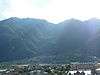
Issogne (Valdôtain dialect: Issoueugne; Töitschu: Issinji) is a town and comune in the Aosta Valley region of north-western Italy. It has 1422 residents and it is known for its a castle and wineries. About a 70% of the local wines are produced from the red Nebbiolo grape, which is native to the neighbouring Piedmont region.
References
This article is issued from Wikipedia - version of the 9/22/2016. The text is available under the Creative Commons Attribution/Share Alike but additional terms may apply for the media files.