Hispaniola
| La Española (Spanish) | |
|---|---|
 View from Hispaniola | |
.svg.png) | |
| Geography | |
| Location | Caribbean |
| Coordinates | 19°N 71°W / 19°N 71°WCoordinates: 19°N 71°W / 19°N 71°W |
| Archipelago | Greater Antilles |
| Area | 76,192 km2 (29,418 sq mi) |
| Area rank | 22nd |
| Coastline | 3,059 km (1,900.8 mi) |
| Highest elevation | 3,175 m (10,417 ft)[1] |
| Highest point | Pico Duarte |
| Administration | |
| Largest settlement | Santo Domingo |
| Largest settlement | Port-au-Prince |
| Demographics | |
| Population | 21,396,000[2] (2014) |
| Pop. density | 280 /km2 (730 /sq mi) |
Hispaniola (Spanish: La Española; Latin: Hispaniola; Taíno: Haiti)[3][4] is the 22nd-largest island in the world, located in the Caribbean island group, the Greater Antilles. It is the second largest island in the Caribbean after Cuba, and the tenth most populous island in the world.
Two sovereign nations share the 76,192-square-kilometre (29,418 sq mi) island. The Dominican Republic, at 48,445 km2 (18,705 sq mi), is nearly twice as large as its neighbour, Haiti, which comprises 27,750 km2 (10,710 sq mi). The only other shared island in the Caribbean is Saint Martin, which is shared between France (Saint-Martin) and the Netherlands (Sint Maarten).
Hispaniola is the site of the first permanent European settlement in the Americas founded by Christopher Columbus on his voyages in 1492 and 1493.[5][6]
History

Etymology
The island was called by various names by its native people, the Taíno Amerindians. No known Taíno texts survive, hence historical evidence for those names comes to us through three Spanish historians: Pietro Martyr d‘Anghiera, Bartolomé de las Casas, and Gonzalo Fernández de Oviedo. Fernández de Oviedo and de las Casas both recorded that the island was called Haiti ("Mountainous Land") by the Taíno. D'Anghiera added another name, Quizqueia (supposedly "Mother of all Lands"), but later research shows that the word does not seem to derive from the original Arawak Taíno language.[3] (Quisqueya is today mostly used in the Dominican Republic.) Although the Taínos use of Haiti is verified and the name was used by all three historians, evidence suggests that it probably was not the Taíno name of the whole island, but only for a region (now known as Los Haitises) in the northeastern section of the present-day Dominican Republic.
When Columbus took possession of the island in 1492, he named it Insula Hispana, meaning "the Spanish Island" in Latin[7] and La Isla Española, meaning "the Spanish Island", in Spanish.[8] De las Casas shortened the name to "Española", and when d‘Anghiera detailed his account of the island in Latin, he rendered its name as Hispaniola.[8] In the oldest documented map of the island, created by Andrés de Morales, Los Haitises is labeled Montes de Haití ("Haiti Mountains"), and de las Casas apparently named the whole island Haiti on the basis of that particular region,[4] since d'Anghiera states that the name of one part was given to the whole island.[3]
Due to Taíno, Spanish and French influences on the island, historically the whole island was often referred to as Haiti, Hayti, Santo Domingo, St. Domingue, or San Domingo. The colonial terms Saint-Domingue and Santo Domingo are sometimes still applied to the whole island, though these names refer, respectively, to the colonies that became Haiti and the Dominican Republic.[9] Since Anghiera's literary work was translated into English and French in a short period of time, the name "Hispaniola" became the most frequently used term in English-speaking countries for the island in scientific and cartographic works. In 1918, the United States occupation government presided by Harry Shepard Knapp obliged the use of the name Hispaniola on the island, and recommended the use of that name to the National Geographic Society.[10] Only recently has the term Hispaniola come into wide use as a name for the geographic unit.
The name Haïti was adopted by Haitian revolutionary Jean-Jacques Dessalines in 1804, as the official name of independent Saint-Domingue, as a tribute to the Amerindian predecessors. It was also adopted as the official name of independent Santo Domingo as the Republic of Spanish Haiti, a state that existed from November 1821 until its forced annexation by Haiti in February 1822.[11][12]
Post-Columbian
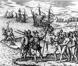
Christopher Columbus inadvertently landed on the island during his first voyage across the Atlantic in 1492, where his flagship, the Santa Maria, sank after running aground on December 25. A contingent of men were left at an outpost christened La Navidad on the north coast of present-day Haiti. On his return the subsequent year, on 22 November 1493 significantly,[13] following the destruction of La Navidad by the local population, Columbus quickly established a second compound farther east in present-day Dominican Republic, La Isabela.
The island was inhabited by the Taíno, one of the indigenous Arawak peoples. The Taino were at first tolerant of Columbus and his crew, and helped him to construct La Navidad on what is now Môle-Saint-Nicolas, Haiti, in December 1492. European colonization of the island began in earnest the following year, when 1,300 men arrived from Spain under the watch of Bartolomeo Columbus. In 1496 the town of Nueva Isabela was founded. After being destroyed by a hurricane, it was rebuilt on the opposite side of the Ozama River and called Santo Domingo. It is the oldest permanent European settlement in the Americas.

The Taíno population of the island rapidly died, 90% from new infectious diseases, to which they had no immunity.[14] Harsh enslavement by Spanish colonists resulted in the death of most of the remainder.[15] In 1503 the colony began to import African slaves, believing them more capable of performing physical labor. The natives had no immunity to European diseases, including smallpox,[16] and entire tribes were destroyed.[17] From an estimated initial population of 250,000 in 1492, 14,000 Arawaks survived in 1517.[18]
In 1574, a census taken of the Greater Antilles reported 1,000 Spaniards and 12,000 African slaves on Hispaniola.[19]
As Spain conquered new regions on the mainland of the Americas, its interest in Hispaniola waned, and the colony’s population grew slowly. By the early 17th century, the island and its smaller neighbors (notably Tortuga) became regular stopping points for Caribbean pirates. In 1606, the government of Philip III ordered all inhabitants of Hispaniola to move close to Santo Domingo, to avoid interaction with pirates. Rather than secure the island, his action meant that French, English and Dutch pirates established their own bases on the abandoned north and west coasts of the island.

In 1665, French colonization of the island was officially recognized by King Louis XIV. The French colony was given the name Saint-Domingue. In the 1697 Treaty of Ryswick, Spain formally ceded the western third of the island to France.[20][21] Saint-Domingue quickly came to overshadow the east in both wealth and population. Nicknamed the "Pearl of the Antilles," it became the richest and most prosperous colony in the West Indies, with a system of human enslavement used to grow and harvest sugar cane, during a time when demand for sugar was high in Europe. Slavery kept prices low and profit was maximized at the expense of human lives. It was an important port in the Americas for goods and products flowing to and from France and Europe.
With the treaty of Peace of Basel, revolutionary France emerged as a major European power. In the second 1795 Treaty of Basel (July 22), Spain ceded the eastern two-thirds of the island of Hispaniola, later to become the Dominican Republic. French settlers had begun to colonize some areas in the Spanish side of the territory.
European colonists often died young due to tropical fevers, as well as from slave resistance in the late eighteenth century. When the French Revolution abolished slavery in the colonies on February 4, 1794, it was a European first,[22] and when Napoleon reimposed slavery in 1802 it led to a major upheaval by the emancipated black slaves.
Thousands of the French Troops sent by Napoleon to reestablished slavery succumbed to a yellow fever during the summer months and more than half of the French army died because of disease.[23] After the French removed the surviving 7,000 troops in late 1803, the leaders of the revolution declared western Hispaniola the new nation of independent Haiti in early 1804. France continued to rule Spanish Santo Domingo. In 1805, Haitian troops of general Henri Christophe tried to conquer all of Hispaniola they invaded Santo Domingo and sacked the towns of Santiago de los Caballeros and Moca, killing most of their residents, but news of a French fleet sailing towards Haiti forced general Christophe to return to the Haiti. Leaving the Eastern Spanish side of the island in French hands. In 1808, following Napoleon's invasion of Spain, the criollos of Santo Domingo revolted against French rule and, with the aid of the United Kingdom (Spain's ally) returned Santo Domingo to Spanish control.
Fearing the influence of a society that had successfully fought and won against their enslavers, the United States and European powers refused to recognize Haiti, the second republic in the western hemisphere. France demanded a high payment for compensation to slaveholders who lost their property, and Haiti was saddled with unmanageable debt for decades.[24] It became one of the poorest countries in the Americas, while the Dominican Republic [24] gradually has developed into the largest economy of Central America and the Caribbean.
Geography
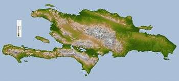
Hispaniola is the second-largest island in the Caribbean (after Cuba), with an area of 76,192 square kilometers (29,418 sq mi), 48,440 square kilometers (18,700 sq mi)[25] of which is under the sovereignty of the Dominican Republic occupying the eastern portion and 27,750 square kilometers (10,710 sq mi)[6] under the sovereignty of Haiti occupying the western portion.
The island of Cuba lies 80 kilometers (50 mi) to the northwest across the Windward Passage; to the southwest lies Jamaica, separated by the Jamaica Channel. Puerto Rico lies east of Hispaniola across the Mona Passage. The Bahamas and Turks and Caicos Islands lie to the north. Its westernmost point is known as Cap Carcasse.
Cuba, Hispaniola, Jamaica, and Puerto Rico are collectively known as the Greater Antilles. The Greater Antilles are made up of continental rock.
The island has five major mountain ranges: The Central Range, known in the Dominican Republic as the Cordillera Central, spans the central part of the island, extending from the south coast of the Dominican Republic into northwestern Haiti, where it is known as the Massif du Nord. This mountain range boasts the highest peak in the Antilles, Pico Duarte at 3,087 meters (10,128 ft) above sea level. The Cordillera Septentrional runs parallel to the Central Range across the northern end of the Dominican Republic, extending into the Atlantic Ocean as the Samaná Peninsula. The Cordillera Central and Cordillera Septentrional are separated by the lowlands of the Cibao Valley and the Atlantic coastal plains, which extend westward into Haiti as the Plaine du Nord (Northern Plain). The lowest of the ranges is the Cordillera Oriental, in the eastern part of the country.
The Sierra de Neiba rises in the southwest of the Dominican Republic, and continues northwest into Haiti, parallel to the Cordillera Central, as the Montagnes Noires, Chaîne des Matheux and the Montagnes du Trou d'Eau. The Plateau Central lies between the Massif du Nord and the Montagnes Noires, and the Plaine de l‘Artibonite lies between the Montagnes Noires and the Chaîne des Matheux, opening westward toward the Gulf of Gonâve, the largest gulf of the Antilles.
The southern range begins in the southwestern most Dominican Republic as the Sierra de Bahoruco, and extends west into Haiti as the Massif de la Selle and the Massif de la Hotte, which form the mountainous spine of Haiti’s southern peninsula. Pic de la Selle is the highest peak in the southern range, the third highest peak in the Antilles and consequently the highest point in Haiti, at 2,680 meters (8,790 ft) above sea level. A depression runs parallel to the southern range, between the southern range and the Chaîne des Matheux-Sierra de Neiba. It is known as the Plaine du Cul-de-Sac in Haiti, and Haiti’s capital Port-au-Prince lies at its western end. The depression is home to a chain of salt lakes, including Lake Azuei in Haiti and Lake Enriquillo in the Dominican Republic.
The island has four distinct ecoregions. The Hispaniolan moist forests ecoregion covers approximately 50% of the island, especially the northern and eastern portions, predominantly in the lowlands but extending up to 2,100 meters (6,900 ft) elevation. The Hispaniolan dry forests ecoregion occupies approximately 20% of the island, lying in the rain shadow of the mountains in the southern and western portion of the island and in the Cibao valley in the center-north of the island. The Hispaniolan pine forests occupy the mountainous 15% of the island, above 850 metres (2,790 ft) elevation. The flooded grasslands and savannas ecoregion in the south central region of the island surrounds a chain of lakes and lagoons in which the most notable include that of Lake Azuei and Trou Caïman in Haiti and the nearby Lake Enriquillo in the Dominican Republic.
Fauna
There are many bird species in Hispaniola, and the island's amphibian species are also diverse.
Flora
The island has four distinct ecoregions. The Hispaniolan moist forests ecoregion covers approximately 50% of the island, especially the northern and eastern portions, predominantly in the lowlands but extending up to 2,100 meters (6,900 ft) elevation. The Hispaniolan dry forests ecoregion occupies approximately 20% of the island, lying in the rain shadow of the mountains in the southern and western portion of the island and in the Cibao valley in the center-north of the island. The Hispaniolan pine forests occupy the mountainous 15% of the island, above 850 metres (2,790 ft) elevation. The flooded grasslands and savannas ecoregion in the south central region of the island surrounds a chain of lakes and lagoons in which the most notable include that of Lake Azuei and Trou Caïman in Haiti and the nearby Lake Enriquillo in the Dominican Republic.
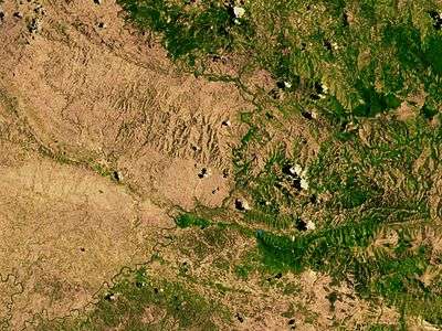
In Haiti, deforestation has long been cited by scientists as a source of ecological crisis; the timber industry dates back to French colonial rule.
Haiti has seen a dramatic reduction of forests due to the excessive and increasing use of charcoal as fuel for cooking. Recent in-depth studies of satellite imagery and environmental analysis regarding forest classification conclude an accurate estimate of approximately 30% tree cover,[26] a stark decrease in the 60% forest cover in 1925. Despite recent in-depth studies, the notoriously unsubstantiated 2% forest cover estimate has been widely circulated in media and in discourse concerning the country.[27] Despite the drastic underestimation of Haiti's forest cover, the country has been significantly deforested over the last 50 years, resulting in the desertification of portions of the Haitian territory.
In the Dominican Republic the forest cover has increased. In 2003 the Dominican forest cover had been reduced to 32% of the territory, but in 2011 the trend towards reducing reverts to increase forest cover by eight percentage points to stand at nearly 40% of territory. The success of the Dominican forest growth is due to several Dominican government policies and private organizations for the purpose, and a strong educational campaign that has resulted in increased awareness on the Dominican people of the importance of forests for their welfare and in other forms of life on the island.[28]
Climate

Owing to its mountainous topography, Hispaniola’s climate shows considerable variation over short distance, and is the most varied of all the Antilles.[29]
Except in the Northern Hemisphere summer season, the predominant winds over Hispaniola are the northeast trade winds. As in Jamaica and Cuba, these winds deposit their moisture on the northern mountains and create a distinct rain shadow on the southern coast, where some areas receive as little as 400 millimetres (16 in) of rainfall and have semi-arid climates. Annual rainfalls under 600 millimetres (24 in) also occur on the southern coast of Haiti’s northwest peninsula and in the central Azúa region of the Plaine du Cul-de-Sac. In these regions, moreover, there is generally little rainfall outside hurricane season from August to October and droughts are by no means uncommon when hurricanes do not come.[30]
On the northern coast, in contrast, rainfall may peak between December and February, though some rain falls in all months of the year. Annual amounts typically range from 1,700 to 2,000 millimetres (67 to 79 in) on the northern coastal lowlands;[29] there is probably much more in the Cordillera Septentrional, though no data exist.
The interior of Hispaniola, along with the southeastern coast centred around Santo Domingo, typically receive around 1,400 millimetres (55 in) per year with a distinct wet season from May to October. Usually this wet season has two peaks: one around May, the other around the hurricane season. In the interior highlands rainfall is much greater, around 3,100 millimetres (120 in) per year, but with a similar pattern to that observed in the central lowlands.
As is usual for tropical islands, variations of temperature are much less marked than with rainfall and depend only on altitude. Lowland Hispaniola is generally oppressively hot and humid, with temperatures averaging 28 °C (82 °F) with high humidity during the daytime and around 20 °C (68 °F) at night. At higher altitudes, temperatures fall steadily, so that frosts occur during the dry season on the highest peaks, where maxima are no higher than 18 °C (64 °F).
Demographics
The island is divided into two sovereign states: the Dominican Republic, which occupies most of the island and is the heir to the Spanish province of Santo Domingo; and the Republic of Haiti which occupies the western third of the island.
The Dominican Republic is a Hispanophone nation of approximately 10 million people. Spanish is spoken by all Dominicans as a primary language. Roman Catholicism is the official and dominant religion.
Haiti is a Francophone nation of roughly 10 million people. Although French is spoken as a primary language by the educated and wealthy minority, virtually the entire population speaks Haitian Creole, one of several French-derived creole languages. Roman Catholicism is the dominant religion, practiced by more than half the population, although in some cases in combination with Haitian Vodou faith. Another 25% of the populace belong to Protestant churches.[31] Haiti emerged as the first Black republic[32] in the world, and is the poorest in Latin America.
Ethnic composition
The ethnic composition of the Dominican population is 73% mixed (African/European), 16% white and 11% black.
The ethnic composition of Haiti is estimated to be 95% black, 5% white and mixed.
Economics
The island has the largest economy in the Greater Antilles, however most of the economic development is found in the Dominican Republic, the Dominican economy being nearly 800% larger than the Haitian economy.
The estimated annual per capita income is US$1,300 in Haiti and US$8,200 in Dominican Republic.[33]
The divergence between the level of economic development between Haiti and Dominican Republic makes its border the higher contrast of all western land borders and is evident that the Dominican Republic has one of the highest migration issues in the Americas.[34]
See also
- Dominican Republic–Haiti relations
- Geography of the Dominican Republic
- Geography of Haiti
- List of divided islands
References
- ↑ Highest Elevation, CIA World Factbook
- ↑ Haiti & The Dominican Republic IMF population estimates.
- 1 2 3 Anglería, Pedro Mártir de (1949). Décadas del Nuevo Mundo, Tercera Década, Libro VII (in Spanish). Buenos Aires: Editorial Bajel.
- 1 2 Las Casas, Fray Bartolomé de (1966). Apologética Histórica Sumaria (in Spanish). Mexico: UNAM.
- ↑ "Embassy of the Dominican Republic, in the United States". Retrieved February 27, 2009.
- 1 2 Central America and Caribbean: Haiti, CIA World Factbook
- ↑ "Quam protinus Hispanam dixi": EPISTOLA DE INSULIS NUPER REPERTIS (Letter to Lord Raphael Sanchez, March 14, 1493).
- 1 2 McIntosh, Gregory C (2000). The Piri Reis Map of 1513. University of Georgia Press. p. 88. ISBN 978-0-8203-2157-8.
- ↑ Schwartz, Albert (1989). "The Butterflies of Hispaniola". p. 10. ISBN 978-0-8130-0902-5. Retrieved 12 April 2015.
- ↑ Castillo Pantaleón, Juan Miguel (2012). La Nacionalidad Dominicana (in Spanish). Santo Domingo: Editora Nacional, Ministerio de Cultura. p. 329. ISBN 978-9945-469-97-4. Retrieved 15 June 2015.
- ↑ Lancer, Jalisco. "The Conflict Between Haiti and the Dominican Republic". All Empires Online History Community. Retrieved 2007-12-24.
- ↑ "Haiti - Historical Flags". Flags of the World. Retrieved 2007-12-24.
- ↑ Voyage 2 - Columbus and Dominica Isabella I of Castile
- ↑ Abbot, Elizabeth (1 April 2010). Sugar: A Bittersweet History. Penguin. ISBN 978-1-59020-772-7. Retrieved 5 March 2013.
- ↑ Abbot 2010.
- ↑ "History of Smallpox – Smallpox Through the Ages". Texas Department of State Health Services.
- ↑ Austin Alchon, Suzanne (2003). A pest in the land: new world epidemics in a global perspective. University of New Mexico Press. p. 62. ISBN 0-8263-2871-7.
- ↑ Lord, Lewis (January 21, 2007). "A Conqueror More Lethal Than the Sword". US News and World Report.
- ↑ Morison, Samuel Eliot (1972). The Oxford History of the American People. New York City: Mentor. p. 71. ISBN 0-451-62600-1.
- ↑ "Hispaniola Article". Britannica.com. Retrieved 4 January 2014.
- ↑ "Dominican Republic 2014". Retrieved 24 April 2014.
- ↑ Popkin, Jeremy D. (2008) Facing Racial Revolution: Eyewitness Accounts of the Haitian Insurrection. pp. 184–213. ISBN 0226675831
- ↑ Bollet, A.J. (2004). Plagues and Poxes: The Impact of Human History on Epidemic Disease. Demos Medical Publishing. pp. 48–49. ISBN 1-888799-79-X.
- 1 2 Diamond, Jared M. and Robinson, James A. (2011) Natural Experiments of History. pp. 126–128. ISBN 9780674060197
- ↑ Central America and Caribbean: Dominican Republic, CIA World Factbook
- ↑ EnviroSociety. Tarter, Andrew http://www.envirosociety.org/2016/05/haiti-is-covered-with-trees/. Retrieved 19 May 2016. Missing or empty
|title=(help) - ↑
- ↑ FUNGLODE - República Dominicana aumenta su cobertura boscosa a 39.7%
- 1 2 Alpert, Leo (1941). "The Areal Distribution of Mean Annual Rainfall Over the Island of Hispaniola". Monthly Weather Review. 69 (7): 201. doi:10.1175/1520-0493(1941)069<0201:TADOMA>2.0.CO;2.
- ↑ Camberlin, Pierre (2010). "More variable tropical climates have a slower demographic growth" (PDF). Climate Research. 41: 157. doi:10.3354/cr00856.
- ↑ "The World Factbook". Cia.gov.
- ↑ "Haitians Heroes" (PDF). Palmbeachschools.org.
- ↑ Bello, Marisol (January 21, 2010). "Hispaniola comparison". USA Today. Retrieved 2016-10-09.
- ↑ IMF - PIB per cápita (PPA) República Dominicana / Haití
External links
| Wikivoyage has a travel guide for Hispaniola. |
| Look up hispaniola in Wiktionary, the free dictionary. |
| Wikimedia Commons has media related to Hispaniola. |
- Google maps
- Map of the Islands of Hispaniola and Puerto Rico from 1639
 Champlin, Jr., John D. (1880). "Hayti". Encyclopædia Britannica. 11 (9th ed.).
- The Kraus Collection of Sir Francis Drake at the Library of Congress contains primary materials on Hispaniola.