Irshalgad
Coordinates: 18°56′01″N 73°13′55″E / 18.933568°N 73.232031°E

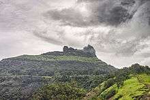
Irshalgad is a fortress located between Matheran and Panvel in Maharashtra, India. It is a sister fort to Prabalgad. The area of the fort is not large but there are several water cisterns cut from the rock. The nearest village is Irshalwadi.[1]
Trekking to Irshalgad
Irshalgad pinnacle is accessible by an easy to moderate 3.4 kilometre / 2 hour trek. The road head, if travelling by your own vehicle is Karja village near Chowk town. Chowk town lies on NH4 that connects Panvel with Karjat. Chowk also has a train station (Station code CHOK) . (Pune - Bhusaval express) stops at Chowk train station. From Chowk, Karja village (the starting point of this trek) is a comfortable 2.3 kilometres walk. From Karja village you follow a wide well defined path till Irshalwadi village. The path climbs a steep ridge and then tapers to an easy ascend till Irshalwadi. From Irshalwadi village head towards a temple dedicated to a local deity and access the Irshalgad plateau via a west-east axis. The trek is child friendly till the pinnacle base.[2]
References
- ↑ "Giridarshan Trekking". Retrieved 2009-09-07.
- ↑ Bharat Singh Bhadwal. "Monsoon day trek to Irshalgad pinnacle - wind and water". www.inditramp.com. Retrieved 15 August 2015.