Republic of Ireland–United Kingdom border
| Ireland–United Kingdom border | |
|---|---|
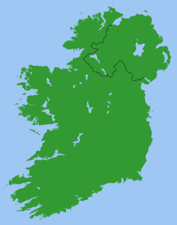 A map showing the Republic of Ireland – United Kingdom border. | |
| Characteristics | |
| Entities |
|
| Length | 499 km (310 mi) |
| History | |
| Established | 3 May 1921 |
| Partition of Ireland | |
| Current shape | 7 December 1922 |
| Northern Ireland opt out of the Free State | |
| Treaties | Anglo-Irish Treaty |
| Notes | Open border not officially marked by either government |
The Republic of Ireland–United Kingdom border is the boundary between the Republic of Ireland and the United Kingdom. It is also referred to as the Irish border or, on either side of it, simply as the border.
The border runs for a total of 499 km (310 mi)[1][2] from Lough Foyle in the north of Ireland to Carlingford Lough in the northeast (on the Irish Sea), separating the Republic from Northern Ireland. The Irish border is considered one of the most atypical of international boundaries, in terms of its historical origins, geographical context, and administrative regime.[2]
Border markings are comparatively inconspicuous, in common with many international borders in the European Union although, unlike many other EU borders, there are no signposts at crossing points notifying travellers that they are entering a different jurisdiction. While both states are outside the European Union's Schengen Area, they do share a Common Travel Area, resulting in an essentially open border since 1923.
Establishment
Originally intended as an internal boundary within the United Kingdom of Great Britain and Ireland, the border was created in 1921 under the United Kingdom Parliament's Government of Ireland Act 1920.[3] Prior to this, a separatist Irish parliament had been established in Dublin, which did not recognise the Government of Ireland Act, and was actively engaged in the Irish War of Independence. The Act was intended to deliver Home Rule in Ireland, with separate parliaments for Southern Ireland and Northern Ireland. Six of the thirty-two counties of Ireland were assigned to Northern Ireland, and the rest of Ireland comprising 26 counties to Southern Ireland.
The success of the Irish War of Independence, and the subsequent signing of the Anglo-Irish Treaty, led to the creation of the Irish Free State - a Dominion established for the whole island of Ireland on 6 December 1922. The border became an international frontier after the Parliament of Northern Ireland exercised its right to opt out of the Free State on 7 December 1922. The partition of 1921 created only a provisional boundary; a Boundary Commission met in 1924–5 to fix a permanent border between the two jurisdictions "in accordance with the wishes of the inhabitants, so far as may be compatible with economic and geographic conditions".[4] The manner in which the Boundary Commission clause was drafted in the Anglo-Irish Treaty was only explicit in its ambiguity.[5] Amongst politicians in Southern Ireland, there was remarkably little attention paid to the clause during the debates on the Treaty. The Republican activist Sean MacEntee was a "lone voice" in warning that the commission would involve an exercise “in transferring from the jurisdiction of the Government of Northern Ireland certain people and certain districts which that Government cannot govern; and by giving instead to Northern Ireland, certain other districts—unionist districts of Monaghan, Cavan and Donegal, so that not only under this Treaty are we going to partition Ireland, not only are we going to partition Ulster, but we are going to partition even the counties of Ulster.”[2][6]
The interim boundary was formalised in December 1925 by an inter-government agreement that was ratified by the three parliaments in London, Dublin and Belfast, without changes from the 1920 demarcation lines.[4][7] The Boundary Commission's report was superseded by events and so it was not published until 1969.[4] The border agreement was then lodged with the League of Nations on 8 February 1926, making it a matter of international law.
The Irish Free State was renamed Ireland (Irish: Éire) by the 1937 constitution, and the Republic of Ireland Act 1948 formally declared that it was a republic with the official description Republic of Ireland while not changing its name, which remains Ireland.
Customs and identity checks

Customs controls were introduced on the frontier on 1 April 1923, shortly after the establishment of the Irish Free State.[8] These controls were maintained, with varying degrees of severity, until 1 January 1993, when systematic customs checks were abolished between European Community member states as part of the single market.[9][10][11] There are no longer any operational customs posts along either side of the border. Except during a brief period in WWII it has never been necessary for Irish or British citizens to produce a passport to cross the border. However during the 1970s troubles, security forces regularly asked travellers for identification.
Military checkpoints
During the Troubles in Northern Ireland, there were British military checkpoints on main border crossings and UK security forces made the remaining crossings impassable. By about 2005, in phase with implementation of the 1998 Good Friday Agreement, these controls were removed.
Dropped proposals to reinstate border controls
In October 2007, details began to emerge of a British Government plan that might end the Common Travel Area encompassing the United Kingdom and Ireland (and also the Isle of Man and Channel Islands) in 2009, possibly creating an anomalous position for Northern Ireland in the process.[12] In a statement to Dáil Éireann, the Irish Taoiseach Bertie Ahern assured the House that "British authorities have no plans whatsoever to introduce any controls on the land border between North and South. I want to make that clear. All they are looking at is increased cross-border cooperation, targeting illegal immigrants."[12] This immediately raised concerns north of the border. Jim Allister, a former member of the Democratic Unionist Party and then a Member of the European Parliament, told The Times that it would be "intolerable and preposterous if citizens of the UK had to present a passport to enter another part of the UK".[12]
In July 2008, the UK and Irish governments announced their intent to resume controls over their common border and the Common Travel Area in general. Each proposed to introduce detailed passport control over travellers from the other state, where travel is by air or sea.[13] However, the land border will be 'lightly controlled'.[14] In a joint statement, Jacqui Smith, the British Home Secretary, and Dermot Ahern, the Irish Justice Minister, said:
It is crucial that our two countries work closely together to ensure our borders are stronger than ever. Both governments fully recognise the particular circumstances of Northern Ireland. Both governments reaffirm that they have no plans to introduce fixed controls on either side of the Irish land border.[13]
The Times reported that another consultation paper was to be published in the autumn of 2008 on whether people travelling between Northern Ireland and the rest of the United Kingdom should be subject to further checks.
One proposal is expected to suggest extending the electronic borders scheme, requiring travellers from Northern Ireland to provide their personal details in advance. This would mean residents of one part of the UK being treated differently from others when travelling within the country, something to which Unionists would object.[13]
However, in 2011, the Governments renewed the 'de facto' agreement.
The 2011 inter-government agreement
2011 marked the first public agreement between the UK and Irish governments concerning the maintenance of the Common Travel Area. Officially entitled the "Joint Statement Regarding Co-Operation on Measures to Secure the External Common Travel Area Border", it was signed in Dublin on 20 December 2011 by the UK's immigration minister, Damian Green and Ireland's Minister for Justice, Alan Shatter.[15]
As EU Border
The UK voted to leave the European Union in a referendum on 23 June 2016. Their withdrawal would make the Republic of Ireland-Northern Ireland border an external EU border.[16] However, as Evan Smith argues, this border has been diffcult to police in the past and it is unclear as to whether border controls would be implemented.[17] In September 2016 the British Secretary of State for Exiting the European Union stated that the UK government would not seek a return to a "hard border" between the UK and Ireland.[18]
The Troubles
The Troubles in Northern Ireland required that attempts were made from the early 1970s until the late 1990s to enforce border controls. Many smaller cross-border roads were cratered or blockaded with the intention of making them impassable to regular traffic. Bridges were also destroyed to prevent access at unauthorised border crossings (known officially as "unapproved roads"). In particular, the border area in south County Armagh was dominated by British Army surveillance posts. Derry, the second-largest city in Northern Ireland, is close to the border with County Donegal. This meant that there was a heavy security presence around the city, often impeding traffic and general movement between Derry City and County Donegal. Despite these measures, the border was simply too long and had too many minor access roads to enable control of all cross-border movements. In any case, authorised crossing-points on the border remained open to civilian traffic in both directions at all times although vehicles and their occupants were subject to detailed searches while some crossing points were closed to vehicle traffic at night when customs posts were unstaffed.
Difficulty in patrolling parts of the border and large taxation/currency differences (particularly during the 1980s) led to widespread smuggling. However, greater European integration has led to roughly similar tax rates on most items and easing of restrictions on cross-border trade. Smuggling nowadays is mostly limited to fuel, livestock and a seasonal trade in illegal fireworks, which are strictly regulated in Ireland - in both countries there are restrictions on the types which can be used and a licence is required to possess or use fireworks, but in Ireland such licences are seldom issued to private individuals.
While it still exists, the border presents no impediments to traffic in either direction. This has been mainly due to the Common Travel Area between Ireland and the United Kingdom, as well as a sharp reduction in cross-border activity by paramilitaries. EU integration has also played a part. Following the Northern Ireland peace process, military surveillance has been replaced by routine PSNI patrols.
Distinctive physical characteristics

The border is extremely irregular. Its irregularities were inherited from well-established county boundaries.[5] The 499 km (310 mi)[1] border is not explicitly described in statute but only implicitly inferred from the territorial definition of Northern Ireland as contained in the 1920 Government of Ireland Act. It states that “Northern Ireland shall consist of the parliamentary counties of Antrim, Armagh, Down, Fermanagh, Londonderry and Tyrone, and the parliamentary boroughs of Belfast and Londonderry, and Southern Ireland shall consist of so much of Ireland as is not comprised within the said parliamentary counties and boroughs."[19] The border has some distinctive features. Firstly, how irregular it is: the border is about four times the straight-line distance between Lough Foyle and Carlingford Lough.[5] Second, County Donegal is only connected to the rest of Ireland by a territorial isthmus 9 km (6 mi) wide, making it more convenient for some journeys from Donegal to other parts of Ireland to pass through Northern Ireland. Third, for only two relatively short sections of the border does it align with the provincial boundary of nine county Ulster between Fermanagh-Leitrim and Armagh-Louth. And lastly, as the border skirts Tyrone to the west and again to the south east, it encompasses Co. Fermanagh on three sides.
As a remnant of 17th century county limits, the border’s physical profile indicates that it follows many water courses but only in the highlands of the Cavan-Fermanagh section could the border be said to accord with any significant physical impediments to movement.[5]
Maritime border
A 1988 treaty demarcates the boundary of the exclusive economic zones across the continental shelf from the south Irish Sea southwest to the Celtic Sea.[20]
Waters around Northern Ireland
The exact division of territorial waters between Northern Ireland and Southern Ireland ('Southern Ireland' being coterminous with the territory of the modern-day Irish state) was a matter of some controversy from the outset. Section 1(2) of the Government of Ireland Act 1920 defined the respective territories of Northern Ireland and the then Southern Ireland as follows:[21]
...Northern Ireland shall consist of the parliamentary counties of Antrim, Armagh, Down, Fermanagh, Londonderry and Tyrone, and the parliamentary boroughs of Belfast and Londonderry, and Southern Ireland shall consist of so much of Ireland as is not comprised within the said parliamentary counties and boroughs.
At the time of that Act, both Northern Ireland and Southern Ireland were to remain parts of the United Kingdom. Perhaps because of this, the Act did not explicitly address the position of territorial waters although Section 11(4) provided that neither Southern Ireland nor Northern Ireland would have any competence to make laws in respect of "Lighthouses, buoys, or beacons (except so far as they can consistently with any general Act of the Parliament of the United Kingdom be constructed or maintained by a local harbour authority)”.
When the territory that initially was Southern Ireland ultimately became a separate self-governing dominion outside the United Kingdom known as the Irish Free State, the status of the territorial waters naturally took on a significance it had not had before. Northern Ireland's Unionists were conscious of this matter from an early stage. They were keen to put it beyond doubt that the territorial waters around Northern Ireland would not belong to the Irish Free State. In this regard, James Craig, the Prime Minister of Northern Ireland put the following question in the British House of Commons on 27 November 1922 (the month before the establishment of the Irish Free State):[22]
Another important matter on which I should like a statement of the Government's intentions, is with regard to the territorial waters surrounding Ulster. Under the Act of 1920, the areas handed over to the Governments of Northern Ireland and Southern Ireland respectively, were defined as the six Parliamentary counties of Northern Ireland and the twenty-six Parliamentary counties of Southern Ireland. I understand there is considerable doubt in the minds of lawyers and others as to whether these Parliamentary counties carry with them the ordinary territorial waters, extending three miles out from the shore. It has been asserted in some quarters that the Parliamentary counties only extend to low water mark. That has been exercising the minds of a good many people in Ulster, and I shall be glad if the Government in due course will inform the House what is their opinion on the subject and what steps they are taking to make it clear..... Am I to understand that the Law Officers have actually considered this question, and that they have given a decision in favour of the theory that the territorial waters go with the counties that were included in the six counties of Northern Ireland?
In response the Attorney General, Sir Douglas Hogg, said that "I have considered the question, and I have given an opinion that that is so [i.e. the territorial waters do go with the counties]".
However, this interpretation that the territorial waters went with the counties was later disputed by Irish Governments. A good summary of the Irish position was given by the then Taoiseach, Jack Lynch, during a Dáil debate on 29 February 1972:
...[W]e claim that the territorial waters around the whole island of Ireland are ours and our claim to the territorial waters around Northern Ireland is based on the Government of Ireland Act of 1920. This Act is so referred to in the 1921 Treaty that the Northern Ireland which withdrew from the Irish Free State is identical with the Northern Ireland defined in the Government of Ireland Act, 1920, and defined as consisting of named counties and boroughs. It is, I think, common case between us that in English law the counties do not include adjacent territorial waters and, therefore, according to our claim these territorial waters were retained by the Irish Free State.
A particular dispute arose between the Government of the Irish Free State of the one part and the Northern Ireland and UK governments of the other part over territorial waters in Lough Foyle.[23] Lough Foyle lies between County Londonderry in Northern Ireland and County Donegal in the then Irish Free State. A court case in the Free State in 1923 relating to fishing rights in Lough Foyle held that the Free State's territorial waters ran right up to the shore of County Londonderry.[23] In 1927, illegal fishing on Lough Foyle had become so grave that Northern Ireland Prime Minister James Craig entered into correspondence with his Free State counterpart, W. T. Cosgrave. Craig indicated to Cosgrave that he proposed to introduce a Bill giving the Royal Ulster Constabulary powers to stop and search vessels on Lough Foyle. Cosgrave asserted all of Lough Foyle was Free State territory and that as such a Bill of that nature would be rejected by the Free State and its introduction would create "a very serious situation".[23] Cosgrave then raised the matter with the British government.
It appears that the territorial waters generally are no longer disputed between the two states but the maritime boundary dispute between Ireland and the United Kingdom concerning Lough Foyle (and similarly Carlingford Lough) may still not have been settled. As recently as 2005, when asked to list those areas of EU member states where border definition is in dispute, a British Government minister responding for the Secretary of State for Foreign and Commonwealth Affairs stated: "Border definition (ie the demarcation of borders between two internationally recognised sovereign states with an adjoining territorial or maritime border) is politically disputed [between] Ireland [and the] UK (Lough Foyle, Carlingford Lough—quiescent)"[24] It appears moves have been made on the Irish side to settle the issue. During Dáil debates on the Carlingford Fisheries Bill, a contributor to the debate stated that he welcomed "the Bill's aim of defining the area of jurisdiction over the Foyle."[25] However, it appears that the Carlingford Fisheries Act 2007 ultimately remained silent on the point.
Identification

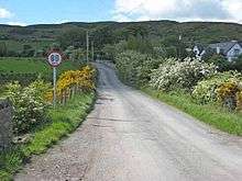
Unlike other borders in the EU, the Irish border is not officially marked by either government. This can make identifying the border difficult for those unfamiliar with landmarks known to locals as the crossing point. At some crossings, there are signs welcoming visitors to the relevant local government authority district or, occasionally, reminding motorists of the need to ensure that their insurance is valid in the relevant jurisdiction. In 2012 a number of "Welcome To Northern Ireland" road signs were placed along the border by the Northern Ireland Roads Service.[26]
Generally, signposts in Ireland which indicate distances to destinations are bilingual (in Irish and English) and give distances in kilometres while such signposts in Northern Ireland are only in English and give distances in miles. On larger roads, the approximate location of the border can be determined by signs reminding the driver of the change in units. In Northern Ireland, place-name and street/road-name signs are usually (but not always) English-only and street/road-name signs are more standardised and extensively used.
There are other immediate indicators when crossing the border: differences in the design of road signage and a change in road markings. The hard shoulder on non-motorway roads in Ireland is marked with a yellow, usually broken, line. The same marking in Northern Ireland is white and usually continuous. In Northern Ireland, roads use A (major) and B (minor) route prefixes, whereas Ireland's route prefixes are N (major, standing for national) and R (minor, standing for regional). Road signs in Ireland are mostly black/yellow and diamond shaped (similar to those in North America and Australasia) whereas those in the UK are mainly black/white/red triangles or circles (the same as the rest of the European Union). Signs also have subtle differences in colouring and fonts.
Since the adoption by Ireland of metric speed limits, warning signs have been placed on either side of the border to alert motorists to the change to or from miles or kilometres per hour. As the United Kingdom does not use the euro, advertised prices for service stations and shops will change currency on crossing, although many places along the border will accept cross-border currency informally (albeit usually at a rate favourable to the trader). Other typical signs of crossing a European border are also noticeable. These include subtle differences in the paving materials of road surfaces and pavements, sometimes with visible differences in colour between materials across the border, changes to street lighting when crossing the border, (though these also vary across intra-county borders), and changes in the colour of postboxes (green in Ireland, red in Northern Ireland).
By rail, there is no immediate sign of crossing the border, but the trackside mileage markers change from Irish-style markers at the 59¾-mile post (from Dublin Connolly railway station) to black-on-yellow markers, common to the United Kingdom, at the 60-mile (97 km) post, between Dundalk and Newry stations.
Mobile phone roaming charges
As in most places, radio signals from the cellular networks on both of the border sides often travel several kilometres (a few miles) across it. This is a source of annoyance to those resident in border areas as roaming charges are incurred with most service providers if the phone connects to the "wrong" network when making or even receiving a call.[27][28] It is believed that one third of mobile phone users in Northern Ireland have been affected by this.[29] Discussion between the relevant communication regulators in the two jurisdictions is under way in an attempt to resolve the issue. Irish operator Meteor has abolished charges for their customers receiving calls in Northern Ireland, if roaming on Northern Ireland's T-Mobile network. Meteor has created a special Northern Ireland roaming tariff for both contact and prepay customers. O2 Ireland introduced and then abandoned an initial "all Ireland tariff". However they still have one available on request, to billpay customers and businesses in Ireland, and another trial all-Ireland plan for businesses in Northern Ireland.[30] UK mobile networks have not provided such tariffs to their Northern Ireland customers. 3 Ireland also has a 3 Like Home tariff which allows Irish mobile phone users to use their phones in the UK at no extra cost, similarly 3 UK have introduced "Feel at Home" which offers the same in reverse.
Cultural references
Puckoon is a comic novel by Spike Milligan, first published in 1963. It is set in 1924 and details the troubles brought to the fictional Irish village of Puckoon by the Partition of Ireland when the new border, passes directly through the village.
Border settlements
The following cities, towns and villages are located on the border or not far from it (listed from Lough Foyle to Carlingford Lough):
- Muff, Inishowen, County Donegal
- Culmore, County Londonderry
- Derry, County Londonderry
- Bridgend, County Donegal
- Killea, County Donegal
- Newtowncunningham, County Donegal
- Carrigans, County Donegal
- St. Johnston, County Donegal
- Lifford, County Donegal (linked to Strabane by Lifford Bridge)
- Strabane, County Tyrone (linked to Lifford by Lifford Bridge)
- Clady, County Tyrone
- Castlefin, County Donegal
- Castlederg, County Tyrone
- Killeter, County Tyrone
- Pettigo, County Donegal and Tullyhommon, County Fermanagh (separated by a river)
- Ballyshannon, County Donegal
- Bundoran, County Donegal
- Belleek, County Fermanagh (part of Belleek is actually in County Donegal, as the border passes through the town but most of it is on the 'northern' side)[31]
- Kiltyclogher, County Leitrim
- Blacklion, County Cavan and
- Belcoo, County Fermanagh (linked to Blacklion by bridge)
- Swanlinbar, County Cavan
- Ballyconnell, County Cavan
- Scotshouse, County Monaghan
- Newtownbutler, County Fermanagh
- Clones, County Monaghan
- Aughnacloy, County Tyrone
- Glaslough, County Monaghan
- Caledon, County Tyrone
- Middletown, County Armagh
- Cullaville, County Armagh
- Forkhill, County Armagh
- Dundalk, County Louth
- Jonesborough, County Armagh
- Newry, County Armagh/County Down
- Meigh, County Armagh
- Warrenpoint, County Down
- Omeath, County Louth
See also
Sources
- Denton, Gilbert; Fahy, Tony (1993). "The Northern Ireland Land Boundary 1923–1992". Belfast: HM Customs and Excise. OCLC 56443670.
References
- 1 2 Ordnance Survey of Northern Ireland, 1999
- 1 2 3 MFPP Working Paper No. 2, "The Creation and Consolidation of the Irish Border" by KJ Rankin and published in association with Institute for British-Irish Studies, University College Dublin and Institute for Governance, Queen's University, Belfast (also printed as IBIS working paper no. 48)
- ↑ The island of Ireland was partitioned into two distinct regions of the United Kingdom, by Order in Council on 3 May 1921 (Statutory Rules & Orders published by authority (SR&O) 1921, No. 533).
- 1 2 3 Report of the Irish Boundary Commission, 1925 Introduced by Geoffrey J. Hand (Shannon: Irish University Press, 1969) ISBN 0-7165-0997-0
- 1 2 3 4 MFPP Working Paper No. 2, "The Creation and Consolidation of the Irish Border" by KJ Rankin and published in association with Institute for British-Irish Studies, University College Dublin and Institute for Governance, Queen's University, Belfast (also printed as IBIS working paper no. 48)
- ↑ Official report: debate on the Treaty between Great Britain and Ireland, 1922: 155, (22 December 1921).
- ↑ Treaty (Confirmation of Amending Agreement) Act, 1925 Irish Statute Book
- ↑ Denton and Fahy 1993, pp.19–20
- ↑ Denton and Fahy 1993, p.iii
- ↑ O'Kane, Paul (29 December 1992). "500 Customs workers are redeployed to new tasks". The Irish Times. p. 7.
- ↑ Paymaster-General, Sir John Cope, House of Common Debates volume 208 column 556-7W (3 June 1992): "With the creation of the single market, fiscal frontiers between member states will disappear. As from 1 January 1993, there will be no routine or systematic customs formalities and goods will move freely across internal EC frontiers."
- 1 2 3 Sharrock, D. (25 October 2007). "New border control will abolish free movement between UK and Ireland". The Times. Retrieved 10 June 2008.
- 1 2 3 Britain and Ireland agree to tighten border check
- ↑ Strengtening the common travel area: a consultation paper (PDF) "We are clear that we will not introduce fixed immigration controls on the land border between Northern Ireland and Ireland or on traffic from the Crown dependencies to the UK. However, mirroring activity in Ireland, the UK will consider increasing ad hoc immigration checks on vehicles in order to target non-CTA nationals on the Northern Ireland side of the land border."
- ↑ CO-OPERATION ON MEASURES TO SECURE THE EXTERNAL COMMON TRAVEL AREA BORDER – The Home Office December 2012
- ↑ Smith, Evan (20 July 2016). "Brexit and the history of policing the Irish border". History & Policy. History & Policy. Retrieved 21 July 2016.
- ↑ Smith, Evan (20 July 2016). "Brexit and the history of policing the Irish border". History & Policy. History & Policy. Retrieved 21 July 2016.
- ↑ "Brexit secretary: no return to 'hard' border in Ireland". The Telegraph. London. 1 September 2016. Retrieved 28 September 2016.
- ↑ Government of Ireland Act 1920, Section 1 Clause 2 (10 & 11 Geo. 5 c.67)).
- ↑ Janes, Andrew (7 November 2013). "The boundary line". Records and research. London: The National Archives. Retrieved 8 November 2013.
- ↑ Section 1(2) of the Government of Ireland Act 1920
- ↑ Hansard – Commons Debate on Irish Free State (Consequential Provisions) Bill, 27 November 1922
- 1 2 3 Division and Consensus By Michael Kennedy, Institute of Public Administration (Ireland)
- ↑ Hansard report of House of Commons Debate on 13 January 2008
- ↑ Dáil Éireann – Volume 629 – 14 December 2006
- ↑ "'Welcome to Northern Ireland' signs spark political row". The Journal. 7 August 2012. Retrieved 23 November 2016.
- ↑ "Cross-border telecoms issues", Report of ComReg/Ofcom Joint Working Group, 19 January 2005
- ↑ "Follow O2 roaming move – Dempsey", RTÉ News, Wednesday, 8 February 2006
- ↑ "Mobile users take border roaming hit", RTÉ News, Wednesday, 19 January 2005
- ↑ All-Ireland tariff 'will be good for business' Belfast Telegraph, Tuesday, 19 June 2012.
- ↑ Picture: N3 Northbound sic (with yellow margin lines) becomes the A46 (with white margin lines and speed limit in MPH). At 54:28:38N,8:05:54W
External links
- Centre for Cross Border Studies promotes "Cross-border Cooperation" under the Good Friday Agreement; spinoff websites:
- Border People "the central access point for cross-border mobility information on the island of Ireland", developed for the North/South Ministerial Council
- Border Ireland "online searchable database of cross-border information" (funding ended in 2009)
- Mapping Frontiers 2004–06 joint project of Queen's University Belfast and University College Dublin