Iranshahr (city)
| Iranshahr ايرانشهر | |
|---|---|
| city | |
|
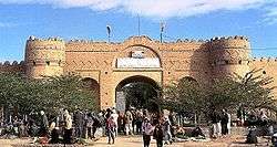
Naseri fortress | |
 Iranshahr | |
| Coordinates: 27°12′09″N 60°41′05″E / 27.20250°N 60.68472°ECoordinates: 27°12′09″N 60°41′05″E / 27.20250°N 60.68472°E | |
| Country |
|
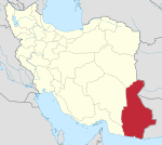
| Province | Sistan and Baluchestan |
| County | Iranshahr |
| Bakhsh | Central |
| Population (2010) | |
| • Total | 100,000 |
| Time zone | IRST (UTC+3:30) |
| • Summer (DST) | IRDT (UTC+4:30) |
Iranshahr (Persian: ايرانشهر, also Romanized as Īrānshahr; formerly, Fahrej, Fehruj, and Qal‘eh-ye Nāşerī)[1] is a city in and capital of Iranshahr County, Sistan and Baluchestan Province, Iran. As of 2010 the population of Iranshahr was 100,000. The city is predominantly inhabited by ethnic Baloch speaking the Balochi language.
Before 1935 the city was called Pahrah (Persian: پهره), also spelt Poora, Poorah, and Pura. The name was changed to Iranshahr by Mohammad Reza Shah Pahlavi in about 1937.
Pahrah is the site where Alexander the Great celebrated and regrouped his troops after his Indian conquests. The city used to be the center of the government of Balochistan and has been invaded and conquered numerous times during the course of its history. Bampur, where the ancient Bampur fort is located, is nearby.
Climate
Iranshahr has a hot desert climate (Köppen climate classification BWh) with extremely hot summers and mild winters. Precipitation is very low, and mostly falls in winter.
| Climate data for Iranshahr | |||||||||||||
|---|---|---|---|---|---|---|---|---|---|---|---|---|---|
| Month | Jan | Feb | Mar | Apr | May | Jun | Jul | Aug | Sep | Oct | Nov | Dec | Year |
| Record high °C (°F) | 30.0 (86) |
33.0 (91.4) |
38.0 (100.4) |
43.0 (109.4) |
48.0 (118.4) |
49.0 (120.2) |
49.0 (120.2) |
50.0 (122) |
47.0 (116.6) |
44.0 (111.2) |
37.0 (98.6) |
33.0 (91.4) |
50 (122) |
| Average high °C (°F) | 21.4 (70.5) |
23.4 (74.1) |
29.2 (84.6) |
35.0 (95) |
41.3 (106.3) |
44.9 (112.8) |
44.6 (112.3) |
43.6 (110.5) |
40.7 (105.3) |
35.8 (96.4) |
29.5 (85.1) |
23.6 (74.5) |
34.42 (93.95) |
| Daily mean °C (°F) | 15.3 (59.5) |
17.7 (63.9) |
22.7 (72.9) |
28.4 (83.1) |
34.8 (94.6) |
38.3 (100.9) |
38.1 (100.6) |
37.1 (98.8) |
33.9 (93) |
28.9 (84) |
22.4 (72.3) |
17.0 (62.6) |
27.88 (82.18) |
| Average low °C (°F) | 7.6 (45.7) |
9.8 (49.6) |
14.0 (57.2) |
19.0 (66.2) |
24.4 (75.9) |
28.7 (83.7) |
29.8 (85.6) |
28.2 (82.8) |
24.1 (75.4) |
18.7 (65.7) |
12.6 (54.7) |
8.6 (47.5) |
18.79 (65.83) |
| Record low °C (°F) | −2 (28) |
−1.0 (30.2) |
4.0 (39.2) |
10.0 (50) |
14.4 (57.9) |
22.0 (71.6) |
22.0 (71.6) |
20.0 (68) |
14.0 (57.2) |
8.0 (46.4) |
2.0 (35.6) |
−6.0 (21.2) |
−6 (21.2) |
| Average precipitation mm (inches) | 24.8 (0.976) |
25.0 (0.984) |
19.2 (0.756) |
5.6 (0.22) |
2.6 (0.102) |
2.6 (0.102) |
14.3 (0.563) |
5.2 (0.205) |
1.5 (0.059) |
0.8 (0.031) |
1.5 (0.059) |
11.6 (0.457) |
114.7 (4.514) |
| Average rainy days | 4.6 | 4.0 | 3.7 | 1.8 | 0.8 | 0.7 | 2.0 | 1.2 | 0.3 | 0.2 | 0.5 | 3.0 | 22.8 |
| Average snowy days | 0.1 | 0 | 0 | 0 | 0 | 0 | 0 | 0 | 0 | 0 | 0 | 0 | 0.1 |
| Average relative humidity (%) | 46 | 43 | 36 | 29 | 22 | 23 | 28 | 27 | 24 | 26 | 31 | 40 | 31.3 |
| Mean monthly sunshine hours | 232.9 | 223.5 | 249.4 | 254.3 | 314.0 | 291.9 | 265.3 | 280.8 | 276.1 | 292.4 | 277.8 | 241.6 | 3,200 |
| Source: NOAA (1964-1990) [2] | |||||||||||||
References
| Wikimedia Commons has media related to Iranshahr. |
- ↑ Iranshahr (city) can be found at GEOnet Names Server, at this link, by opening the Advanced Search box, entering "-3067262" in the "Unique Feature Id" form, and clicking on "Search Database".
- ↑ "Iranshahr Climate Normals 1964-1990". National Oceanic and Atmospheric Administration. Retrieved December 19, 2012.