Ipojuca
| Ipojuca | |
|---|---|
| Municipality | |
| The Municipality of Ipojuca | |
 | |
| Coordinates: 8°24′0″S 35°3′50″W / 8.40000°S 35.06389°WCoordinates: 8°24′0″S 35°3′50″W / 8.40000°S 35.06389°W | |
| Country |
|
| Region | Northeast |
| State |
|
| Government | |
| • Mayor | Carlos Santana |
| Area | |
| • Total | 527.32 km2 (203.60 sq mi) |
| Elevation | 29 m (95 ft) |
| Population (est. IBGE2009) | |
| • Total | 75,512 |
| • Density | 143.2/km2 (371/sq mi) |
| Time zone | UTC-3 (UTC-3) |
| • Summer (DST) | UTC-3 (UTC-3) |
| HDI (2000) | 0.658 – medium |
| Website |
www |
Ipojuca is a municipality in Pernambuco. As of 2009 the population[1] according to IBGE was 75,512 and the per capita income (2007) was R$76.418 (more than $43,000 US dollars) making it one of the highest in Brazil. The settlement dates to 1560, but the official founding date is 1861 and the community was incorporated as a town in 1864. It is famous for its beaches as Porto de Galinhas (considered one of the best beaches in Brazil), Muro Alto, Maracaipe.
History of Ipojuca
The colonization of Ipojuca began in 1560, after the expulsion of Caeté Indians and other tribes from the southern coast of Pernambuco. From there, the settlers could migrate to the fertile land of Ipojuca rich in massapê; this land is very suitable for the cultivation of sugar cane, which caused fast agricultural expansion in the region. Among the pioneers were the Lacerda, Cavalcanti, and Rolim Moura families. When the Dutch invaded Pernambuco, several mills had already been established in the region. Many people in the city participated of the Dutch resistance. Under the leadership of Captain-mor Amador de Araújo, a battle broke out on July 17, 1645. The Dutch were defeated on July 23, 1645. After the victory over the Dutch, Ipojuca became one of the most important regions of the Colonial System. With two harbors- Suape and Porto de Galinhas - higher than the lowland of the northeast massapê, Ipojuca was part of the colonial triangular trade; Hens earned this name after the slaves that had arrived from Africa in that period. The Ipojuca district was established by municipal law paragraph 2 November 12, 1895. The town emerged centered on the village of Nossa Senhora do Ó, and then was transferred to the village of San Miguel de Ipojuca.
With the state Decree No 23 October 4, 1890, the downtown area was restored to Nossa Senhora do Ó. There are many controversies about the foundation date of Ipojuca but, according to a vicar of the parish it was founded around 1596.
The origin of its name comes from the Tupi guarani Iapajuque, which means Dark Water. It was also the deathplace of Canadian boxing champion Arturo Gatti.
Geography of Ipojuca
Is located at 08 º 23'56 "of latitude south and 35 º 03'50" of longitude west, at an altitude of 10 meters. The population count conducted by IBGE in 2008, the municipality has 74,059 inhabitants. It occupies an area of 527.32 km2. The vegetation consists of Mangal and coconut trees on the beaches, and sugarcane in the other parts of the municipality. The hydrography consists of small coastal rivers such as: Maracaipe and Merepe rivers.
Access
Distance from Recife: 57 km. Views: PE-60 and BR-101 (via Cape St. Augustine) to the duplicate entry for Suape, and track simple stretches and sinuous to Porto de Galinhas.
Tourism
The main draw for tourism is the world famous beach of Porto de Galinhas, elected eight times as the "best beach in Brazil"[2] by the magazine Travel & Tourism; whose main attraction are the natural pools visited by thousands of tourists annually. Among the many historic sights is the Convento de Santo Antonio, founded in 1606 and added to the national historical heritage in 1937. It represents a major milestone for the population of the municipality.
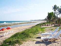
Beaches

- Camboa beach
Although deserted, this beach has in its 800 meters long, quiet, shallow waters, natural pools, coconut trees and mangal vegetation. The access is difficult due to the estuary of Merepe River, just by buggy, bike or walk from Cupé beach.
- Muro Alto beach
As Camboa is difficult to access, many visit Muro Alto, which has a wall of natural reefs about two km long, which form a huge natural pool without waves. Its name means High wall due to the presence of the high reefs, which is suitable for canoeing and kayaking. It has hotels and "pousadas" (Bed & Breakfast).
- Cupé beach
4.5 kilometers long beach involved in coconut trees, has numerous summer's houses, luxurious hotels, pousadas, hostels, bars and restaurants. Has one part of its coast protected by natural reefs, with the formation of natural pools. In the other part, where there are no reefs, the sea is choppy with strong waves, which requires care by the bathers.
- Porto de Galinhas beach
- Pontal de Maracaípe beach
It is a fluvial - marine beach at the estuary of the Maracaípe River. The predominant vegetation is mangue. The beach is often used for water sports such as canoeing and boat trips. Also, it is possible to find services to rent kayaks, banana boats and buggies.
- Maracaípe beach
It's suitable for surfing, has deep waters and huge waves. Maracaípe hosts a leg of the Brazilian Surf Tournament and one phase of the international surf calendar. There are coconut trees, and a mangal vegetation.
- Serrambi beach
It sought for scuba diving due to the presence in its waters of several shipwrecks (or remnants of them). The vessels are from different historical periods: from the Colonial Brazil period (500 years ago) until the major world wars. It has restaurants and bars.
Economy
The main economic activities in Ipojuca are based in tourism (with a large number of sophisticated internationals hotels and pousadas (traditional guest-houses)), commerce, food and general industry. The tourist sector has a boom every summer when thousands of people are in the famous beaches from everywhere in the world making it the coolest point of the metro area and the state. Ipojuca has also a very important Brazilian port - Suape port considered one of the most developded in Brazil and responsible for the boom in all industry sector in the whole state.
Economic Indicators
| Population | GDP x(1000 R$).[3] | GDP pc (R$) | PE | RMR |
|---|---|---|---|---|
| 75.512 | 5.354.635 | 76.418 | 8.76% | 13.32% |
| Primary sector | Secondary sector | Service sector |
|---|---|---|
| 0.54% | 27.59% | 71.87% |
Suape Harbour
Suape port is a Brazilian International Port located in Ipojuca - Pernambuco, among the municipalities of Ipojuca and Cabo de Santo Agostinho, inside the Recife metropolitan area and distant 40 km South of the capital (Recife). Suape serves ships 365 days a year without any restriction with regard to tidal schedules. Suape is one of the most important harbour and container terminals in northeast of Brazil playing an important role in the economy of the state of Pernambuco.[4] Suape has started in the 21st Century to be Pernambuco's motive power toward development. Huge national and international investments are being attracted by its logistic qualities, of which, until 2010, more than US$10 billion are expected.
Health Indicators
| HDI (2000)[5] | Hospitals (2007) | Hospitals beds (2007) | Children's Mortality every 1000 (2005) |
|---|---|---|---|
| 0.658 | 2 | 28 | 14.9 |
References
- ↑ http://www.ibge.gov.br/home/estatistica/populacao/estimativa2009/POP2009_DOU.pdf IBGE Population 2009 Ipojuca, page 33
- ↑ 11/11/2008 15:42:30. "Porto de Galinhas ж eleita melhor praia do Brasil pela oitava vez - Turismo nacional - Turismo - Notьcias - Fique por dentro - EcoViagem". Ecoviagem.uol.com.br. Retrieved 2016-05-25.
- ↑ Ipojuca 2007 GDP IBGE page 30
- ↑ SUAPE - Port and Industrial Complex
- ↑ PE State site - City by city profile
External links
| Wikivoyage has a travel guide for Ipojuca. |
- Video Ipojuca land of opportunities
- Videos about Porto de Galinhas beach: Video 1, Video 2, Video 3
- Surfing in Maracaípe beach
- Videos about Suape port complex: Video 1, Video 2