Inverness-shire
| Inverness-shire | |
|---|---|
 | |
| History | |
| • Created | Middle Ages |
| • Abolished | 1974 |
| • Succeeded by | Highland region |
| Status | County |
| Government | |
| • HQ | Inverness |
 | |
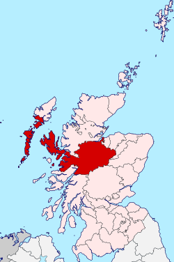
The Shire of Inverness (Scottish Gaelic: Siorrachd Inbhir Nis) is a former county or shire of Scotland. Covering much of the Highlands, it was geographically Scotland's largest county, though one of the smallest in terms of population, with 67,733 people or 1.34% of the national population.[1]
Definition
The extent of the lieutenancy area was defined in 1975 as covering the districts of Inverness, Badenoch & Strathspey, and Lochaber. Thus it differs from the county in that it includes parts of what were once Moray and Banffshire, but does not include any of the Outer Hebrides which were given their own lieutenancy area — the Western Isles.
Geography
Inverness-shire is Scotland's largest county, and the second largest in the UK as a whole after Yorkshire. It borders Ross to the north, Nairnshire, Moray, Banffshire and Aberdeenshire to the east, and Perthshire and Argyll to the south.
It covers a large mainland area and various island areas off the west coast. The mainland area has coastline in both the east and the west. The island areas include North Uist, South Uist and Harris in the Outer Hebrides and Skye and the Small Isles in the Inner Hebrides.
Principal settlements include Inverness, Fort William, Fort Augustus and Portree.
Coat of arms
Inverness-shire's coat of arms is blazoned:
- Azure, in dexter chief a stag's head and in sinister chief a bull's head both erased, and in base a galley, sails furled, oars in action and flagged, all Or. Beneath the shield an escrol bearing this motto: Air son Math na Siorrachd.
The galley represents Clan Chattan, who aligned themselves under the banner of Somerled, Lord of the Isles. The stag's head comes from the crest of the Frasers of Lovat, while the bull's head comes from the crest of the MacLeods of that Ilk. The motto is in Gaelic and means "For the Good of the County".
Local government
1890–1973
Inverness-shire acquired a county council in 1890, under the Local Government (Scotland) Act 1889, and, under the same legislation, boundaries were altered to make the county a single contiguous area, transferring several exclaves of other counties to Inverness-shire.
Although the new boundaries were supposed to be valid for all purposes (unlike earlier boundaries, which were really default boundaries and not necessarily those used for any particular purpose), the burghs of Inverness, Fort William, Kingussie, which had their own town councils, retained autonomous status and were for some purposes beyond the writ of the new county council. The town of Inverness had been established as a royal burgh since the mid 12th century, Fort William, originally a Fort of that name built by the Government to keep the Highlanders in their place, around which grew up a village which became in turn Gordonsburgh, Maryburgh, Duncansburgh and laterly the town/burgh of Fort William which had been established as a burgh of barony since 1618 and Kingussie had been established as a burgh of barony since 1464. Also, use of the new boundaries for parliamentary elections was specifically excluded.
1974–1995
The old county councils were abolished by the Local Government (Scotland) Act 1973 and Scotland was instead governed by a two-tier system of regions and districts. Mainland Inverness-shire was split amongst four districts of the Highland region, whilst the county's territory in the Outer Hebrides was transferred to the Western Isles council area.
- 1. The burgh of Inverness and the Aird and Inverness districts were merged to form the Inverness Local Government district of the Highland region.
- 2. The burgh of Fort William and the Lochaber district were merged with areas from the county of Argyll (the Ardnamurchan district and the electoral divisions of Ballachulish and Kinlochleven) to form the Lochaber district of the Highland region.
- 3. The Skye district was merged with an area from the county of Ross and Cromarty (the South West district) to form the Skye and Lochalsh district of the Highland region.
- 4. The burgh of Kingussie and the Badenoch district were merged with areas from the county of Moray (the burgh of Grantown-on-Spey and the Cromdale district) to form the Badenoch and Strathspey district of the Highland region.
- The Barra, Harris, North Uist, and South Uist districts were merged with areas from the county of Ross and Cromarty (the burgh of Stornoway and Lewis district) to form the Western Isles council area.
Within the Highland region, local government functions were divided between the regional council and the district councils. For example, education was a regional responsibility, and housing was a district responsibility.
1996–present
In 1996, under the Local Government etc (Scotland) Act 1994, the two-tier system was abolished and the Highland region became a unitary council area.
The new unitary Highland Council adopted the areas of the former districts as management areas. Each management area was represented, initially, by area committees consisting of councillors elected from areas (groups of local government wards) corresponding to the management areas, but changes to ward boundaries in 1999 created a mismatch between committee areas and management areas.
In 2007, at the time of further changes to ward boundaries, which created 22 multi-member wards instead of 80 single-member wards, the council created a new management structure, with three new corporate management areas and 16 new ward-level management areas. Also, four of the ward-level management areas, covering the seven wards, were grouped to form an Inverness city (or Inverness and Area) management area.
The total number of Highland councillors is 80, elected by the single transferable vote system of election, which is designed to produce a form of proportional representation. Wards in the Inverness city area elect 26 of the 34 council members elected from the Inverness, Nairn and Badenoch and Strathspey corporate management area.
The city area has the Nairn ward-level management area to the east, the Badenoch and Strathspey ward-level management area to the east and south, the Ross, Skye and Lochaber corporate management area to the south, west and north, and the Moray Firth to the north.
The city area is similar but not identical to the former district of Inverness.
| Ward[2] | Description | Seats | Ward-level management area |
|---|---|---|---|
| Aird and Loch Ness | Includes Loch Ness, the town of Beauly, and the village of Fort Augustus Aird is a former district of the county of Inverness |
4 | City area 1, covering the Aird and Loch Ness ward and a southern portion of the Inverness South ward |
| Culloden and Ardersier | Includes the villages of Culloden, Ardersier and Smithton | 4 | City area 4, covering the Culloden and Ardersier ward and a northern portion of the Inverness South ward |
| Inverness Central | Includes Dalneigh, Glebe, Haugh, Merkinch and South Kessock areas of urban Inverness | 4 | City area 3, covering the two wards of Inverness Central and Inverness Millburn |
| Inverness Millburn | Includes Millburn, Culcabock, Longman and Raigmore areas of urban Inverness | 3 | City area 3, covering the two wards of Inverness Central and Inverness Millburn |
| Inverness Ness-side | Includes Drummond, Hilton and Lochardil areas of Inverness, and a more rural area, east of the River Ness | 4 | City area 2, covering the two wards of Inverness Ness-side and Inverness West |
| Inverness South | Includes Cradlehall, Inshes and Westhill areas in or near urban Inverness, and the village of Tomatin, on the River Findhorn | 4 | Divided between city area 1, covering the Aird and Loch Ness ward and a southern portion of the Inverness South ward, and city area 4, covering the Culloden and Ardersier ward and a northern portion of the Inverness South ward |
| Inverness West | Includes Kinmylies and Scorguie areas of urban Inverness, and a more rural area, west of the River Ness | 3 | City area 2, covering the two wards of Inverness Ness-side and Inverness West |
Civil parishes
Civil parishes are still used for some statistical purposes, and separate census figures are published for them. As their areas have been largely unchanged since the 19th century this allows for comparison of population figures over an extended period of time.
In 1854 in Inverness-shire there were 29 civil parishes; 7 part civil parishes; and 5 parliamentary parishes.[3]
- Abernethy and Kincardine
- Alvie
- Ardersier
- Arisaig and Moidart
- Barra
- Boleskine and Abertarff
- Bracadale
- Cawdor part (now in Nairnshire)
- Cromdale Inverallan and Advie
- Croy, Highland and Dalcross, Highland
- Daviot
- Dunlichity
- Dores
- Duirinish
- Duthil and Rothiemurchus
- Glenelg
- Harris
- Inverness and Bona[4]
- Kilmallie
- Kilmonivaig
- Kilmorack
- Kilmuir
- Kiltarlity and Convinth
- Kingussie and Insh
- Kirkhill
- Laggan or Kinloch Laggan
- Moy and Dalarossie
- North Uist
- Petty
- Portree
- Sleat
- Small Isles
- Snizort
- South Uist
- Strath
- Urquhart and Glenmoriston
- Urray
Parliamentary constituencies
There was an Inverness-shire constituency of the Parliament of Great Britain (Westminster) from 1708 to 1801 and of the Parliament of the United Kingdom (also at Westminster) from 1801 to 1918. The constituency represented, nominally, the county of Inverness minus the parliamentary burgh of Inverness, which was represented as a component of the Inverness District of Burghs constituency.
In 1918 the county constituency was divided between two new constituencies, the Inverness constituency and the Western Isles constituency. The Inverness constituency included the burgh of Inverness, other components of the district of burghs being divided between the Moray and Nairn constituency and the Ross and Cromarty constituency.
In 1983, eight years after the local government county of Inverness had been divided between the Highland region and the Western Isles council area, three new constituencies were created to cover the Highland region. The region, until 1996, and the unitary Highland council area, 1996 to present, have been covered by three constituencies since then but there were changes to boundaries and names in 1997 and 2005.
In 1999 the areas of the Westminster constituencies became also constituencies of the Scottish Parliament (Holyrood). The boundaries of Scottish Parliament constituencies have not altered since then. The Holyrood constituencies are within the Highlands and Islands electoral region.
Since 1983, Inverness has appeared in the names of Westminster and Holyrood constituencies as tabled below.
Westminster constituencies
| Period | Constituency or constituencies |
|---|---|
| 1983 to 1997 | Inverness, Nairn and Lochaber |
| 1997 to 2005 | Ross, Skye and Inverness West |
| Inverness East, Nairn and Lochaber | |
| 2005 to present | Inverness, Nairn, Badenoch and Strathspey |
Holyrood constituencies
| Period | Constituencies |
|---|---|
| 1999 to present | Ross, Skye and Inverness West |
| Inverness East, Nairn and Lochaber |
Surnames
Most common surnames in Inverness-shire at the time of the United Kingdom Census of 1881,[5] by order of incidence:
| Wikimedia Commons has media related to Inverness-shire. |
| Wikimedia Commons has media related to Maps of Inverness-shire. |
Notes and references
- ↑ "The Area of Invernesshire". British Towns and Villages Network. 28 September 2014. Retrieved 29 December 2014.
- ↑ "Your Ward". Highland Council website. Retrieved 8 April 2008.
- ↑ Revd John Marius Wilson, ed. (1854). The Imperial gazetteer of Scotland. 2 (Gordon – Zetland). Edinburgh: A. Fullarton. p. 137. OL 14014352M.
- ↑ http://www.ambaile.org.uk/en/item/item_photograph.jsp?item_id=2580 Archived January 20, 2013, at the Wayback Machine.
- ↑ Most Common Surnames in Inverness-shire