Interstate H-3
| ||||
|---|---|---|---|---|
| John A. Burns Freeway | ||||
 | ||||
| Route information | ||||
| Maintained by HDOT | ||||
| Length: | 15.32 mi[1] (24.66 km) | |||
| Existed: | December 12, 1997 – present | |||
| Major junctions | ||||
| West end: |
| |||
|
| ||||
| East end: | Marine Corps Base Hawaii main gate | |||
| Highway system | ||||
| ||||

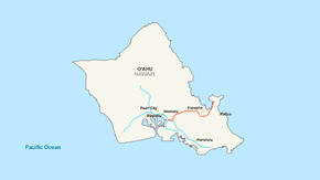
Interstate H-3 (abbreviated H-3) is an intrastate Interstate Highway located on the island of O'ahu in the state of Hawaii in the United States. H-3 is also known as the John A. Burns Freeway. It crosses the Ko'olau Range along a viaduct and through the 5,165-foot-long (1,574 m) Tetsuo Harano Tunnels as well as the much smaller Hospital Rock Tunnels.
Despite the number, signage is that of an east–west highway. Its western terminus is at an intersection of Interstate H-1 at Hālawa near Pearl Harbor. Its eastern end is at the main gate of Marine Corps Base Hawaii (MCBH). This route satisfies the national defense purpose of connecting the Marine Corps base with the U.S. Navy port at Pearl Harbor off Interstate H-1.
Orders for the freeway were granted in 1960, followed by planning stages. Construction, amid enormous community protest, was begun in the late 1980s, although the road did not open until December 12, 1997. Environmental complaints and legal challenges halted construction at many points. Construction resumed during the late 1980s due to an unprecedented move by U.S. Senator Daniel Inouye, who in 1986 had the freeway exempted from most environmental laws[2] as a rider on a Department of Defense budget bill.[3][4]
H-3 is one of the most expensive Interstate Highways ever built, on a cost per mile basis. Its final cost was $1.3 billion, or approximately $80 million per mile.[5]
Route description
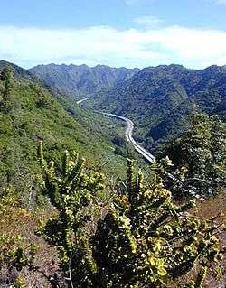
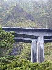
Interstate H-3 begins at the Hālawa Interchange with Interstates H-1 and H-201. The freeway then runs along a viaduct through Hālawa Valley for about 6 miles (9.7 km) until it reaches the Tetsuo Harano Tunnels through the Ko'olau Mountains. Once on the eastern end of the tunnel, the freeway follows a viaduct built along the side of Haiku Valley until the Kaneohe Interchange with State Route 63 (Likelike Highway) which leads into the town of Kaneohe. The freeway then continues to the Halekou Interchange with State Route 83 (Kamehameha Highway), then for four more miles until it reaches the main gate of Marine Corps Base Hawaii.
History

Since its inception in the early 1960s, the H-3 Freeway has been mired in controversy. The original route was not set to be in the current Halawa valley, but rather, the nearest major valley due east, in the Moanalua ahupuaʻa. The powerful Damon family hurried to create the Moanalua Gardens Foundation in 1970 to join the forces of all political and cultural groups who opposed the freeway's construction through their tract of land. The Foundation's pinnacle no-build argument was the need to remove a significant historical stone containing ancient petroglyphs, Pohaku ka Luahine, which, until this day, stands intact along the Moanalua valley trail. Success came their way as this freeway route was dropped, but the H-3 would merely be rerouted.
Kanaka Maoli cultural practitioners continue to call for the highway's removal since it runs through an area of extreme cultural significance, according to their interpretation. The Bishop Museum, which did the historical and archaeological research, has published extensive reports that generally ascribe lower cultural significance to these sites relative to other sites in Hawaii.[6][7] Many contend that the freeway is "cursed" due to its destruction of religious sites,[8][9] and is therefore harmful even to those who traverse it.[10][11] Ongoing environmental concerns include weed encroachment, light pollution, asbestos pollution, water and streamlife problems, and a host of other concerns; among these are the ongoing decline of native owls called pueo, and other native birds. For example, the Oʻahu ʻalauahio (Paroreomyza maculata), whose last known home was Halawa, has had no sightings since H-3 construction was completed.[6][12]
Some longtime residents of Koolaupoko and other East Shore communities continue to object to the freeway's developmental impacts on their communities. Among their primary fears are urbanization on the scale of Honolulu via the freeway, which has the potential to bring heavy traffic and growth into their traditionally quiet neighborhoods, as well as affecting the value of their homes in the relatively rural (until recently) communities.
Conversely, this road is considered an engineering wonder by its admirers. It is often compared to various cinematic landscapes in Star Wars and other movies, and it does sometimes reduce travel time for cross-island commuters, which has allowed for increased real estate development and prices in Windward Oʻahu.

One anecdote relates to the elevated section passing through Haʻikū Valley. In this valley, the viaduct passed beneath the antenna of a United States Coast Guard radio transmission facility. It was thought that the energy field from the antenna could interfere with heart pacemakers—a potential detriment to drivers and passengers on the roadway. A giant metal cage was designed to surround the roadway through the valley. Before H-3 was opened, the U.S. Coast Guard closed their transmitting facility, obviating the need for the cage. Although the full cage was never built, buried within the roadway was the bottom of the cage. HDOT decided to remove this steel mesh (at considerable expense) prior to opening of the freeway to minimize inconvenience to the motoring public at some later time.
Exit list
The entire route is in Honolulu County.
| Location | mi[13] | km | Exit | Destinations | Notes |
|---|---|---|---|---|---|
| Halawa | 0.00 | 0.00 | — | Left exit; westbound exit and eastbound entrance; western terminus; H-1 west exit 13B | |
| 1A | Westbound exit and eastbound entrance; H-1 east exit 13A | ||||
| 0.13 | 0.21 | 1B | H-201 east exit 1C, west exit 1D | ||
| 0.51 | 0.82 | 1C | Westbound exit only | ||
| Ko‘olau Range | Tetsuo Harano Tunnel | ||||
| Kaneohe | 8.23 | 13.24 | 9 | Eastbound exit and westbound entrance | |
| 9.91 | 15.95 | 11 | |||
| | 12.20 | 19.63 | — | ||
| | 14 | Eastbound exit and westbound entrance | |||
| Malae | 13.83 | 22.26 | 15 | Kaneohe Bay Drive | Roadway continues onto Kaneohe MCBH beyond Kaneohe Bay Drive |
| 1.000 mi = 1.609 km; 1.000 km = 0.621 mi | |||||
References
- ↑ Staff (October 31, 2002). "Table 1: Main Routes of the Dwight D. Eisenhower National System Of Interstate and Defense Highways as of October 31, 2002". Route Log and Finder List. Federal Highway Administration. Retrieved November 12, 2013.
- ↑ Kelly, Marjorie (September 1998). "E Luku Wale E: Devastation upon Devastation". Museum Anthropology. 22 (2): 57–62. doi:10.1525/mua.1998.22.2.57. Retrieved March 27, 2011.
- ↑ "Senate Amendment 3116 to House Joint Resolution 738, 99th Congress". United States Congress. October 2, 1986. Retrieved August 7, 2016.
- ↑ "Amendment No. 55: Interstate Highway H-3". Making Continuing Appropriations for Fiscal Year 1987 (Conference Report to H.J. Res. 738). United States Government Printing Office. October 15, 1986. pp. 783–784. Retrieved August 7, 2016 – via Internet Archive.
- ↑ Yuen, Mike (December 3, 1997). "H-3: Open Road". Honolulu Star-Bulletin. Retrieved March 27, 2011.
- 1 2 "Archaeological Projects Conducted by Bishop Museum for the Hawaiʻi State Department of Transportation and Federal Highways Administration for Interstate Route H-3". Bernice Pauahi Bishop Museum. Retrieved March 27, 2011.
- ↑ Trask, Haunani-Kay. "Stop H-3 Freeway sit-down protest, 1990s". Retrieved March 27, 2011.
- ↑ "H-3 Reports and Archives". Halawa-Luluku Interpretive Development Project. Archived from the original on July 26, 2011. Retrieved August 7, 2016.
- ↑ Hanlon, David (Spring 2001). "Review of Pana O'ahu: Sacred Stones, Sacred Land" (PDF). The Contemporary Pacific. 13: 293–5. doi:10.1353/cp.2001.0009. ISSN 1527-9464. Archived from the original (PDF) on August 29, 2004.
- ↑ Omandam, Pat (May 9, 1997). "Two points of view converge: Is H-3 trek a desecration or a celebration of the breathtaking beauty of Hawaii?". Hawaii Star-Bulletin.
- ↑ Omandam, Pat (December 4, 1997). "Even with the opening at hand, many Hawaiians say protests may not end". Hawaii Star-Bulletin.
- ↑ Melgar, Christian (2002). "Hawai'i's Endemic Forest Birds: Distribution, Status & Population Updates 2002". Birding Hawaii.
- ↑ Street Atlas USA (Map). DeLorme. 2007. Toggle Measure Tool.
External links
 Media related to Interstate H-3 at Wikimedia Commons
- H-3: The Island Interstate (1993)
| Signed | |||||||||||
|---|---|---|---|---|---|---|---|---|---|---|---|
| Unsigned | |||||||||||
| Lists |
| ||||||||||
Major Interstates highlighted | |||||||||||