Interstate 55 in Arkansas
| ||||
|---|---|---|---|---|
|
Route of I-55 in red | ||||
| Route information | ||||
| Maintained by AHTD | ||||
| Length: | 72.22 mi[1] (116.23 km) | |||
| Major junctions | ||||
| South end: |
| |||
|
| ||||
| North end: |
| |||
| Highway system | ||||
| ||||
.svg.png)
_map.svg.png)
Interstate 55 (I-55) is a north–south Interstate Highway that has a 72.22-mile (116.23 km) section in the U.S. state of Arkansas connecting sections in Tennessee and Missouri. The route enters Arkansas on the Memphis & Arkansas Bridge over the Mississippi River from Memphis. It travels northward through northeast Arkansas connecting the cities of West Memphis and Blytheville. I-55 continues into Missouri heading to St. Louis, Missouri. The highway overlaps Interstate 40 in West Memphis and has a junction with Interstate 555, a spur route to Jonesboro, in Turrell. For the majority of its routing through Arkansas, I-55 generally follows U.S. Route 61 (US 61) through Arkansas.
Route description
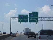
I-55 enters Arkansas from Memphis, Tennessee on the Memphis & Arkansas Bridge over the Mississippi River, sharing the bridge with US 61/US 64/US 70/US 79. Shortly after entering the state the highway enters West Memphis, where US 70 exits the route and becomes Broadway Avenue. I-55/US 61/US 64/US 79 form a concurrency with Interstate 40 at exit 5, an overlap that lasts 3.1 miles (5.0 km).[2] The highways split at I-40 exit 277, with I-40/US 63/US 79 continuing west to Little Rock and I-55/US 61/US 63/US 64 running north into Marion. US 64 exits I-55/US 61/US 63 in Marion, continuing west as Old Military Road toward Wynne. Interstate 55 continues to run through farmlands of the Arkansas delta, paralleling Highway 77 until Turrell.

In Turrell, I-55/US 61/US 63 meets the southern terminus of I-555, a spur route of I-55 connecting Jonesboro to the Interstate Highway system. I-555/US 63 run north to Jonesboro, while Highway 77 and US 61 become frontage roads for I-55. Slightly east of this junction these frontage roads depart I-55, with Highway 77 running near Birdsong and US 61 serving Wilson. I-55 runs northeast to enter Mississippi County, Arkansas, having junctions with Highway 118 to Joiner, Highway 181 to Bassett, Highway 14 near Marie, and Highway 181 near Keiser. In Osceola, the route has a junction with Highway 140 near Osceola Municipal Airport.[3] I-55 continues northeast, intersecting minor state highways in rural Mississippi County before a junction with US 61 in south Blytheville. Interstate 55 intersects Highway 18 in Blytheville before exiting town headed due north. The route has a junction with Highway 150 just before crossing the Missouri state line.
Exit list
| County | Location | mi | km | Exit | Destinations | Notes |
|---|---|---|---|---|---|---|
| Shelby | Memphis | Continuation into Tennessee | ||||
| Mississippi River | Memphis & Arkansas Bridge; Tennessee–Arkansas state line | |||||
| Crittenden | West Memphis | 1 | Bridgeport Road | |||
| 3A | Northbound exit only | |||||
| 3B | Northern end of US 70 overlap; northbound exit and southbound entrance | |||||
| 4 | Martin Luther King Jr. Drive, Southland Drive to I-40 east – Memphis | |||||
| - | Southern end of I-40 overlap, east exit 279B; northbound exit and southbound entrance. | |||||
| 5 | Ingram Boulevard | Southbound signed as Exit 279A | ||||
| 278 | AR 77 (Missouri Street) signed northbound only | |||||
| 7 | Southbound exit and northbound entrance | |||||
| | 8 | Northern end of I-40 and US 79 overlaps, Southern end of US 63 overlap, north exit 277 | ||||
| Marion | 10 | |||||
| | 14 | |||||
| | 17 | |||||
| | 21 | |||||
| Turrell | 23 | Northern end of US 61 and US 63 overlaps, exits 1A-B; signed as exits 23A (I-555/US 63/AR 77 north) and 23B (US 61/AR 77 south) southbound, no southbound entry from northbound AR 77. | ||||
| Mississippi | | 34 | ||||
| | 36 | |||||
| | 41 | |||||
| | 44 | |||||
| | 48 | |||||
| | 53 | |||||
| | 57 | |||||
| Blytheville | 63 | |||||
| 67 | ||||||
| | 71 | |||||
| | 72 | State Line Road | Northbound Exit and Entrance | |||
| | Continuation into Missouri | |||||
1.000 mi = 1.609 km; 1.000 km = 0.621 mi
| ||||||
References
- ↑ Planning and Research Division (March 28, 2012). "Arkansas Road Log Database" (MBD). Arkansas State Highway and Transportation Department. Retrieved April 13, 2012.
- ↑ General Highway Map, Crittenden County, Arkansas (PDF) (Map). 1:62500. Cartography by Planning and Research Division. Arkansas State Highway and Transportation Department. January 2, 2007. Retrieved April 26, 2012.
- ↑ General Highway Map, Mississippi County, Arkansas (PDF) (Map). 1:62500. Cartography by Planning and Research Division. Arkansas State Highway and Transportation Department. January 11, 2010. Retrieved April 26, 2012.
External links
![]() Media related to Interstate 55 in Arkansas at Wikimedia Commons
Media related to Interstate 55 in Arkansas at Wikimedia Commons
| Previous state: Tennessee |
Arkansas | Next state: Missouri |
Roads of Memphis | |||||||||||
|---|---|---|---|---|---|---|---|---|---|---|---|
| Interstate Highways | 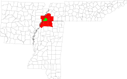 | ||||||||||
| U.S. Highways | |||||||||||
| State Highways |
| ||||||||||
| Other Highways | |||||||||||