Interstate 287
| |||||||
|---|---|---|---|---|---|---|---|
|
Map of New Jersey, Southern New York, and part of the Hudson Valley with I-287 highlighted in red | |||||||
| Route information | |||||||
| Auxiliary route of I‑87 | |||||||
| Maintained by NJDOT and NYSTA | |||||||
| Length: | 98.72 mi[1] (158.87 km) | ||||||
| Existed: | 1961 – present | ||||||
| Major junctions | |||||||
| South end: |
| ||||||
| |||||||
| East end: |
| ||||||
| Location | |||||||
| States: | New Jersey, New York | ||||||
| Counties: |
NJ: Middlesex, Somerset, Morris, Passaic, Bergen NY: Rockland, Westchester | ||||||
| Highway system | |||||||
| |||||||

_map.svg.png)
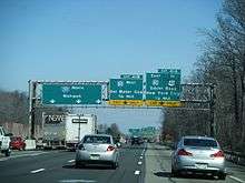
Interstate 287 (I-287) is an auxiliary Interstate Highway in the US states of New Jersey and New York. It is a partial beltway around New York City, serving the northern half of New Jersey and the counties of Rockland and Westchester in New York. I-287, which is signed north–south in New Jersey and east–west in New York, follows a roughly horseshoe-shaped route from the New Jersey Turnpike (I-95) in Edison Township, New Jersey, clockwise to the New England Thruway (I-95) in Rye, New York, for 98.72 miles (158.87 km). Through New Jersey, I-287 runs west from its southern terminus in Edison through suburban areas. In Bridgewater Township, the freeway takes a more northeasterly course, paralleled by U.S. Route 202 (US 202). The northernmost part of I-287 in New Jersey passes through mountainous surroundings. After crossing into New York at Suffern, I-287 turns east on the New York State Thruway (I-87) and runs though Rockland County. After crossing the Hudson River on the Tappan Zee Bridge, I-287 splits from I-87 near Tarrytown and continues east through Westchester County on the Cross-Westchester Expressway until it reaches the New England Thruway.
A bypass around New York City had been planned since the 1950s and would become a part of the Interstate Highway System and receive the I-287 designation. The Cross-Westchester Expressway, which was originally designated as Interstate 187, opened in 1960 as Interstate 487 before later becoming part of I-287. The New York State Thruway portion of I-287, which included a crossing of the Hudson River, opened in 1955. In New Jersey, the proposed I-287 had originally been designated as FAI Corridor 104 and incorporated what was planned as the Middlesex Freeway. The New Jersey section of I-287 between the New Jersey Turnpike in Edison and US 202 in Montville opened in stages between the 1960s and 1973; the remainder opened in 1994. The aging Tappan Zee Bridge is due to be replaced with a new span — construction started in 2013, with opening scheduled for 2017. In addition, a proposed tunnel across the Long Island Sound between Rye and Oyster Bay on Long Island would link the eastern terminus of I-287 to New York State Route 25 (NY 25) and NY 135 in Syosset.
Route description
| mi[1] | km | |
|---|---|---|
| NJ | 67.54 | 108.70 |
| NY | 31.18 | 50.18 |
| Total | 98.72 | 158.87 |
New Jersey
Middlesex County

I-287 begins at an interchange with the New Jersey Turnpike (I-95) in Edison in Middlesex County, New Jersey, where the freeway continues east as Route 440 towards Perth Amboy and Staten Island.[2][3] Within Middlesex County, I-287 is called the Lt. Col. (Ret) Richard F. Lauer, US Army Highway.[2] From this point, it heads west as an eight-lane freeway through suburban areas, soon reaching an interchange with US 1 that also has access to County Route 531 (CR 531) in the southbound direction. Past this point, the road turns more to the northwest as it comes to the junction with Route 27 (Lincoln Highway).[2][3] Following Route 27, I-287 narrows to six lanes and passes over Amtrak's Northeast Corridor as it continues to a southbound exit and northbound entrance with CR 501.[2]
As the freeway continues into South Plainfield, it passes near several business parks and comes to a partial interchange with Durham Avenue which only has a northbound exit and southbound entrance[2][3] At this point, the road starts to turn more west before it comes to a full junction with CR 529. Here, the road enters Piscataway Township and reaches an interchange with CR 665 (Washington Avenue).[2] Continuing near more business parks, I-287 comes to the exit for South Randolphville Road.[2][3] Following this interchange, the road heads west more before it turns to the southwest and comes to an interchange with the northern terminus of Route 18.[2] After Route 18, the freeway comes to the CR 622 (River Road) exit.[2][3]
Somerset County

After crossing over the Raritan River, I-287 enters Franklin Township, Somerset County and becomes the Captain (Ret) Joseph Azzolina, US Navy Highway. Soon after the river, there is an interchange with CR 527.[2] After CR 527, the freeway makes a turn to the northwest and passes a mix of residential areas and business parks.[3] The road has an interchange with CR 623 (Weston Canal Road) before crossing the Raritan River again and continuing into Bridgewater Township.[2] Within Bridgewater Township, I-287 curves north-northwest and passes over both New Jersey Transit's Raritan Valley Line and CR 533 near TD Bank Ballpark, which is home to the Somerset Patriots baseball team. Past this area, the road encounters Route 28 at an interchange.[2][3] Past Route 28, the freeway turns northwest and intersects US 22 at a partial interchange with a northbound exit and entrance and southbound entrance. From this point, I-287 makes a turn to the west and runs to the north of US 22 as it has a wide median.[2] The freeway turns northwest as it passes near the Bridgewater Commons shopping mall and reaches a partial interchange with US 202/US 206.[2][3] Through the remainder of New Jersey, US 202 will parallel the course of I-287.[3] At this point, I-287 gains a local-express lane configuration, with 3 local and 2 express lanes southbound and 3 express and 3 local lanes northbound. Both the southbound local and express lanes have access to southbound US 202/US 206 at this interchange, whereas northbound US 202/US 206 only has access to the local lanes of northbound I-287.[2]
From here, the road continues north past suburban residential areas, with the northbound direction narrowing to 2 local lanes, before entering Bedminster Township.[2][3] Here, I-287 intersects I-78 at the Vincent R. Kramer Interchange, where the local-express lane configuration ends. Access from eastbound I-78 to southbound I-287 is only to the local lanes. Meanwhile, the express lanes of northbound I-287 provides access to westbound I-78 while the local lanes provide access to eastbound I-78.[2] Following I-78, I-287 heads north with four northbound lanes and three southbound lanes into more wooded surroundings, reaching another interchange with US 202/US 206.[2][3] At this point, the freeway median widens again as it turns northeast before continuing more to the east and entering Far Hills. Within Far Hills, the road passes under CR 512 before the northbound direction narrows to three lanes and the wide median ends. Entering Bernards Township, I-287 runs east-northeast to an interchange with CR 525.[2] After the CR 525 interchange, the road gains a wide median that narrows again before the road runs under New Jersey Transit's Gladstone Branch, heading more to the northeast.[2][3] Before leaving Bernards Township, there is an exit for North Maple Avenue.[2]
Morris County
A short distance after this interchange, I-287 enters Harding Township, Morris County at the crossing of the Passaic River, where it becomes the Marine Hector Cafferata Jr. Cong. Medal of Honor Highway.[2] It continues northeast, with US 202 running a short distance to the west.[2][3] The freeway makes a turn more to the east as it comes to a truck-only rest area in the northbound direction.[3] The road crosses into Morris Township, where it reaches an exit-only interchange with Harter Road; there are no entrances present. Shortly after Harter Road, there is a junction with CR 663 (James Street) that only has entrances to I-287. After this, I-287 turns north and enters Morristown, where the northbound direction gains a fourth lane as the median narrows.[2] The freeway enters more developed areas as it comes to the Route 124 interchange. From this point, the road becomes eight lanes total, with four in each direction, as it passes west of Morristown Memorial Hospital.[2][3] After crossing under New Jersey Transit's Morristown Line, it reaches the exit for CR 510. From CR 510, I-287 makes a turn to the northeast, crossing back into Morris Township before continuing into Hanover Township. Here, the route comes to the western terminus of the Route 24 freeway.[2] Following Route 24, the freeway intersects Route 10. I-287 passes near several business parks as it enters Parsippany-Troy Hills. In this area, there is an interchange with CR 511 east of Lake Parsippany that also has access to Entin Road in the southbound direction. After this, I-287 widens to ten lanes with five northbound lanes, two express southbound lanes, and three local southbound lanes as it comes to the I-80 junction.[2][3]
Following this interchange, the freeway becomes six lanes, with three in each direction as it continues into more wooded areas and reaching an exit with access to US 46 and US 202/CR 511. In this area, the highway runs to the west of the Jersey City Reservoir and immediately to the east of US 202/CR 511.[2][3] I-287 comes to the Intervale Road exit, which carries US 202 and CR 511. The freeway enters Boonton, where it turns northeast, with New Jersey Transit's Montclair-Boonton Line located a short distance to the northwest.[2] In Boonton, there is another interchange with US 202/CR 511. From here, I-287 curves more to the east, with US 202 running immediately to the north of the road.[2][3] Along this stretch, there is an exit for US 202 and Vreeland Avenue.[2] Upon entering Montville, the freeway draws away from US 202 as it passes near wooded residential areas before coming to another interchange with US 202. I-287 continues northeast from this point, crossing under New Jersey Transit's Montclair-Boonton Line before running north-northeast through more woodland as the terrain starts to get more mountainous.[2][3] The freeway runs through Kinnelon, where the northbound direction has four lanes, and Pequannock Township before entering Riverdale. In Riverdale, there is an interchange with Route 23. A short distance later, I-287 reaches the CR 694 interchange which provides access to CR 511 Alternate.[2]
Passaic and Bergen counties
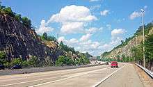
Immediately after this, I-287 crosses the Pequannock River into Bloomingdale, Passaic County, where the highway becomes US Air Force Gunner Clarence "Red" Mosley Highway.[2] The road continues northeast and turns north as it briefly passes through Pompton Lakes before crossing into Wanaque.[2][3] Here, the road makes a turn northeast again as it comes to the CR 511 Alternate interchange.[2] After this, I-287 passes through rock cuts in the Ramapo Mountains before making a sharp turn east as it crosses high above the Wanaque River valley on a bridge. The freeway continues into Oakland, Bergen County, where the name becomes Army Staff Sergeant Walter Bray Highway.[2][3]
Here, there are a couple of businesses near the road before the interchange with Skyline Drive. Following this, the road crosses the Ramapo River before passing near neighborhoods and reaching a junction with US 202.[2][3] After US 202, I-287 turns southeast and closely parallels the New York, Susquehanna and Western Railway line to the southwest before entering Franklin Lakes and coming to an interchange with the northern terminus of Route 208.[2] Past this interchange, I-287 narrows to four lanes and turns northeast as the railroad line draws away. The freeway passes wooded residential neighborhoods prior to turning north and entering Mahwah Township, where it continues near more wooded suburban areas as well as the Campgaw Mountain Reservation to the west of the road. After passing to the east of the Ramapo College of New Jersey campus, I-287 passes over US 202.[2][3] The freeway crosses the Ramapo River again before reaching an interchange with Route 17.[2] At this point, Route 17 forms a concurrency with I-287 and the road widens to six lanes as it passes between the Ramapo Valley County Reservation to the west and business parks to the east.[2][3]
New York
New York State Thruway

Upon entering New York in the Village of Suffern in the Town of Ramapo in Rockland County, New York, New Jersey's Route 17 ends and NY 17 follows I-287 as the road comes to an interchange with the New York State Thruway (I-87).[4][5] At this point, I-287 joins I-87 on the eight-lane New York State Thruway, passing over Metro-North Railroad's Port Jervis Line as it heads east out of the mountains into suburban residential and commercial surroundings as it narrows to six lanes.[3][4] After passing through the Village of Montebello, the freeway reaches an interchange with Airmont Road where it becomes the border between Montebello to the north and the Village of Airmont to the south.[4][5] Continuing to the east, the New York State Thruway becomes the border between Monsey and Airmont before separating Monsey from the Village of Chestnut Ridge to the south as it turns slightly to the east-southeast.[5] After briefly running along the south edge of the Village of Spring Valley, where there is a westbound toll plaza for trucks, the highway fully enters Chestnut Ridge.[3][5] In this area, it comes to the New York extension of the Garden State Parkway.[4] Following this junction, I-87/I-287 continues east into the Town of Clarkstown, coming to an exit for NY 59.[4][5] After this, the road passes to the north of Nanuet, crossing under New Jersey Transit/Metro-North Railroad's Pascack Valley Line.[3][5] The freeway crosses under NY 304 before the cloverleaf interchange with the Palisades Interstate Parkway. As the Thruway continues into West Nyack, it comes to the exit for NY 303 that provides access to the Palisades Center shopping mall to the south of the road.[3][4]
Past NY 303, I-87/I-287 turns to the east-southeast and passes near wooded areas as well as suburban neighborhoods of Central Nyack.[3][5] It comes to another interchange with NY 59 that also provides access to US 9W.[4][5] At this point, the New York State Thruway widens to eight lanes and turns to the south-southeast into the Village of Nyack in the Town of Orangetown, crossing over US 9W prior to passing near residential areas in the Village of South Nyack as it runs to the east of US 9W, descending The Palisades.[3][5] The last interchange in Rockland County is with US 9W and has no southbound exit.[3][4] From here, the New York State Thruway crosses the Hudson River on the Tappan Zee Bridge east into the Village of Tarrytown in the Town of Greenburgh in Westchester County.[3][5] After passing over the river, the road crosses over Metro-North Railroad's Hudson Line before coming to an eastbound toll plaza.[3] After this, the freeway comes to the exit for US 9 that also serves the western terminus of NY 119.[4][5] I-87/I-287 continue east past woodland and business parks, leaving Tarrytown before coming to an interchange where the two routes split, with I-87 continuing south on the New York State Thruway and I-287 heading east on the Cross-Westchester Expressway.[3][4][5] This interchange also has access to and from the northbound Saw Mill River Parkway and NY 119.[3]
Cross-Westchester Expressway
The Cross-Westchester Expressway, which is maintained by the New York State Thruway Authority, is six lanes wide and carries I-287 east to a westbound exit for NY 119 that is intertwined with the ramps between the New York State Thruway and NY 119/Saw Mill River Parkway.[3][4][6] After passing over the Saw Mill River Parkway and the Saw Mill River, the road enters the Village of Elmsford and runs through developed areas as it has a partial diamond interchange with NY 9A that does not have an eastbound exit.[3][4][5] The Cross-Westchester Expressway turns southeast from this point and intersects the Sprain Brook Parkway.[4][5] I-287 widens to eight lanes at this junction and continues to the exit for NY 100A.[3][4] After the NY 100A interchange, the freeway leaves Elmsford and turns to the east near residential areas, narrowing to six lanes before coming to an exit for NY 100 and NY 119 that also has access to the Bronx River Parkway.[3][4][5]
Following this exit, the road becomes eight lanes again and crosses over the Bronx River Parkway, the Bronx River, and Metro-North Railroad's Harlem Line.[3][5] Here, the road crosses into White Plains and reaches an interchange with NY 22.[4][5] Past NY 22, I-287 makes a sharp curve to the south as it narrows to six lanes and runs near inhabited neighborhoods.[3] The road has a westbound exit and eastbound entrance with the Central Westchester Parkway, a road that provides access to the Taconic State Parkway by way of NY 22. The freeway runs past commercial areas to the east of downtown White Plains as it encounters Westchester Avenue, which connects to NY 119, NY 127, and Anderson Hill Road as well as The Westchester shopping mall in the downtown area.[3][4] Within this interchange, the Cross-Westchester Expressway turns east along the border between Harrison to the north and White Plains to the south.[5] Westchester Avenue becomes a frontage road for I-287 as the road passes corporate parks to the north and populated neighborhoods to the south.[3]
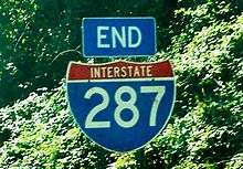
The road begins to turn southeast as it comes to a directional interchange with the southern terminus of I-684.[3][4] The I-287 freeway heads south along the White Plains/Harrison border before turning east and fully entering Harrison, where there is a cloverleaf interchange with the Hutchinson River Parkway.[3][4][5] At this interchange, the Westchester Avenue frontage road serves as a collector/distributor road. The Cross-Westchester Expressway turns southeast again past wooded areas of development, with NY 120 coming onto the Westchester Avenue frontage road.[3] I-287 reaches an interchange where the frontage road ends as Westchester Avenue heads east as NY 120A and NY 120 continues to the south.[3][4] Here, the freeway enters the Village of Rye Brook in the Town of Rye as it continues southeast.[5] The Cross-Westchester Expressway comes into the Village of Port Chester, where the road runs near more dense suburban development as it intersects US 1.[3][4][5] At this point, the road has ramp access to and from the southbound direction of the New England Thruway (I-95).[3] From here, the mainline I-287 narrows to four lanes and enters the City of Rye, where it passes over the Northeast Corridor before merging into northbound I-95 about a half-mile (800 meters) west of the Connecticut state line.[3][4][5]
History
New Jersey
In the 1950s, a limited-access highway was proposed to bypass New York City.[7] This planned beltway would be incorporated into the new Interstate Highway System.[8] The proposed beltway in New Jersey was designated as FAI Corridor 104 and later received the I-287 designation in 1958.[9] The southern segment of I-287 was planned in the 1950s as the Middlesex Freeway, which was to run from the Outerbridge Crossing to Staten Island and follow the Route 440 corridor to Edison, where it would connect to the New Jersey Turnpike before continuing west to I-78. From here, the freeway would parallel US 202 north to the New York border. The anticipated cost of building I-287 in New Jersey was $235 million.[10] The southernmost part of I-287 in Middlesex County was to be cosigned with I-95; this never happened due to the cancellation of the Somerset Freeway.[11][12] By the mid-1960s, I-287 had been completed between the New Jersey Turnpike and Bedminster Township and from US 46 in Parsippany to US 202 in Montville.[13] More of I-287 in New Jersey had been finished by 1969, with the sections from US 46 south to Route 10 in Hanover Township and from Bedminster Township north to Maple Avenue in Bernards Township opened.[11] The segment of the highway between Maple Avenue and Route 10 opened in 1973, making I-287 a continuous road between the New Jersey Turnpike in Edison and US 202 in Montville.[14]

I-287's missing section between US 202 in Montville and the New York State Thruway in Suffern, NY was controversial dating back to 1965 and continuing until its opening in 1993. Property owners along the proposed route fought its completion as part of the freeway revolts of the 1960s and 1970s.[7] Originally, I-287 was proposed to take a more eastern route through the Lincoln Park and Wayne areas; this routing gained opposition as it passed through populated areas.[11][15] A more western alignment was planned through mountainous areas in 1973, but this was rejected as the cost of building the road through the mountains was too high.[15] In 1977, the current alignment of I-287 was proposed between Montville and Suffern; this was approved by the federal government in 1982 as it was less costly than the western alignment and went through less developed areas than the eastern alignment.[16][17]
Permits allowing construction to begin on this segment were issued in 1988 by the Army Corps of Engineers. Officials in Rockland County, New York filed a lawsuit on November 19, 1993, hours before the highway's official ribbon-cutting, seeking to block its opening. They claimed the incomplete interchange with the New York State Thruway was inadequate to handle the additional traffic.[7] That interchange was not complete until 1994, but the highway opened as planned on November 19 in a ceremony held on the Wanaque River bridge, where New Jersey Governor Jim Florio cut the ribbon.[7][18] This moment marked the completion of a bypass around New York City that had been planned for decades.[7] The portion of I-287 between the US 202 interchange in Oakland and the Route 208 interchange in Franklin Lakes overtook the westernmost portion of Route 208, truncating that route to its current location.[11][19]
The completion of I-287 in New Jersey had significant effects on traffic and development patterns in the area. Several towns along the highway, such as Wanaque and Montville, saw increases in development. In addition, as the road was a bypass, it saw a significant increase in truck traffic wishing to bypass congested roads closer to New York City.[18] The road also increased truck traffic on other north–south corridors, such as Route 31, from truckers wanting to bypass the New Jersey Turnpike by using these surface roads to get between the I-287 bypass of New York City and I-95 south to Pennsylvania.[18][20] On July 16, 1999, Governor Christine Todd Whitman banned oversize trucks from using roads that are not part of the National Highway System, such as Route 31. Trucks were therefore forced to use I-287 and the New Jersey Turnpike to travel across the state.[21] In the 1990s, high-occupancy vehicle lanes were built along I-287 between Bedminster and Parsippany. These HOV lanes, along with the ones that had been built on I-80, were opened to all traffic in 1998 due to lack of HOV usage, and the state did not have to repay the federal government the $240 million to build the lanes.[22] In 2011, a small section of the northbound side of the highway in Boonton collapsed into the Rockaway River due to Hurricane Irene.[23] Near the end of that year, five people and a dog were killed when a small SOCATA TBM 700 airplane en route to Georgia crashed on the highway near exit 33 in Morris Township.[24]
New York State Thruway

The New York State Thruway portion of I-287 was planned around 1950 as part of a tolled limited-access highway that was to connect the major cities of New York.[25][26] A bridge across the Hudson River was planned between Nyack and Tarrytown at a site that was close enough to New York City but far enough from the Port Authority of New York and New Jersey's jurisdiction area, as they opposed the crossing.[27] The portion of the thruway currently followed by I-287, including the Tappan Zee Bridge over the Hudson River, opened on December 15, 1955.[28][29] In the 1960s, I-287 was designated along the New York State Thruway between Suffern and Tarrytown, while I-87 ran farther to the east on present-day I-684.[13] On January 1, 1970, the I-87 designation was shifted onto this portion of the New York State Thruway to run concurrent with I-287.[30]
The E-ZPass electronic toll collection system was first introduced on this segment of the Thruway at the Spring Valley and Tappan Zee Bridge toll plazas in 1993.[31] The same year, an interchange in Suffern opened providing access to the newly opened New Jersey portion of I-287.[32] In 1997, tolls for cars were eliminated at the Spring Valley toll plaza, with tolls remaining for trucks and other commercial vehicles.[33] The I-87/I-287 interchange split near Tarrytown began a $187 million reconstruction in 2001 in order to add additional lanes and rebuild overpasses and underpasses.[34] Reconstruction in this area was completed in May 2004.[35]
Cross-Westchester Expressway
Plans for a limited-access road to cross Westchester County east to west date back to the 1920s and became more needed after post-World War II traffic increases. When the Tappan Zee Bridge was proposed around 1950, the Cross-Westchester Expressway was becoming a more realistic idea.[26] Construction of the freeway began in 1956, and was given the NY 119 designation. The design of the highway met Interstate highway standards after opening, and was supposed to have the I-187 designation. However, by the time the highway opened, it was officially designated as I-487 instead. At a cost of $50 million, the Cross Westchester Expressway was opened December 1960.[36] Later in the 1960s, this segment of road was redesignated I-287 to make it a part of the beltway around New York City.[13]
I-287 was to continue past I-95 in Port Chester and was to cross Long Island Sound via the unbuilt Oyster Bay–Rye Bridge.[37][38] On Long Island, the route would run along the Seaford–Oyster Bay Expressway (NY 135). Then, I-287 was again to be extended into Jones Beach by merging with the Wantagh State Parkway in Merrick. The plans for the bridge, and the I-287 extension onto Long Island, were dropped in 1973 by Governor Nelson Rockefeller as a result of community opposition and environmental concerns.[39]
Ownership of the Cross-Westchester Expressway was transferred from the New York State Department of Transportation to the New York State Thruway Authority in 1990 to help relieve the state's budget issues.[40] On July 27, 1994, a propane truck crashed into an overpass on the Cross-Westchester Expressway in White Plains and exploded, killing the driver. The fire from the explosion spread into adjacent neighborhoods and injured 23 people.[41] In the mid-1990s, a reversible high-occupancy vehicle lane was proposed for the Cross-Westchester Expressway in order to alleviate congestion at a planned cost of $365 million. In addition, a Metro-North Railroad line and a guided busway were considered to serve the I-287 corridor in Westchester County as alternatives to the HOV lane.[42] The proposed HOV lane was cancelled in 1997 by Governor George Pataki out of the fear it would have negative effects on the area in trying to solve traffic.[43] Since 1999, the Cross-Westchester Expressway has been under construction in order to reduce congestion and improve safety for the motorists who use the highway.[44] The final phase of the project, a reconstruction in the area of exit 8 in White Plains, was completed in December 2012, nine months ahead of schedule.[45]
Future
Tappan Zee replacement
Due to the congestion along I-87/I-287 and the aging and decay of the over fifty-year-old Tappan Zee Bridge, talks have begun regarding the possibility of replacing the bridge.[46] A variety of transportation improvements are currently being considered, including a Metro-North Railroad commuter rail system or a bus rapid transit system that would link the western shore of the Hudson River with Westchester County and New York City. In addition, several alternatives are being considered for traffic management on the bridge, including high-occupancy toll lanes, park and ride lots, ramp meters, and congestion tolling at peak times.[47] Several designs for the new bridge, which is to be north of the existing structure, included suspension, cantilever, and cable-stayed spans.[48] Construction on the new bridge began in 2013, with opening targeted for 2017.
Improvements in New Jersey
NJDOT started the I-287 (Middlesex Freeway) Rehabilitation Project in August 2007 to resurface the pavement between exit 5 in South Plainfield and I-95/New Jersey Turnpike in Edison Township, which is used by about 150,000 vehicles daily. Some of the bridges and overpasses had deteriorated to such a state that they needed to be replaced.[49] On September 16, 2009, NJDOT announced the start of another rehabilitation and repaving project from exit 5 in Piscataway to the area of exit 10 in Franklin Township. This project, which is being funded by the American Recovery and Reinvestment Act of 2009, is to cost $29 million and is expected to be finished later in 2011.[50]
Proposed crossing to Long Island
In 2008, a private firm, Polimeni Associates, proposed to construct a more than 16-mile-long (26 km) tunnel across Long Island Sound between Rye and Oyster Bay.[51] This proposed tunnel would be the longest highway tunnel in the world, with its length exceeding that of the Lærdalstunnelen in Norway by a mile.[52] It would start at the junction with the Cross Westchester Expressway and the New England Thruway in Rye and end at NY 135 and NY 25 in Syosset.[53] Estimated to cost approximately $10 billion, it would feature three tubes: the outer tubes would have three lanes of vehicular traffic each and the inner tube would be used for maintenance.[52] The proposed tunnel, which is to be operated by a private firm, is still awaiting approval to begin construction.[54]
Exit list
| State | County | Location | mi [2][4] | km | Exit | Destinations | Notes |
|---|---|---|---|---|---|---|---|
| New Jersey | Middlesex | Edison Township | 0.00 | 0.00 | – | Southern terminus of Route 440 | |
| – | Exit 10 on I-95 / NJ Turnpike | ||||||
| 0.93 | 1.50 | 1 | Signed as exits 1A (north) and 1B (south); no direct northbound access to CR 531 | ||||
| 2.24 | 3.60 | 2 | Northbound exit and southbound entrance; signed as exits 2A (north) and 2B (south) | ||||
| 3.09 | 4.97 | 3 | Southbound exit and northbound entrance | ||||
| South Plainfield | 4.62 | 7.44 | 4 | Durham Avenue – South Plainfield | Northbound exit and southbound entrance | ||
| South Plainfield–Piscataway Township line | 5.88 | 9.46 | 5 | ||||
| Piscataway Township | 6.41 | 10.32 | 6 | Washington Avenue – Piscataway, Dunellen | No southbound entrance | ||
| 7.27 | 11.70 | 7 | South Randolphville Road – Piscataway, Middlesex | ||||
| 8.47 | 13.63 | 8 | Northbound exit and entrance | ||||
| 8.47 | 13.63 | 8 | Southbound exit and entrance | ||||
| 9.95 | 16.01 | 9 | River Road (CR 622) – Bound Brook, Highland Park | ||||
| Somerset | Franklin Township | 10.27 | 16.53 | 10 | |||
| 12.30 | 19.79 | 12 | Weston Canal Road (CR 623) – Manville, South Bound Brook | ||||
| Bridgewater Township | 13.50 | 21.73 | 13 | Signed as exits 13A (east) and 13B (west) northbound | |||
| 14.24 | 22.92 | 14A | No northbound entrance | ||||
| 14.35 | 23.09 | 14B | No southbound exit | ||||
| 17.86 | 28.74 | 17 | Southbound exit and northbound entrance | ||||
| Bedminster Township | 21.17 | 34.07 | 21 | Signed as exits 21A (east) and 21B (west) | |||
| 22.21 | 35.74 | 22 | Signed as 22A (south) and 22B (north) | ||||
| Bernards Township | 26.48 | 42.62 | 26 | Signed as exits 26A (south) and 26B (north) northbound | |||
| 29.94 | 48.18 | 30A | North Maple Avenue – Basking Ridge | ||||
| 29.94 | 48.18 | 30B | |||||
| Morris | Morris Township | 34.02 | 54.75 | 33 | Harter Road | Entrances from CR 663 | |
| Morristown | 35.77– 35.89 | 57.57– 57.76 | 35 | ||||
| 36.39– 36.60 | 58.56– 58.90 | 36 | Signed as exits 36A (east) and 36B (west) northbound | ||||
| Hanover Township | 37.92– 38.00 | 61.03– 61.16 | 37 | Western terminus of Route 24 | |||
| 39.55 | 63.65 | 39 | |||||
| Parsippany-Troy Hills | 40.94 | 65.89 | 40 | No access from southbound entrance of exit 41B. Signed as exits 40A (Parsippany Rd.) and 40B (Entin Rd.) southbound | |||
| 42.02 | 67.62 | 41 | Signed as exits 41A (east) and 41B (west); exit 43 on I-80 | ||||
| 42.74 | 68.78 | 42 | No northbound exit | ||||
| 44.06 | 70.91 | 43 | Intervale Road (US 202) – Mountain Lakes | Northbound exit and southbound entrance. Southbound entrance via Parsippany Blvd. | |||
| Boonton | 44.95 | 72.34 | 44 | Main Street (US 202) – Boonton | Northbound exit and southbound entrance | ||
| 45.68 | 73.51 | 45 | Myrtle Avenue (US 202) / Wootton Street – Boonton | ||||
| Montville Township | 47.11 | 75.82 | 47 | ||||
| Riverdale | 53.14 | 85.52 | 52 | Signed as exits 52A (south) and 52B (north) | |||
| 53.83 | 86.63 | 53 | |||||
| Passaic | Wanaque | 55.31 | 89.01 | 55 | |||
| Bergen | Oakland | 58.13 | 93.55 | 57 | Skyline Drive (CR S-91) – Ringwood | ||
| 58.86 | 94.73 | 58 | |||||
| Oakland–Franklin Lakes line | 59.94 | 96.46 | 59 | Northern terminus of Route 208 | |||
| Mahwah Township | 66.95 | 107.75 | 66 | South end of concurrency with Route 17 | |||
| New Jersey–New York state line | 67.54 0.00 | 108.70 0.00 | Route 17 becomes NY 17 | ||||
| New York | Rockland | Suffern | 0.11– 0.65 | 0.18– 1.05 | - | North end of concurrency with NY 17; west end of concurrency with I-87 / Thruway | |
| 3.47 | 5.58 | 14B | Access to Good Samaritan Regional Medical Center | ||||
| 6.78 | 10.91 | Spring Valley Toll Barrier (westbound commercial vehicles only) | |||||
| 7.56 | 12.17 | 14A | Northern terminus of the Garden State Parkway Connector | ||||
| Clarkstown | 8.29 | 13.34 | 14 | ||||
| 10.15 | 16.33 | 13 | Signed as exits 13N (north) and 13S (south); exit 9 on Palisades Parkway | ||||
| 12.33 | 19.84 | 12 | |||||
| Nyack | 13.49 | 21.71 | 11 | ||||
| South Nyack | 14.34 | 23.08 | 10 | No eastbound exit | |||
| Hudson River | Tappan Zee Bridge | ||||||
| Westchester | Tarrytown | 18.02 | 29.00 | Tappan Zee Bridge Toll Barrier (eastbound only) | |||
| 18.24 | 29.35 | 9 | |||||
| Greenburgh | 19.78 | 31.83 | 8 | East end of concurrency with I-87 / Thruway; no exit number westbound | |||
| Elmsford | 20.55 | 33.07 | 1 | Eastbound exit is signed as exit 8A of I-87 / Thruway; access to Saw Mill Parkway north via NY 119 east | |||
| 21.23 | 34.17 | 2 | No eastbound exit | ||||
| 3 | No eastbound access to Sprain Brook Parkway north | ||||||
| 22.20 | 35.73 | 4 | |||||
| Greenburgh | 23.01 | 37.03 | 5 | Access to Bronx River Parkway; no direct access westbound exit to NY 119 | |||
| White Plains | 24.10 | 38.79 | 6 | ||||
| 7 | Central Westchester Parkway north – Valhalla | Westbound exit and eastbound entrance | |||||
| White Plains–Harrison city/village line | 25.43 | 40.93 | 8 | Signed as 8W (west) and 8E (east) eastbound; NY 127 not signed westbound | |||
| 26.69 | 42.95 | 9A | No westbound access to Westchester Avenue | ||||
| Harrison | 27.87 | 44.85 | 9 | Signed as 9S (south) and 9N (north); Westchester Avenue acts as a collector/distributor road | |||
| 28.57 | 45.98 | 10 | Eastbound exit, no entrance | ||||
| 28.57 | 45.98 | 10 | Bowman Avenue / Webb Avenue | Westbound exit and entrance | |||
| Rye–Port Chester city/village line | 30.67 | 49.36 | 11 | Eastbound exit and westbound entrance | |||
| City of Rye | 31.11 | 50.07 | 12 | Eastbound exit, westbound entrance and exit | |||
| 31.11 | 50.07 | 13 | Midland Avenue – Port Chester, Rye | Westbound exit and entrance | |||
| 31.11 | 50.07 | – | Exit 21 on I-95 | ||||
1.000 mi = 1.609 km; 1.000 km = 0.621 mi
| |||||||
References
- 1 2 "Route Log and Finder List – Interstate System: Table 2". FHWA. Retrieved October 8, 2007.
- 1 2 3 4 5 6 7 8 9 10 11 12 13 14 15 16 17 18 19 20 21 22 23 24 25 26 27 28 29 30 31 32 33 34 35 36 37 38 39 40 41 42 43 "I-287 Straight Line Diagram" (PDF). New Jersey Department of Transportation. Retrieved December 18, 2009.
- 1 2 3 4 5 6 7 8 9 10 11 12 13 14 15 16 17 18 19 20 21 22 23 24 25 26 27 28 29 30 31 32 33 34 35 36 37 38 39 40 41 42 43 44 45 46 47 48 49 50 Google (December 18, 2009). "overview of Interstate 287" (Map). Google Maps. Google. Retrieved December 18, 2009.
- 1 2 3 4 5 6 7 8 9 10 11 12 13 14 15 16 17 18 19 20 21 22 23 "2008 Traffic Data Report for New York State" (PDF). New York State Department of Transportation. June 16, 2009. p. 201. Retrieved December 8, 2009.
- 1 2 3 4 5 6 7 8 9 10 11 12 13 14 15 16 17 18 19 20 21 22 New York State Road Atlas (Map). Hagstrom Map. 2001.
- ↑ "Interchange/Exit Listing with Mileposts". New York State Thruway Authority. Retrieved December 20, 2009.
- 1 2 3 4 5 "Missing Link of Interstate Opens, Despite Lawsuit". The New York Times. November 20, 1993. Retrieved December 22, 2009.
- ↑ General Location of National System of Interstate Highways in New York, New York (Map). Bureau of Public Roads. 1955. Retrieved December 22, 2009.
- ↑ Wright, George Cable (September 19, 1958). "New Roads with New Numbers Will Parallel Old U.S. Routes". The New York Times.
- ↑ Middlesex Freeway. New Jersey State Highway Department. 1956.
- 1 2 3 4 Map of New Jersey (Map). Cartography by H.M. Gousha. Chevron Oil Company. 1969.
- ↑ "Governor Byrne Cancels I-95 Through Central Jersey". The New York Times. May 4, 1980.
- 1 2 3 United States featuring the Interstate Highway System (Map). Cartography by General Drafting. Esso. 1966.
- ↑ Gansberg, Martin (April 1, 1973). "A New Highway Irks Morristown". The New York Times.
- 1 2 "Route I-287: Change Unlikely; Alternate Proposal". The New York Times. June 17, 1973.
- ↑ Hanley, Robert (October 4, 1977). "New Route Proposed for I-287 Extension; Rep. Roe Suggests Plan to Avoid More Populous Corridor Fought for Years by Local Groups". The New York Times.
- ↑ "U.S. Approves Jersey Link to Thruway". The New York Times. Associated Press. September 4, 1982.
- 1 2 3 Perez-Pena, Richard (June 2, 1996). "I-287: Extend It and They Will Drive on It; A New 20-Mile Stretch Has Changed Traffic Patterns in Unintended Ways". The New York Times. Retrieved December 22, 2009.
- ↑ United States-Canada-Mexico Road Atlas (Map). Rand McNally. 1996.
- ↑ Newman, Andy (July 23, 1995). "Road and Rail; Truckers Carve a New Route, Crowding a Two-Lane Road". The New York Times. Retrieved December 11, 2008.
- ↑ Futterman, Matthew (July 17, 1999). "NJ Bars Huge Rigs on Most Highways". The Star-Ledger. Newark, NJ.
- ↑ Berger, Joseph (December 1, 1998). "Our Towns; H.O.V. Lanes: A 30-Mile Test That Failed". The New York Times. Retrieved December 22, 2009.
- ↑ Frassinelli, Mike. "Hurricane Irene wreaks havoc on New Jersey highways". The Star-Ledger. NJ.com. Retrieved August 20, 2011.
- ↑ "5 victims in I-287 plane crash are identified". The Star-Ledger. December 20, 2011. Retrieved December 20, 2011.
- ↑ Highway Needs in New York State. New York State Department of Public Works. February 21, 1950.
- 1 2 Pomeroy, Hugh R. (February 21, 1950). Let's Be Realistic About Thruways. Westchester County Planning Department.
- ↑ Brenner, Elsa (April 30, 2000). "Future of Bridge Stirs Bicounty Cooperation". The New York Times. Retrieved December 22, 2009.
- ↑ Ingraham, Joseph C. (December 4, 1955). "Thruway Jumps the Hudson River to Yonkers". The New York Times.
- ↑ Ingraham, Joseph C. (August 26, 1956). "Thruway Through". The New York Times.
- ↑ State of New York Department of Transportation (January 1, 1970). Official Description of Touring Routes in New York State (PDF). Retrieved January 28, 2010.
- ↑ Steinberg, Jacques (September 10, 1993). "Nonstop Toll Is Approved For Bridge". The New York Times. Retrieved December 22, 2009.
- ↑ Hershenson, Roberta (October 5, 1997). "The Task of Finding Viable Alternatives To the Automobile". The New York Times. Retrieved December 22, 2009.
- ↑ "Tappan Zee Car Toll To Rise to $3 in July". The New York Times. January 28, 1997. Retrieved December 22, 2009.
- ↑ Zhao, Yilu (August 24, 2003). "Slow Down: Construction Ahead". The New York Times. Retrieved December 22, 2009.
- ↑ Halbfinger, Caren (May 29, 2004). "New Lane Opens on 287". The Journal News. White Plains, NY.
- ↑ "Westchester Expressway Link Opens Soon, Ahead of Schedule". The New York Times. December 2, 1960.
- ↑ Moses, Robert (1966). Proposed Bayville–Rye Bridge. Nassau–Suffolk Regional Planning Board.
- ↑ Moses, Robert; Federal Highway Administration, Metropolitan Transportation Authority and New York State Department of Transportation (November 1972). "Oyster Bay–Rye Bridge, Administrative Action Final Environmental Impact Statement and Section 4(f) Statement". Federal Highway Administration, Metropolitan Transportation Authority, and New York State Department of Transportation.
- ↑ "Governor To Cease Efforts To Build LI Sound Bridge". The New York Times. June 21, 1973.
- ↑ "Panel Studies New Role for Thruway Authority". The New York Times. Associated Press. May 1, 1991. Retrieved December 21, 2009.
- ↑ Barron, James (July 28, 1994). "Explosion On I-287: The Overview; Tanker Crashes In a Fiery Blast In Westchester". The New York Times. Retrieved December 21, 2009.
- ↑ Hershenson, Roberta (May 7, 1995). "Going Beyond an Extra Lane on I-287". The New York Times. Retrieved December 21, 2009.
- ↑ Revkin, Andrew C. (October 21, 1997). "Pataki Cancels Project to Build Car Pool Lane In Westchester". The New York Times. Retrieved December 21, 2009.
- ↑ Greene, Donna (September 12, 1999). "No Letup Seen in Repairs And Construction of Roads". The New York Times. Retrieved December 21, 2009.
- ↑ "Governor Cuomo Announces I-287 Reconstruction Project in Westchester Completed Nine Months Early" (Press release). Office of the Governor of the State of New York. January 29, 2013. Retrieved February 3, 2013.
- ↑ "About the Study". Tappan Zee Bridge/I-287 Environmental Review. Retrieved December 23, 2009.
- ↑ Preliminary Alternatives/Options. Tappan Zee Bridge/I-287 Environmental Review.
- ↑ Saeed, Khurram (December 7, 2005). "TZ Bridge replacement preferred". The Journal News. White Plains, NY.
- ↑ "NJDOT announces start of I-287 rehabilitation in Middlesex County" (Press release). New Jersey Department of Transportation. July 16, 2007. Retrieved December 23, 2009.
- ↑ "NJDOT begins major I-287 rehabilitation project in Piscataway and Franklin" (Press release). New Jersey Department of Transportation. September 16, 2009. Retrieved September 16, 2009.
- ↑ Applebome, Peter (November 29, 2007). "For a Tunnel to Go 16 Miles, No Light Yet". The New York Times. Retrieved December 23, 2009.
- 1 2 Eltman, Frank (January 28, 2008). "World's longest highway tunnel proposed for N.Y.". The Philadelphia Inquirer. Associated Press.
- ↑ Nardiello, Carolyn (February 10, 2008). "Is Sound Tunnel D.O.A. Or Just Decades Away?". The New York Times. Retrieved December 23, 2009.
- ↑ Lambert, Bruce (April 3, 2009). "In Hard Times, Tight Credit Slows Projects". The New York Times. Retrieved December 23, 2009.
External links
| Wikimedia Commons has media related to Interstate 287. |
- Interstate 287 at Alps' Roads • New York Routes • Upstate New York Roads
- Highway Heaven
- Original configuration for I-87/I-287/NY 17 interchange in Suffern (Empire State Roads)
| ||