International Rhine Regulation Railway
| International Rhine Regulation Railway | |||||||||||||||||||||||||||||||||||||||||||||||||||||||||||||||||||||||||||||
|---|---|---|---|---|---|---|---|---|---|---|---|---|---|---|---|---|---|---|---|---|---|---|---|---|---|---|---|---|---|---|---|---|---|---|---|---|---|---|---|---|---|---|---|---|---|---|---|---|---|---|---|---|---|---|---|---|---|---|---|---|---|---|---|---|---|---|---|---|---|---|---|---|---|---|---|---|---|
|
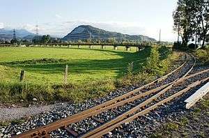
The railway bridge at Kriessern, photographed from Switzerland with Austria in the background | |||||||||||||||||||||||||||||||||||||||||||||||||||||||||||||||||||||||||||||
| Overview | |||||||||||||||||||||||||||||||||||||||||||||||||||||||||||||||||||||||||||||
| Locale |
Austria, Province of Vorarlberg Switzerland, Canton of St Gallen | ||||||||||||||||||||||||||||||||||||||||||||||||||||||||||||||||||||||||||||
| Technical | |||||||||||||||||||||||||||||||||||||||||||||||||||||||||||||||||||||||||||||
| Line length | 25 km (16 mi) | ||||||||||||||||||||||||||||||||||||||||||||||||||||||||||||||||||||||||||||
| Track gauge | 750 mm (2 ft 5 1⁄2 in) | ||||||||||||||||||||||||||||||||||||||||||||||||||||||||||||||||||||||||||||
| Electrification | 750 V DC | ||||||||||||||||||||||||||||||||||||||||||||||||||||||||||||||||||||||||||||
| |||||||||||||||||||||||||||||||||||||||||||||||||||||||||||||||||||||||||||||
The International Rhine Regulation Railway (German: Internationale Rheinregulierungsbahn) was an industrial railway situated on both banks of the Alpine Rhine river to the south of its outfall into Lake Constance. Large parts of the line have been preserved. As this stretch of the Rhine forms the international boundary between Austria and Switzerland, the railway is located in both countries.[1]
As its name suggests, the railway's original purpose was to assist in the engineering works needed to regulate the Rhine in this area. It is constructed to 750 mm gauge (2 ft 5 1⁄2 in gauge) and is partially electrified at 750 V DC using overhead lines.[2]
References
- ↑ "Strecke" [Route] (in German). Rhein-Schauen. Retrieved 2014-05-28.
- ↑ "Die Internationale Rheinregulierungs bahn". alpenbahnen.net (in German). Retrieved 2014-05-28.
External links
- Rhein-Shauen; Museum und Rheinbänle - the society that preserves the railway
| Wikimedia Commons has media related to International Rhine Regulation Railway. |
Coordinates: 47°26′52″N 9°39′41″E / 47.4478°N 9.6614°E
This article is issued from Wikipedia - version of the 6/19/2016. The text is available under the Creative Commons Attribution/Share Alike but additional terms may apply for the media files.