Insular Chile
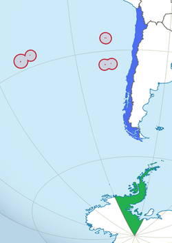
In blue: Continental Chile
In red: Insular Chile
In green: Antarctic Chile
Insular Chile, also called Las islas Esporádicas, or "the Sporadic Islands", is a scattered group of small islands and archipelagos of volcanic origin located in the South Pacific Ocean, at some distance from mainland South America, that are under the sovereignty of Chile. The Juan Fernández Islands and the Desventuradas Islands are considered Continental Insular Chile; Salas y Gómez Island and Easter Island – both geographically situated in Polynesia – form the zone known as Oceanic Insular Chile. All of insular Chile is administrated as part of the Valparaíso Region.
The Sporadic Islands are not the only Chilean insular territories; rather, these islands represent just 328 square kilometres (127 square miles), around 0.3%, of the total, the rest being 3,739 islands and 2,180 islets, the combined land area of which totals 105,561 square kilometres (40,757 square miles), nearly 14% of which is effectively under Chilean control, part of what officially distinguishes "insular Chile" from "continental Chile".[1]
Insular Chile consists of:
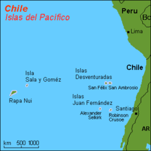
- The Juan Fernández Islands, composed of Robinson Crusoe, Alejandro Selkirk and Santa Clara islands, located 670 kilometres (420 miles) west of Valparaíso
- The Desventuradas Islands, composed of San Ambrosio and San Félix Islands, located more than 800 kilometres (500 miles) west of continental Chile, opposite the Atacama Region
- Easter Island, or Rapa Nui, 3,600 kilometres (2,200 miles) west of Caldera, with an area of 163.6 square kilometres (63.2 square miles) – the main island of the Sporadic Islands
- Salas y Gómez Island, located 3,220 kilometres (2,000 miles) west of Chañaral and 415 kilometres (258 miles) northeast of Easter Island.
Of these islands, only Easter Island and Robinson Crusoe are inhabited. Of the two, Easter Island is the farthest from the continent, part of Oceania and culturally polynesic, as is Salas y Gómez, while the Desventuradas Islands and the Juan Fernández archipelago are culturally South American.
The Sporadic islands are part of the Valparaíso Region. Easter Island and Salas y Gómez form the commune of Isla de Pascua, the only commune of Isla de Pascua Province. The Desventuradas islands and Juan Fernández belong to Valparaíso Province, and are part of the commune of Juan Fernández.
Insular Chile is located in various time zones: continental Chile, the Juan Fernández archipelago and the Desventuradas Islands are located in the UTC−3 time zone at summer timezone, and UTC−4 in winter timezone, while Easter Island and Salas y Gómez Island are both in Polynesia, (UTC−5 summer, UTC−6 winter).