Inishtrahull
| Inishtrahull Inis Trá Tholl | |
|---|---|
| Island | |
 Inishtrahull Location in Ireland | |
| Coordinates: 55°25′48″N 7°14′02″W / 55.430019°N 7.23381°WCoordinates: 55°25′48″N 7°14′02″W / 55.430019°N 7.23381°W | |
| Sovereign state | Ireland |
| Province | Ulster |
| County | County Donegal |
| Area | |
| • Total | 0.5 km2 (0.2 sq mi) |
| Elevation | 49 m (161 ft) |
| Population (2011) | |
| • Total | 0 |
| • Density | 0.0/km2 (0.0/sq mi) |
| Time zone | WET (UTC+0) |
| • Summer (DST) | IST (WEST) (UTC+1) |
| Irish Grid Reference | C439548 |

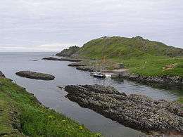
Inishtrahull (Irish: Inis Trá Tholl,[1] meaning "island of the hollow/empty beach") is the most northerly island of Ireland. It has an area of 0.34 square kilometres (0.13 sq mi)[2] and lies about 10 kilometres (6.2 mi) north-east of Malin Head, County Donegal. The most northerly landfall of Ireland, the Tor Beg rock, is another one kilometer to the north.[3] Inishtrahull is home to Ireland's northernmost lighthouse. The island had a resident community until 1929 and the lighthouse was manned until 1987. Today it is uninhabited and has been designated a protected area due to its wildlife.
Geology
The island is formed of a granitic gneiss, a type of metamorphic rock, which is known as Inishtrahull Gneiss. It is dated at 1.7 billion years old, making it Paleoproterozoic in age, and is the oldest known rock on the Irish Islands. The Inishtrahull Gneiss is considered to form part of the Rhinns complex that is also exposed on the islands of Islay and Colonsay. The Rhinns complex is correlated with the Ketilidian metamorphic belt of southern Greenland and the Svecofennian of Scandinavia.[4]
Biology
Among the alga Bonnemaisonia asparagoides, Callophyllis laciniata, Kalymenia reniformis, Sphaerococcus coronopifolius, Lomentaria articulate, Lomentaria orcadensis, Rhodymenia pseudopalmata, Plumaria plumose, Ceramium shuttleworthianum, Heterosiphonia plumose, Nitophyllum punctatum, Hypoglossum hypoglossoides, Drachiella spectabilis, Odonthalia dentate, Osmundea pinnatifida, Polysiphonia lanosa, Polysiphonia stricta, Enteromorpha intestinalis, Ulva lactuca, Fucus spiralis, Fucus serratus and Ascophyllum nodosum have been recorded.[5]
The islanders
The island is now uninhabited but had a resident community until 1929 and lighthousekeepers until 1987. The evacuation of the community from Inistrahull took place en-bloc in 1929. The matter was raised in a Dáil debate on illegal fishing in November, 1929 by the TD for the area, Deputy Carney.[6] The Deputy stated that Inishtrahull was one of the few places in the country where the population had actually increased by almost 100% from 1881 to 1901. He said that the people on the island had a school and a graveyard and earned their livelihood from the fishing industry with very small boats for inshore fishing and that they could line fish and fish with nets during the herring season. Deputy Carney said that ordinarily they were able to make a reasonable living. However, he said that because of illegal fishing by “Scotch and English trawlers and French fishing smacks” the islanders had been compelled some weeks earlier to evacuate the island, desert their homes and leave only a lighthousekeeper behind.
Responding the Minister for Fisheries, Fionán Lynch TD said that he did not agree that the people had left the island because of illegal fishing and was making enquiries as to their current circumstances. The Minister said that he “would like to feel that everything was being done to keep them from being a permanent charge on home assistance”. The Minister later sent a Principal Officer from his Department to report on their circumstances. The Minister then reported in the Dáil that “four of the [six Inistrahull] families derived their livelihood from the Irish Lights boat service to the island, in which they are still able to engage” and that there was no case state intervention. He also said that his Officer’s report indicated that the resettled Islanders were not in “poor circumstances”.[7]
| Historical population | ||||||||||||||||||||||||||||||||||||||||||||||||||||||||||||||||||||||||||||||||
|---|---|---|---|---|---|---|---|---|---|---|---|---|---|---|---|---|---|---|---|---|---|---|---|---|---|---|---|---|---|---|---|---|---|---|---|---|---|---|---|---|---|---|---|---|---|---|---|---|---|---|---|---|---|---|---|---|---|---|---|---|---|---|---|---|---|---|---|---|---|---|---|---|---|---|---|---|---|---|---|---|
|
|
| ||||||||||||||||||||||||||||||||||||||||||||||||||||||||||||||||||||||||||||||
| Source: Central Statistics Office. "CNA17: Population by Off Shore Island, Sex and Year". CSO.ie. Retrieved October 12, 2016. | ||||||||||||||||||||||||||||||||||||||||||||||||||||||||||||||||||||||||||||||||
Last sight of Ireland
Inishtrahull is home to the most northern Irish lighthouse run by the Commissioners of Irish Lights. The lighthouse was first put into operation in 1813 largely because ships of the Royal Navy had begun to use Lough Foyle. Today its light flashes every 30 seconds.[8] The ruins of the old lighthouse as well as a new (1956) lighthouse can be found on the island. Automation of the lighthouse was completed in March 1987 and the last three Lighthousekeepers left the station on 30 April 1987.[8] Over the centuries, Ireland has been the source of millions of emigrants bound for the “New World” across the Atlantic. For many of those emigrants, especially those who departed from Derry, Inistrahull and its lighthouse had a special significance. As one emigrant recalled:
“[The voyage] was quite pleasant for a while. There was, however, one milestone to pass, Inishtrahull lighthouse off the coast of Donegal was the last glimpse emigrants would have of Ireland [and] everyone stayed on deck until it disappeared. They stayed on when they couldn’t see it anymore because the more keen sighted kept saying it is still there. When the sharp eyed ones admitted the light had faded all frivolity ceased, handkerchiefs came out and there was much sniffing as we drifted to our staterooms. The next stop was New York”
Attractions
Inishtrahull is well known for its wildlife and is designated a Special Area of Conservation and a Special Protection Area by the National Parks and Wildlife Service.[9]
The island's geographical location and lighthouse attract many unusual birds, as well as a population of grey seals. The island and its adjacent 90 metre depth tidal sound attract basking sharks and cetaceans in large numbers during the summer months. Many scuba-divers use the Islands Port Mór as a lunch spot while out surveying the hundreds of wrecks off its shores. Access to the island is limited by the dangerous tides and currents around Malin Head and the island itself. There are landing restrictions enforced by the National Parks and Wildlife Service and the Commissioners of Irish Lights (present owners of the Island). Particular care is requested by visitors during the breeding bird period of May-July. As of 2015 there are two Geocaches on the island.

References
- ↑ Placenames Database of Ireland: Inishtrahull/Inis Trá Tholl
- ↑ Per Ivar Haug, Gazetteer of Ireland, Trondheim University 2007.
- ↑ "Ireland - Geographical facts and figures". Travel through the Ireland story... Retrieved 2007-09-15.
- ↑ Muir, R.J.; Fitches W.R.; Maltman A.J. (1994). "The Rhinns Complex: Proterozoic basement on Islay and Colonsay, Inner Hebrides, Scotland, and on Inishtrahull, NW Ireland". Transactions of the Royal Society of Edinburgh: Earth Sciences. Royal Society of Edinburgh. 85 (1): 77–90. doi:10.1017/s0263593300006313. Retrieved 15 September 2012.
- ↑ Morton, O. 2003. The marine macroalgae of County Donegal, Ireland. Bulletin Irish Biogeographic Society 27: 3 - 164
- ↑ 14 November 1929 Dáil Debate
- ↑ 10 April 1930 Dáil Debate
- 1 2 Irish Lights Commissioners
- ↑ Inishtrahull SAC, npws.ie; accessed 7 November 2016.
- The book of Inishtrahull by Sean Beattie
- Local Island history collection by Des Mills
- Irish national parks and wildlife service
- Irish lights
- Wildlife of Ireland (Inistrahull information section
Places in County Donegal | ||
|---|---|---|
| Towns |  | |
| Villages |
| |
| Townlands | ||
| Islands | ||
| Other regions | ||
| ||