Indian River, Michigan
| Indian River, Michigan | |
|---|---|
| Census-designated place & Unincorporated community | |
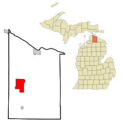 Location of Indian River, Michigan | |
| Coordinates: 45°24′45″N 84°36′45″W / 45.41250°N 84.61250°WCoordinates: 45°24′45″N 84°36′45″W / 45.41250°N 84.61250°W | |
| Country | United States |
| State | Michigan |
| County | Cheboygan |
| Area | |
| • Total | 20.2 sq mi (52.4 km2) |
| • Land | 12.9 sq mi (33.3 km2) |
| • Water | 7.4 sq mi (19.1 km2) |
| Elevation | 610 ft (186 m) |
| Population (2010) | |
| • Total | 1,959 |
| • Density | 152/sq mi (58.8/km2) |
| Time zone | Eastern (EST) (UTC-5) |
| • Summer (DST) | EDT (UTC-4) |
| ZIP code |
49749 (Indian River), 49799 (Wolverine) |
| Area code(s) | 231 |
| FIPS code | 26-40480[1] |
| GNIS feature ID | 0629015[2] |
Indian River is an unincorporated community in Cheboygan County in the U.S. state of Michigan. It is a census-designated place (CDP) for statistical purposes and is not legally recognized as a municipality. The population was 1,959 at the 2010 census.[3]
Geography
Because it is not an incorporated municipality, the boundaries were defined by the U.S. Census Bureau in consultation with local organizations and officials. However, the area included within the CDP may not exactly correspond with the area which locals recognize by that name. The CDP occupies the eastern half of Tuscarora Township.[4] The Indian River ZIP code 49749 includes most of the CDP as well additional areas of both Tuscarora and Koehler townships and portions of Burt Township, Mullett Township, and Aloha Township to the north and Mentor Township and Ellis Township to the south.[5] The southeast portion of the CDP is served by the Wolverine ZIP code 49799.[6]
Indian River is situated at the point where the Sturgeon River flows into Burt Lake and where the Indian River flows out of Burt Lake into Mullett Lake. I-75 passes though the area with two interchanges nearby. Mackinaw City and the Mackinac Bridge are about 25 miles (40 km) to the north, and Gaylord is 28 miles (45 km) to the south. Cheboygan is about 21 miles (34 km) to the northeast on M-27. M-68 connects with US 31 at Alanson, 11 miles (18 km) to the west and with M-33 about 9 miles (14 km) to the east. The Indian River provides a navigable channel between Burt and Mullett lakes.
Burt Lake State Park is included within the CDP. It draws numerous tourists each year. The local economy is partially based on summer travelers, who take part in the watersports, camping facilities, and other attractions around Indian River. The North Central State Trail goes through the town. The National Shrine of the Cross in the Woods, an open-air sanctuary, is located in Indian River and dedicated to Kateri Tekakwitha, the first Native American saint.
According to the United States Census Bureau, the CDP has a total area of 20.2 square miles (52.4 km2), of which 12.9 square miles (33.3 km2) is land and 7.4 square miles (19.1 km2), or 36.38%, is water.[3]
Demographics
As of the census[1] of 2000, there were 2,008 people, 929 households, and 614 families residing in the CDP. The population density was 156.4 per square mile (60.4/km²). There were 1,586 housing units at an average density of 123.5 per square mile (47.7/km²). The racial makeup of the CDP was 97.16% White, 0.05% Black or African American, 0.90% Native American, 0.10% Asian, 0.20% from other races, and 1.59% from two or more races. Hispanic or Latino of any race were 1.44% of the population.
There were 929 households out of which 23.0% had children under the age of 18 living with them, 56.6% were married couples living together, 7.4% had a female householder with no husband present, and 33.9% were non-families. 29.9% of all households were made up of individuals and 14.3% had someone living alone who was 65 years of age or older. The average household size was 2.16 and the average family size was 2.65.
In the CDP the population was spread out with 19.0% under the age of 18, 4.9% from 18 to 24, 22.5% from 25 to 44, 29.5% from 45 to 64, and 24.1% who were 65 years of age or older. The median age was 47 years. For every 100 females there were 93.8 males. For every 100 females age 18 and over, there were 90.6 males.
The median income for a household in the CDP was $34,854, and the median income for a family was $41,667. Males had a median income of $40,139 versus $21,042 for females. The per capita income for the CDP was $20,191. About 5.5% of families and 7.1% of the population were below the poverty line, including 8.7% of those under age 18 and 5.3% of those age 65 or over.
References
- 1 2 "American FactFinder". United States Census Bureau. Archived from the original on September 11, 2013. Retrieved 2008-01-31.
- ↑ U.S. Geological Survey Geographic Names Information System: Indian River, Michigan
- 1 2 "Geographic Identifiers: 2010 Demographic Profile Data (G001): Indian River CDP, Michigan". U.S. Census Bureau, American Factfinder. Retrieved September 19, 2014.
- ↑ "2013 ACS Vintage TIGERweb". U.S. Census Bureau. Retrieved September 19, 2014.
- ↑ 49749 5-Digit ZCTA, 497 3-Digit ZCTA - Reference Map - American FactFinder, U.S. Census Bureau, 2000 census
- ↑ 49799 5-Digit ZCTA, 497 3-Digit ZCTA - Reference Map - American FactFinder, U.S. Census Bureau, 2000 census
External links
- Indian River Chamber of Commerce
- Indian River site, provided by the Straitsland Resorter
- Straitsland Resorter, Indian River newspaper
Municipalities and communities of Cheboygan County, Michigan, United States | ||
|---|---|---|
| City | 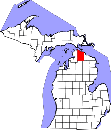 | |
| Villages | ||
| Townships | ||
| CDP | ||
| Other unincorporated communities | ||
| Footnotes | ‡This populated place also has portions in an adjacent county or counties | |