Imbabura Province
This article is about the Imbabura province. For the Imbabura volcano, see Imbabura Volcano.
| Imbabura | |||
|---|---|---|---|
| Province | |||
| Province of Imbabura | |||
|
Mount Imbabura from south-east. | |||
| |||
 Imbabura Province in Ecuador | |||
 Cantons of Imbabura Province | |||
| Country |
| ||
| Capital | Ibarra | ||
| Government | |||
| • Provincial Prefect | Diego García | ||
| Area | |||
| • Total | 4,587.51 km2 (1,771.25 sq mi) | ||
| Population (2010 census) | |||
| • Total | 398,244 | ||
| • Density | 87/km2 (220/sq mi) | ||
| Time zone | ECT | ||
| Vehicle registration | I | ||


Imbabura is a province in Ecuador. The capital is Ibarra. The people of the province speak Spanish and the Imbaburan Quechua language.
Imbabura Volcano is located in the province. Best reached from the town of La Esperanza, the 4,609-meter-high mountain can be climbed in a single day.
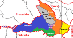
Cantons
The province is divided into six cantons. The following table lists each with its population at the 2001 census, its area in square kilometres (km²), and the name of the cantonal seat or capital.[1]
| Canton | Pop. (2001) | Area (km²) | Seat/Capital |
|---|---|---|---|
| Antonio Ante | 36,053 | 81 | Atuntaqui |
| Cotacachi | 37,215 | 1,726 | Cotacachi |
| Ibarra | 153,256 | 1,093 | Ibarra |
| Otavalo | 90,188 | 500 | Otavalo |
| Pimampiro | 12,951 | 437 | Pimampiro |
| San Miguel de Urcuquí | 14,381 | 779 | Urcuquí |
Demographics
Ethnic groups as of the Ecuadorian census of 2010:[2]
- Mestizo 65.7%
- Indigenous 25.8%
- Afro-Ecuadorian 5.4%
- White 2.7%
- Montubio 0.3%
- Other 0.1%
See also
References
- ↑ Cantons of Ecuador. Statoids.com. Retrieved 4 November 2009.
- ↑

Imbabura Volcano photographed in black and white.
- "Volcán Imbabura" (in Spanish). Archived from the original on 2006-08-22.
Coordinates: 0°21′N 78°08′W / 0.350°N 78.133°W
This article is issued from Wikipedia - version of the 11/12/2016. The text is available under the Creative Commons Attribution/Share Alike but additional terms may apply for the media files.