Lake Ilopango
| Lake Ilopango | |
|---|---|
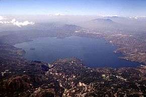 Lake Ilopango seen from the east, San Salvador city and San Salvador Volcano can be seen just behind the lake looming in the haze | |
| Highest point | |
| Elevation | 450 m (1,480 ft) |
| Coordinates | 13°40′N 89°03′W / 13.67°N 89.05°W |
| Geography | |
| Location | El Salvador |
| Geology | |
| Mountain type | Caldera |
| Last eruption | 1879 to 1880 |
| Lake Ilopango | |
|---|---|
| Location | Central El Salvador |
| Coordinates | 13°40′N 89°03′W / 13.67°N 89.05°WCoordinates: 13°40′N 89°03′W / 13.67°N 89.05°W |
| Type | crater lake |
| Basin countries | El Salvador |
| Max. length | 11 km (6.8 mi) |
| Max. width | 8 km (5.0 mi) |
| Surface area | 72 km2 (28 sq mi) |
| Max. depth | 230 m (750 ft) |
| Surface elevation | 440 m (1,440 ft) |
| Islands | Islas Quemadas |
Lake Ilopango is a crater lake which fills a scenic 8 by 11 km (72 km2 or 28 sq mi) volcanic caldera in central El Salvador, on the borders of the San Salvador, La Paz, and Cuscatlán departments.[1] The caldera, which contains the second largest lake in the country and is immediately east of the capital city, San Salvador, has a scalloped 100 m (330 ft) to 500 m (1,600 ft) high rim.[2] Any surplus drains via the Jiboa River to the Pacific Ocean. The lake is known for being a possible source for the extreme weather events of 535–536. The military airbase, Ilopango International Airport, has annual airshows where international pilots from all over the world fly over San Salvador City and Ilopango lake.
Eruptive history
Four major dacitic - rhyolitic eruptions occurred during the late Pleistocene and Holocene, producing pyroclastic flows and tephra that blanketed much of the country.[2]
The caldera collapsed most recently[2] sometime between 410 and 535 AD (based on radiocarbon dating of plant life directly related to the eruption),[3] which produced widespread pyroclastic flows and devastated Mayan cities. The eruption produced about 25 km3 (6.0 cu mi) of tephra (20 times as much as the 1980 eruption of Mount St. Helens), thus rating a 6 on the (VEI) Volcanic Explosivity Index. The "ash-cloud fallout [..] blanketed an area of at least 10,000 square kilometres waist-deep in pumice and ash", which would have stopped all agricultural endeavor in the area for decades.[4]
Later eruptions formed several lava domes within the lake and near its shore. The only historical eruption, which occurred from December 31, 1879, up to March 26, 1880, produced a lava dome and had a VEI of 3.[2] The lava dome reached the surface of the lake, forming the islets known as Islas Quemadas.[5][6]
See also
Gallery
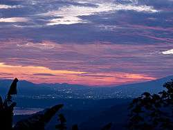 Lake Ilopango, seen in the evening from Cojutepeque. The lights of Ilopango and San Salvador can be seen in the distance.
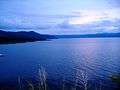 Lake Ilopango.
 Lake Ilopango, as seen from the Panamerican Highway
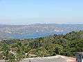 As seen from Santiago Texacuangos
 The community of Apulo near Lake Ilopango, 1990 (photographed by Linda Hess Miller)
References
- ↑ "Lake Ilopango". Encyclopædia Britannica. Retrieved 13 July 2012.
- 1 2 3 4 "Ilopango: Eruptive History". Global Volcanism Program. Smithsonian Institution.
- ↑ Dull, Robert A.; Southon, John R.; Sheets, Payson (2001). "Volcanism, Ecology and Culture: A Reassessment of the Volcan Ilopango Tbj eruption in the Southern Maya Realm". Latin American Antiquity. Latin American Antiquity, Vol. 12, No. 1. 12 (1): 25–44. doi:10.2307/971755. JSTOR 971755., esp. p.27.
- ↑ Clive Oppenheimer (2011). Eruptions that shook the world. Cambridge University Press. ISBN 978-0-521-64112-8.
- ↑ Golombek, Matthew P.; Carr, Michael J. (1978). "Tidal triggering of seismic and volcanic phenomena during the 1879–1880 eruption of Islas Quemadas volcano in El Salvador, Central America". Journal of Volcanology and Geothermal Research. 3 (3–4): 299–307. Bibcode:1978JVGR....3..299G. doi:10.1016/0377-0273(78)90040-9.
- ↑ "Historia y cultura de Ilopango". Elsalvadorenelmundo.com. Retrieved 2014-02-02.
External links
| Wikimedia Commons has media related to Ilopango Caldera. |