Ille-sur-Têt
| Ille-sur-Têt | ||
|---|---|---|
|
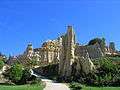
The town hall in Ille-sur-Têt | ||
| ||
 Ille-sur-Têt | ||
|
Location within Occitanie region  Ille-sur-Têt | ||
| Coordinates: 42°40′18″N 2°37′17″E / 42.6717°N 2.6214°ECoordinates: 42°40′18″N 2°37′17″E / 42.6717°N 2.6214°E | ||
| Country | France | |
| Region | Occitanie | |
| Department | Pyrénées-Orientales | |
| Arrondissement | Prades | |
| Canton | Vinça | |
| Intercommunality | Roussillon Conflent | |
| Government | ||
| • Mayor (2009–2014) | Willy Burghoffer | |
| Area1 | 31.67 km2 (12.23 sq mi) | |
| Population (2007)2 | 5,244 | |
| • Density | 170/km2 (430/sq mi) | |
| Time zone | CET (UTC+1) | |
| • Summer (DST) | CEST (UTC+2) | |
| INSEE/Postal code | 66088 / 66130 | |
| Elevation |
110–446 m (361–1,463 ft) (avg. 160 m or 520 ft) | |
|
1 French Land Register data, which excludes lakes, ponds, glaciers > 1 km² (0.386 sq mi or 247 acres) and river estuaries. 2 Population without double counting: residents of multiple communes (e.g., students and military personnel) only counted once. | ||
.jpg)

Ille-sur-Têt (Catalan: Illa or Illa de Tet) is a commune in the Pyrénées-Orientales département in southern France.
Its inhabitants are called Illois.
Geography
The commune is situated in the Ribéral region along the route nationale 116 and is crossed by the Têt River (in the north), as well as by its tributary, the Boulès (in the south). It is one of the gateways to the Fenouillèdes region (towards Montalba-le-Château or Bélesta).
Ille-sur-Têt is located in the canton of Vinça and in the arrondissement of Prades.
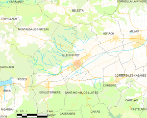
Map of Ille-sur-Têt and its surrounding communes
Population
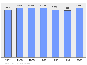
Population 1962-2008
Sites of interest
- Saint-Étienne Church
- Hospice d'Ille-sur-Tet (Hospici d'Illa in Catalan)
- The geological site of the Orgues d'Ille-sur-Têt
Notable people
- Jean Bardou (1799-1852), industrialist, born in Ille-sur-Têt.
- Charles Dupuy (1851-1923), died in Ille-sur-Têt in 1923, President of the Council of Ministers under Presidents Sadi Carnot, Jean Casimir-Perier, Félix Faure and Émile Loubet.
- Joseph-Sébastien Pons (1886-1962), poet, born and dead in Ille-sur-Têt.
- Xavier de Gaulle (1887-1955), civil engineer (mines), Second World War résistant. Arrested but released as a veteran, the Vichy regime sent him to Ille-sur-Têt as a tax inspector but he remained under police surveillance. He fled to Switzerland where in 1944 he was made Consul Général de France, a post he held until 1953.
- Pierre Fouché (1891-1967), died in Ille-sur-Têt, linguist.
- Jean Galia (1905-1949), born in Ille-sur-Têt, rugby union and rugby league player.
- Louis Amade (1915–1992), born in Ille-sur-Têt, writer, songwriter for Gilbert Bécaud and Édith Piaf among others.
- Paul Blanc (1937-), former Senator for Pyrénées-Orientales and mayor of Sournia, born in Ille-sur-Têt.
- Paul Loridant (1948-), born in Ille-sur-Têt, Senator for Essonne .
In fiction
Prosper Mérimée's short story La Vénus d'Ille takes place in Ille-sur-Têt.
See also
References
External links
| Wikimedia Commons has media related to Ille-sur-Têt. |


This article is issued from Wikipedia - version of the 2/10/2016. The text is available under the Creative Commons Attribution/Share Alike but additional terms may apply for the media files.