Ilchester


Coordinates: 51°00′04″N 2°40′57″W / 51.0011°N 2.6825°W
Ilchester is a village and civil parish, situated on the River Yeo or Ivel, five miles north of Yeovil, in the English county of Somerset. Originally a Roman town, and later a market town, Ilchester has a rich medieval history and was a notable settlement in the county; around the 12th and 13th centuries it was effectively the county town. It had, however, declined in size and importance by the beginning of the 18th century,[2] and the last markets were held in 1833.[3] In 1889 the historic corporation that had governed the town (the Bailiff and Burgesses) was dissolved.[4]
Ilchester is alternatively called Ivelchester (after the River Ivel) and the electoral ward of South Somerset District Council is named Ivelchester.[5]
Geography
The parish, which includes the former village of Sock Dennis, or Stock-Dennis, and the old parish of Northover, has a population of 2,153.[1] Sock Dennis lies on the Monarch's Way long-distance footpath.
The A303 road once passed through the village but now runs via a dual carriageway bypass just to the west.[6]
The village of Yeovilton lies 1.5 miles (2.4 km) to th east of Ilchester.[6] RNAS Yeovilton continues to be a notable Royal Naval Air Station.
History
Roman times
In the Roman period, the place was named Lindinis and was the site of a fort and then a town on the Fosse Way. Finds from a large 4th-century cemetery at Northover House suggest Christian worship.[7] It eventually served as one of two regional capitals for the Durotriges tribe.[8]
Medieval times
The place-name 'Ilchester' is first attested in the Domesday Book of 1086, where it appears as Givelcestre. The name means 'Roman fort on the River Yeo'.[9]
There is evidence of continuous occupation of Ilchester despite the Roman withdrawal from Britain around 410.[10] Ilchester has been associated with the Cair Pensa vel Coyt [11] listed among the 28 cities of Britain by the History of the Britons, on the basis that it should be read as an Old Welsh form of 'Penselwood'[12] (coit being Welsh for "forest"), although others view it as three separate words: Pensa or Coyt. Bishop Ussher believed the listing referred to Exeter instead.[13]
Around the year 1000, there was a mint at Ilchester, which was moved to South Cadbury following attacks by the Danes,[8] and prior to the Siege of Ilchester in 1088.
The parish of Ilchester was part of the Tintinhull Hundred.[14]

Ilchester Friary was founded between 1221 and 1260 as a Dominican monastery. The buildings were restored in the 13th and 14th centuries until the site occupied a 1.6 hectares (4.0 acres) site, and by the 15th century it extended beyond the town walls.[15] It is believed to be the birthplace of Roger Bacon, possibly in 1213 or 1214.[16] It was dissolved in 1538, as part of the dissolution of the monasteries,[15] but the buildings continued to be used, as a silk mill and relief prison, particularly for Quakers,[17] until it was finally demolished in the early 19th century.[15]
Ilchester Nunnery was founded around 1217–1220 originally as White Hall Hospital (Latin: Alba Aula, French: Blanche Halle/Blanche Salle) and, by 1281, had been converted into an Augustinian nunnery. The original White Hall hospital had been created after the gift of a house and other property by William "The Dane" (Norman-French: Le Deneis etc., Latinised to Dacus {not in the least bit related to Dacia}, modernised to "Dennis") of Sock Dennis.[18] From a branch of this family was possibly descended the influential Denys family of Devon, (arms: three Danish battle axes) seated at Orleigh, near Buckland Brewer, Devon, from the 12th. to 17th. centuries[19] In the early 14th century concerns were raised about the management of the nunnery and the poverty of the nuns.[20] The building was expanded in 1370. The nunnery was dissolved in 1463 and the chapel become a free chapel,[21] which itself was dissolved in 1548.[22] A ruined building still existed in 1791, but the stone was then used to build the nearby Castle Farm.[22]
Ilchester was a base for Henry III of England for a short period in 1250.[8]
During the 12th century it was the county town of Somerset.[8] The town has a 13th-century mace with three kings and an angel on it, which is the oldest staff of office in England.[23] It can be seen at Ilchester Museum, which is located at the Town Hall.[3]
In July 1645 during the English Civil War, Ilchester was the scene of several skirmishes between Royalist and Parliamentary forces fighting for control of the bridges over the River Parrett and River Yeo before the Battle of Langport.[24]
Georgian times
In 1795 work began on the Ivelchester and Langport Navigation, a canal linking Ilchester with Langport, but the scheme was soon bankrupted.
20th century
In 1962 the Ilchester Cheese Company was formed.[25]
Rotten borough
From 1621 to 1832, Ilchester was a Parliamentary constituency and a notorious rotten borough.
Ilchester was the parliamentary seat of Sir William Manners (later Lord Huntingtower) in 1802, 1812 and 1818; however, it is said that he maintained his position by demolishing the houses of his opponents and putting them in the workhouse which meant they were not able to vote. He was defeated by Lord Darlington who built houses for his supporters and thereby became the Member of Parliament.[8]
Sock Dennis
In the Domesday Book, the village of Sock Dennis was in the possession of Robert, Count of Mortain. From the mid-13th century it was described as a manor, but by the end of the 18th century it was "an obliterated place". The place name derives from "Sock", probably an area of marsh or streams, and the family name of the successors of William the Dane, a 12th-century owner.[26]
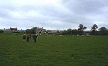
There is an area of well-preserved ridge and furrow earthworks over three fields to the east of Sock Dennis.[27]
There was a church in the village of Sock Dennis in 1286. It was a daughter church of Yeovil. In 1297 the church was worth £7 15s. The church had disappeared by 1575. A doorway, probably of the early 16th century, and perhaps forming part of the fabric of the church, is incorporated in one of the buildings of Sock Dennis farm,[28] which is all that now remains of the village.
In 1861 Sock Dennis's total population was 26. In 1901 it was 22. By 1951 the population was 23.
After the church in Sock Dennis was destroyed, and the place was almost depopulated, it lost its parochial rights.[29] In 1884 it was reduced, in order to enlarge the parish of Tintinhull. In 1957 the parish was abolished and 401 acres (1.62 km2) with a population of 11 people transferred to Ilchester parish and 287 acres (1.16 km2) and 12 people transferred to Tintinhull parish.[30]
Governance
The parish council has responsibility for local issues, including setting an annual precept (local rate) to cover the council’s operating costs and producing annual accounts for public scrutiny. The parish council evaluates local planning applications and works with the local police, district council officers, and neighbourhood watch groups on matters of crime, security, and traffic. The parish council's role also includes initiating projects for the maintenance and repair of parish facilities, as well as consulting with the district council on the maintenance, repair, and improvement of highways, drainage, footpaths, public transport, and street cleaning. Conservation matters (including trees and listed buildings) and environmental issues are also the responsibility of the council.
The parish falls within the non-metropolitan district of South Somerset, which was formed on 1 April 1974 under the Local Government Act 1972, having previously been part of Yeovil Rural District.[31] The district council is responsible for local planning and building control, local roads, council housing, environmental health, markets and fairs, refuse collection and recycling, cemeteries and crematoria, leisure services, parks, and tourism.

Somerset County Council is responsible for running the largest and most expensive local services such as education, social services, libraries, main roads, public transport, policing and fire services, trading standards, waste disposal and strategic planning.
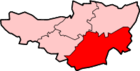
The parish is in the 'Ivelchester' electoral ward. Ilchester is the most populous area of the ward but this stretches south east to Mudford. The total population of this ward taken at the 2011 census was 4,319.[32]
It is also part of the Yeovil county constituency represented in the House of Commons of the Parliament of the United Kingdom. It elects one Member of Parliament (MP) by the first past the post system of election, and part of the South West England constituency of the European Parliament which elects seven MEPs using the d'Hondt method of party-list proportional representation.
Ilchester Town Trust
Separate to the parish council, the Ilchester Town Trust repairs and manages the Town Hall, as well as providing for charitable purposes for the inhabitants of Ilchester. As well as the Town Hall, the Trust has ownership of the Roman cemetery in Northover and the Ilchester sportsfield. The Trust was established in 1889, upon the dissolution of the historic corporation that had governed the town (the Bailiff and Burgesses). At the Town Hall, the Trust runs the Ilchester Museum.[4]
Religious sites

Ilchester had at least eight churches in medieval times of which two remain. The church of St Mary Major dates from the 13th century and is a Grade II* listed building,[33] as is the Church of St Andrew which is slightly more recent,[34] although it may stand on the site of an earlier Roman building and associated cemetery.[35] St Andrew's is in the care of the Churches Conservation Trust.[36]
Education
Ilchester Community Primary School consists of a Junior school and an Infant school, which cover key stage 1 and key stage 2 of the national curriculum. Both parts of the school are separate, each having a deputy head of year. The school has 295 pupils enrolled.[37] The school was awarded Healthy school status in the summer of 2007.[38] Ilchester has a few Pre-schools and a Nursery. Heron Pre-School provision was rated as good by OFSTED in 2010.[39] St Mary's Pre-School, Ilchester has been in existence for around 40 years. It is located in the heart of the village, in the Church Rooms next to St Mary Major, its most recent Ofsted was in 2012 where it was rated as GOOD, particularly in safeguarding and relationships with parents http://www.ofsted.gov.uk/inspection-reports/find-inspection-report/provider/CARE/143117
Notable people from Ilchester
- Richard of Ilchester, also called Richard of Toclyve or Richard of Toclive (d. December 22, 1188) was a medieval English statesman and prelate.
- Roger Bacon, who was a notable medieval scientist, is said to have been born in or near Ilchester.[23] He was known as "Doctor Mirabilis" and was one of the first to insist on the use of experimentation to back theory.
- William Arnold one of the founding settlers of the Colony of Rhode Island and Providence Plantations, one of the thirteen original proprietors of Providence, and was one of the twelve founding members of the first Baptist Church in America.[40]
References
- 1 2 "Statistics for Wards, LSOAs and Parishes — SUMMARY Profiles" (Excel). Somerset Intelligence. Retrieved 4 January 2014.
- ↑ Ilchester Parish Council A Brief History
- 1 2 Local Histories Ilchester
- 1 2 Ilchester Parish Council - Ilchester Town Trust
- ↑ South Somerset District Council Ivelchester ward profile (2011 census)
- 1 2 Ordnance Survey mapping
- ↑ Webster, Chris; Mayberry, Tom (2007). "The Roman Period". The archaeology of Somerset. Wellington: Somerset Books. p. 56. ISBN 978-0-86183-437-2.
- 1 2 3 4 5 Dunning, Robert (1983). A History of Somerset. Chichester: Phillimore & Co. ISBN 0-85033-461-6.
- ↑ Eilert Ekwall, The Concise Oxford Dictionary of English Place-names, p.262.
- ↑ Havinden, Michael. The Somerset Landscape. The making of the English landscape. London: Hodder and Stoughton. p. 73. ISBN 0-340-20116-9.
- ↑ Nennius (attrib.). Theodor Mommsen (ed.). Historia Brittonum, VI. Composed after AD 830. (Latin) Hosted at Latin Wikisource.
- ↑ Ford, David Nash. "The 28 Cities of Britain" at Britannia. 2000.
- ↑ Newman, John Henry & al. Lives of the English Saints: St. German, Bishop of Auxerre, Ch. X: "Britain in 429, A. D.", p. 92. James Toovey (London), 1844.
- ↑ "Somerset Hundreds". GENUKI. Retrieved 22 October 2011.
- 1 2 3 "Dominican friary, West Street, Ilchester". Somerset Historic Environment Record. Somerset County Council. Retrieved 9 January 2010.
- ↑ James, R.R. (1928). "THE FATHER OF BRITISH OPTICS: ROGER BACON, c. 1214-1294". British Journal of Ophthalmology. 12 (1): 1–14. doi:10.1136/bjo.12.1.1. PMC 511940
 . PMID 18168687.
 - ↑ Dunning, Robert W. "Ilchester". A History of the County of Somerset: Volume 3. British History Online. Retrieved 9 January 2010.
- ↑ Page, William (1911). "Hospitals: Ilchester and Langport',". A History of the County of Somerset: Volume 2. British History Online. Retrieved 9 January 2010.
- ↑ The Battle Abbey Roll by The Duchess of Cleveland, Vol.1, "Denise"
- ↑ Power, Eileen (1988). Medieval English Nunneries, c. 1275 to 1535. Biblo & Tannen Booksellers & Publishers Incorporat. p. 233. ISBN 978-0-8196-0140-7.
- ↑ "Chapel, Whitehall hospital and nunnery, High Street, Ilchester". Somerset Historic Environment Record. Somerset County Council. Retrieved 9 January 2010.
- 1 2 "Augustinian nunnery, High Street, Ilchester". Somerset Historic Environment Record. Somerset County Council. Retrieved 9 January 2010.
- 1 2 Leete-Hodge, Lornie (1985). Curiosities of Somerset. Bodmin: Bossiney Books. p. 73. ISBN 0-906456-98-3.
- ↑ Barratt, John (2005). The civil war in the south west. Barnsley: Pen & Sword Military. p. 116. ISBN 1-84415-146-8.
- ↑ "The story". Ilchester Cheese Company. Retrieved 2010-09-28.
- ↑ "Deserted medieval village, Sock Dennis Farm, Sock Dennis". Somerset Historic Environment Record. Retrieved 2008-01-06.
- ↑ "Ridge and furrow at Sock Dennis, Ilchester". Somerset Historic Environment Record. Retrieved 2008-01-06.
- ↑ "St John the Baptist church, Sock Dennis Farm". Somerset Historic Environment Record. Retrieved 2008-01-06.
- ↑ "Stock-Dennis". British History Online. Retrieved 2008-01-06.
- ↑ "Sock Dennis". A vision of Britain through time. Retrieved 2008-01-06.
- ↑ "Yeovil RD". A vision of Britain Through Time. University of Portsmouth. Retrieved 4 January 2014.
- ↑ "Ivelchester ward 2011. Retrieved 4 March 2015".
- ↑ "church of St Mary Major". Images of England. Retrieved 2006-11-11.
- ↑ "church of St Andrew". Images of England. Retrieved 2006-11-11.
- ↑ Havinden, Michael. The Somerset Landscape. The making of the English landscape. London: Hodder and Stoughton. p. 69. ISBN 0-340-20116-9.
- ↑ "St Andrew, Northover". Churches Conservation Trust. Retrieved 2010-01-14.
- ↑ "Ilchester Community School". Ofsted. Retrieved 5 March 2011.
- ↑ "Achievements". Ilchester School. Retrieved 2009-04-01.
- ↑ "Heron Pre-School Inspection report for early years provision". Oftsed. Retrieved 16 June 2011.
- ↑ Hubbard, Edwin (October 1879). "Early Records of the Arnold Family". New England Historical and Genealogical Register. New England Historic Genealogical Society. 33: 427–432. ISBN 0-7884-0293-5.
External links
| Wikimedia Commons has media related to Ilchester. |
- Ilchester Parish Council
- The Somerset Urban Archaeological Survey: Ilchester, by Miranda Richardson
- Ilchester at DMOZ