Ihme
This article is about river in Germany. For global health institute, see Institute for Health Metrics and Evaluation.
 | |
| The Ihme near the southern city boundary of Hanover | |
| Location | Hanover Region, Lower Saxony, |
|---|---|
| Length | 16 km (10 mi) |
| Source | near Wennigsen from the Wennigser Mühlbach and Bredenbecker Beeke |
| Source height | 70 m above sea level (NN) |
| Mouth | In Hanover into the Leine 52°22′38″N 9°42′45″E / 52.3771°N 9.71245°E |
| Mouth height | 50 m above sea level (NN) |
| Descent | 20 m |
| Basin | Weser < Aller < Leine |
| Catchment | 110 km2 (42 sq mi) |
| Right tributaries | Seniebach |
| Left tributaries | Hirtenbach, Schneller Graben |
| Cities | Hanover |
| Small towns | Ronnenberg, Wennigsen (Deister) |
| Population in catchment | 500.000 |
| Navigable | Schneller Graben to Leine |
 | |
| The confluence of the Ihme with the Leine (Leine from the right) | |
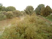 | |
| Ihme in a flood ditch in Hanover, taking floodwater to the Leine. Right: flooded cycle path | |
The Ihme is a 16-kilometre (10 mi) long river in Lower Saxony. It gives its name to the locality Ihme Roloven and is a left tributary of the Leine. Its source is in the village Evestorf. After about 6 kilometres (4 mi), the Ihme reaches the city of Hanover, where it flows into the Leine. In order to protect the city center of Hanover from flooding, much of the water of the Leine is rerouted by a ditch into the Ihme. A bridge over the Ihme is named in memory of Benno Ohnesorg.
Coordinates: 52°23′N 9°43′E / 52.383°N 9.717°E
| Wikimedia Commons has media related to Ihme. |
This article is issued from Wikipedia - version of the 5/22/2016. The text is available under the Creative Commons Attribution/Share Alike but additional terms may apply for the media files.