Iceberg Lake
| Iceberg Lake | |
|---|---|
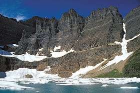 Iceberg Lake below Iceberg Peak | |
| Location | Glacier National Park, Glacier County, Montana, US |
| Coordinates | 48°48′44″N 113°44′59″W / 48.81222°N 113.74972°WCoordinates: 48°48′44″N 113°44′59″W / 48.81222°N 113.74972°W[1] |
| Type | Natural |
| Primary outflows | Iceberg Creek |
| Basin countries | United States |
| Max. length | .50 miles (0.80 km) |
| Max. width | .35 miles (0.56 km) |
| Surface elevation | 6,094 ft (1,857 m) |
Iceberg Lake is located in Glacier National Park, in the U. S. state of Montana. Mount Wilbur is south and Iceberg Peak is west of Iceberg Lake. Iceberg Peak towers more than 3,000 feet (910 m) above the lake.[2] A popular day hike destination, Iceberg Lake is a 4.8 miles (7.7 km) hike from the Swiftcurrent Auto Camp Historic District.[3]
See also
List of lakes in Glacier County, Montana
References
- ↑ "Iceberg Lake". Geographic Names Information System. United States Geological Survey. Retrieved 2011-01-25.
- ↑ "Many Glacier, MT" (Map (USGS Quad)). TopoQuest. Retrieved 2011-01-25.
- ↑ "Day Hikes" (pdf). Plan Your Visit. National Park Service. Retrieved 2011-01-25.
This article is issued from Wikipedia - version of the 10/4/2014. The text is available under the Creative Commons Attribution/Share Alike but additional terms may apply for the media files.