Ice Age Trail
| Ice Age Trail | |
|---|---|
|
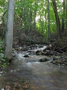
The Ice Age Trail's Wood Lake segment in Taylor County | |
| Length |
600 miles (970 km) completed 1,200 miles (1,900 km) planned |
| Location | Wisconsin, United States |
| Designation | National Scenic Trail |
| Trailheads |
Potawatomi State Park, Door County, Wisconsin Interstate State Park near St. Croix Falls, Wisconsin |
| Use | Hiking, Snowshoeing |
| Elevation | |
| Highest point | Lookout Mountain, Lincoln County, 1,920 ft (590 m) |
| Lowest point | Lakeshore of Lake Michigan, 580 ft (180 m) |
| Hiking details | |
| Trail difficulty | Easy to moderate, varies by location |
| Months | Year-round, subject to weather conditions |
| Sights | Glacial landforms |

The Ice Age Trail is a National Scenic Trail stretching 1,200 miles (1,900 km) in the state of Wisconsin in the United States.[1] The trail is administered by the National Park Service,[2] and is constructed and maintained by private and public agencies including the Ice Age Trail Alliance, a non-profit member- and volunteer-based organization with 21 local chapters.[3]
Route

The trail roughly follows the location of the terminal moraine from the last Ice Age. As the route traverses the moraine, it sometimes meanders into areas west of the moraine, including the Driftless Area in southwestern Wisconsin. The trail passes through 30 of Wisconsin's 72 counties, from the northwestern part of the state to the Lake Michigan shoreline in the east.[4] The western end of the trail is at Interstate State Park along the St. Croix River, which is the border between northwestern Wisconsin and eastern Minnesota. The eastern terminus of the Ice Age Trail lies at Potawatomi State Park, along Wisconsin's Door Peninsula off of Sturgeon Bay.
Along its route, the trail crosses numerous local parks, state parks and forests, state wildlife and natural areas, and the Chequamegon-Nicolet National Forest. The trail often coincides with other trails within various county and municipal parks. It passes through the land of various owners, including the Wisconsin Department of Natural Resources, the Ice Age Trail Alliance, and hundreds of private citizens.[5]
As of 2014, the trail was 1,197.7 miles (1,927.5 km) long. At one point, the trail separates into two just north of Devil's Lake State Park. The western portion of trail, 92 miles (148 km) in length, is referred to as the Western Bifurcation. The Western Bifurcation consists mostly of proposed trail sections (though several miles of established trail do exist). The Western Bifurcation is rejoined by its 75-mile eastern counterpart near the town of Coloma. Though the eastern portion of the trail is more readily developed than its western counterpart, both are officially recognized portions of the Ice Age Trail. As of 2008, the trail consisted of 467 miles (752 km) of traditional hiking paths, 103.2 miles (166.1 km) of multi-use trails, and 529.3 miles (851.8 km) of connecting roads and sidewalks.[5]
The Ice Age Trail is also host to one of only two designated National Side Trails, the Timms Hill National Trail.[6] National Side Trails are national trails established by the National Trails System Act. The ten-mile Timms Hill Trail connects the Ice Age Trail with Timms Hill, Wisconsin's highest point, which is located in Price County.[7]
History
The Ice Age Trail was established by Act of Congress in 1980, in large part as a result of the efforts of Wisconsin Congressman Henry S. Reuss, who in 1976 authored the book On the Trail of the Ice Age. The trail's origins, however, date to the 1950s with the dream of Milwaukee native Ray Zillmer, who in 1958 founded the Ice Age Park & Trail Foundation (now the Ice Age Trail Alliance, Inc.) with the goal of establishing a National Park in Wisconsin running the route of the last glaciation.[8] According to Reuss's book, the first person to backpack the entire length of the Ice Age Trail was 20-year-old James J. Staudacher of Shorewood, Wisconsin during the summer of 1979.
Use
The trail is open primarily to hiking, although other activities are allowed where the trail follows other existing routes. Although the trail is divided into shorter segments, there are numerous opportunities for longer-distance backpacking trips, with camping opportunities including shelters in both units of the Kettle Moraine State Forest. Several trail chapters offer awards for completing all segments within their jurisdiction, and the Alliance also has a "cold cache" program to encourage hikers to seek out glacial features along the trail using GPS receivers.
Sights along the trail
Primary attractions include topography left by glaciation in the Last Ice Age. Glacial features along the trail include kettles, potholes, eskers, and glacial erratics. Many of the best examples of glacial features in Wisconsin are exhibited in units of the Ice Age National Scientific Reserve, most of which lie along the trail.
Numerous species of mammals can be seen along the trail, including red fox, American red squirrel, white-tailed deer, porcupine, black bear and grey wolf. Birds seen along the southern part of the trail include the Acadian flycatcher, Henslow's sparrow, red-headed woodpecker or hooded warbler, while further north white-throated sparrows, ruffed grouse and bald eagles become more common.

Gallery
 Yellow blazes mark the path of the Ice Age Trail
.jpg) Western terminus of the Ice Age Trail at Interstate State Park in St. Croix Falls, WI
Western terminus of the Ice Age Trail at Interstate State Park in St. Croix Falls, WI Eastern terminus of the Ice Age Trail at Potawatomi State Park along Wisconsin's Door Peninsula
 Ice Age Trail sign at the Table Bluff segment near Cross Plains
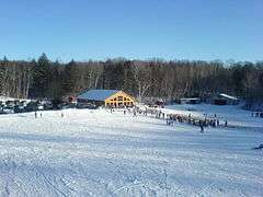 The Kettlebowl Ski Area near Bryant lies along the trail
 Northern landscape in Lincoln County's New Wood State Wildlife Area
See also
- Geological Features of Wisconsin
- List of hiking trails in Wisconsin
- Thomas Chrowder Chamberlin, Geology of Wisconsin (1877)
- Stages
- Quaternary glaciation
- Illinoian Stage
- Laurentide ice sheet
- Pleistocene
- Last glacial period
- Driftless Area
- Components
- Interglacial (longer warm period during ice age, such as today)
- Interstadial (brief warm period during ice age, weaker than interglacial)
- Stadial (brief cooler period during interglacial, such as Older Dryas, Younger Dryas, Little Ice Age)
- Little ice age
- Post-glacial rebound
- Timeline of glaciation
- Canadian Shield
- Glacial history of Minnesota
- Lake Agassiz
- Wisconsin glaciation
References
- ↑ Ice Age Trail National Park Service Web Site FAQ
- ↑ Ice Age Trail National Park Service Web Site - Management
- ↑ Ice Age Trail National Park Service Web Site - Partners
- ↑ Ice Age Trail Alliance Chapters
- 1 2 Ice Age Trail Alliance FAQ
- ↑ Timm's Hill Trail Web Site
- ↑ About.com article on National Trails system
- ↑ Ice Age Trail Alliance History
Further reading
- Ice Age Trail Alliance. Ice Age Trail Atlas.
- Ice Age Trail Alliance. Ice Age Trail Companion Guide 2011.
- Mittlefehldt, Sarah. "The origins of Wisconsin's Ice Age Trail: Ray Zillner's path to protect the past," Wisconsin Magazine of History, vol. 90, no. 3 (Spring 2007)
- Reuss, Henry S. (1990). On the trail of the Ice Age : a guide to Wisconsin’s Ice Age National Reserve and Trail for hikers, bikers, and motorists. Sheboygan, Wisconsin: Ice Age Park and Trail Foundation. ISBN 0-9627079-0-2. (inspired the Ice Age Trail in Wisconsin).
- Smith, Bart (2008). Along Wisconsin's Ice Age Trail. The University of Wisconsin Press. p. 104. ISBN 0-299-22664-6.
External links
| Wikimedia Commons has media related to Ice Age Trail. |
- Ice Age National Scenic Trail official website
- Ice Age Trail Alliance website
- Wisconsin DNR
- Hiking Journals and Photos from the Ice Age Trail
- Ice Age Trail Design Video produced by Wisconsin Public Television