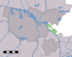
IJburg
| IJburg | |
|---|---|
| Neighbourhood of Amsterdam | |
 | |
| Country |
|
| Province | North Holland |
| COROP | Amsterdam |
| Borough | Amsterdam-Oost |
| Population | 20,986[1] |
IJburg is a residential neighbourhood under construction in 2013 in the east of Amsterdam, Netherlands. It is situated in the IJ Lake and is being built on artificial islands which have been raised from the lake. It is part of the borough of Amsterdam-Oost.[2]
History
In 1965, the architects Johannes Hendrik "Jo" van den Broek and Jacob Berend (Jaap) Bakema designed the Pampus Plan for a town in the IJ Lake which was to house 350,000 residents, most of whom were to come from Amsterdam. However, in national plans, another strategy was chosen, forcing people from Amsterdam to move to expanding towns in the area such as Purmerend, Hoorn, and the new town of Almere. As well as this, the Bijlmermeer was constructed to the south of the city and Diemen was expanded.
The 1980s saw a change of policy and construction sites nearer to the city were sought. As Amsterdam is located between Schiphol and nature reserves such as the Bovenkerkerpolder and Landelijk Noord, the only possible location became Nieuw-Oost (New East).
The Amsterdam city council decided to build the neighbourhood in 1996. Opponents of the plan called for a referendum as there were objections to possible negative effects for the nature of the IJ Lake. This referendum was held 19 March 1997. Although a majority of voters were against the construction, an insufficient number of votes was cast and construction could therefore be started.

Islands
IJburg consists of 6 artificial islands built in the IJ Lake. They are Steigereiland (Jetty island), Haveneiland West & East (Harbour island), and the 3 Rieteilanden (Reed islands), Large, Small, and East. The construction of, and building on, these six islands formed Phase 1.
Four more islands are planned to be constructed in the future. These islands will be called Centrumeiland (Centre island), Middeneiland (Middle island), Strandeiland (Beach island), and Buiteneiland (Outer island). The plans call for a total of ten islands to be constructed, but construction of these has been delayed by a Superior Administrative Court decision to annul the building permit of Phase 2 due to lack of consideration for the local environment. The main thoroughfare is IJburglaan (IJburg Avenue), which connects the islands. There is also a tram line connecting the islands to the city and Amsterdam Centraal Station (Route 26, Amsterdam's most modern tram line, and the only one to allow non-folding bicycles on board).
Residents

The first residents moved into their houses on Rieteiland in November 2002. Since then, people have moved into houses and flats on both Haveneiland and Steigereiland. Due to a slow take-up of properties, the construction of phase 1 was delayed for some years meaning that IJburg was not finished in 2012 as planned. In 2014 a new phase in construction began, new groups of houses were built on Rieteiland and the north-east part of the Haveneiland island is being extended to accommodate a series new buildings as well as a new beach.
When complete, the neighbourhood will have 18,000 homes for 45,000 residents and should also include employment for 12,000 people. As well as homes, schools, and shops; leisure centres, restaurants, a beach, and a cemetery are planned.
Bridges
IJburg is in the IJ Lake, and therefore, many bridges are necessary. The first bridge to be built, the Enneus Heerma Bridge (bridge 2001), connects Zeeburgereiland with Steigereiland. This bridge is the main route to IJburg and is also used by the tram. The bridge, designed by the English architect Nicholas Grimshaw was built in 2000 and, with two spans of 75 metres, is one of the biggest bridges in Amsterdam.
Bridge 2002 was designed by the same architect and is a smaller version of bridge 2001. This bridge connects Steigereiland to Haveneiland. The tram also uses this bridge.
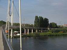
IJburg's pedestrians and cyclists also have their own bridge connecting them to the Ooster Ringdijk and Watergraafsmeer, in the form of the Nescio Bridge, whose southern end terminates in an expansive spiral cycle ramp. It is named after the writer Frits Grönloh, whose pen name was Nescio (Latin for "I don't know").
References
External links
- IJburg's official website in Dutch
- 'www.ijbrug.nl', Website for people of IJburg by people of IJburg!
- IJburg 3rd richest postcode in Nederland
- IJburg 3rd richest postcode in Nederland
Neighborhoods of Amsterdam | ||
|---|---|---|
| Centrum (Centre) | ||
| Nieuw-West (New West) | ||
| Noord (North) | ||
| Oost (East) |
| |
| West | ||
| Zuid (South) | ||
| Zuidoost (Southeast) |
| |
| Westpoort |
| |
Add'l. former boroughs: De Baarsjes - Geuzenveld-Slotermeer - Oost-Watergraafsmeer - Oud-West - Oud-Zuid - Slotervaart - Westerpark - Zeeburg - Zuideramstel | ||
Coordinates: 52°21′18″N 4°59′52″E / 52.35500°N 4.99778°E