Hwawangsan
| Hwawangsan 화왕산 火旺山 | |
|---|---|
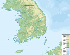 Hwawangsan Location in South Korea | |
| Highest point | |
| Elevation | 757 m (2,484 ft) |
| Coordinates | 35°32′52″N 128°31′58″E / 35.54778°N 128.53278°ECoordinates: 35°32′52″N 128°31′58″E / 35.54778°N 128.53278°E |
| Geography | |
| Location | Gyeongsangnam-do, South Korea |
| Geology | |
| Mountain type | Arête |
| Climbing | |
| First ascent | not recorded |
| Easiest route | Hiking route 1 |
Hwawangsan (Korean: 화왕산; Hanja: 火旺山) or Hwawang, is a mountain in Changnyeong County of South Gyeongsang Province, southeastern South Korea. It has an elevation of 757 metres.[1]
Etymology
The name Hwawang is from Korean hwawang, meaning "energetic fire", from hwa (Korean: 화; Hanja: 火), meaning "fire", and wang (Korean: 왕; Hanja: 旺), meaning "vigorous".
The name originated from the fire festival and practice of burning dry weeds and rice fields that took place every year on January 15.
Overview
It is one of the three primary tourist locations in Changnyeong County.[2] On January 11, 1984, it was designated as a national park.[3]
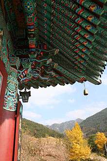
Changnyeong Temple at the base of Mount Hwawang
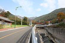
Road to Mount Hwawang (화왕산) in Changnyeong town
See also
References
- ↑ An Gyeong-ho (2007). 한국 300 명산 (300 Korean Mountains). Seoul: 깊은솔 (Gipeunsol). ISBN 978-89-89917-21-2.
- ↑ Changnyeong town website
- ↑ Korean Mountain Hiking news

This article is issued from Wikipedia - version of the 12/6/2015. The text is available under the Creative Commons Attribution/Share Alike but additional terms may apply for the media files.