Hürtgen Forest
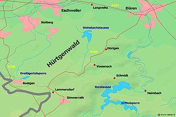
The Hürtgen forest (also: Huertgen Forest; German: Hürtgenwald) is located along the border between Belgium and Germany in the southwest corner of the German federal state of North Rhine-Westphalia. Scarcely 50 square miles (130 km2) in area, the forest lies within a triangle outlined by the German towns of Aachen, Monschau, and Düren. The Rur River runs along the eastern edge of the forest.
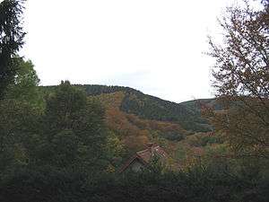
The Hürtgen Forest lies at the northern edge of the Eifel mountains; its terrain is characterized by plunging valleys that carve through broad plateaus. Unlike many areas of Germany in which the valleys are farmed and hilltops are wooded, the Hürtgen Forest's deep valleys are thickly wooded and the hilltop plateaus have been cleared for agriculture. The forest's rough terrain starkly contrasts with that of the adjoining Rhine Valley. Roads in the forest are few, winding, and narrow.
The rugged terrain of this area was the scene of a long, bloody, drawn-out battle during World War II, often referred to as the Battle of Hürtgen Forest, which took place over five months during a very cold winter from 19 September 1944 to 10 February 1945. Along a road that rises from the Kall River Valley to the town of Schmidt, there is still a length of tank track that melted into the road after a U.S. armored vehicle was hit and burned there.
In popular culture
HBO made a film about the Battle of the Hurtgen Forest, When Trumpets Fade (1998).
Coordinates: 50°42′03″N 6°25′42″E / 50.7008°N 6.4284°E