1900 Galveston hurricane
| Category 4 major hurricane (SSHWS/NWS) | |
_SWA.JPG) Surface weather analysis of the hurricane on September 8, just before landfall. | |
| Formed | August 27, 1900 |
|---|---|
| Dissipated | September 17, 1900 |
| (Extratropical after September 11, 1900) | |
| Highest winds |
1-minute sustained: 145 mph (230 km/h) |
| Lowest pressure | 936 mbar (hPa); 27.64 inHg |
| Fatalities | 6000–12,000 direct |
| Damage |
$21 million (1900 USD) (equivalent to $598 million in 2015, adjusted for inflation; see §Aftermath for more) |
| Areas affected | Lesser Antilles, Puerto Rico, Hispaniola, Jamaica, Cuba, Turks and Caicos Islands, Bahamas, Florida, Mississippi, Louisiana, Texas, Oklahoma, Kansas, Nebraska, Iowa, Illinois, Wisconsin, Michigan, New York, Eastern Canada |
| Part of the 1900 Atlantic hurricane season | |
The Great Galveston Hurricane was a Category 4 storm, with winds of up to 145 mph (233 km/h), which made landfall on September 8, 1900, in Galveston, Texas, in the United States, leaving about 6,000 to 12,000 dead. It remains to the present day the deadliest single day event in US history.
The hurricane appears to have started as an atmospheric trough from West Africa, causing unsettled weather in the Caribbean, and emerging into the Florida Straits as a tropical storm on September 5. Owing to contradictory forecasts, the people of Galveston felt no alarm until the official hurricane warning of September 7. Next morning a storm surge of 15 ft (4.6 m) washed over the long, flat island-city which was only 8 ft (2.4 m) above sea level, knocking buildings off their foundations and destroying over 3,600 homes.
The disaster ended the Golden Era of Galveston, as the hurricane alarmed potential investors, who turned to Houston instead. The whole island of Galveston was presently raised by 17 ft (5.2 m) and a 10 sq mi (26 km2) seawall erected.
Deadliest US hurricane
The Hurricane of 1900, also known as the Great Galveston Hurricane,[1] made landfall on September 8, 1900, in Galveston, Texas, in the United States.[2] It had estimated winds of 145 miles per hour (233 km/h) at landfall, making it a Category 4 storm on the Saffir–Simpson Hurricane Scale. It was the deadliest hurricane in US history, and the second costliest hurricane in U.S. history based on the dollar's 2005 value (to compare costs with those of Hurricane Katrina and others).
The hurricane caused great loss of life with a death toll of between 6,000 and 12,000 people;[3] the number most cited in official reports is 8,000, giving the storm the third-highest number of deaths or injuries of any Atlantic hurricane, after the Great Hurricane of 1780 and 1998's Hurricane Mitch. The Galveston Hurricane of 1900 is the deadliest natural disaster ever to strike the United States. The second-deadliest storm to strike the United States, the 1928 Okeechobee hurricane, caused more than 2,500 deaths, and the deadliest storm of recent times, Hurricane Katrina, claimed the lives of approximately 1,800 people.
The hurricane occurred before the practice of assigning official code names to tropical storms was instituted, and thus it is commonly referred to under a variety of descriptive names. Typical names for the storm include the Galveston Hurricane of 1900, the Great Galveston Hurricane, and, especially in older documents, the Galveston Flood. It is often referred to by Galveston locals as the Great Storm or the 1900 Storm.

Meteorological history

The storm's origins are unclear, because of the limited observation ability at the end of the 19th century. Ship reports were the only reliable tool for observing hurricanes at sea, and because wireless telegraphy was in its infancy, these reports were not available until the ships put in at a harbor. The 1900 storm, like many powerful Atlantic hurricanes, is believed to have begun as a Cape Verde–type hurricane—a tropical wave moving off the western coast of Africa. The first formal sighting of the hurricane's precursor occurred on August 27, about 1,000 miles (1,600 km) east of the Windward Islands, when a ship recorded an area of "unsettled weather". The storm passed through the Leeward Islands on August 30, probably as a tropical depression as indicated by barometric pressure reports from Antigua.[4]
Three days later, Antigua reported a severe thunderstorm passing over, followed by the hot, humid calmness that often occurs after the passage of a tropical cyclone. By September 1, U.S. Weather Bureau observers were reporting on a "storm of moderate intensity (not a hurricane)" southeast of Cuba. Continuing westward, the storm made landfall on southwest Cuba on September 3, dropping heavy rains. On September 5, it emerged into the Florida Straits as a tropical storm or a weak hurricane.[4] The Weather Bureau ignored reports from Cuban meteorologists because they expected the storm to curve northeast along the coast of North America: "Assumption became fact as the official government reports stated, wrongly, that the storm was traveling northeast in the Atlantic." However, a region of high pressure had pushed the storm to the west into the Gulf of Mexico.[5]
The storm was reported to be north of Key West on September 6,[6] and in the early morning hours of Friday, September 7, the Weather Bureau office in New Orleans, Louisiana, issued a report of heavy damage along the Louisiana and Mississippi coasts. Details of the storm were not widespread; damage to telegraph lines limited communication.[7] The Weather Bureau's central office in Washington, D.C., ordered storm warnings raised from Pensacola, Florida, to Galveston. By the afternoon of September 7, large swells from the southeast were observed on the Gulf, and clouds at all altitudes began moving in from the northeast. Both of these observations are consistent with a hurricane approaching from the east. The Galveston Weather Bureau office raised its double square flags; a hurricane warning was in effect. The ship Louisiana encountered the hurricane at 1 p.m. that day after departing New Orleans. Captain Halsey estimated wind speeds of 100 mph (160 km/h). These winds correspond to a Category 2 hurricane in the modern-day Saffir–Simpson Hurricane Scale.[4]

By early afternoon on Saturday, September 8, a steady northeastern wind had picked up. By 5 p.m., the Bureau office was recording sustained hurricane-force winds. That night, the wind direction shifted to the east, and then to the southeast as the hurricane's eye began to pass over the island just west of the city. By 11 p.m., the wind was southerly and diminishing. On Sunday morning, clear skies and a 20 mph (30 km/h) breeze off the Gulf of Mexico greeted the Galveston survivors.[4] The storm continued on, and later tracked into Oklahoma. From there, it continued over the Great Lakes while still sustaining winds of almost 40 mph (as recorded over Milwaukee, Wisconsin) and passed north of Halifax, Nova Scotia, on September 12, 1900.[8] From there it traveled into the North Atlantic where it disappeared from observations,[3] after decimating a schooner fleet fishing off the coast of Newfoundland.
Background
At the end of the 19th century, the city of Galveston, Texas, was a booming town with a population of 36,000 residents.[9] Its position on the natural harbor of Galveston Bay along the Gulf of Mexico made it the center of trade and one of the biggest cities in the state of Texas. With this prosperity came a sense of complacency.[7]
A quarter of a century earlier, the nearby town of Indianola on Matagorda Bay was undergoing its own boom and was second to Galveston among Texas port cities. Then in 1875, a powerful hurricane blew through, nearly destroying the town. Indianola was rebuilt, though a second hurricane in 1886 caused residents to simply give up and move elsewhere.[10] Many Galveston residents took the destruction of Indianola as an object lesson on the threat posed by hurricanes. Galveston is built on a low, flat island, little more than a large sandbar along the Gulf Coast. These residents proposed a seawall be constructed to protect the city, but their concerns were dismissed by the majority of the population and the city's government.[11]
Since its formal founding in 1839, the city of Galveston had weathered numerous storms, all of which the city survived with ease. Residents believed any future storms would be no worse than previous events.[12] In order to provide an official meteorological statement on the threat of hurricanes, Galveston Weather Bureau section director Isaac Cline wrote an 1891 article in the Galveston Daily News in which he argued not only that a seawall was not needed to protect the city, but also that it would be impossible for a hurricane of significant strength to strike the island.[13] The seawall was not built, and development activities on the island actively increased its vulnerability to storms. Sand dunes along the shore were cut down to fill low areas in the city, removing what little barrier there was to the Gulf of Mexico.[14]
Preparations
On September 4, the Galveston office of the National Weather Service began receiving warnings from the Bureau's central office in Washington, D.C., that a "tropical storm" had moved northward over Cuba. The Weather Bureau forecasters had no way of knowing where the storm was or where it was going. At the time, they discouraged the use of terms such as tornado or hurricane to avoid panicking residents in the path of any storm event. Conditions in the Gulf of Mexico were ripe for further strengthening of the storm. The Gulf had seen little cloud cover for several weeks, and the seas were as warm as bathwater, according to one report. For a storm system that feeds off moisture, the Gulf of Mexico was enough to boost the storm from a tropical storm to a hurricane in a matter of days, with further strengthening likely.[4]

Weather Bureau forecasters believed the storm would travel northeast and affect the mid-Atlantic coast. "To them, the storm appeared to have begun a long turn or 'recurve' that would take it first into Florida, then drive it northeast toward an eventual exit into the Atlantic."[15] Cuban forecasters adamantly disagreed, saying the hurricane would continue west. One Cuban forecaster predicted the hurricane would continue into central Texas near San Antonio. Early the next morning, the swells continued despite only partly cloudy skies. Largely because of the unremarkable weather, few residents heeded the warning. Few people evacuated across Galveston's bridges to the mainland, and the majority of the population was unconcerned by the rain clouds that began rolling in by midmorning.
Isaac Cline claimed that he took it upon himself to travel along the beach and other low-lying areas warning people personally of the storm's approach.[16] These reports by Cline and his brother, Galveston meteorologist Joseph L. Cline,[17] have been called into question in recent years, as no other survivors corroborated these accounts. In fact, Cline's role in the disaster is the subject of some controversy. Supporters point to Cline's issuing a hurricane warning without permission from the Bureau's central office;[18] detractors (including author Erik Larson) point to Cline's earlier insistence that a seawall was unnecessary and his belief that an intense hurricane could not strike the island.
Impact
Texas evacuees
The first train to reach Galveston left Houston on the morning of September 8 at 9:45 a.m. It found the tracks washed out, and passengers were forced to transfer to a relief train on parallel tracks to complete their journey. Even then, debris on the track slowed the train's progress to a crawl. The 95 travelers on the train from Beaumont found themselves at the Bolivar Peninsula waiting for the ferry that would carry them, train and all, to the island. When it arrived, the high seas forced the ferry captain to give up on his attempt to dock. The train crew attempted to return the way they had come, but rising water blocked the train's path.[19]
Ten refugees from the Beaumont train sought shelter at the Point Bolivar lighthouse with 200 residents of Port Bolivar who were already there. The 85 who stayed with the train died when the storm surge overran the tops of the cars.[20]
Galveston
| “ | First news from Galveston just received by train which could get no closer to the bay shore than 6 sq mi (16 km2) where the prairie was strewn with debris and dead bodies. About 200 corpses counted from the train. Large steamship stranded 2 sq mi (5.2 km2) inland. Nothing could be seen of Galveston. Loss of life and property undoubtedly most appalling. Weather clear and bright here with gentle southeast wind. | ” |
| — G.L. Vaughan Manager, Western Union, Houston, in a telegram to the Chief of the U.S. Weather Bureau on the day after the hurricane, September 9, 1900[21] | ||
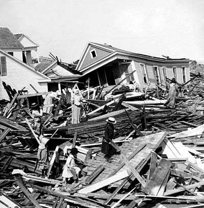
At the time of the 1900 storm the highest point in the city of Galveston was only 8.7 feet (2.7 m) above sea level.[13] The hurricane brought with it a storm surge of over 15 feet (4.6 m),[22] which washed over the entire island. The surge knocked buildings off their foundations and the surf pounded them to pieces. Over 3,600 homes were destroyed[22] and a wall of debris faced the ocean.[16] The few buildings which survived, mostly solidly built mansions and houses along the Strand District, are today maintained as tourist attractions.
The highest measured wind speed was 100 miles per hour (160 km/h) just after 6 p.m., but the Weather Bureau's anemometer was blown off the building shortly after that measurement was recorded.[13] The eye passed over the city around 8 p.m. Maximum winds were estimated at 120 mph (190 km/h) at the time, though later estimates placed the hurricane at the higher Category 4 classification on the Saffir–Simpson Hurricane Scale.[23] The lowest recorded barometric pressure was 28.48 inHg (964.4 hPa), considered at the time to be so low as to be obviously in error.[3] Modern estimates later placed the storm's central pressure at 27.49 inHg (930.9 hPa), but this was subsequently adjusted to the storm's official lowest measured central pressure of 27.63 inHg (935.7 hPa).[24]

As severe as the damage to the city's buildings was, the human toll was even greater. Because of the destruction of the bridges to the mainland and the telegraph lines, no word of the city's destruction was able to reach the mainland.[25] At 11 a.m. on September 9, one of the few ships at the Galveston wharfs to survive the storm, the Pherabe, arrived in Texas City on the western side of Galveston Bay. It carried six messengers from the city. When they reached the telegraph office in Houston at 3 a.m. on September 10, a short message was sent to Texas Governor Joseph D. Sayers and U.S. President William McKinley: "I have been deputized by the mayor and Citizen's Committee of Galveston to inform you that the city of Galveston is in ruins." The messengers reported an estimated five hundred dead; this was considered to be an exaggeration at the time.[26]
The citizens of Houston knew a powerful storm had blown through and had made ready to provide assistance. Workers set out by rail and ship for the island almost immediately. Rescuers arrived to find the city completely destroyed. It is believed 8,000 people—20% of the island's population—had lost their lives.[27] Estimates range from 6,000 to 12,000.[3] Most had drowned or been crushed as the waves pounded the debris that had been their homes hours earlier. Many survived the storm itself but died after several days being trapped under the wreckage of the city, with rescuers unable to reach them. The rescuers could hear the screams of the survivors as they walked on the debris trying to rescue those they could. A further 30,000 were left homeless.[28]

The dead bodies were so numerous that burying all of them was impossible. The dead were initially weighted down on barges and dumped at sea, but when the gulf currents washed many of the bodies back onto the beach, a new solution was needed.[29] Funeral pyres were set up on the beaches, or wherever dead bodies were found, and burned day and night for several weeks after the storm. The authorities passed out free whiskey to sustain the distraught men conscripted for the gruesome work of collecting and burning the dead.[20] More people were killed in this single storm than the total of those killed in all the tropical cyclones that have struck the United States since. This count is greater than 300 cyclones, as of 2009. The Galveston Hurricane of 1900 remains the deadliest natural disaster in U.S. history.[30]
Midwest
The storm maintained tropical characteristics and Saffir–Simpson tropical storm-force winds (39–50 mph) when it crossed the Upper Midwest, with more than 4 inches (100 mm) of rain being reported over most of the southern third of Wisconsin. Wind created problems all over, including over Lake Michigan, and other areas in the path of the storm had similar problems. (Tropical storms reach Wisconsin and surrounding areas to the east, west, and south once every 50 years on average with others in the 19th century, 1961, and (subject to debate) Hurricane Ike in 2008; tropical depressions hit twice to three times every two years; and subtropical storms and depressions hit equally or more rarely than their tropical counterparts.)
New York City
The rapidly moving storm was still exhibiting winds of 65 mph (105 km/h) by the time it reached New York City on September 12, 1900.[31] The New York Times reported that pedestrian-walking became difficult and that one death was attributed to the storm. A sign pole, snapped by wind, landed on a 23-year-old man, crushing his skull and killing him instantly, while two others were knocked unconscious. Awnings and signs on many buildings broke and the canvas roofing at the Fire Department headquarters was blown off.[32]
Closer to the waterfront, along the Battery seawall, waves and tides were reported to be some of the highest in recent memory of the fishermen and sailors. Spray and debris were thrown over the wall, making working along the waterfront dangerous. Small craft in New York Harbor were thrown off course and tides and currents in the Hudson River made navigation difficult. In Brooklyn, The New York Times reported that trees were uprooted, signs and similar structures were blown down, and yachts were torn from moorings with some suffering severe damage. Because of the direction of the wind, Coney Island escaped the fury of the storm, though a bathing pavilion at Bath Beach suffered damage from wind and waves.[32]
Aftermath
| Rank | Hurricane | Season | Cost (2015 USD)[35] |
|---|---|---|---|
| 1 | "Miami" | 1926 | $190.3 billion |
| 2 | Katrina | 2005 | $130.9 billion |
| 3 | "Galveston" | 1900 | $120.4 billion |
| 4 | "Galveston" | 1915 | $82.3 billion |
| 5 | Andrew | 1992 | $67.5 billion |
| 6 | "New England" | 1938 | $47.5 billion |
| 7 | "Cuba–Florida" | 1944 | $46.9 billion |
| 8 | "Okeechobee" | 1928 | $40.6 billion |
| 9 | Ike | 2008 | $34.1 billion |
| 10 | Donna | 1960 | $32.4 billion |
| Main article: List of costliest Atlantic hurricanes | |||
| Rank | Hurricane | Season | Fatalities |
|---|---|---|---|
| 1 | "Galveston" | 1900 | 8,000–12,000† |
| 2 | "Okeechobee" | 1928 | 2,500+† |
| 3 | Katrina | 2005 | 1,836 |
| 4 | "Cheniere Caminada" | 1893 | 1,100–1,400* |
| 5 | "Sea Islands" | 1893 | 1,000–2,000† |
| 6 | "Florida Keys" | 1919 | 778 |
| 7 | "Georgia" | 1881 | 700† |
| 8 | Audrey | 1957 | 416 |
| 9 | "Labor Day" | 1935 | 408 |
| 10 | "Last Island" | 1856 | 400† |
| †estimated total Reference: Deadliest US hurricanes[36] | |||
In less than 24 hours the city was effectively obliterated. The final death toll is not known with certainty but the most conservative estimate is around 6,000. Most historians believe the loss of life to be in the area of 8,000 with some suggesting as many as 12,000 perished. With the city in ruins and rail lines to the mainland destroyed, the survivors had little to live on until relief arrived.[37]
Rebuilding
Survivors set up temporary shelters in surplus U.S. Army tents along the shore. They were so numerous that observers began referring to Galveston as the "White City on the Beach". Others constructed so-called "storm lumber" homes, using salvageable material from the debris to build shelter.[38]
Reporter Winifred Bonfils, a young journalist working for William Randolph Hearst, was the first reporter on the line at the flood's aftermath. She delivered an exclusive set of reports and Hearst sent relief supplies by train.[39]
By September 12, Galveston received its first post-storm mail. The next day, basic water service was restored, and Western Union began providing minimal telegraph service. Within three weeks, cotton was again being shipped out of the port.[22]
Before the Hurricane of 1900, Galveston was considered to be a beautiful and prestigious city and was known as the "Ellis Island of the West" and the "Wall Street of the Southwest".[40] However, after the storm, development shifted north to Houston, which was enjoying the benefits of the oil boom. The dredging of the Houston Ship Channel in 1909 and 1914 ended Galveston's hopes of regaining its former status as a major commercial center.[41]
Protection
To prevent future storms from causing destruction like that of the 1900 hurricane, many improvements to the island were made. The first 3 miles (4.8 km) of the Galveston Seawall, 17-foot (5 m) high, were built beginning in 1902 under the direction of Henry Martyn Robert. An all-weather bridge was constructed to the mainland to replace the ones destroyed in the storm.
The most dramatic effort to protect the city was its raising. Dredged sand was used to raise the city of Galveston by as much as 17 feet (5.2 m) above its previous elevation. Over 2,100 buildings were raised in the process,[16] including the 3,000-ton St. Patrick's Church. The seawall and raising of the island were jointly named a National Historical Civil Engineering Landmark by the American Society of Civil Engineers in 2001.
In 1915, a storm similar in strength and track to the 1900 hurricane struck Galveston. The 1915 storm brought a 12-ft (4-m) storm surge which tested the new seawall. Although 53 people on Galveston Island lost their lives in the 1915 storm, this was a great reduction from the thousands who died in 1900.[42]
The Galveston city government was reorganized into a commission government, a newly devised structure wherein the government is made of a small group of commissioners, each responsible for one aspect of governance. This was prompted by fears that the existing city council would be unable to handle the problem of rebuilding the city.
Today, Galveston is home to a cruise port, two universities, and a major insurance corporation. Homes and other buildings that survived the hurricane have been preserved, and give much of the city a Victorian look. The seawall, since extended to 10 miles (16 km), is now an attraction itself, as hotels and tourist attractions have been built along its length in seeming defiance of future storms.
The last reported survivor of the Galveston Hurricane of 1900, Mrs. Maude Conic of Wharton, Texas, died November 14, 2004, at the claimed age of 116,[43] although the 1910 census and other records indicate she was younger than that.[44]
Historiography
In historiography, the hurricane and the rebuilding afterward divide what is known as the Golden Era (1875–1900) from the Open Era (1920–1957) of Galveston. The most important long-term impact of the hurricane was to confirm fears that Galveston was a dangerous place to make major investments in shipping and manufacturing operations; the economy of the Golden Era was no longer possible as investors fled. In 1920, Prohibition and tax law enforcement opened up new opportunities for criminal enterprises related to gambling and bootlegging in the city. Galveston rapidly became a prime resort destination enabled by the open vice businesses on the island. This new entertainment-based economy brought decades-long prosperity to the island.
Museum
The Galveston Historical Foundation maintains the Texas Seaport Museum at Pier 21 in the port of Galveston. Included in the museum is a documentary titled The Great Storm, that gives a recounting of the 1900 hurricane.[45][46]
Gallery
-

St. Lucas Terrace - 80 bodies were found under the ruins after this photograph was made -
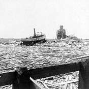
Floating wreckage near Texas City – typical scene for miles along the water front -

Carrying out bodies just removed from the wreckage, Galveston -
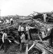
Relief party working at Ave P and Tremont St -

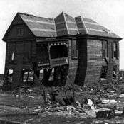
Twisted house -
The only remaining house near the beach for miles, Galveston, Texas -

Wrecked Negro High School building -

St Patrick's Church
In popular culture
- 1934: "Wasn't That a Mighty Storm" is an American folk song concerning the 1900 Galveston hurricane that originated as a spiritual and was revived and popularized by Eric Von Schmidt and Tom Rush in the 1960s.[47][48]
- 1935: Film director King Vidor was born in Galveston and survived the great Galveston Hurricane of 1900. Based on that experience, he published a fictionalized account of that cyclone, titled "Southern Storm", for the May 1935 issue of Esquire magazine. Erik Larson excerpts a passage from that article in his 2005 book, Isaac's Storm:[30]
I remember now that it seemed as if we were in a bowl looking up toward the level of the sea. As we stood there in the sandy street, my mother and I, I wanted to take my mother's hand and hurry her away. I felt as if the sea was going to break over the edge of the bowl and come puring down upon us.
- 1946: Meteorologist Joseph L. Cline, who with his brother Isaac Cline played a pivotal role in the hurricane, shares his account of the storm in an autobiography titled When the Heavens Frowned.[17]
- 1999: In Isaac's Storm, Erik Larson describes the storm and the pivotal roles played by Galveston Weather Service director Isaac Cline and his meteorologist brother Joseph Cline.[30]
- 2004: Canadian writer Paul Quarrington's novel Galveston, although set on a Caribbean island in the present day, centers on two storm chasing characters who share a lifelong obsession with historical accounts of the Galveston hurricane.[49]
- 2009: Ain Gordon's play A Disaster Begins centers on the Galveston hurricane.[50]
- 2013: Widow's Tears, a China Bayles mystery novel by Susan Wittig Albert
- 2013: The Promise, an historical fiction novel by Ann Weisgarber
- 2015: The Curious World of Calpurnia Tate, a children's novel by Jacqueline Kelly
- 2015: The Storm of the Century: Tragedy, Heroism, Survival, and the Epic True Story of America's Deadliest Natural Disaster: The Great Gulf Hurricane of 1900, a nonfiction account of the hurricane by Al Roker
See also
- List of Atlantic hurricanes
- List of deadliest Atlantic hurricanes
- Hurricane Ike (2008)
- List of floods
- List of tropical cyclones
- List of United States disasters by death toll
Notes
- ↑ Trumbla, Ron. "The Great Galveston Hurricane of 1900" NOAA Celebrates 200 Years of Science, Service and Stewardship
- ↑ Gibson, Christine. "Our 10 Greatest Natural Disasters" American Heritage (August/September 2006). Archived from the original on December 3, 2008
- 1 2 3 4 Weems, John Edward. "Galveston Hurricane of 1900", Handbook of Texas Online
- 1 2 3 4 5 Frank, Neil L. "The Great Galveston Hurricane of 1900" (PDF). AGU. Archived from the original (PDF) on March 25, 2009. Retrieved September 9, 2008.
- ↑ Ackerman, Steven A. Meteorology: Understanding the Atmosphere (4th ed.). Burlington, Mass.: Jones & Bartlett. p. 263.
- ↑ Colby, Frank Moore; et al. (1901). The International Year Book. Dodd, Mead & Company. p. 859.
- 1 2 McComb, David G. "Handboox of Texas: Galveston". TSHA handbook. Archived from the original on March 2, 2008. Retrieved September 9, 2008.
- ↑ Garriott, E. B. (September 1900). "West Indian Hurricane of September 1–12, 1900" (PDF). Monthly Weather Review. 28 (9): 371–377. Bibcode:1900MWRv...28..371G. doi:10.1175/1520-0493(1900)28[371b:WIHOS]2.0.CO;2. Retrieved February 25, 2009.
- ↑ Westcott, Kathryn (September 22, 2005). "Flashback: Galveston's great storm". BBC. Archived from the original on September 15, 2008. Retrieved September 9, 2008.
- ↑ Frantz, Helen B. "Handboox of Texas Online: Indianola Hurricanes". Archived from the original on July 30, 2007. Retrieved November 27, 2008.
- ↑ Hansen, Gunnar (1993). Islands at the Edge of Time: A Journey to America's Barrier Islands. Island Press. p. 69. ISBN 978-1-55963-252-2.
- ↑ Although that view was not universally held by all Texas residents, particularly those advocating other Texas seaports, e.g., see Braman, D. E. E. (1857). Braman's Information About Texas. Philadelphia: J. B. Lippincott & Co. p. 46. Retrieved July 15, 2009.
Galveston Island, with all its boasted accumulation of people, habitations, wealth, trade and commerce, is but a waif of the ocean, a locality but of yesterday ... liable, at any moment, and certain, at no distant day, of being engulfed and submerged by the self-same power that gave it form. Neither is it possible for all the skillful devices of mortal man to protect this doomed place against the impending danger; the terrible power of a hurricane cannot be ... resisted. I should as soon think of founding a city on an iceberg.
- 1 2 3 Heidorn, Keith C. Weather people and history: Dr Isaac M. Cline: A Man of Storm and Floods —Part 2. The Weather Doctor (September 1, 2000). Retrieved on December 18, 2007.
- ↑ Ramos, Mary G. (2008). "After the Great Storm: Galveston's Response to the Hurricane of September 8, 1900". Texas Almanac. Archived from the original on September 28, 2008. Retrieved September 9, 2008.
- ↑ Larson (1999), p. 111
- 1 2 3 "The 1900 Storm: An Island Washed Away" Galveston Newspapers Inc. Retrieved on December 18, 2007.
- 1 2 Cline, Joseph (January 31, 2000). When the Heavens Frowned. Firebird Press. ISBN 978-1-56554-783-4.
- ↑ Hurst, David. "Washington bureaucrats of the U.S. Weather Bureau prevented Isaac Cline, a weather forecaster on duty in Galveston at the time, from issuing a hurricane warning" Altoona Mirror (September 25, 2008)
- ↑ Larson, Erik (2000). Isaac's storm : a man, a time, and the deadliest hurricane in history (1st Vintage Books ed.). New York: Vintage Books. pp. 160–166. ISBN 0-375-70827-8.
- 1 2 Olafson, Steve (August 28, 2000). "Unimaginable devastation: Deadly storm came with little warning". Houston Chronicle. Archived from the original on December 17, 2007. Retrieved December 18, 2007.
- ↑ Larson, Erik (1999) "Day 7 | Part 1: Telegram"
- 1 2 3 Cline, Isaac M. "Galveston Storm of 1900: Introduction" National Oceanic and Atmospheric Administration. Retrieved on December 18, 2007.
- ↑ The Galveston storm of 1900—The deadliest disaster in American history. National Oceanic and Atmospheric Administration. Retrieved from February 13, 2007, version at archive.org on December 18, 2007.
- ↑ "Galveston Hurricane of 1900". ESSEA. Retrieved September 11, 2008.
- ↑ "Galveston May be Wiped Out By Storm" (PDF). The New York Times. September 9, 1900. Retrieved November 20, 2007.
- ↑ Green, Nathan C. (1900). Story Of The Galveston Flood. Baltimore: R. H. Woodward Company. p. 126. Retrieved July 15, 2009.
- ↑ Sullivan, Brian K.; Korosec, Tom (September 12, 2008). "Hurricane Ike Set to Slam Texas Coast; Thousands Flee (Update1)". Bloomberg. Retrieved September 11, 2008.
- ↑ Coe, Fanny E. (1911). Heroes of Everyday Life. Ginn and Co. p. 28.
- ↑ Storms of the century: 1900 Galveston Hurricane: Part 2 – Disaster Waiting to Happen. The Weather Channel. Retrieved on December 18, 2007. Archived June 24, 2007, at WebCite
- 1 2 3 Larson (1999)
- ↑ "Course of the Hurricane; Circuitous Route by Which the Storm has Traveled. ITS PATH 4,000 MILES LONG From Porto Rico to Florida and Texas, Then Through the Middle West and the Lake Belt to Montreal". The New York Times. September 13, 1900. Retrieved September 10, 2008. (subscription required (help)).
- 1 2 "City swept by high winds; The Storm that Wrecked Galveston Reaches New York. A MAN KILLED IN BROADWAY Struck by a Broken Banner Pole – Navigation in the Bay and Rivers Difficult – A Ferryboat's Plight". The New York Times. September 13, 1900. Retrieved September 10, 2008. (subscription required (help)).
- ↑ Pielke, Roger A., Jr.; Gratz, Joel; Landsea, Christopher W.; Collins, Douglas; Saunders, Mark A.; Musulin, Rade (2008). "Normalized Hurricane Damage in the United States: 1900–2005" (PDF). Natural Hazards Review. 9 (1): 29–42. doi:10.1061/(ASCE)1527-6988(2008)9:1(29). Archived from the original (PDF) on June 17, 2013. Retrieved May 7, 2009.
- ↑ Blake, Eric S.; Landsea, Christopher W.; Gibney, Ethan J. (2011). "The Deadliest, Costliest, and the most intense United States Tropical Cyclones from 1851 to 2010 (and other frequently requested hurricane facts)" (PDF). NOAA Technical Memorandum NWS NHC-6.
- ↑ United States nominal Gross Domestic Product per capita figures follow the Measuring Worth series supplied in Johnston, Louis; Williamson, Samuel H. (2016). "What Was the U.S. GDP Then?". MeasuringWorth. Retrieved April 10, 2016. These figures follow the figures as of 2015.
- ↑ Blake, Eric S; Landsea, Christopher W; Gibney, Ethan J; National Climatic Data Center; National Hurricane Center (August 10, 2011). The deadliest, costliest and most intense United States tropical cyclones from 1851 to 2010 (and other frequently requested hurricane facts) (PDF) (NOAA Technical Memorandum NWS NHC-6). National Oceanic and Atmospheric Administration. p. 47. Retrieved August 10, 2011.
- ↑ "Hurricane destroyed Galveston in 1900". CNN. 8 September 2008. Retrieved 5 October 2016.
- ↑ Bixel, Patricia Bellis; Turner, Elizabeth Hayes (2000). Galveston and the 1900 Storm. University of Texas Press. pp. 70–71. ISBN 978-0-292-70884-6.
- ↑ Kramarae, Cheris; Treichler, Paula A.; Russo, Ann (1992). Amazons, Bluestockings and Crones. Pandora. p. 434. ISBN 978-0-04-440863-5.
- ↑ History of Galveston Island. Galveston.com & Company, Inc. Retrieved on December 18, 2007
- ↑ "J.H.W. Stele to Sayers, September 11–12, 1900". Texas State Library and Archives Commission, Retrieved on August 31, 2007
- ↑ Frankenfield, H. S. (1915). "August 1915 Monthly Weather Review" (PDF). Weather Bureau. Retrieved September 11, 2008.
- ↑ "Oldest living Texas Republican celebrates 113th birthday" El Paso County Republican Party (September 2001). Retrieved on December 18, 2007. Archived September 19, 2008, at the Wayback Machine.
- ↑ "Table of False and Exaggerated Claims" Gerontology Research Group website. Retrieved on September 8, 2012.
- ↑ "Pier 21 Theater: The Great Storm". galvestonhistory.org. Retrieved 29 May 2012.
- ↑ "The Great Storm". galvestonhistory.org. Retrieved 29 May 2012.
- ↑ Hinckley, D. (September 12, 2008). "Singing up a 'Mighty Storm' in Galveston". Daily News. New York. Retrieved September 3, 2010.
- ↑ "Wasn't That a Mighty Storm (lyrics)". The Mudcat Café. Retrieved September 3, 2010.
- ↑ "Stormy tale holds moments of clarity". Calgary Herald, May 15, 2004.
- ↑ Saltz, Rachel (October 15, 2009). "Seeking Order in a Life, a War and a Deluge". The New York Times.
Further reading
- "1900 Storm". The 1900 Storm 1900storm.com. Galveston Newspapers, Inc. Retrieved December 18, 2007.
- Bixel, Patricia Bellis; Turner, Elizabeth Hayes (2000). Galveston and the 1900 Storm: Catastrophe and Catalyst (1st ed.). University of Texas Press. ISBN 978-0-292-70883-9.
- Garriott, E. B. (October 1900). "The West Indian Hurricane Of September 1–12, 1900". National Geographic Magazine. XI (10): 384–392. Retrieved July 15, 2007.
- Greene, Casey Edward; Kelly, Shelly Henley (2000). Through a Night of Horrors: Voices from the 1900 Galveston Storm. Texas A&M University Press. ISBN 978-1-58544-228-7.
- Halstead, Murat (1900). Galveston: The Horrors Of A Stricken City. American Publishers' Association. Retrieved July 15, 2009.
- Larson, Erik (1999). Isaac's Storm: A Man, A Time, and the Deadliest Hurricane in History (1st ed.). New York: Crown Publishers. ISBN 978-0-609-60233-1.
- Lienhard, John H. "Raising Galveston". The Engines of Our Ingenuity. University of Houston. Retrieved December 18, 2007.
- McGee, W. J. (October 1900). "The Lessons Of Galveston". The National Geographic Magazine. XI (10): 377–383. Retrieved July 15, 2007.
- Moore, Willis L. (October 1900). "The Weather Bureau and the Gulf Storms". The National Magazine. XIII (1): 542–546. Retrieved July 15, 2009.
- Moore, Willis L. (1901). Report of the Chief of the Weather Bureau, 1900–1901. 1. Washington: U.S. Department of Agriculture, Weather Bureau (Government Printing Office). pp. 9–10. Retrieved July 15, 2007.
- Ousley, Clarence (October 1900). "Thrilling Experiences In The Galveston Storm". The National Magazine. XIII (1): 533–542. Retrieved July 15, 2009.
- Ousley, Clarence (1900). Galveston in Nineteen Hundred: The Authorized and Official Record. Atlanta, Georgia: William C. Chase. Retrieved July 15, 2009.
- Weems, John Edward (1957). Weekend in September. Texas A&M University Press. ISBN 978-0-89096-390-6.
External links
| Wikimedia Commons has media related to Galveston Hurricane of 1900. |

- Sept. 11, 1900: Galveston wiped out Wire service account published in the Minneapolis Tribune
- 1900 Great Storm Theater Galveston Historical Foundation's website
- Galveston Hurricane of 1900 Texas Archive of the Moving Image
- Galveston 1900: Storm of the Century Primary Source Adventure, a lesson plan hosted by The Portal to Texas History
- Celebrating 200 years of NOAA from the NOAA (as well as similar content from the NOAA History Archives)
- The 1900 Storm – manuscripts, photographs, and other archival holdings from the Galveston and Texas History Center at the Rosenberg Library – including a list of victims
- The 1900 Storm – Galveston Island, Texas – "Remembering the Great Hurricane, September 8, 1900 – A Galveston County Daily News Presentation"
- The early history of Galveston, by Dr. J. O. Dyer, published 1916, hosted by the *Portal to Texas History
- The great Galveston disaster, containing a full and thrilling account of the most appalling calamity of modern times including vivid descriptions of the hurricane, published 1900, hosted by the Portal to Texas History