Hurricane Karl (2010)
| Category 3 major hurricane (SSHWS/NWS) | |
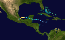
 Hurricane Karl viewed from the Terra satellite. | |
| Formed | September 14, 2010 |
|---|---|
| Dissipated | September 18, 2010 |
| Highest winds |
1-minute sustained: 125 mph (205 km/h) |
| Lowest pressure | 956 mbar (hPa); 28.23 inHg |
| Fatalities | 22 total |
| Damage | $206 million (2010 USD) |
| Areas affected | Belize, Yucatán Peninsula, Veracruz |
| Part of the 2010 Atlantic hurricane season | |
Hurricane Karl was the most destructive tropical cyclone on record to strike the Mexican state of Veracruz.[1] The eleventh tropical storm, sixth hurricane, and fifth and final major hurricane of the 2010 Atlantic hurricane season, Karl formed from an area of low pressure which had formed off of the northern coast Venezuela on September 11. It crossed the Caribbean and was upgraded to Tropical Storm Karl on September 14. The cyclone made landfall on the Yucatan Peninsula of Mexico as a strong tropical storm, and then rapidly strengthened in the Bay of Campeche before it made landfall near Veracruz, Veracruz, on the central Mexican Gulf coast, as a major hurricane. This marked the first known time that a major hurricane existed in the Bay of Campeche.
As of September 23, 22 people have been confirmed killed, most of which were in the state of Veracruz. Final insured losses from the storm are estimated at $206 million USD as of January 2011.[2]
Meteorological history
The origins of Hurricane Karl were from the interaction between a surface trough and westward-tracking tropical wave. The trough—an elongated area of low pressure—emerged from an area of disorganized monsoonal convection just north of South America over the Windward Islands in early September.[3][4] A few days later, the wave, which had departed the coast of Africa on September 1, approached the area and merged with the trough by September 8 as it slowed.[5] For several days, the resultant low-pressure system lingered toward the west-northwest over the Caribbean Sea, and provided with a diffluent environment aloft it generated disorganized patches of convection.[6][7] Although the convection remained disassociated from the mean low feature, the overall wind circulation continued to become better defined at the surface. The development trend briefly became disrupted by September 13, however, with the surface low confirmed no longer to exist under the improving convective structure.[5] Conditions remained favorable for reorganization, and a small but consolidated circulation center developed by 2100 UTC September 14.[8] In real time, this marked the formation of Tropical Storm Karl when it was located about 270 mi (435 km) east of Chetumal, Mexico, though post-storm reanalysis revealed a tropical depression had in fact formed six hours earlier.[5][9]

With a predominant ridge anchored to its north along the Gulf of Mexico, Karl continued a generally westward motion for most of its duration. Supported by symmetrical upper-level outflow, the storm strengthened slowly over very high water temperatures in a low-shear environment.[10][11] Karl subsequently made its initial landfall on the southeastern coast of Yucatán as a strong tropical storm early on September 15, with estimated winds of 65 mph (100 km/h). As it moved inland, radar imagery from Belize depicted a developing eye, suggesting the storm might have reached hurricane status at the time.[12] Although the storm slowly weakened as it crossed the Yucatán, its cloud pattern remained well-organized, with a ring of deep convection surrounding an eye-like feature.[13] Around 0400 UTC September 16, the center of Karl emerged into the Bay of Campeche as it slowed slightly. Situated once again over warm waters in a favorable shear environment, Karl steadily intensified and reached hurricane status about 150 mi (240 km) off the coast of Campeche, Mexico, after reconnaissance found a developing eyewall. At the time, Karl co-existed with Hurricanes Igor and Julia, the first such occasion since 1998 with at least three simultaneous hurricanes in the North Atlantic.[14]
The hurricane entered a period of rapid intensification after steadily deepening for several hours; its cloud pattern quickly organized, and with cooling convective cloudtops the warm eye became well-defined.[15] Recurving toward the southwest along the building ridge, Karl became a Category 3 hurricane on September 17; it reached its peak intensity of 125 mph (205 km/h) only four hours prior to landfall.[16] Karl became the strongest hurricane ever observed in the Bay of Campeche upon attaining this intensity, a record previously set by Hurricane Item in 1950.[5] Despite a sudden increase in minimum central pressure, Karl retained its strength and moved ashore near Veracruz, Mexico as a major hurricane at 1645 UTC.[5] Once inland, the small storm rapidly weakened over the high terrain, and by early September 18 no deep convection remained around its increasingly disrupted circulation.[17] Around 0900 UTC, the system was declassified as a tropical cyclone as its low-level circulation dissipated, though patches of remnant thunderstorms continued to produce heavy precipitation over the country.[18]
Preparations
Western Caribbean

Upon the formation of a tropical cyclone, the government of Mexico issued a tropical storm warning for the east coast of the Yucatán Peninsula, extending from Chetumal northward to Cabo Catoche. Additionally, a tropical storm watch was in place for the coast of northern Belize, from Belize City to the Belize–Mexico border.[9] At the threat of a storm, authorities in Honduras declared a green alert for the entire country; a yellow alert was to remain in effect for 36 hours in the Bay Islands Department.[19][lower-alpha 1] El Cajón, a major hydroelectric power plant located in western Honduras, discharged some of its water reservoir into connecting rivers to prevent flooding of surrounding low-lying areas. Port officials along the coastlines were advised to take necessary precautions due to rough sea conditions.[20] In Belize, seaports secured their supplies and halted operations to ensure the safety of seafaring vessels and marine workers.[21] Schools were closed in the northern districts of Corozal and Orange Walk, as well as in San Pedro Town and Caye Caulker during the storm's passage.[22]
In Quintana Roo, officials opened shelters and ordered the evacuation of low-lying areas along the storm's projected path. Hundreds of people were displaced at Banco Chinchorro, an atoll reef and diving center near Majahual. In Carillo Puerto, located to the south of the archaeological ruins of Tulum, authorities readied concrete residences to provide shelter to some hundred communities of indigenous Mayans.[23] As Karl moved further inland, orange alerts were declared in Campeche for the municipalities of Hopelchén and Calakmul, while the rest of the state remained under yellow alert.[24] Shelters were opened near flood-prone areas in the cities of Campeche, Champotón and the municipality of Calkiní (Isla Arena). Local residents were urged not to take out their trash for three days, as collection services were to be suspended at the threat of torrential rainfall.[25]
Veracruz
The government of the Veracruz issued a red alert as Karl approached the state's coastline; eight municipalities were placed under mandatory coastal evacuation orders. Laguna Verde Nuclear Power Station, located in the Veracruz coastline, stopped its operations as a precaution. Additionally, Pemex evacuated its facilities on the Gulf of Mexico that were located in Karl's path.[26] World oil prices rose rapidly on September 17 as the company stopped production on 14 of its wells. The prices climbed 54 cents to 75.11 dollars a barrel.[27]
Impact

Yucatán Peninsula
As Karl struck the coast of Quintana Roo, heavy precipitation amounting up to 6.2 inches (157 mm) in some areas resulted in scattered flooding.[28] At the height of the storm, a total of 54,265 residents were without power, but most had their electricity restored within a day.[29] Some 600 homes in Chetumal suffered inundations of up to 4.9 ft (1.5 m), forcing hundreds of residents to evacuate.[28][30] High winds reportedly uprooted several trees in Bacalar, a small village near the city.[23] The municipalities of Othon P. Blanco, Carillo Puerto, and José María Morelos reported copious losses in agriculture; an estimated total of 11,650 hectares of crop were affected, with 3,477 hectares of maiz crop destroyed. Approximately 7,800 hectares of sugarcane along the banks of the Hondo River were lost, resulting in economic losses of Mex$76 million (US$6.23 million).[31] In Othon P. Blanco, 477 hectares of jalapeño chili peppers were lost while banana, cassava and citrus plantations in the area sustained significant wind damage.[32] In total, damage to roads, structures and properties in the municipality was estimated at Mex$120 million (US$9.9 million).[33]
Though there were no reports of major damage, strong winds in Belize downed utility poles, grounded water crafts and caused power outages along the Belize–Mexico border.[22] Further inland in Campeche, maximum 24-hour rainfall accumulations totaled no more than 0.95 inches (24 mm), and little damage was reported.[24][34] The storm left no fatalities in its wake in the peninsula, as its landfall occurred in a sparsely populated area.[35]
Gulf coast of Mexico

Succeeding one of Mexico's wettest seasons on record, torrential rains from Karl brought on historic flooding that lead to great destruction across Veracruz.[36] The heaviest precipitation occurred adjacent to and northward of the storm's track, with localized accumulations of up to 17.83 inches (455 mm) recorded in Misantla. On landfall, major-hurricane-force winds uprooted hundred thousands of trees and caused widespread power outages, leaving up to 280,000 customers in the dark.[37] The disaster affected at least 163 of the state's 212 municipalities, and several days after its passage more than half of the territory remained submerged by the flood waters.[38][36] It caused the largest population displacement in the region's history; about 150,000 residents evacuated to a total of 423 storm shelters statewide.[39] Karl claimed the lives of a confirmed twelve people in the state,[40][41] among which a 40-year-old woman, along with her two- and three-year-old grandchildren in Cotaxtla, and a 54-year-old and a 87-year-old in Felipe Carrillo.[42] Two other fatalities were however mentioned as being possibly attributed to the storm in an official government press release on September 24, 2010.[40]
In addition to the loss of life, structural damage in the state was widespread and particularly severe. In Cotaxtla, damaging muddy waters up to 12 m (39 ft) high left much of the municipality inundated and scores structures encased in mud. In some areas, the flooding was described as being "unprecedented".[43] Carrillo Puerto suffered similar damage; two people were reported missing in the city.[44] The impact on the vegetation was particularly notable in Boca del Río—situated near the mouth of the Jamapa River—where the winds downed well over 400,000 trees;[45] a consequent clogging of the river mouth prompted about 30,000 people to evacuate from adjacent areas.[46] In Puebla, two people were killed after their home was destroyed in a landslide.[47] A third person was killed in Tabasco after she drowned in her flooded home.[48] An estimated 200,000 residences were left without power as a result of Karl.[49]
In total, Karl killed 16 people and left 11 others missing.[44][50][51] An estimated 15.8 million people were affected by the storm throughout Mexico.[52] Preliminary assessments placed the damage from Karl in Veracruz at 70 billion MXN ($5.6 billion USD), although final estimates reduced it to about ($206 million USD).[53][54] In Puebla, losses from the storm reached 200 million MXN ($16 million USD).[55]
Aftermath

Following severe flooding triggered by Karl, roughly 3,500 people sought refuge in shelters set up at schools throughout Veracruz. Between 250,000 and 500,000 people are believed to have been left homeless as 120 municipalities throughout the state experience extensive floods. Emergency officials stated that all warnings would remain in place despite Karl having already passed to keep the public informed of lingering danger.[44] In the weeks following the hurricane, recovery crews cleared roughly 18,000 tonnes of debris throughout the state of Veracruz.[56]
See also
Notes
- ↑ The Central American hurricane alert system uses the colors blue, green, yellow, orange, and red to denote the scale of danger, with blue indicating the lowest threat and red the greatest.
Source: "Alerta Huracane". Bomberos y Protección Civil de Quintana Roo IAP. 2003. Retrieved January 30, 2011.
References
- ↑ Unattributed (December 14, 2010). "Tras temporada de huracanes, recuento de daños" (in Spanish). Crónica del Poder. Retrieved March 22, 2011.
- ↑ (Spanish) http://www.nhc.noaa.gov/data/tcr/AL132010_Karl.pdf
- ↑ Garcia, Felix (September 9, 2010). "Tropical Weather Discussion". National Hurricane Center. Retrieved January 25, 2010.
- ↑ Formosa, Mike (September 9, 2010). "Tropical Weather Discussion". National Hurricane Center. Retrieved January 25, 2010.
- 1 2 3 4 5 Stewart, Stacy R. (January 31, 2011). "Hurricane KARL Tropical Cyclone Report" (PDF). National Hurricane Center. Retrieved March 9, 2011.
- ↑ Huffman, Marshall (September 11, 2010). "Tropical Weather Discussion". National Hurricane Center. Retrieved January 25, 2010.
- ↑ Huffman, Marshall (September 13, 2010). "Tropical Weather Discussion". National Hurricane Center. Retrieved January 29, 2010.
- ↑ Beven, Jack (September 14, 2010). "Tropical Storm Karl Discussion One". National Hurricane Center. Retrieved January 29, 2011.
- 1 2 Beven, Jack (September 14, 2010). "Tropical Storm Karl Advisory One". National Hurricane Center. Retrieved January 29, 2011.
- ↑ Brown, Daniel (September 14, 2010). "Tropical Storm Karl Discussion Two". National Hurricane Center. Retrieved January 29, 2011.
- ↑ Pasch, Richard (September 15, 2010). "Tropical Storm Karl Discussion Thfree". National Hurricane Center. Retrieved January 29, 2011.
- ↑ Beven, Jack (September 15, 2010). "Tropical Storm Karl Discussion Four". National Hurricane Center. Retrieved January 29, 2011.
- ↑ Avila, Lixion (September 15, 2010). "Tropical Storm Karl Discussion Six". National Hurricane Center. Retrieved January 29, 2011.
- ↑ National Hurricane Center; Hurricane Research Division (July 6, 2016). "Atlantic hurricane best track (HURDAT version 2)". United States National Oceanic and Atmospheric Administration. Retrieved December 8, 2016.
- ↑ Avila, Lixion (September 16, 2010). "Tropical Storm Karl Discussion Eleven". National Hurricane Center. Retrieved January 29, 2011.
- ↑ Brennan, Michael (September 17, 2010). "Tropical Storm Karl Discussion Twelve". National Hurricane Center. Retrieved January 29, 2011.
- ↑ Avila, Lixion (September 18, 2010). "Tropical Storm Karl Discussion Fifteen". National Hurricane Center. Retrieved January 29, 2011.
- ↑ Avila, Lixion (September 18, 2010). "Tropical Storm Karl Discussion Sixteen". National Hurricane Center. Retrieved January 29, 2011.
- ↑ Staff Writer (September 14, 2010). "Honduras en alerta verde por formación de Karl" (in Spanish). La Prensa. Retrieved January 30, 2011.
- ↑ Portillo, José M. (September 15, 2010). "Fuertes lluvias dejará tormenta Karl en el país" (in Spanish). La Prensa. Retrieved January 30, 2011.
- ↑ Staff Writer (September 18, 2010). "Belice se prepara para recibir a la tormenta tropical Karl" (in Spanish). Por Descubrir. Retrieved January 30, 2011.
- 1 2 Staff Writer (September 16, 2010). "Belize reports no major damage from Tropical Storm Karl". CDEMA. Retrieved February 1, 2011.
- 1 2 Staff Writer (September 15, 2010). "Tormenta 'Karl' golpea costas mexicanas" (in Spanish). El Informador. Retrieved January 30, 2010.
- 1 2 Notimex (September 15, 2010). "Alertan a Campeche por llegada de tormenta "Karl"" (in Spanish). Provincia. Retrieved January 31, 2010.
- ↑ Pacheco, Martin A. (September 15, 2010). ""Karl" pone en alerta a Campeche" (in Spanish). Diario de Yucatán. Retrieved January 30, 2011.
- ↑ Ávila, Édgar (September 17, 2010). "Veracruz espera a un furioso huracán "Karl"". El Universal (in Spanish). Mexico City. Retrieved September 17, 2010.
- ↑ Pemex (September 17, 2010). "Oil prices rise as hurricane Karl shuts platforms". AFP. Archived from the original on September 17, 2010. Retrieved September 17, 2010.
- 1 2 Hernández, Silvia (September 15, 2010). "Karl, una de las peores tormentas: autoridades" (in Spanish). El Universal. Retrieved January 31, 2011.
- ↑ Staff Writer (September 16, 2010). "Daños eléctricos en Quintana Roo a causa de la tormenta "Karl"" (in Spanish). Artículo 7. Retrieved September 16, 2010.
- ↑ Staff Writer (September 16, 2010). ""Karl" sólo causa inundaciones en Quintana Roo y alerta en Campeche" (in Spanish). Yucatan Media. Retrieved September 16, 2010.
- ↑ Editor (September 21, 2010). "Suman casi 12 mil hectáreas de cultivos afectadas por "Karl"" (in Spanish). Noticaribe. Retrieved January 31, 2011.
- ↑ Editor (September 17, 2010). "Constatan daños en cultivos" (in Spanish). Noticaribe. Retrieved January 31, 2011.
- ↑ García, Luis E. (September 23, 2010). ""Karl" dejo 120 millones de pesos en daños en Othón P. Blanco" (in Spanish). Diario de Yucatán. Retrieved January 30, 2010.
- ↑ Notimix (September 16, 2010). "Karl deja Campeche sin causar daños" (in Spanish). El Universal. Retrieved February 1, 2011.
- ↑ Staff Writer (September 15, 2010). "Tropical storm Karl drenches Mexico". CBC News. Associated Press. Retrieved January 31, 2011.
- 1 2 Agence France-Presse (2010-09-21). "12 dead in Mexico hurricane, as looting spirals: officials". ReliefWeb. Retrieved 2011-08-31.
- ↑ (Spanish) Staff reporter (2010-09-18). "Hay 235 mil casas sin luz en Veracruz". El Informador. Unión Editorialista, S.A. Retrieved 2011-08-31.
- ↑ (Spanish) Morales, José (2010-09-18). "Afectados, 163 municipios "Karl" cambió trayectoria; no se perdió ni una vida". Diario de Xalapa. Organización Editorial Mexicana. Retrieved 2011-08-31.
- ↑ (Spanish) "Afectaciones Karl" (PDF). Government of Veracruz. 2010. p. 18. Retrieved 2011-09-09.
- 1 2 (Spanish) Staff writer (2010-09-20). "El número de muertos en Veracruz a causa de Karl sube a 12". CNN México. Retrieved 2011-09-09.
- ↑ (Spanish) Government of Mexico (2010-09-24). "México: Diversas intervenciones en Reunión de Evaluación por Daños Ocasionados por Karl". ReliefWeb. Retrieved 2011-09-09.
- ↑ Francisco Reséndiz (September 18, 2010). "Cinco muertos, el saldo por Karl". El Universal (in Spanish). Mexico City. Retrieved September 19, 2010.
- ↑ (Spanish) Danell, Verónica; Castaneyra, Doris; (Notimex) (2010-09-19). "Karl dañó a 250 mil en Veracruz; seis ríos desbordados". Excélsior. Grupo Imagen Multimedia. Retrieved 2011-08-31.
- 1 2 3 Excelsior (September 20, 2010). "Karl dañó a 250 mil en Veracruz; seis ríos desbordados" (in Spanish). Ahora Mismo. Retrieved September 20, 2010.
- ↑ (Spanish) Osorio, Iratze (2010-09-25). "Pasarán seis décadas para recuperar los más de 400 mil árboles perdidos por "Karl"". Boca del Río. Retrieved 2011-08-31.
- ↑ (Spanish) Contreras, Oved (2010-10-18). "Inició reconstrucción". Diario de Xalapa. Organización Editorial Mexicana. Retrieved 2011-08-31.
- ↑ Staff Writer (September 18, 2010). "Hurricane Karl kills 2, remnants drench Mexico". USA Today. Retrieved September 18, 2010.
- ↑ Staff Writer (September 18, 2010). "México: tres muertos tras el paso de Karl" (in Spanish). BBC. Retrieved September 18, 2010.
- ↑ Staff Writer (September 18, 2010). "El huracán "Karl" deja tres muertos y severos daños en México" (in Spanish). SPD Noticias. Retrieved September 18, 2010.
- ↑ Staff Writer (September 20, 2010). "El huracán "Karl" dejó al menos 16 víctimas en México" (in Spanish). Deia – Noticias de Bizkaia. Retrieved September 20, 2010.
- ↑ Staff Writer (September 20, 2010). "Hurricane Karl insured losses estimated at less than $400M". Business Insurance. Retrieved September 20, 2010.
- ↑ EL Universal (September 20, 2010). ""Karl" afecta a 15 millones de mexicanos" (in Spanish). El Mexicano. Retrieved September 20, 2010.
- ↑ Staff Writer (September 20, 2010). "Según cálculos de Kuri Grajales, Karl causó daños al estado por 12 mil mdp" (in Spanish). La Jordana Veracruz. Retrieved September 20, 2010.
- ↑ "Karl deja 1 millón damnificados y 3.900 millones dólares en daños en Veracruz" (in Spanish). EFE. September 21, 2010. Archived from the original on September 28, 2010. Retrieved September 28, 2010.
- ↑ Fabiola Reynoso Vázquez (September 23, 2010). "http://www.contraparteinformativa.com/despliegue-noticia.php?Noticias-Puebla--Danos-por-200-mdp-dejo-el-huracan-Karl:-Seproci&id=31201" (in Spanish). Contraparte Informativa. External link in
|title=(help); - ↑ Staff Writer (September 27, 2010). "Deja Karl daños por 70 mmdp, estima FHB" (in Spanish). Observatorio Político de Veracruz. Retrieved October 12, 2010.
External links
- The NHC's Tropical Cyclone Report on Hurricane Karl
- The NHC's Advisory Archive for Hurricane Karl
- The NHC's Graphic Archive for Hurricane Karl
| Wikimedia Commons has media related to Hurricane Karl (2010). |
Tropical cyclones of the 2010 Atlantic hurricane season | ||
|---|---|---|
 | ||
| ||