Hurricane Dora
| Category 4 major hurricane (SSHWS/NWS) | |
 Satellite image of Dora on September 5 | |
| Formed | August 28, 1964 |
|---|---|
| Dissipated | September 14, 1964 |
| Highest winds |
1-minute sustained: 130 mph (215 km/h) |
| Lowest pressure | 942 mbar (hPa); 27.82 inHg |
| Fatalities | 5 total |
| Damage | $250 million (1964 USD) |
| Areas affected | Leeward Islands, Bermuda, Florida, Alabama, Georgia, The Carolinas, Virginia, Maryland, Delaware, Northeastern United States, Atlantic Canada |
| Part of the 1964 Atlantic hurricane season | |
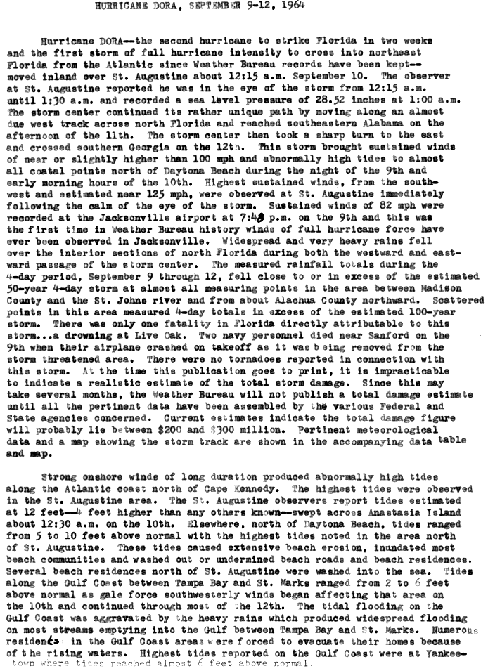
Hurricane Dora was first tropical cyclone on record to make landfall over the First Coast of Florida. The sixth tropical storm and second hurricane of the 1964 season, Dora developed from a tropical wave near the coast of Senegal on August 28. After a reconnaissance aircraft flight on September 1, the depression was upgraded to Tropical Storm Dora. It then curved northeastward and continued to strengthen. By early on September 3, Dora became a Category 1 hurricane. Six hours later, the storm reached Category 2 intensity. Intensification slowed somewhat, though Dora became a Category 3 on September 5. Deepening further, the storm peaked as a Category 4 with maximum sustained winds of 130 mph (215 km/h) early the following day. At 18:00 UTC on September 6, Dora weakened to a Category 3 hurricane, then a Category 2 hurricane while curving westward early the following day.
Later on September 7, Dora re-strengthened into a Category 3 hurricane. Approaching the east coast of Florida, Dora's motion became erratic, making a few cyclonic loops. Around 04:00 UTC on September 10, the hurricane made landfall near St. Augustine, Florida, with winds of 115 mph (185 km/h). Two hours later, Dora weakened to a Category 2 hurricane. However, deterioration then slowed, with the hurricane falling to tropical storm intensity over Jefferson County on September 11. Dora then briefly drifted over southwestern Georgia, until turned east-northeastward late the next day. Early on September 14, the storm re-emerged into the Atlantic Ocean near Cape Hatteras, North Carolina, and transitioned into an extratropical cyclone several hours later. The remnants of Dora moved rapidly northeastward and dissipated offshore Newfoundland early on September 16.
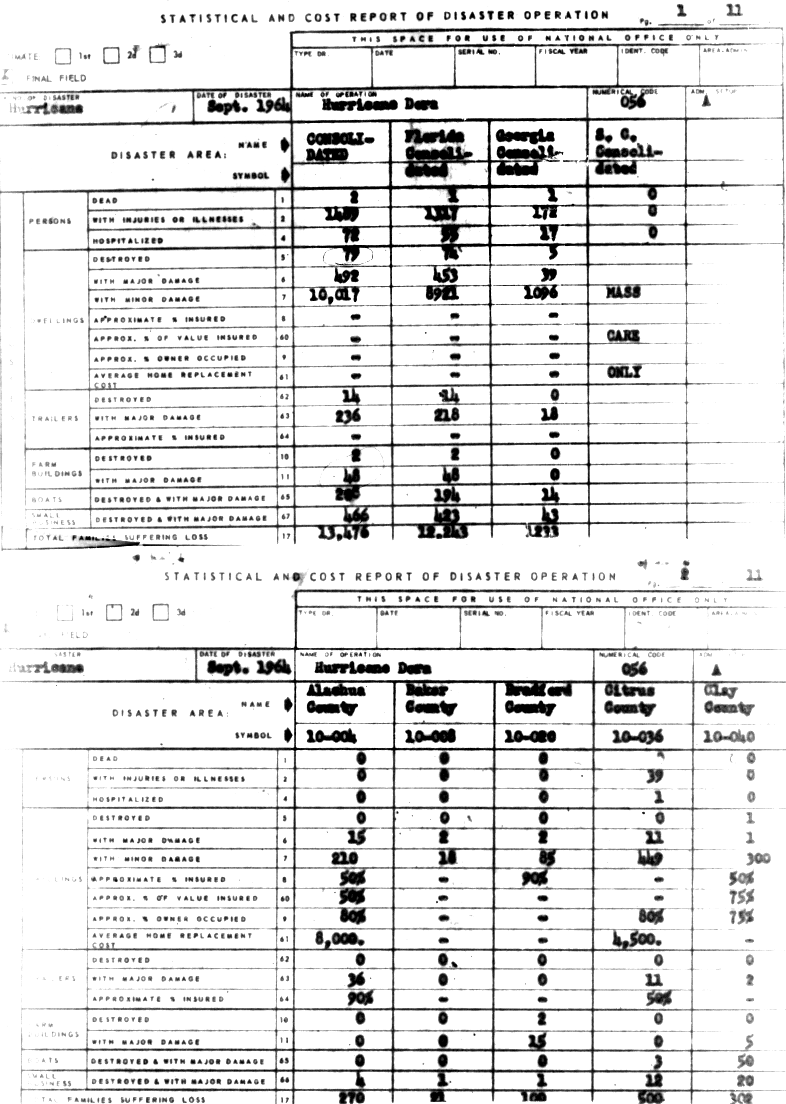
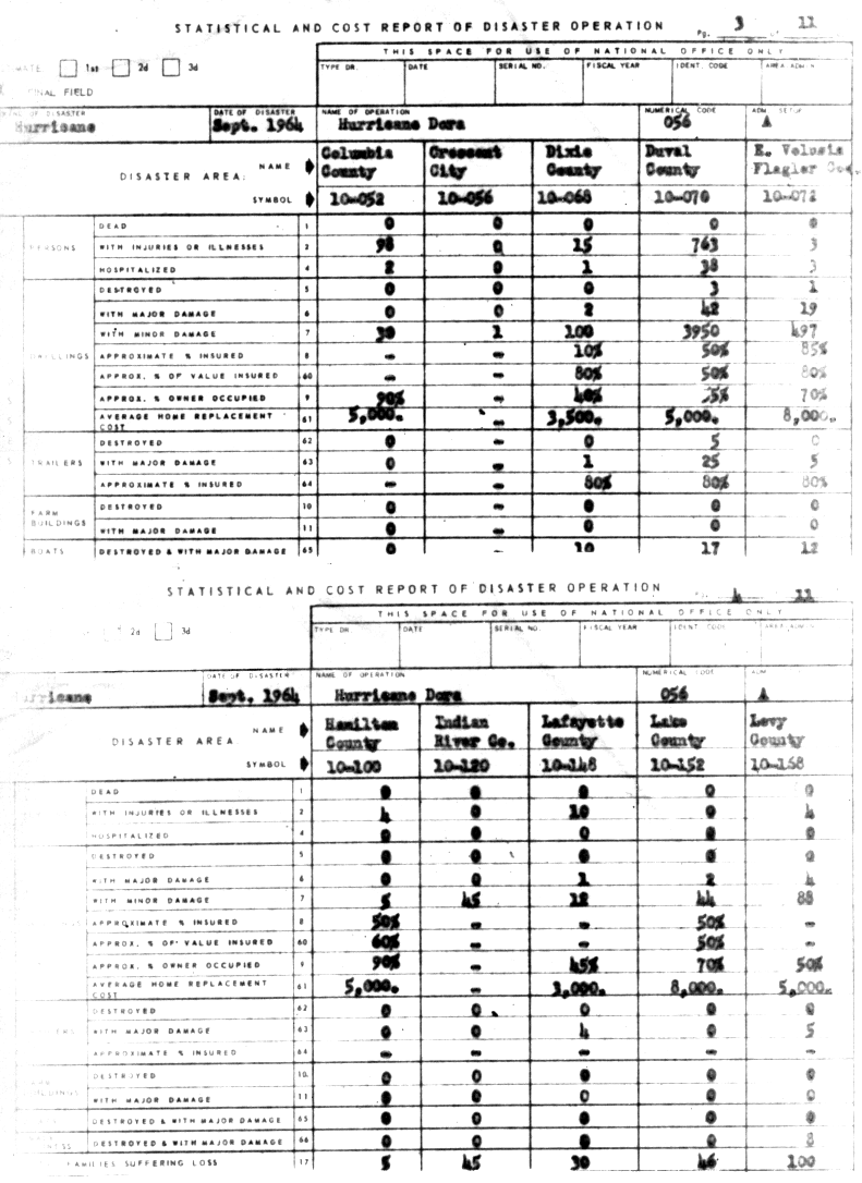
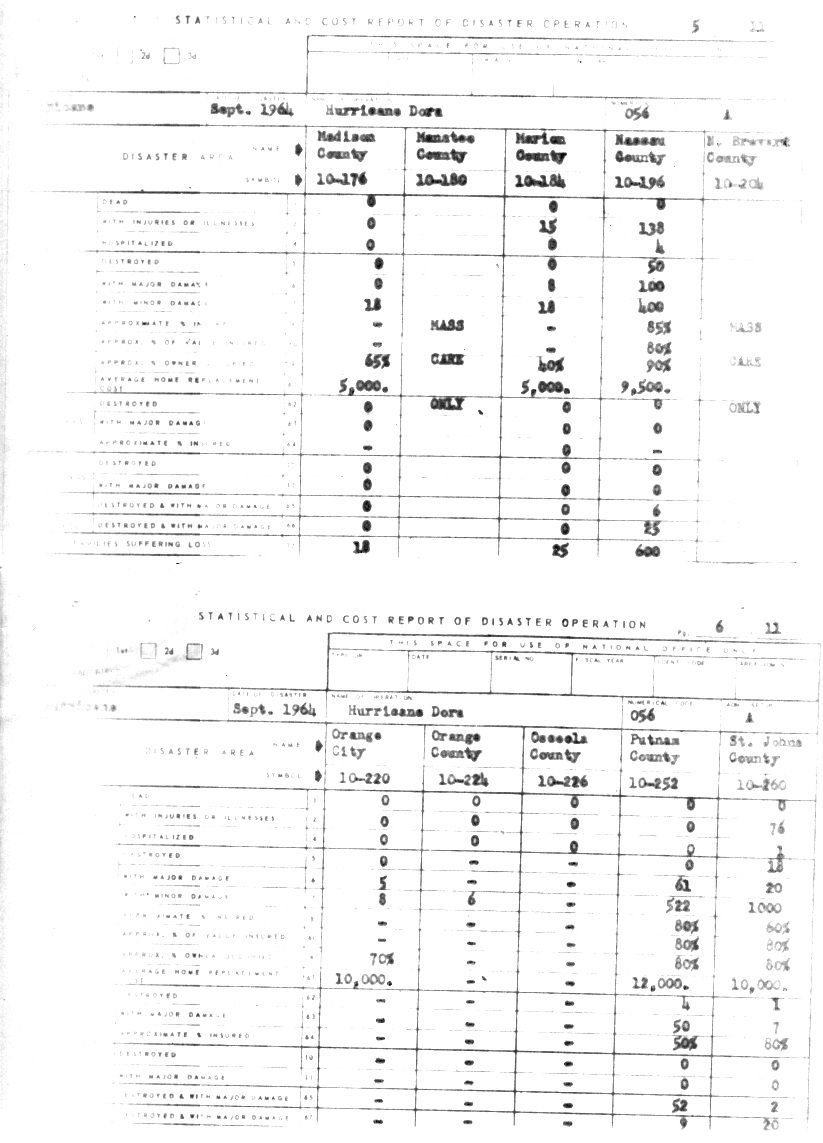
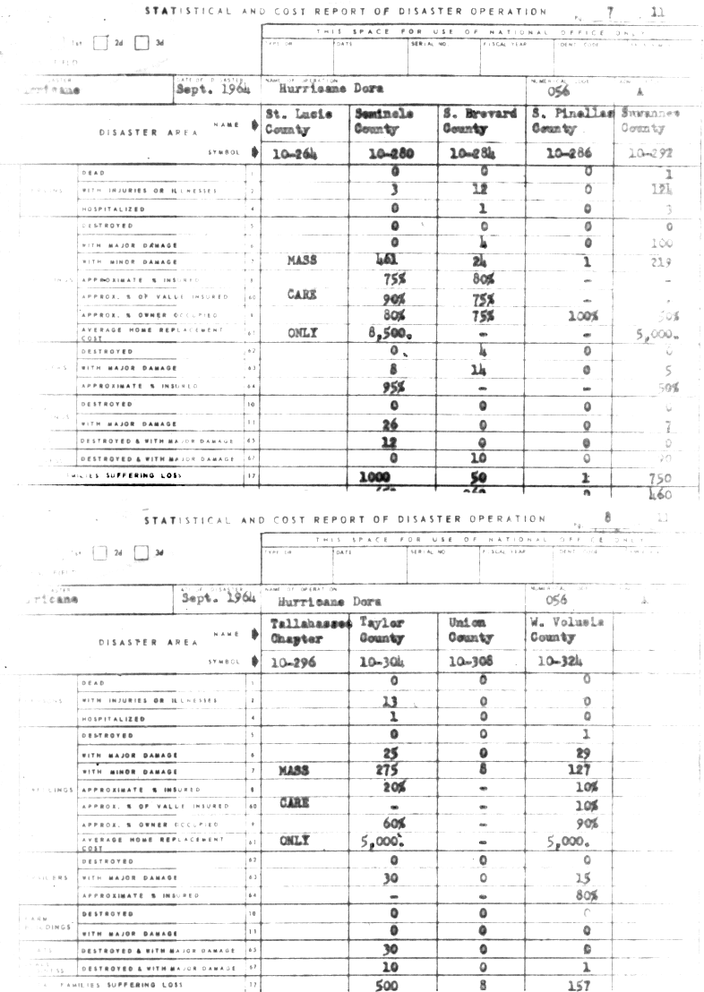
Along the coast, tides reached up to 10 ft (3.0 m) above mean sea level. Strong winds lashed North Florida, with sustained wind of 125 mph (205 km/h) observed in St. Augustine. In Jacksonville, approximately 156,000 customers were left without electricity, while about 19% of phones in Duval County were out of service. Much of the damage in the Jacksonville area occurred to older buildings and those located in coastal areas. Additionally, sections of the city experienced wind-induced river flooding in the vicinity of the St. Johns River. Heavy rainfall damaged many unharvested crops and inundated numerous of roads and bridges, isolated some communities for several days. Throughout Florida, 74 dwellings were flattened and 9,374 received damage, while 14 mobile homes were destroyed and 218 others suffered severe impact. About 50 farm buildings and 423 small businesses were severely damaged or demolished. Three deaths and at least $230 million in damage occurred. In Georgia, the storm damaged about 1,135 homes and obliterated five others. Additionally, 18 trailers suffered major impact, while 43 small businesses were destroyed or experienced severe damage. There was one death in the state and at least $9 million in damage. A few other states were affected by the storm, though impact there was much lesser. One death occurred in Virginia. Overall, Dora caused $280 million in damage and five deaths.
Meteorological history

Hurricane Dora was first identified as a broad area of low pressure on August 28, 1964, as it moved off the west coast of Africa into the Atlantic Ocean near Dakar, Senegal.[1] Traveling west-southwestward,[2] the system brushed the Cape Verde Islands the following day. By August 31, images from the eighth Television Infrared Observation Satellite (TIROS VIII) depicted a developing storm with a central dense overcast, banding features and cirrus outflow. Observations from ships in the vicinity of the storm indicated decreasing barometric pressures and wind gusts up to 40 mph (65 km/h). On September 1, reconnaissance aircraft flew into the system and determined that it had already become a tropical storm, with sustained winds reaching 60 mph (95 km/h). Shortly thereafter, the first advisory was issued on Tropical Storm Dora and the center was estimated to be roughly 850 mi (1,370 km) east of Trinidad.[1][3]
Upon being classified on September 1, Dora turned towards the northwest and intensified.[2] Several reconnaissance missions into the storm indicated that it attained hurricane status during the afternoon of September 2;[1] however, in the official Atlantic hurricane database, it is not listed as reaching this intensity until the nighttime hours.[2] Increasing in size and strength,[1] Dora attained winds of 100 mph (155 km/h) early on September 3, the equivalent of a Category 2 on the modern-day Saffir–Simpson Hurricane Scale.[2] At the time, meteorologists expected the storm to maintain a northwesterly course and be steered over open waters by a trough associated with Hurricane Cleo to the west.[3][4] However, Dora "missed" the trough and gradually turned towards the west on September 6.[3] That day, the hurricane attained its peak intensity as a Category 4 equivalent storm with winds estimated at 130 mph (215 km/h) and a central pressure of 942 mbar (hPa; 27.82 inHg).[2]

While executing the turn, Dora steadily weakened as its low-level inflow was disrupted. By September 8, the storm restrengthened slightly and attained winds of 115 mph (185 km/h).[1][3][2] Tracking westward towards Florida, Dora's forward movement decreased and became erratic as it neared the coast. Early on September 9, the storm abruptly turned southeastward before moving north for several hours. Throughout the remainder of September 9, the hurricane executed three distinct cyclonic loops while maintaining a general westward motion.[1] During the afternoon hours, Dora passed over the Gulf Stream, resulting in its central pressure decreasing 9 mbar (hPa; 0.27 inHg) in a few hours.[5]
Around 12:20 a.m. EST on September 10, Hurricane Dora made landfall about 6 mi (9.7 km) north of St. Augustine, Florida, with sustained winds between 115 and 125 mph (185 and 205 km/h).[1] Although estimated to have been a Category 3 at landfall, the highest winds onshore were believed to have been in the Category 2 range.[6] Striking northeastern Florida, Dora became the first tropical cyclone on record to make landfall in the region.[1] Once onshore the storm gradually weakened, losing hurricane status about 24 hours later, and began a gradual turn towards the northeast. During the morning of September 12, Dora became almost stationary over the southern border between Alabama and Georgia. However, the storm rapidly accelerated and re-emerged into the Atlantic Ocean on September 14 near the Outer Banks of North Carolina. Hours after moving over water, the system transitioned into an extratropical cyclone. The remnants of Dora were last mentioned on September 16 off the northeast coast of Newfoundland.[2]
Preparations
Caribbean
Upon Dora's classification on September 1, a small craft advisory was issued for the Leeward Islands and the northern Windward Islands.[3]
United States
As Dora approached Florida, gale warnings were issued for the northeast section of the coastline.[7] As Dora moved inland, gale warnings were issued from Sarasota to Pensacola.[8] In addition, small craft for much of the Gulf Coast to the west coast of Florida, and later in the Mid-Atlantic were advised to stay in port until the storm subsided.[8]
Impact
Overall, Hurricane Dora was responsible for five deaths and $280 million in damage, much of which occurred in Florida.[9]
Bahamas and Florida

In the Bahamas, Dora brought heavy rains and high winds to Nassau.[10] Along the coast of Florida, tides reached up to 10 ft (3.0 m) above mean sea level.[3] Strong winds lashed the area, with sustained wind of 125 mph (205 km/h) observed in St. Augustine.[3] Many locations north of Daytona Beach received sustained winds of at least 100 mph (160 km/h).[11] Because of the slow movement of Dora, some places experienced the worst of the storm for as much as 24 hours.[3] Many areas of North Florida received at least 10 in (250 mm) of rainfall, damaging many unharvested crops and inundating numerous roads and bridges, which isolated some communities for several days.[3] Throughout Florida, 74 dwellings were flattened and 9,374 received damage, while 14 mobile homes were destroyed and 218 others suffered severe impact. About 50 farm buildings and 423 small businesses were severely damaged or demolished.[12]
First Coast
Jacksonville was one of the most severely impacted cities. Approximately 156,000 customers were left without electricity, while about 19% of phones in Duval County were out of service. The power supply for Jacksonville and surrounding towns was lost for six days.[13] Much of the damage in the Jacksonville area occurred to older buildings and those located in coastal areas. Additionally, sections of the city experienced wind-induced river flooding in the vicinity of the St. Johns River.[3] Along the coast, Atlantic Beach and Jacksonville Beach were lashed by storm surge, which flooded low-lying areas and swept away homes and roads. One street in the latter was inundated with about 6 ft (1.8 m) of water. Three homes were destroyed and 3,992 suffered damage, while 5 mobile homes were demolished and 25 experienced impact, overall in Duval County.[14]

The storm was also one of the factors that nearly led to the cancellation of a Beatles concert at Gator Bowl Stadium in Jacksonville on September 11; other reasons included that the Beatles would not perform with a segregated audience, the American Guild of Variety Artists forced the Fab Four to pay union dues, and that a group of filmmakers attempted to create bootleg footage of the concert. Those issues were eventually resolved. Initially, the Beatles planned to fly to Jacksonville after their concert in Montreal on September 8, but the storm forced their plane to be diverted to Key West. Just hours before the concert began, the Beatles arrived at Imeson Field. More than 20,000 fans attended the concert, though thousands of others could not attend due to power outages in the city. Because winds were still gusting up to 45 mph (72 km/h), Ringo Starr's drums were nailed to the stage.[15]
In American Beach, which was once an African-American beach community established by Abraham Lincoln Lewis, many of its historical buildings were damaged or destroyed.[16] Additionally, several homes and businesses were also affected or demolished.[17] Some homes were swept away in Fernandina Beach, while the foundations of several other dwellings were threatened.[18] Approximately 40 residences were damaged or destroyed.[19] At Fort Clinch, located near the northern tip of Amelia Island, the exterior of the fort was severely impacted by erosion.[20] Throughout Nassau County, Dora destroyed about 50 homes and damaged 500 others, while 25 small businesses were either demolished or suffered major impact.[21]

In St. Johns County, 14 beach homes and 2 car garages were destroyed by erosion between Vilano Beach and southern Ponte Vedra Beach. A number of other dwellings were damaged. Waves inundated many areas of St. Augustine with a few inches to as much as several feet of water.[22] The heaviest impact occurred at the bay front, in Davis Shores, and along the San Sebastian River. At Slave Market Square, floodwaters were "hip deep",[23] while floodwaters outside the Monson Motor Lodge, where Martin Luther King, Jr. launched his St. Augustine movement, was described as "hubcap deep". The St. Augustine Record office was submerged,[24] while some motel lobbies along the Matanzas River were flooded with 30 in (760 mm) of water.[25] Additionally, Castillo de San Marcos was surrounded by water.[23] Winds unroofed some homes and downed giant, centuries old oak trees.[22] Much of the city was left without electricity. Damage in St. Augustine totaled about $5 million.[25] The pier and boardwalk at St. Augustine Beach were majorly damaged, as well as a section of State Road A1A, causing it to be closed to traffic.[24] Approximately 1,027 homes and 19 others were destroyed, while 20 businesses suffered major losses or were demolished in St. Johns County alone.[21]
High tides were also reported Flagler County, especially at Flagler Beach. About half of the municipal pier was destroyed, with some of its debris scattered over State Road A1A. In addition to the debris, washouts forced the road to be temporarily closed. Impact to private property was mainly limited to lost shingles, flooded yards, and a few downed trees. Seedling cabbage plants may have been completely ruined. Damage in the county was minor, reaching approximately $500,000.[26] Tides of about 8 ft (2.4 m) along the St. Johns River in Palatka threatened to wash away the eastern side of the memorial bridge. Extensive erosion occurred elsewhere in Putnam County along the river. A 75 ft (23 m) yacht was beached at a county commissioner's riverfront home. Then-State Road 309 was flooded in the vicinity of Georgetown.[27] Some trees were downed and a few classrooms suffered water leaks at St. Johns River Junior College in Palatka, but damage overall was minor.[28] Approximately 1,800 people were left without telephone service in Palatka, Pomona Park, and Welaka.[27]
North Central Florida and Florida Panhandle
West of the Jacksonville area, the storm brought heavy rainfall, with over 10 in (250 mm) of precipitation falling in a 10,000 sq mi (26,000 km2) area.[3]
In Ocala, 11.7 in (300 mm) of rain fell since September 1, about 11.46 in (291 mm) in association with Dora. A few blocks were closed in the city due to flooding.[29] One lane along Route 441 was inundated at Orange Lake. Throughout Marion County, 15 to 20 county roads were submerged. Additionally, Interstate 75 was flooded between Route 27 and County Road 318, resulting in the closure of that section of the highway.[30] The storm inflicted minor damage on 18 homes and severe impacts on 8 others residences in Marion County.[21] Further north in Gainesville, "scores" of dwellings and 25 homes at Highland Court Manor and Lincoln Estates were invaded by water. Several residences on Northwest 10th Avenue were also flooded. A trailer park on Archer Road was inundated waist-deep. At Clear Lake, several homes were threatened by the rising body of water. A 25,000 US gal (95,000 l; 21,000 imp gal) fuel tank at Stengel Field emerged from the ground due to saturation.[31] At the University of Florida, the half-basements of Anderson, Flint, Matherly, and Tigert halls were flooded, though classes remained in session while crews pumped out the water.[32] Throughout the city, saturation downed trees, some of which fell on power lines, roads, and houses. Damage in Gainesville alone exceeded $300,000.[31] Overall, 225 dwellings and 36 mobile homes in Alachua County were impacted, while 4 businesses received major damage or were destroyed.[12]
Rainfall peaked at 23.73 in (603 mm) in Mayo,[33] including 14.62 in (371 mm) that fell in a 24‑hour period. At Live Oak, 18.62 in (473 mm) of precipitation was observed over the course of four days. Flooding left the town almost completely isolated, with all highways leading into Live Oak closed. Portions of the downtown business district were inundated with more than 10 ft (3.0 m) of water. Some homes floated away, while others were flooded with water above the second story window. In a few neighborhoods, only the tops of the chimneys were visible. Many residents were stranded on their rooftops and required rescue by boats.[24] One person died directly as a result of the storm from a drowning in Live Oak.[11] Throughout Suwannee County, 100 homes suffered major damage, while 219 other dwellings were dealt minor impairments and 5 mobile homes received severe impacts. Additionally, seven farm buildings were extensively damaged and 80 small businesses suffered either destruction or significant effects.[34]
The hurricane also produced storm surge and abnormally high tides on the Gulf Coast of Florida, especially from Tampa Bay to St. Marks, where tides between 2 and 6 ft (0.61 and 1.83 m) were observed. Residents were forced to evacuate their homes.
Central Florida southward
In New Smyrna Beach, two concrete decks at the beach were swept away. More than 200 ft (61 m) of sand was lost at the Coast Guard station.[24] Strong winds downed power lines and trees, which struck six homes.[35] Sixty-three dwellings in Daytona Beach were damaged and over 1,000 sq ft (93 m2) of the roof at Daytona Beach International Airport was lost.[24] One house burned down in Glenwood, a community between DeLeon Springs and DeLand, after the owner forgot to extinguish a kerosene lantern before falling asleep.[36] In DeLand, winds uprooted many trees and caused power and telephone service outages. The winds and rainfall ranging from 6 to 7 in (150 to 180 mm) caused some losses of oranges and grapefruits.[35] In western Volusia County, one dwelling was destroyed and twenty-nine suffered major impact, while one hundred twenty-seven homes experienced minor damage. Additionally, 15 trailers were significantly impacted.[34]
Two deaths occurred on September 9 when a helicopter being evacuated from the storm crashed near Sanford, killing two Navy personnel.[3]
Elsewhere in North America

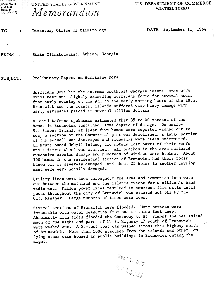
Some locations in Georgia also experienced hurricane-force winds and heavy rainfall from the storm, particularly in the southeastern portion of the state. Winds estimated at 90 mph (140 km/h) were experienced on the coastal islands, while gale force winds were observed as far north as Savannah and as far west as Waycross. Hundreds of trees were toppled, which downed trees and power lines, with some areas experiencing a near complete lost of electricity. The storm also brought heavy rainfall, with some areas observing more than 10 in (250 mm) of rain, while much of the southern half of Georgia experienced more than 3 in (76 mm) of precipitation. Storm surge and higher tides resulted in erosion and coastal flooding.[37] On Jekyll Island, two motels lost portions of their roofs and a ferris wheel was destroyed. Extensive erosion also occurred on the island.[38] Damage on Jekyll Island was conservatively estimated at $1 million.[39] At least five homes were swept away on St. Simons Island, while sections of the pier and seawall were demolished. The causeway connecting Sea Island and St. Simons Island to Brunswick was flooded.[38]
Many streets in Brunswick were covered with 1 to 3 ft (0.30 to 0.91 m) of water, leaving them impassible. In one section of the city, about 100 homes were deroofed, while 25 other homes in another section were severely damaged. An estimated 35%-40% of dwellings were damaged to some degree in Brunswick. Many trees, and power lines were downed, limiting communication between the islands and the mainland to radio networks. Portions of Route 17 south of Brunswick was washed out.[38] One man drowned in the Little Satilla River near Brunswick while attempting to secure his boat.[40] Glynn County suffered over $3.6 million in damage.[39] Soil erosion caused by heavy rainfall in Waycross resulted in extensive damage to buildings and streets.[38] Throughout Georgia, the storm structurally impacted about 1,135 homes and obliterated five others. Additionally, 18 trailers suffered major impact, while 43 small businesses were destroyed or experienced severe damage.[12] Although many pastures were flooded,[37] impact on agriculture was minor.[40] Overall, the storm left at least $9 million in damage in Georgia.[3]
A few other states were affected by the storm, though impact there was much lesser. One death occurred in Virginia.[3]
In Newfoundland, over 100 ships sought shelter at the St. John's harbor. The central portions of the province experienced heavy rainfall and winds up to 59 mph (95 km/h).[41]
Aftermath
Following the storm, President Lyndon Johnson toured the devastated area with Florida governor Farris Bryant, U.S. senators Spessard Holland and George Smathers, Jacksonville mayor and Democratic nominee for governor Haydon Burns. President Johnson also personally assessed the damage in coastal Georgia, including at Brunswick and St. Simons Island.[42] In the flooded areas, the Red Cross delivered typhoid serum by helicopter.[24]
The name "Dora" had replaced "Donna" on the hurricane lists, and it was retired from the Atlantic hurricane lists and replaced with "Dolly" for the 1968 season.
See also
- 1898 Georgia hurricane
- List of Atlantic hurricanes
- List of retired Atlantic hurricane names
- List of Florida hurricanes (1950-1974)
References
- 1 2 3 4 5 6 7 8 George Cry (1961). "Hurricane Dora Preliminary Report" (PDF). National Oceanic and Atmospheric Administration. Retrieved September 27, 2011.
- 1 2 3 4 5 6 7 National Hurricane Center; Hurricane Research Division (July 6, 2016). "Atlantic hurricane best track (HURDAT version 2)". United States National Oceanic and Atmospheric Administration. Retrieved December 8, 2016.
- 1 2 3 4 5 6 7 8 9 10 11 12 13 14 Gordon E. Dunn; Paul L. Moore; Gilbert B. Clark; Neil L. Frank; Elbert C. Hill; Raymond II Kraft; Arnold L. Sugg (March 1965). "The Hurricane Season of 1964" (PDF). Monthly Weather Review. National Oceanic and Atmospheric Administration. 93 (3): 175–187. Bibcode:1965MWRv...93..175D. doi:10.1175/1520-0493-93.3.175. Retrieved September 27, 2011.
- ↑ "New Hurricane Churns Waters Off Puerto Rico". United Press International. The Hartford Courant. September 15, 1964. Retrieved September 27, 2011.
- ↑ Irving Perlboth (May 1967). "Hurricane behavior as related to oceanographic environmental conditions" (PDF). 19 (2). Tellus: 258–268. doi:10.1111/j.2153-3490.1967.tb01481.x. Retrieved September 27, 2011.
- ↑ Christopher W. Landsea (May 30, 2014). "Frequently Asked Questions: E23) What is the complete list of continental U.S. landfalling hurricanes?". National Hurricane Center Hurricane Research Division. National Oceanic and Atmospheric Administration. Retrieved February 15, 2015.
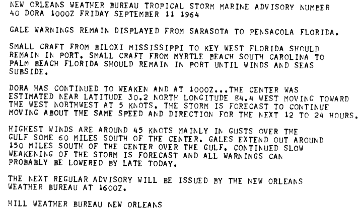
- ↑ Hill Weather Bureau in New Orleans (1964). "Hurricane Dora Public Advisory Number 40". National Hurricane Center. Retrieved 2008-02-01.
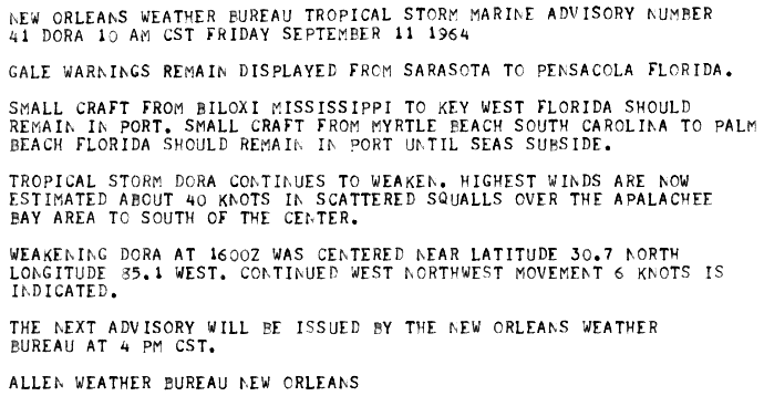
- 1 2 Allen Weather Bureau New Orleans (1964). "Hurricane Dora Public Advisory Number 41". NOAA. Retrieved 2008-02-01.
- ↑ Arnold L. Sugg (March 1967). "Economic Aspects of Hurricanes" (PDF). 95 (3). National Oceanic and Atmospheric Administration: 143–146. Bibcode:1967MWRv...95..143S. doi:10.1175/1520-0493(1967)095<0143:EAOH>2.3.CO;2. Retrieved September 27, 2011.
- ↑ Kevin Turner. It's time to consider hurricane preparations. Retrieved on 2008-06-16.
- 1 2 Hurricane Dora, September 9–12, 1964. U.S. Weather Bureau (Report). National Hurricane Center. 1964. Retrieved November 28, 2015.
- 1 2 3 Hurricane Dora Florida Damage Summary (Report). National Oceanic and Atmospheric Administration. 1964. p. 1. Retrieved September 1, 2015.
- ↑ Emergency Preparedness Guide Duval County Emergency Management 2014-2015 (PDF) (Report). Jacksonville, Florida: Duval County Emergency Management. 2014. Archived from the original (PDF) on July 18, 2014. Retrieved July 20, 2014.
- ↑ Hurricane Dora Florida Damage Summary (Report). National Oceanic and Atmospheric Administration. 1964. p. 3. Retrieved September 1, 2015.
- ↑ Tom Szaroleta (September 11, 2014). "The show that almost didn't happen: The Beatles perform at Jacksonville's Gator Bowl 50 years ago". The Florida Times-Union. Retrieved September 19, 2015.
- ↑ A1A Ocean Islands Trail Letter of Intent Information Package (PDF) (Report). Jacksonville, Florida: Northeast Florida Regional Council. December 13, 2013. p. 32. Retrieved September 18, 2015.
- ↑ "1964, Beginning of the End". Washington, D.C.: National Park Service. Retrieved September 18, 2015.
- ↑ "Dora Presents Threat to Gulf States". The Palm Beach Post. Tallahassee, Florida. United Press International. September 11, 1964. p. 2. Retrieved September 18, 2015.
- ↑ "Dora Presents Threat to Gulf States". The Palm Beach Post. Tallahassee, Florida. United Press International. September 11, 1964. p. 1. Retrieved September 18, 2015.
- ↑ Paula L. Allen (September 1, 2004). Fort Clinch State Park Unit Management Plan (PDF) (Report). Tallahassee, Florida: Florida Department of Environmental Protection. p. 10. Retrieved September 18, 2015.
- 1 2 3 Hurricane Dora Florida Damage Summary (Report). National Oceanic and Atmospheric Administration. 1964. p. 5. Retrieved September 19, 2015.
- 1 2 "Dora Deteriorates; Path Disaster Area". The Daytona Beach News-Journal. St. Augustine, Florida. Associated Press. September 11, 1964. pp. 1–2. Retrieved September 18, 2015.
- 1 2 "Atlantic Coast Ripped". Associated Press. Jacksonville, Florida: The Daytona Beach News-Journal. September 11, 1964. pp. 1–2. Retrieved September 18, 2015.
- 1 2 3 4 5 6 Jay Barnes (2007). Florida's Hurricane History. University of North Carolina Press. ISBN 978-0-8078-3068-0. Retrieved September 18, 2015.
- 1 2 George Allen (September 10, 1964). "Birthday Spoiled by Hurricane". St. Augustine, Florida: The Daytona Beach News-Journal. pp. 1–2. Retrieved September 18, 2015.
- ↑ "Flagler Pier Clipped". The Daytona Beach News-Journal. Flagler Beach, Florida. September 10, 1964. p. 2. Retrieved September 19, 2015.
- 1 2 "Palatka's Hurricane Damage Termed Light". The Daytona Beach News-Journal. Palatka, Florida. September 11, 1964. p. 2. Retrieved September 18, 2015.
- ↑ "St. John's Fares 'Cane With Very Little Damage". The Daytona Beach News-Journal. Palatka, Florida. September 11, 1964. p. 2. Retrieved September 18, 2015.
- ↑ "Area Drying Out Following Dora Deluge". Star-Banner. September 14, 1964. p. 1. Retrieved November 28, 2015.
- ↑ Thom Wilkerson (September 13, 1964). "Ocala Area Soaked From Heavy Rains". Star-Banner. p. 1. Retrieved November 28, 2015.
- 1 2 Barbara Foster (September 30, 1984). "The day Dora roared through town". The Gainesville Sun. p. 77. Retrieved November 29, 2015.
- ↑ Jo McKnitt (September 14, 1964). "But Classes Continue". The Independent Florida Alligator. Gainesville, Florida. p. 1. Retrieved November 29, 2015.
- ↑ Roth, David M. (April 29, 2015). "Tropical Cyclone Point Maxima". Tropical Cyclone Rainfall Data. United States Weather Prediction Center. Retrieved May 8, 2016.
- 1 2 Hurricane Dora Florida Damage Summary (Report). National Oceanic and Atmospheric Administration. 1964. p. 7. Retrieved April 1, 2016.
- 1 2 "City-By-City Report On Dora's Damage". St. Petersburg Times. Associated Press. September 11, 1964. p. 11. Retrieved April 1, 2016.
- ↑ "Fire Destroys Glenwood Home". The Daytona Beach News-Journal. Glenwood, Florida. September 11, 1964. p. 4. Retrieved September 18, 2015.
- 1 2 Storm Data and Unusual Weather Phenomena (PDF). National Climatic Data Center (Report). Asheville, North Carolina: National Oceanic and Atmospheric Administration. 1964. p. 100. Archived from the original (PDF) on September 18, 2015. Retrieved September 18, 2015.
- 1 2 3 4 Horace S. Carter (September 11, 1964). Preliminary Report on Hurricane Dora. United States Weather Bureau (Report). Athens, Georgia. p. 1. Retrieved September 18, 2015.
- 1 2 Horace S. Carter (September 21, 1964). Additions to the Preliminary Report on Hurricane Dora. United States Weather Bureau (Report). Athens, Georgia. p. 1. Retrieved September 18, 2015.
- 1 2 Horace S. Carter (September 11, 1964). Preliminary Report on Hurricane Dora (continued). United States Weather Bureau (Report). Athens, Georgia. p. 2. Retrieved September 18, 2015.
- ↑ 1964-Dora (Report). Environment Canada. November 6, 2009. Retrieved June 20, 2014.
- ↑ "Johnson Promises Aid To Devastated Areas". Tucson Citizen. Washington, D.C. Associated Press. September 12, 1964. p. 1. Retrieved April 1, 2016 – via Newspapers.com.

External links
- NHC 1964 Preliminary Report on Dora
- Historic Images of Florida Hurricanes (State Archives of Florida)
| 1950s | |
|---|---|
| 1960s | |
| 1970s | |
| 1980s | |
| 1990s | |
| 2000s | |
| 2010s | |
| |
Tropical cyclones of the 1964 Atlantic hurricane season | ||
|---|---|---|
 | ||
| ||