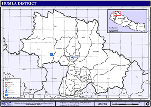
Humla District
| Humla हुम्ला जिल्ला | |
|---|---|
| District | |
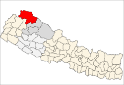 Location of Humla | |
| Country | Nepal |
| Region | Mid-Western (Madhya Pashchimanchal) |
| Zone | Karnali |
| Headquarters | Simikot |
| Area | |
| • Total | 5,655 km2 (2,183 sq mi) |
| Population (2011) | |
| • Total | 50,858 |
| • Density | 9.0/km2 (23/sq mi) |
| Time zone | NPT (UTC+5:45) |
| Website | http://www.ddchumla.gov.np/ |
Humla District(Nepali: हुम्ला जिल्ला![]() Listen , a part of Province No. 6, is one of the seventy-five districts of Nepal. The district, with Simikot as its district headquarters, covers an area of 5,655 km² and had a population of 40,595 in 2001; in 2011 the population was 50,858.[1] The Northern part of Humla District is inhabited by Buddhists, originating from Tibet, whereas the South is mostly inhabited by Hindus.
Listen , a part of Province No. 6, is one of the seventy-five districts of Nepal. The district, with Simikot as its district headquarters, covers an area of 5,655 km² and had a population of 40,595 in 2001; in 2011 the population was 50,858.[1] The Northern part of Humla District is inhabited by Buddhists, originating from Tibet, whereas the South is mostly inhabited by Hindus.
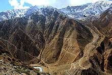
Geography and Climate
| Climate Zone[2] | Elevation Range | % of Area |
|---|---|---|
| Subtropical | 1,000 to 2,000 meters 3,300 to 6,600 ft. |
2.3% |
| Temperate | 2,000 to 3,000 meters 6,400 to 9,800 ft. |
8.9% |
| Subalpine | 3,000 to 4,000 meters 9,800 to 13,100 ft. |
19.4% |
| Alpine | 4,000 to 5,000 meters 13,100 to 16,400 ft. |
58.7% |
| Nival | above 5,000 meters | 10.7% |
Village Development Committees (VDC)
Health Care
- Central/regional/zonal hospitals: 0
- District hospitals: 1
- Primary healthcare centres: 0
- Health posts: 10
- Sub-health posts: 16
- Number of doctors: 3
- Number of nurses: 35
Although there is a district hospital as well as primary health care centers, these are not enough for providing health services. The small health centers in many VDCs are often without Auxiliary Health Workers (AHWs), Auxiliary Nurse Midwives (ANMs) and Community Health Workers (CHWs). Many people still believe in Dhami and Jhakri and often resort to local practices before seeking allopathic treatment.
The Nepal Trust [www.nepaltrust.org], which has been working in Humla for over 20 years, was one of the first (I)NGOs in the district to address development (especially healthcare) issues at grass-roots level. PHASE Nepal (http://phasenepal.org/project-areas/humla/) is a non profit organization which coordinates with the District Health Office in Simikot to provide comprehensive primary health services to the communities of Maila and Melchham, two of the most isolated VDCs of the district; as well as the neighboring villages whom also benefit from these services.
The Trust was the only organization allowed to continue its development work throughout the district during the Maoist insurgency; thus remaining one of the most active and transparent organizations in Humla. The Torpa clinic was built by the trust almost 15 years ago to address the immediate and desperate need for health services. To date, the Trust has expanded services throughout the district including (but not limited to) improvements made to the district hospital. Currently, Trust initiatives are related to ante/post natal care and infant mortality reduction programs.
Besides its head office in Kathmandu, the Nepal Trust has its own satellite office and guest house in Simikot HQ, which acts as a social enterprise (the first built in West Nepal) and besides healthcare, is also actively involved in education, renewable energy, heritage preservation, WASH, food security & agriculture, but also sustainable tourism development and income generation.
Nepal Trust has been managing the Great Himalaya Trail Development Program since 2008.
Tourism
Humla lies in the far western. The remote district is the starting point of many adventure trips. Trekking, mountaineering and more. Simikot Airport is the hub to start trekking from here. The trekking route to Tibet also starts from Simikot. Simikot trek is famous trekking for wilderness experience. The district is the border of Nepal and China.

Trekking
The Nepal section of The Great Himalaya Trail ends in Humla at Hilsa at the border with Tibet. The Humla district an important part of ancient Buddhist religions and it holds a lot of histories, cultures and values of a typical Buddhist life. With more than 10 small villages of Tibetan origin, Humla district is a very important and beautiful part of land not only for the Buddhist all around the world, but also for everyone who wants to learn about buddhist life and study the histories and cultures. The Nyin Community and the Limi Valley are inhabited by peaceful buddhist communities and they are blessed with very beautiful nature, with abundance of natural resources, varied flora and fauna, lots of mountain springs and very clean rivers and beautiful mountains and glacial lakes.
The border crossing at Hilsa is a main entry point for treks going to and coming from Mount Kailash. The normal route to this point is via a 4-5 day walk to Simikot.
See also
References
- ↑ "National Population and Housing Census 2011(National Report)" (PDF). Central Bureau of Statistics. Government of Nepal. November 2012. Archived from the original (PDF) on April 18, 2013. Retrieved November 2012. Check date values in:
|access-date=(help) - ↑ The Map of Potential Vegetation of Nepal - a forestry/agroecological/biodiversity classification system (PDF), . Forest & Landscape Development and Environment Series 2-2005 and CFC-TIS Document Series No.110., 2005, ISBN 87-7903-210-9, retrieved Nov 22, 2013 horizontal tab character in
|series=at position 91 (help)
External links
Coordinates: 29°58′N 81°50′E / 29.967°N 81.833°E
| Wikimedia Commons has media related to Humla District. |