Huari Province
| Huari | ||
|---|---|---|
| Province | ||
|
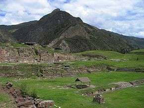
The UNESCO World Heritage Site of Chavín de Huantar | ||
| ||
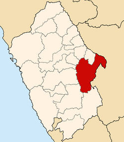 Location of Huari in the Ancash Region | ||
| Country | Peru | |
| Region | Ancash | |
| Capital | Huari | |
| Government | ||
| • Mayor | Edwards Delfio Vizcarra Zorrilla | |
| Area | ||
| • Total | 2,771.9 km2 (1,070.2 sq mi) | |
| Elevation | 3,149 m (10,331 ft) | |
| Population | ||
| • Total | 59,301 | |
| • Density | 21/km2 (55/sq mi) | |
| Website | www.munihuari.gob.pe | |

The Huari Province is one of twenty provinces of the Ancash Region in Peru. Its seat is Huari.
Geography
The Cordillera Blanca traverses the western part of the province. Some of the highest peaks of the province are Rurichinchay and Wantsan. Other mountains are listed below:[1]
- Anku
- Artisa
- Awaq Wank'a
- Awki
- Chunta
- Hatun Chakra
- Hatun Hirka
- Hatun Wak'a
- Hatun Yanaqa Hirka
- Ichik Challwa
- Ichik Chakra
- Kayish
- Kinwa Hirka
- Kiswar Qaqa
- Kunkush
- Kuntur Tuqllana
- Kuntur Wank'a
- Khuchi Mach'ay
- Map'arahu
- Mata Qaqa
- Millwa Pilluy
- Millu Hirka
- Mullu Punta
- Mururahu
- Pamparahu
- Puka Mach'ay
- Pukarahu (Bol.-Huari)
- Pukarahu (Huari)
- Pukyu
- Puma Wayin
- Purway Kinwa
- Putaqa Hirka
- Puywan
- Phiruru
- P'unqu Chakayuq
- Qaqa Mach'ay
- Qaqa Wasi
- Qaqapampa
- Qarwakancha
- Qawish
- Qishqi
- Qiwlla
- Quchapata
- Quri Lanki
- Rima Rima
- Runtuy
- Ruriq
- Shawanka Punta
- Tampu
- Tarush Wachanan
- Tuku
- Tullparahu
- Tuqtu
- Urwashrahu
- Usnu
- Ututu Punta
- Walla Kancha
- Waman Wayi
- Wank'a Punta
- Waraqayuq
- Yana Qaqa
- Yanamaray
- Yanarahu
- Yanaqucha
- Yuraq Wank'a
- Yuraq Yaku
Political division
Huari is divided into sixteen districts, which are:
| DISTRICT | MAYOR |
|---|---|
| Anra | Francisco Santiago Bazan |
| Cajay | Elias Morales Mendoza |
| Chavín de Huantar | Justino Zenon Montes Colcas |
| Huacachi | Filoter Americo Montalvo Espinoza |
| Huacchis | Serafin Perez Remigio |
| Huachis | Epifanio Rios Ocaña |
| Huantar | Renan Wilfredo Trejo Garcia |
| Huari | Edwards Delfio Vizcarra Zorrilla |
| Masin | N |
| Paucas | Robert Pompeo Benites Meza |
| Ponto | Hector Anibal Quiñones Ortega |
| Rahuapampa | Pedro Quispe Huallpa |
| Rapayan | Berino Olortegui Urbano |
| San Marcos | Felix Melecio Solorzano Leyva |
| San Pedro de Chana | Juvenil Pompeyo Villajuan Collazos |
| Uco | Teodoro Tarazona Principe |
Ethnic groups
The people in the province are mainly indigenous citizens of Quechua descent. Quechua is the language which the majority of the population (78.05%) learnt to speak in childhood, 21.49% of the residents started speaking using the Spanish language (2007 Peru Census).[2]
Archaeological sites
The UNESCO World Heritage Site of Chavín de Huantar is the most famous archaeological site of the province.[3] Another remarkable place with cave paintings and stone tombs (chullpa) is Markahirka.
See also
- Allpaqucha
- Challwaqucha
- Hatun Qaqaqucha and Ichik Qaqaqucha
- Yanaqucha
References
- ↑ escale.minedu.gob.pe - UGEL map of the Huari Province (Ancash Region)
- ↑ inei.gob.pe INEI, Peru, Censos Nacionales 2007
- ↑ (Spanish) Official web site of the Huari Province
External links
(Spanish) Official web site of the Huari Province
| |
|---|---|
Coordinates: 9°22′08″S 77°14′13″W / 9.36889°S 77.23694°W