Hualien City
| Hualien 花蓮市 | |
|---|---|
| County-controlled city | |
| Hualien City | |
|
Hualien City | |
| Nickname(s): Huashi (花市) | |
 Hualien City | |
 Hualien Location in Taiwan | |
| Coordinates: 23°58′20″N 121°36′23″E / 23.97222°N 121.60639°ECoordinates: 23°58′20″N 121°36′23″E / 23.97222°N 121.60639°E | |
| Country | Taiwan |
| County | Hualien County |
| Government | |
| • Type | County-controlled city |
| • Mayor | Wei Chia-hsien (KMT)[1] |
| Area | |
| • Total | 29.41 km2 (11.36 sq mi) |
| Population (December 2014) | |
| • Total | 106,368 |
| Time zone | CST (UTC+8) |
| Post code | 970 |
| Subdivision | 45 Boroughs[2] |
| Website |
www |

| Hualien City | |||||||||||||
| Traditional Chinese | 花蓮市 | ||||||||||||
|---|---|---|---|---|---|---|---|---|---|---|---|---|---|
| Simplified Chinese | 花莲市 | ||||||||||||
| |||||||||||||
Hualien City (Chinese: 花蓮市; pinyin: Huālián Shì), is a county-controlled city and the county seat of Hualien County, Taiwan. It is located on the east coast of Taiwan on the Pacific Ocean, and has a population of 106,368 inhabitants.[3]
Name
Hualien County annals (花蓮縣志) record that the city was called "Kiray" (Chinese: 奇萊; Pe̍h-ōe-jī: Kî-lâi) until the early twentieth century. This name refers to the Sakiraya Taiwanese aborigines and their settlement.[4]
After Taiwan came under Japanese rule in 1895 its governors sought to change the name because "Kiray" is pronounced the same as the Japanese word for "dislike" (嫌い kirai). The name was eventually changed to Karen Harbour (Japanese: 花蓮港 Hepburn: Karenkō). After World War II the incoming Kuomintang-led Republic of China retained the Kanji spelling but shortened the name to just Karen (花蓮), or Hualien via Chinese romanization.
History
The Spaniards built mines for gold in Hualien in 1622. Permanent settlements began in 1851, when 2,200 Han Chinese farmers led by Huang A-fong (黃阿鳳) from Taipei arrived at Fengchuan (now the area near Hualien Rear Station). In 1875, more farmers, led by Lin Cang-an (林蒼安) from Yilan, settled at Fengchuan.
Empire of Japan
Settlements in the area remained small by the start of Japanese rule. The city was expanded circa 1912 by its Japanese governors to incorporate Guohua (國華) and Guoan (國安) Villages, a region later known as Old New Port (舊新港街). In 1920, Karenkō Town (花蓮港街) was established, and around 1923 it was extended to Riran Port (鯉浪港), today known as "New Port" (新港),[5] including the Guowei and Guoji Villages. In 1940, the town was upgraded to Karenkō City, Karenkō Prefecture.
Republic of China
On 25 October 1945, Taiwan was handed over from Japan to the Republic of China under Kuomintang government. In January 1946, the incoming Kuomintang designated Hualien City (花蓮市) a county-controlled city of Hualien County and to be the county seat, an administrative structure that has remained in place since Taiwan's transition to democracy (1990-1996).
Subdivisions

The 45 villages (里) of the city are divided into six village unions (聯合里): (in Hanyu Pinyin)
- The first union: Minyun (民運), Minle (民樂), Minxiang (民享), Minyi (民意), Minxin (民心), Minli (民立), Minle (民德), Minzheng (民政), Minqin (民勤), Minxiao (民孝)
- The second union: Minsheng (民生), Minquan (民權), Minzu (民族), Minyou (民有), Minzhu (民主), Minzhi (民治)
- The third union: Zhuji (主計), Zhuyi (主義), Zhuxin (主信), Zhuqin (主勤), Zhushang (主商), Zhugong (主工)
- The fourth union: Zhuxue (主學), Zhuquan (主權), Zhunong (主農), Zhuhe (主和), Zhuli (主力), Zhu'an (主安), Zhumu (主睦)
- The fifth union: Guofeng (國風), Guofang (國防), Guozhi (國治), Guoguang (國光), Guohun (國魂), Guo'an (國安), Guowei (國威), Guohua (國華), Guolian (國聯), Guosheng (國盛)
- The sixth union: Guofu (國富), Guoyu (國裕), Guoqing (國慶), Guoqiang (國強), Guofu (國福), Guoxing (國興)
The newest villages from 2002 are Guosheng, Guoxing, Minxiao, and Minzhu.
Government institutions
Demographics
Hualien City has 9,000 aboriginal people, making it the city with the largest aboriginal population in Taiwan. The majority of the aborigines that reside in Hualien include the Ami, Atayal, and Bunun.[6] Hualien City is also the most densely populated area in Hualien county.[3]
Climate
Hualien has a Koppen tropical rainforest climate that borders on a humid subtropical climate 。
Summer temperature: 25–32 °C (77–90 °F)
Winter temperature: 15–22 °C (59–72 °F)
Average annual temperature: 24 °C (75 °F)
Average Precipitation: approximately 2000 mm
Typhoon Season: June to September, sometimes in May and October.
| Climate data for Hualien | |||||||||||||
|---|---|---|---|---|---|---|---|---|---|---|---|---|---|
| Month | Jan | Feb | Mar | Apr | May | Jun | Jul | Aug | Sep | Oct | Nov | Dec | Year |
| Average high °C (°F) | 21.1 (70.0) |
21.5 (70.7) |
23.4 (74.1) |
26 (78.8) |
28.5 (83.3) |
30.4 (86.7) |
32 (89.6) |
32 (89.6) |
30.4 (86.7) |
28.2 (82.8) |
25.4 (77.7) |
22.5 (72.5) |
26.78 (80.21) |
| Daily mean °C (°F) | 18.0 (64.4) |
18.4 (65.1) |
20.2 (68.4) |
22.7 (72.9) |
25.1 (77.2) |
27.1 (80.8) |
28.5 (83.3) |
28.2 (82.8) |
26.8 (80.2) |
24.8 (76.6) |
22.2 (72) |
19.3 (66.7) |
23.44 (74.2) |
| Average low °C (°F) | 15.4 (59.7) |
15.9 (60.6) |
17.5 (63.5) |
20 (68) |
22.4 (72.3) |
24.3 (75.7) |
25.4 (77.7) |
25.2 (77.4) |
24 (75.2) |
22 (71.6) |
19.5 (67.1) |
16.7 (62.1) |
20.69 (69.24) |
| Average precipitation mm (inches) | 71.91 (2.831) |
99.9 (3.933) |
86.59 (3.409) |
96.09 (3.783) |
195 (7.677) |
219.61 (8.646) |
177.3 (6.98) |
260.6 (10.26) |
344.3 (13.555) |
367.41 (14.465) |
170.61 (6.717) |
67.69 (2.665) |
2,156.99 (84.921) |
| Source: Weatherbase [7] | |||||||||||||
Education

There are 3 universities, 12 senior high schools, 4 junior high schools, 16 elementary schools, 37 churches and 31 temples.
- National Dong Hwa University, Meilun campus
- Tzu Chi University
- Tzu Chi University of Science and Technology
Industries
Hualien City is the center of politics, economy and transportation of Hualien County. Hualien City is the center of import and export trading due to its strategic location within the county and its proximity to airport and major harbor. It also has rich tourism industries, ranging from tourist objects, accommodations etc. One of its ingenious industry is the local stone art cultural industry.
Medical care
- Hualien Tzu Chi Medical Center (First Medical Center in Eastern Taiwan)
- Mennonite Christian Hospital
- Hualien Hospital, Department of Health, Execusive Yuan
Tourist attractions
- Hualien Baseball Stadium
- Hualien County Stone Sculptural Museum
- Hualien Martyrs' Shrine
- Pine Garden
- North Beach Park (Beibing Park)
- South Beach Park and Night Market (Nanbing Park)
- Tzu Chiang Night Market
- Meilun Mountain Park
- Hualien Fish Market
- Old Railroad Cultural Shopping Street
- Rock Street
- Ciji Sing Ji Hall (Meditation Hall) of the Tzu Chi Foundation
Transportation

Air
Hualien City is served by Hualien Airport located at the neighboring Xincheng Township of Hualien County. The airport is about 10 minutes drive to the city.
Rail
Sea
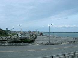
The Port of Hualien is an international port in the city with liners sailing to Japan, Middle East, South East Asia and South Korea.
Road
- Provincial Highway No. 9
- Provincial Highway No. 11
- County Road No.193
Notable natives
- Yeh Kuang-shih, Minister of Transportation and Communications
- Yang Mu, Poet, Writer
Gallery
 Martyrs' shrine in Hualien
 Formosa Express tourist train
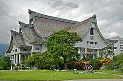 Still Thought's Hall (Jingsi Hall) of Tzu chi Foundation
 Residential community
 Yuan Yeh Resort
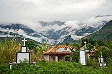 Roadside cemetery
 Hualien County Council
Sister cities
-
 Ulsan, South Korea (1982)
 -
 Yonaguni, Okinawa, Japan (1982)
 -
 Albuquerque, New Mexico, United States (1983)
 - Bellevue, Washington, United States (1984)
-
 Oudtshoorn, South Africa (1985)
 - Takachiho, Miyazaki, Japan (2005)
-
 Santa Maria, Laguna, Philippines (2006)
 - Saipan, Northern Mariana Islands, United States (2007)
-
 Kashipur, Uttarakhand, India (2016)
See also
References
- ↑ "KMT's Wei wins Hualien by-election - Taipei Times".
- ↑ "花蓮市公所-英文版-".
- 1 2 "花蓮市公所-英文版-".
- ↑ 撒奇萊雅族_認識本族. TAIWAN INDIGENOUS PEOPLES CULTURE PARK (in Chinese). Retrieved 3 December 2014.
- ↑ 台灣旅遊景點地圖 - 花蓮縣花蓮市旅遊景點介紹. 旅遊資訊王TravelKing. Retrieved 17 June 2016.
- ↑ Stanisław Kałużyński, ed. (1996). Przegląd orientalistyczny. Warszawa: Polskie Towarzystwo Oreintalistyczne. 177-184: 202. ISSN 0033-2283. Missing or empty
|title=(help) - ↑ "Weatherbase: Historical Weather for Hualien, Taiwan". Weatherbase. 2011. Retrieved on November 24, 2011.
External links
| Wikimedia Commons has media related to Hualien City. |
-
 Hualien travel guide from Wikivoyage
 - Hualien City Office Website (Chinese)
- Web preferential Hualien B & B (Chinese)
Cities and townships of Hualien County | ||
|---|---|---|
| Cities |  | |
| Urban townships | ||
| Rural townships | ||
| Mountain indigenous townships | ||
Taiwanese aboriginal areas | ||||||||||||||||||||||||||||||||||||||||||||||||
|---|---|---|---|---|---|---|---|---|---|---|---|---|---|---|---|---|---|---|---|---|---|---|---|---|---|---|---|---|---|---|---|---|---|---|---|---|---|---|---|---|---|---|---|---|---|---|---|---|
| Highland aboriginal Townships and Districts |
|  | ||||||||||||||||||||||||||||||||||||||||||||||
| Plains aboriginal Townships and County-Controlled Cities |
| |||||||||||||||||||||||||||||||||||||||||||||||
Note: On the map, "Highland aboriginal areas" are in green, and "Plains aboriginal areas" are in tan. | ||||||||||||||||||||||||||||||||||||||||||||||||