Hot Springs, Arkansas
| Hot Springs | |
|---|---|
| City | |
| City of Hot Springs | |
|
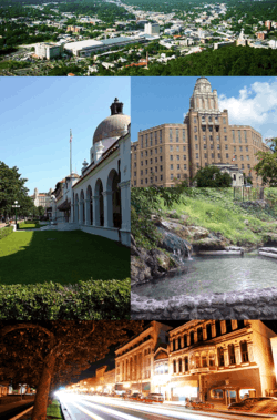
Clockwise from top: Aerial view of Hot Springs, Army-Navy Hospital, a pool of hot spring water in Hot Springs National Park, the Central Avenue Historic District, Bathhouse Row | |
| Nickname(s): Valley of the Vapors | |
| Motto: "America's First Resort"[1] | |
 Location in Garland County and the state of Arkansas | |
| Coordinates: 34°29′50″N 93°3′19″W / 34.49722°N 93.05528°WCoordinates: 34°29′50″N 93°3′19″W / 34.49722°N 93.05528°W | |
| Country |
|
| State |
|
| County | Garland |
| Government | |
| • Type | Council-manager |
| • Mayor | Ruth Carney |
| Area | |
| • City | 91.0 km2 (35.1 sq mi) |
| • Land | 90.7 km2 (35.0 sq mi) |
| • Water | 0.3 km2 (0.1 sq mi) |
| Elevation | 182 m (597 ft) |
| Population (2010) | |
| • City | 35,193 |
| • Estimate (2015) | 35,635 |
| • Density | 392.9/km2 (1,018/sq mi) |
| • Metro | 96,024 |
| Time zone | Central (CST) (UTC-6) |
| • Summer (DST) | CDT (UTC-5) |
| ZIP code | 71901-03, 71913-14 |
| Area code(s) | 501 |
| FIPS code | 05-33400 |
| GNIS feature ID | 0077237 |
| Website |
cityhs |
Hot Springs is the eleventh-largest city in the state of Arkansas and the county seat of Garland County. The city is located in the Ouachita Mountains among the U.S. Interior Highlands, and is set among several natural hot springs for which the city is named. As of the 2010 United States Census, the city had a population of 35,193.[2] In 2015 the estimated population was 35,635.[3]
The center of Hot Springs is the oldest federal reserve in the United States, today preserved as Hot Springs National Park. The hot spring water has been popularly believed for centuries to possess medicinal properties, and was a subject of legend among several Native American tribes. Following federal protection in 1832, the city developed into a successful spa town. Incorporated January 10, 1851, the city has been home to Major League Baseball spring training, illegal gambling, speakeasies and gangsters such as Al Capone, horse racing at Oaklawn Park, the Army and Navy Hospital, and 42nd President Bill Clinton. One of the largest Pentecostal denominations in the United States, the Assemblies of God, traces its beginnings to Hot Springs.
Today, much of Hot Springs's history is preserved by various government entities. Hot Springs National Park is maintained by the National Park Service, including Bathhouse Row, which preserves the eight historic bathhouse buildings and gardens along Central Avenue. Downtown Hot Springs is preserved as the Central Avenue Historic District, listed on the National Register of Historic Places. The city also contains dozens of historic hotels and motor courts, built during the Great Depression in the Art Deco style. Due to the popularity of the thermal waters, Hot Springs benefited from rapid growth during a period when many cities saw a sharp decline in building; much like Miami's art deco districts. As a result, Hot Springs's architecture is a key part of the city's blend of cultures, including a reputation as a tourist town and a Southern city. Also a destination for the arts, Hot Springs features the Hot Springs Music Festival, Hot Springs Documentary Film Festival, and the Valley of the Vapors Independent Music Festival annually.
History

Discovery and settlement
Members of many Native American tribes had been gathering in the valley for untold numbers of years to enjoy the healing properties of the thermal springs.
In 1673, Father Marquette and Jolliet explored the area and claimed it for France. The 1763 Treaty of Paris ceded the land to Spain; however, in 1800 control was returned to France until the Louisiana Purchase of 1803.
In December 1804, Dr. George Hunter and William Dunbar made an expedition to the springs, finding a lone log cabin and a few rudimentary shelters used by people visiting the springs for their healing properties. In 1807, a man named Prudhomme became the first settler of modern Hot Springs, and he was soon joined by John Perciful and Isaac Cates.
On August 24, 1818, the Quapaw Indians ceded the land around the hot springs to the United States in a treaty. After Arkansas became its own territory in 1819, the Arkansas Territorial Legislature requested in 1820 that the springs and adjoining mountains be set aside as a federal reservation. Twelve years later, in 1832, the Hot Springs Reservation was created by the United States Congress, granting federal protection of the thermal waters. The reservation was renamed Hot Springs National Park in 1921.
Civil War
The outbreak of the American Civil War left Hot Springs with a declining bathing population. After the Confederate forces suffered defeat in the Battle of Pea Ridge in March 1862, the Union troops advanced toward the Confederate city of Little Rock. Confederate Governor Henry M. Rector moved his staff and state records to Hot Springs. Union forces did not attack Little Rock, and the government returned to the capital city on July 14, 1862.
Many residents of Hot Springs fled to Texas or Louisiana and remained there until the end of the war. In September 1863, Union forces occupied Little Rock. During this period, Hot Springs became the prey of guerrilla bands loosely associated with either Union or Confederate forces. They pillaged and burned the near-deserted town, leaving only a few buildings standing at the end of the Civil War.[4]
Rebuilding
After the Civil War, an extensive rebuilding of bathhouses and hotels took place at Hot Springs. The year-round population soared to 1,200 inhabitants by 1870. By 1873 six bathhouses and 24 hotels and boardinghouses stood near the springs. In 1874, Joseph Reynolds announced his decision to construct a narrow-gauge railroad from Malvern to Hot Springs; completion in 1875 resulted in the growth of visitation to the springs. Samuel W. Fordyce and two other entrepreneurs financed the construction of the first luxury hotel in the area, the first Arlington Hotel, which opened in 1875.[4]
During the Reconstruction Era, several conflicting land claims reached the U.S. Congress and resulted in an April 24, 1876, Supreme Court ruling that the land title of Hot Springs belonged to the federal government. Protests ensued. To deal with the situation, Congress formed the Hot Springs Commission to lay out streets in the town of Hot Springs, deal with land claims, define property lines, condemn buildings illegally on the permanent reservation (now the national park) and define a process for claimants to purchase land. The commission surveyed and set aside 264.93 acres (1.0721 km2) encompassing the hot springs and Hot Springs Mountain to be a permanent government reservation. Another 1,200 acres (4.9 km2) became the Hot Springs townsite, with 700 acres (2.8 km2) awarded to claimants. The townsite consisted of 196 blocks and 50 miles (80 km) of streets and alleys. The remaining portion of the original four sections of government land consisted of hills and mountains which were mostly unoccupied, and Congress acted on the commission's recommendation in June 1880 by adding those lands to the permanent reservation.[4]
Baseball in Hot Springs
Hot Springs has a rich baseball history. During the early 20th century (1894–1925), Hot Springs was known for baseball training camps after the construction of Whittington Park in 1894. Many Major League clubs brought their teams to Hot Springs to get the players in shape for the coming season. The Cleveland Spiders, Pittsburgh Pirates, Brooklyn Dodgers, Chicago Cubs, Cincinnati Reds, Detroit Tigers, New York Yankees and Boston Red Sox were among the teams that made Hot Springs their home base. It is documented that well over 100 members of the Major League Baseball Hall of Fame trained in Hot Springs. Legendary Babe Ruth once hit a 578-foot home run that landed in the Arkansas Alligator Farm and Petting Zoo, and he could be seen walking the streets, visiting the bath spas, and gambling at the nearby horse track.[5]
Today there are 26 markers posted throughout Hot Springs on the "Hot Springs Baseball Historic Trail" that identify key people and locations.[6]
1913 fire
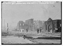
On September 6, 1913, a fire broke out on Church Street a few blocks southeast of Bathhouse Row, near the Army and Navy Hospital. The fire burned southeast, away from the hospital, until the wind reversed an hour later. Racing toward the business section, it destroyed the Ozark Sanitarium and the high school on its way across Malvern Avenue. Along the way it consumed the Public Utilities plant, which destroyed the firefighters' water supply. A wide front then was blown toward Ouachita Avenue which destroyed the Garland County Court House. The Hot Springs Fire Department fought alongside the Little Rock Fire Department, which had rushed over on a special train. Despite their efforts, numerous homes, at least a hundred businesses, four hotels, the Iron Mountain Railroad facilities, and the Crystal Theater were destroyed. A rainstorm finally quenched the blaze at Hazel Street. Although Central Avenue was ultimately protected (primarily by desperate use of dynamite), much of the southern part of the city was destroyed. Damage was estimated at $10,000,000 across 60 blocks.[7][8]
Formation of the Assemblies of God
From April 2–12, 1914 several Pentecostal Christian leaders gathered in Hot Springs to form what became known as the Assemblies of God. It has since grown to become one of the largest Pentecostal denominations in the United States, with 3,146,741 adherents, 12,849 churches, and 36,884 ministers (as of 2014).[9]
Gangsters and illegal gambling

Illegal gambling became firmly established in Hot Springs during the decades following the Civil War, with two factions, the Flynns and the Dorans, fighting one another throughout the 1880s for control of the town. Frank Flynn, leader of the Flynn Faction, had effectively begun paying local law enforcement officers employed by both the Hot Springs Police Department and the Garland County Sheriff's Office to collect unpaid debts, as well as to intimidate gambling rivals. This contributed to the March 16, 1899, Hot Springs Gunfight. Of the seven Hot Springs police officers that have been killed while in service of the department, three died during that gunfight, killed by deputies of the Garland County Sheriff's Office. One part-time deputy sheriff was killed also, by the Hot Springs officers.
Along with Bathhouse Row, one of downtown Hot Springs' most noted landmarks is the Arlington Hotel, a favored retreat for Al Capone.
Hot Springs eventually became a national gambling mecca, led by Owney Madden and his Hotel Arkansas casino. The period 1927–1947 was its wagering pinnacle, with no fewer than ten major casinos and numerous smaller houses running wide open, the largest such operation in the United States at the time. Hotels advertised the availability of prostitutes, and off-track booking was available for virtually any horse race in North America.
Local law enforcement was controlled by a political machine run by long-serving mayor Leo P. McLaughlin. The McLaughlin organization purchased hundreds of poll tax receipts, many in the names of deceased or fictitious persons, which would sometimes be voted in different precincts. A former sheriff, who attempted to have the state's anti-gambling laws enforced and to secure honest elections, was murdered in 1937. No one was ever charged with his killing. Machine domination of city and county government was abruptly ended in 1946 with the election of a "Government Improvement" slate of returning World War II veterans led by Marine Lt. Col. Sid McMath, who was elected prosecuting attorney. A 1947 grand jury indicted several owners and promoters, as well as McLaughlin, for public servant bribery. Although the former mayor and most of the others were acquitted, the machine's power was broken and gambling came to a halt, as McMath led a statewide "GI Revolt" into the governor's office in 1948. Illegal casino gambling resumed, however, with the election of Orval Faubus as governor in 1954. Buoyed into 12 years in office by his popular defiance of federal court desegregation orders, Faubus turned a blind eye to gambling in Hot Springs.[10]
Gambling was finally closed down permanently in 1967 by two Republican officeholders, Governor Winthrop Rockefeller and Circuit Judge Henry M. Britt. Rockefeller sent in a company of state troopers to shutter the casinos and burn their gaming equipment. Until other forms of gambling became legal in Arkansas four decades later,[11] Oaklawn Park, a thoroughbred horse racing track south of downtown, was the only legal gambling establishment in Hot Springs and one of only two in the state of Arkansas; the other was the Southland Greyhound Park dog track in West Memphis. Both Oaklawn and Southland remain in operation.[12]
World War II
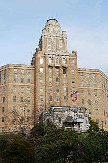
The military took over the enormous Eastman Hotel across the street from the Army and Navy Hospital in 1942 because the hospital was not nearly large enough to hold the sick and wounded coming in. In 1944, the Army began redeploying returning overseas soldiers; officials inspected hotels in 20 cities before selecting Hot Springs as a redistribution center for returning soldiers. In August 1944 the Army took over most of the hotels in Hot Springs. The soldiers from the west-central states received a 21-day furlough before reporting to the redistribution station. They spent 14 days updating their military records and obtaining physical and dental treatment. The soldiers had time to enjoy the baths at a reduced rate and other recreational activities. The redistribution center closed down in December 1945 after processing more than 32,000 members of the military. In 1946, after the war, the Eastman was demolished when the federal government no longer needed it.[4]
21st century
In 2013, the metro was ranked by Forbes as one of the top "small places for business and careers", citing a low cost of doing business, high job growth and an educated workforce.[13]
Geography
.jpg)
Hot Springs is located in southeastern Garland County at 34°29′50″N 93°03′19″W / 34.497138°N 93.055393°W.[14] It sits at the southeastern edge of the Ouachita Mountains and is 55 miles (89 km) southwest of Little Rock.
According to the United States Census Bureau, the city of Hot Springs has a total area of 35.1 square miles (91.0 km2), of which 35.0 square miles (90.7 km2) is land and 0.1 square miles (0.3 km2), or 0.35%, is water.[2]
Natural springs
The city takes its name from the natural thermal water that flows from 47 springs on the western slope of Hot Springs Mountain in the historic downtown district of the city. About 1,000,000 US gallons (3,800,000 L) of 143 °F (62 °C) flow from the springs each day.[15] The flow rate is not affected by fluctuations in the rainfall in the area. Studies by National Park Service scientists have determined through radiocarbon dating that the water that reaches the surface in Hot Springs fell as rainfall 4,400 years earlier.[16] The water percolates very slowly down through the earth's surface until it reaches superheated areas deep in the crust and then rushes rapidly to the surface to emerge from the 47 hot springs.
Hot Springs Creek flows from Whittington Avenue, then is underground in a tunnel beneath Bathhouse Row (Central Ave). It emerges from the tunnel south of Bathhouse Row then flows through the southern part of the city before emptying into Lake Hamilton, a reservoir on the Ouachita River.
Climate
Hot Springs lies in the humid subtropical climate zone (Köppen Cfa). The climate in this area is characterized by hot, humid summers and generally mild to cool winters. July and August are the hottest months of the year, with an average high of 93 °F (34 °C) and an average low of 70.5 °F (21.4 °C). The city's highest temperature was 115 °F (46.1 °C), recorded in 1986. The lowest temperature recorded was −5 °F (−20.6 °C), in 1989
Precipitation is weakly seasonal, with a bimodal pattern: wet seasons in the spring and fall, and relatively drier summers and winters, but some rain in all months. The spring wet season is more pronounced than fall, with the highest rainfall in May. Hot Springs precipitation is impacted by the orographic effect of the Ouachita Mountains.
| Climate data for Hot Springs, Arkansas (1981–2010 normals) | |||||||||||||
|---|---|---|---|---|---|---|---|---|---|---|---|---|---|
| Month | Jan | Feb | Mar | Apr | May | Jun | Jul | Aug | Sep | Oct | Nov | Dec | Year |
| Record high °F (°C) | 81 (27) |
87 (31) |
90 (32) |
97 (36) |
98 (37) |
108 (42) |
114 (46) |
115 (46) |
112 (44) |
99 (37) |
86 (30) |
80 (27) |
115 (46) |
| Average high °F (°C) | 50 (10) |
55 (13) |
64 (18) |
73 (23) |
80 (27) |
88 (31) |
93 (34) |
93 (34) |
86 (30) |
74 (23) |
62 (17) |
52 (11) |
72.5 (22.6) |
| Average low °F (°C) | 31 (−1) |
35 (2) |
42 (6) |
50 (10) |
60 (16) |
67 (19) |
71 (22) |
70 (21) |
63 (17) |
51 (11) |
42 (6) |
33 (1) |
51.3 (10.8) |
| Record low °F (°C) | −1 (−18) |
1 (−17) |
10 (−12) |
24 (−4) |
36 (2) |
49 (9) |
52 (11) |
50 (10) |
37 (3) |
25 (−4) |
14 (−10) |
−5 (−21) |
−5 (−21) |
| Average precipitation inches (mm) | 3.71 (94.2) |
4.45 (113) |
5.15 (130.8) |
5.16 (131.1) |
6.09 (154.7) |
4.40 (111.8) |
4.58 (116.3) |
3.01 (76.5) |
4.09 (103.9) |
5.82 (147.8) |
5.58 (141.7) |
5.30 (134.6) |
57.34 (1,456.4) |
| Source: The Weather Channel[17] | |||||||||||||
Demographics
| Historical population | |||
|---|---|---|---|
| Census | Pop. | %± | |
| 1860 | 201 | — | |
| 1870 | 1,276 | 534.8% | |
| 1880 | 3,554 | 178.5% | |
| 1890 | 8,086 | 127.5% | |
| 1900 | 9,973 | 23.3% | |
| 1910 | 14,434 | 44.7% | |
| 1920 | 11,695 | −19.0% | |
| 1930 | 20,238 | 73.0% | |
| 1940 | 21,370 | 5.6% | |
| 1950 | 29,307 | 37.1% | |
| 1960 | 28,337 | −3.3% | |
| 1970 | 35,631 | 25.7% | |
| 1980 | 35,781 | 0.4% | |
| 1990 | 32,462 | −9.3% | |
| 2000 | 35,750 | 10.1% | |
| 2010 | 35,193 | −1.6% | |
| Est. 2015 | 35,635 | [3] | 1.3% |
Hot Springs is the principal city of the Hot Springs metropolitan area, which includes all of Garland County, registering a population of 96,024 in 2010 according to the United States Census Bureau.
As of the census[19] of 2000, there were 35,750 people, 16,096 households, and 9,062 families residing in the city. The population density was 1,086.9 people per square mile (419.7/km2). There were 18,813 housing units at an average density of 572.0 per square mile (220.8/km2). The racial makeup of the city was 78.86% White, 16.87% Black or African American, 0.55% Native American, 0.79% Asian, 0.05% Pacific Islander, 1.02% from other races, and 1.86% from two or more races. 3.80% of the population were Hispanic or Latino of any race.
There were 16,096 households out of which 22.0% had children under the age of 18 living with them, 40.2% were married couples living together, 12.4% had a female householder with no husband present, and 43.7% are classified as non-families by the United States Census Bureau. Of 16,096 households, 690 are unmarried partner households: 580 heterosexual, 78 same-sex male, and 32 same-sex female. 38.4% of all households were made up of individuals and 18.3% had someone living alone who was 65 years of age or older. The average household size was 2.12 and the average family size was 2.80.
In the city the population was spread out with 20.2% under the age of 18, 8.2% from 18 to 24, 25.4% from 25 to 44, 23.0% from 45 to 64, and 23.2% who were 65 years of age or older. The median age was 42 years. For every 100 females there were 88.4 males. For every 100 females age 18 and over, there were 84.6 males.
The median income for a household in the city was $26,040, and the median income for a family was $32,819. Males had a median income of $25,861 versus $20,155 for females. The per capita income for the city was $17,961. About 13.7% of families and 19.2% of the population were below the poverty line, including 30.7% of those under age 18 and 11.7% of those age 65 or over.
Arts and culture
The city has been a tourist mecca for generations due to the thermal waters and attractions such as Oaklawn Park, a thoroughbred racing facility; Magic Springs and Crystal Falls theme parks; a fine arts community that has earned the city the No. 4 position among "America's Top 100 Small Arts Towns"; the Hot Springs Music Festival; and the Hot Springs Documentary Film Festival, held each October at the historic Malco Theater, attracting numerous Academy Award-winning films and producers.
Annual cultural events
Other annual events in town include the Valley of Vapors Festival, the free Hot Springs Jazz Festival in September,[20] the free Hot Springs Blues Festival in September, the downtown Bathtub Races in the spring, the Big Barbecue Cookoff in spring and fall, the World's Shortest St. Patrick's Day Parade every March 17, and the outdoor skating rink November through January. Venues for live music are Low Key Arts, Maxine's, The Ohio Club, The Big Chill, and the Arlington Hotel among many others.
Superlift Offroad Vehicle Park hosts the annual Ouachita Jeep Jamboree, an off-road adventure weekend that draws people and their 4x4's from a dozen states.
Educational institutes and conventions are important events in the spa city. Perhaps the most popular of these events is the Hot Springs Technology Institute (HSTI), drawing over 1,300 participants each June. Hot Springs is also home to the annual alternate reality game Midnight Madness, based on the movie from which it gets its name. Teams race throughout the city at night, solving clues based on difficult puzzle and physical challenges. Games last 12 hours or more, with the winning team designing the following year's game.
Tourism
Arkansas Alligator Farm and Petting Zoo
Founded on Whittington Avenue in 1902, the Arkansas Alligator Farm and Petting Zoo features approximately 200 alligators.[21][22] The zoo also contains cougars, turkeys, chickens, wild boars, turtles, bobcats,[23] and ring-tailed lemurs.[24] A petting zoo with goats, emus, llamas, white-tailed deer, pigs, baby alligators, and other animals allows visitors to touch and feed the animals. An alligator feeding show includes educational material about the animals.
Bathhouse Row, Hot Springs National Park

Bathhouse Row, consisting of eight turn-of-the century historic buildings, lies within Hot Springs National Park and is managed by the National Park Service. Fordyce Bathhouse was restored in 1989 as the park's visitor center and the beginning of restoring all properties on Bathhouse Row.[25] The series of renovations and leasing public spaces to commercial owners became a model for similar projects across the nation.[26]
Buckstaff Bathhouse has been in continuous operation since 1912 and is one of the best-preserved structures on Bathhouse Row.[27] The Buckstaff Bathhouse Company has completed the majority of maintenance and renovation that has occurred without outside funding.[28] The Quapaw was restored by the NPS in 2004, and the renovated structure was leased to Quapaw Baths, LLC, which now operates a modern spa with pools and hot tubs.[29] The Lamar was renovated into offices for park staff and Bathhouse Row Emporium, the park's official store.[30] The Superior Bathhouse Brewery and Distillery has occupied Superior Bathhouse since 2012, using hot spring water in its beers and spirits.[31] As of February 2014, the Maurice, Ozark, and Hale bathhouses are all available for rent from the NPS.[32]
Atop Hot Springs Mountain in the park is the Hot Springs Mountain Tower, a 216-foot (66 m) observation tower built in 1982.
Central Avenue

Along Bathhouse Row is Central Avenue, Highway 7, lined with historic buildings, businesses and tourist attractions. Today preserved by NRHP as Hot Springs Central Avenue Historic District, the district includes 77 contributing properties to the district between Prospect Street and Park Avenue.[28] Included within this district are the 1924 Arlington Hotel, the Medical Arts Building, a 1929 Art Deco high-rise, and the Wade Building, built in 1927 in the neoclassical style.[28]
Garvan Woodland Gardens
Founded by the daughter of a lumber and brick magnate in 1985, the 210-acre (85 ha) botanical garden on Arkridge Road features native Ouachita Mountains flora among rocky streams and waterfalls. Garvan also has a Japanese-themed section with several species native to Japan throughout. The garden is situated on a peninsula jutting into Lake Hamilton and began as Verna Garvan's personal garden for decades before being donated to the University of Arkansas landscape architecture department.
Historic hotels and districts
Thirteen of Hot Springs' hotels are individually listed by the NRHP within the city, with more being listed as contributing properties within other districts. Four of Hot Springs' neighborhoods are preserved as historic districts by the National Register of Historic Places, and the city also contains five historically important commercial districts in addition to the aforementioned Bathhouse Row and Central Avenue Historic District.
The city contains several historic hotels, including the Arlington Hotel, Jack Tar Hotel and Bathhouse, Mountainaire Hotel Historic District, Park Hotel, and the Riviera Hotel. During Hot Springs' heyday, several tourists visiting the city stayed at motor courts, the precursor to today's hotels. The NRHP recognizes seven of these motels as culturally and historically significant: Bellaire Court Historic District, Cottage Courts Historic District, Cove Tourist Court, George Klein Tourist Court Historic District, Lynwood Tourist Court Historic District, Parkway Courts Historic District, Perry Plaza Court Historic District, and the Taylor Rosamond Motel Historic District.
The Fordyce-Ricks House Historic District at 1501 Park Avenue includes three buildings on 37 acres (15 ha) formerly owned by Samuel W. Fordyce, a prominent businessman and railroad executive who moved to Hot Springs in 1876. The house and outbuildings are built as log cabins in the Adirondack style.[28] The Pleasant Street Historic District along Malvern Avenue (colloquially "Black Broadway") contains 93 contiguous buildings associated with the city's African American community. Included within the district are the Visitors Chapel AME church and the Woodmen of Union Building, along with 69 other contributing structures. A variety of architectural styles are used, with many of the structures using brick facades. The Quapaw-Prospect Historic District contains 233 structures near downtown Hot Springs, with 139 residential houses contributing to the character of the district built between 1890 and 1950 in several architectural styles.[28] The Whittington Park Historic District is a residential district lining Whittington Park, a long, narrow park between two one-way streets created by the National Park Service in 1897. The 1896–1960 district contains 60 single-family houses and ten other structures. Predominantly Craftsman, ranch and Queen Anne-style buildings, the district is northwest of downtown Hot Springs.
Seven districts in Hot Springs have special historical significance to the city's past economy. In addition to the aforementioned Bathhouse Row and Central Avenue Historic District, the Army and Navy General Hospital Historic District includes 31 buildings surrounding and supporting the former Army-Navy Hospital. Built in 1933, the six-story brick building built in the Spanish Colonial Revival style with Art Deco detailing is the centerpiece of the district, and remains the most imposing figure on the Hot Springs skyline. The Forest Service Headquarters Historic District encompasses six structures on Winona and Indiana Streets built by the Civilian Conservation Corps as the headquarters of the Jessieville Ranger District of the Ouachita National Forest. The Hot Springs Railroad Warehouse Historic District preserves three brick buildings between the Missouri Pacific Railroad tracks and Broadway. Almost entirely unaltered, the 1920s structures are associated with the railroad industry, which was extremely important to Hot Springs in the early 20th century. As the city grew during the early 20th century, commercial activity developed along Ouachita Avenue south of Bathhouse Row, today preserved as the Ouachita Avenue Historic District. Mostly consisting of brick commercial and multifamily buildings, the district maintains the character of an historic commercial area. The 1905 Peter Joplin Commercial Block building was the only building to survive the 1913 "Black Friday" fire, making it a remnant of early commercial activity on Ouachita Avenue when all contemporary structures have been destroyed.
Lake Catherine and Lake Hamilton
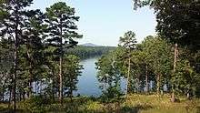
Lake Hamilton and Lake Catherine are two reservoirs of the Ouachita River south of Hot Springs created for hydroelectric power generation and recreational uses. Both created by Arkansas Power & Light (AP&L), Lake Catherine formed following the construction of Remmel Dam in the 1920s. Following a donation of over 2,000 acres (810 ha), the state created Lake Catherine State Park in 1935. Today, the park features fishing and water recreation as well as camping to visitors. Lake Hamilton was created following the construction of Carpenter Dam in the 1930s. Built during the Great Depression, the power produced by the dam is credited with allowing AP&L to survive the difficult economic times. Following construction, resorts, businesses, and homes have been built along the lake, in contrast to Lake Catherine. Due to the economic importance of the dam to Hot Springs, Carpenter Dam was placed on the National Register of Historic Places in 1992.[28] Fishing is popular on Lake Hamilton, and the Arkansas Game and Fish Commission operates a fish hatchery to stock the lake with bass and other species.[33]
Oaklawn Park
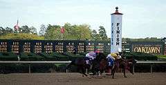
Oaklawn Park has been in operation since 1904. (An additional horse racing park was once within the city limits, but was eventually closed.) The meet, which is annually held from January through mid-April each year, is sometimes referred to as the "Fifth Season" and features the "Racing Festival of the South" during the last week of the racing season each April. Many Triple Crown contenders compete in the Arkansas Derby, which is the big finale each year of the meet. Former U.S. President Bill Clinton, his half-brother Roger, and Billy Bob Thornton, all Hot Springs natives, have been known to frequent Oaklawn Park in the past.
Sister city
Government
Hot Springs operates under the council-manager form of city government, one of the two most common forms of local government in the United States, and common in smaller municipalities. The city is divided into six districts, which elect a city director to the seven-member board of directors. As a body, the board is the prime executive branch of Hot Springs government whose duties include making policy, creating a budget, and passing resolutions and ordinances. The seventh member is a mayor elected at-large by Hot Springs. The mayor presides over city functions in an official capacity and manages the municipal government, without legislative authority. City director elections are held every four years, but are staggered such that elections for three districts coincide with the election of the President of the United States and four occur in November of "off years".[35]
Education
Hot Springs public secondary education includes five school districts, ultimately leading to graduation from five different high schools. The majority of Hot Springs is included in the Hot Springs School District, which leads to graduation from Hot Springs High School. The northern section of the city is within the Fountain Lake School District, leading to graduation from Fountain Lake High School. East of the Hot Springs School District is the Cutter–Morning Star School District, leading to graduation from Cutter–Morning Star High School, and the Lakeside School District, leading to graduation from Lakeside High School is located southeast of town. To the southwest, students are to be enrolled in Lake Hamilton School District, which leads to graduation from Lake Hamilton High School.
The Arkansas School for Mathematics, Sciences, and the Arts (ASMSA), an advanced statewide program within the University of Arkansas System and National Consortium for Specialized Secondary Schools of Mathematics, Science and Technology, is also located in Hot Springs. A two-year residential program, ASMSA was established in 1993 and is available to students from across the state following acceptance. Hot Springs Christian School is the only private provider of K–12 education in Hot Springs. The only accredited post-secondary educational opportunity in Hot Springs is at National Park Community College. Created from a merger between Garland County Community College and Quapaw Technical Institute, the college enrolls approximately 3,000 students annually in credit programs. Champion Baptist College, an unaccredited four-year Christian vocational college associated with Gospel Light Baptist Church, is also located in Hot Springs. Champion Baptist College was issued a Letter of Exemption from Certification by the Arkansas Department of Higher Education to offer church-related courses and grant church-related degrees.
Media
The Hot Springs newspaper is the Sentinel-Record, originally part of the Clyde E. Palmer chain, since renamed WEHCO Media.
The online newspaper is www.HotSpringsDaily.com. It lists up-to-the minute concise information about the city.
The Thrifty Nickel, a classified advertising publication, is published from offices at 670 Ouachita Avenue. The Little Rock edition is also published from this office.
Seven AM radio stations and fifteen FM stations broadcast from the area.
In addition, most of the Little Rock radio stations provide at least secondary coverage of the city.
Hot Springs is part of the Little Rock television market.
Infrastructure
Transportation
Major highways
U.S. Route 70 and U.S. Route 270 bypass the downtown to the south on the four-lane Dr. Martin Luther King Jr. Expressway. U.S. Route 70 Business passes through the center of Hot Springs as Grand Avenue, Summer Street, Albert Pike Road, and Airport Road, while U.S. Route 270 Business enters from the east as Malvern Avenue, joins US 70 Business along Grand Avenue and Summer Street, and exits to the west as Albert Pike Road. US-70 leads east 31 miles (50 km) to Benton and west-southwest 32 miles (51 km) to Glenwood, while US-270 leads southeast 20 miles (32 km) to Malvern and west-northwest 36 miles (58 km) to Mount Ida.
Arkansas Highway 7 passes through the center of Hot Springs as Central Avenue and Park Avenue. It leads north across the Ouachita Mountains 71 miles (114 km) to Russellville on the Arkansas River, and south 35 miles (56 km) to Arkadelphia.
Arkansas Highway 128 (Carpenter Dam Road) branches off US-270 Business in southeastern Hot Springs, leading south 4 miles (6 km) to Red Oak.
Interstate 30 passes to the southeast of Hot Springs, with the closest access 17 miles (27 km) to the southeast via US-270. I-30 can also be reached 24 miles (39 km) to the east via US-70.
Aviation
Hot Springs is served by Hot Springs Memorial Field Airport. Major air transport is available through Little Rock National Airport, approximately 55 miles (89 km) from Hot Springs.
Notable people
- Steve Barton, actor, singer, dancer, choreographer, stage director and teacher
- Bobby Bones, radio personality born in Hot Springs
- Alan Clark, state senator from Garland, Hot Spring, Saline, and Grant counties, businessman in Hot Springs[36]
- Bill Clinton, governor of Arkansas and 42nd President of the United States, boyhood home
- Roger Clinton Jr., musician, actor and half-brother of former US President Bill Clinton, born in Hot Springs on July 25, 1956[37][38]
- Bruce Cozart, developer in Hot Springs, District 24 member of the Arkansas House of Representatives since 2001
- Lynn A. Davis, temporary head of the Arkansas state police during the Winthrop Rockefeller administration, cleared Hot Springs of illegal gambling in 1967
- Gauge, pornographic actress born in Hot Springs
- Cliff Harris, NFL Dallas Cowboys free safety, played quarterback at Hot Springs High School until his senior year, when he moved to Des Arc
- V. E. Howard, Church of Christ minister who founded the International Gospel Hour in Texarkana, Texas; pastor in Hot Springs early in his career[39]
- Q. Byrum Hurst,prominent attorney, member of the Arkansas State Senate from 1950 to 1972 and the Garland County administrative judge from 1947 to 1950
- Alan Ladd, actor born in Hot Springs
- Marjorie Lawrence, Metropolitan Opera diva, resident for many years
- Haven for gangsters in the 1930s, including longtime residents Lucky Luciano and Owney Madden[10]
- The Countess Leon (Elisa Heuser Leon), the widow of Bernhard Müller, a leader of a small 19th century utopian group, spent her last years in Hot Springs, where she died in 1881[40]
- Arch McDonald, baseball broadcaster born in Hot Springs
- Sid McMath, progressive reform governor of Arkansas 1949-1953, trial lawyer, and decorated U.S. Marine general
- Joan Meredith, actress born in Hot Springs
- Bobby Mitchell, NFL Hall of Fame running back born in Hot Springs
- James Rector, born in Hot Springs, won a silver medal at the Olympics and was the first Olympian from Arkansas
- Earl T. Ricks and I. G. Brown, decorated World War II aviators, Hot Springs natives who served as reform mayor and sheriff, respectively (1947–49), before resuming Air Force careers
- Paul Runyan, golfer born in Hot Springs; went on to win two PGA championships and is a member of the World Golf Hall of Fame
- Laurie Rushing, Republican member of the Arkansas House of Representatives from District 26 since 2015; real estate broker
- Bill Sample, Republican member of both houses of the Arkansas General Assembly since 2005; businessman in Hot Springs[41]
- George Luke Smith, who served in the U.S. House from Louisiana's 4th congressional district, relocated to Hot Springs, where he engaged in the real estate business and died in 1884
- Billy Bob Thornton, actor, director and Academy Award-winning screenwriter, born in Hot Springs
See also
References
- ↑ "City of Hot Springs Arkansas". City of Hot Springs Arkansas. Retrieved September 12, 2012.
- 1 2 "Geographic Identifiers: 2010 Demographic Profile Data (G001): Hot Springs city, Arkansas". U.S. Census Bureau, American Factfinder. Retrieved November 10, 2016.
- 1 2 "Annual Estimates of the Resident Population for Incorporated Places: April 1, 2010 to July 1, 2015". Retrieved July 2, 2016.
- 1 2 3 4 Paige, John C; Laura Woulliere Harrison (1987). Out of the Vapors: A Social and Architectural History of Bathhouse Row, Hot Springs National Park (PDF). U.S. Department of the Interior.
- ↑ http://arkbaseball.com/tiki-index.php?page=Professional+Baseball+Ballparks&structure=Professional+Baseball
- ↑ http://www.hotspringsbaseballtrail.com/category/untold-stories/
- ↑ "Hot Springs Again Hit by Fire". The Arkansas News. Old State House Museum. Fall 1984. Archived from the original on 2005-03-17. Retrieved 2008-03-30.
- ↑ "$6,000,000 DAMAGE IN HOT SPRINGS FIRE; Thirty Blocks of Arkansas Resort Swept Away Within a Few Hours.". The New York Times. The New York Times Company. 1913-09-06. Retrieved 2008-03-30.
- ↑ "Brief History of the Assemblies of God". Retrieved 2016-03-22.
- 1 2 The Five Families. MacMillan. Retrieved 2008-06-22.
- ↑ Charitable bingo was authorized by Arkansas Constitution , Amendment 84 effective January 1, 2007. Also, the Arkansas Scholarship Lottery began in 2009 under Amendment 87.
- ↑ Hodge, Michael (2008-01-08). "Oaklawn Park Racetrack". Encyclopedia of Arkansas History and Culture. Butler Center for Arkansas Studies at the Central Arkansas Library System. Retrieved 2013-12-22.
- ↑ "Hot Springs, Arkansas". Best Small Places For Business And Careers. Forbes. Retrieved 2013-12-22.
- ↑ "US Gazetteer files: 2010, 2000, and 1990". United States Census Bureau. 2011-02-12. Retrieved 2011-04-23.
- ↑ Bedinger, M.S.; Pearson Jr., F.J.; Reed, J.E.; Sniegocki, R.T.; Stone, C.G. (1979). "The waters of Hot Springs National Park, Arkansas; their nature and origin" (PDF). Geological Survey Professional Paper 1044-C. Washington D.C.: United States Geological Survey.
- ↑ Kresse, T.M.; Hays, P.D. (February 2011) [First published 2009]. "Geochemistry, comparative analysis, and physical and chemical characteristics of the thermal waters east of Hot Springs National Park, Arkansas" (PDF). Geological Survey Scientific Investigations Report 2009-5263. United States Geological Survey.
- ↑ "Monthly Averages for Hot Springs, AR" (Table). The Weather Channel. Retrieved 2013-12-22.
- ↑ "Census of Population and Housing". Census.gov. Retrieved June 4, 2015.
- ↑ "American FactFinder". United States Census Bureau. Retrieved 2008-01-31.
- ↑ Hot Springs Jazz Fest 2008 - Welcome
- ↑ "Arkansas Alligator Farm & Petting Zoo". Arkansas Alligator Farm & Petting Zoo. Archived from the original on 2011-02-15. Retrieved 8 September 2010.
- ↑ "Alligator Farm Celebrates 105th Birthday". Little Rock, Arkansas: KLRT-TV. February 7, 2007. Archived from the original on February 15, 2011. Retrieved September 9, 2010.
- ↑ "Arkansas Alligator Farm". Little Rock, Arkansas: KLRT-TV. August 1, 2008. Archived from the original on 2008-12-30. Retrieved September 8, 2010.
- ↑ "About Us". Arkansas Alligator Farm & Petting Zoo. Archived from the original on 2011-02-15. Retrieved September 8, 2010.
- ↑ "Fordyce Bathhouse". National Park Service. March 1, 2014. Retrieved March 1, 2014.
- ↑ Clarke, Jay (October 18, 1987). "Hot Springs On Comeback Trail As Renovation Begins on Bathhouses". The Chicago Tribune. Retrieved March 1, 2014.
- ↑ "Buckstaff Bathhouse". National Park Service. March 1, 2014. Retrieved March 1, 2014.
- 1 2 3 4 5 6 National Park Service (2009-03-13). "National Register Information System". National Register of Historic Places. National Park Service.
- ↑ "Return of the Quapaw Bathhouse". National Park Service. March 1, 2014. Retrieved March 1, 2014.
- ↑ "Lamar Bathhouse". National Park Service. March 1, 2014. Retrieved March 1, 2014.
- ↑ "Vapor Valley signs lease with National Park Service". Arkansas Democrat-Gazette. March 8, 2013. Retrieved March 1, 2014.
- ↑ "National Park Service offers Ozark Bathhouse for lease opportunity; new deadline to submit proposal is February. 27". Hot Springs Daily. Retrieved March 1, 2014.
- ↑ Lancaster, Guy. "Carpenter Dam". Encyclopedia of Arkansas History and Culture. Butler Center for Arkansas Studies at Central Arkansas Library System. Retrieved March 1, 2014.
- ↑ http://www.ci.hot-springs.ar.us/residents-sister-city.html
- ↑ "How City Government Works". City of Hot Springs. Retrieved 2013-12-22.
- ↑ "Alan Clark: Get to Know Me". alanclarklistens.com. Retrieved December 6, 2013.
- ↑ "Roger Clinton - IMDb". imdb.com. Retrieved May 3, 2014.
- ↑ Maraniss, David (1994-01-07). "The Woman Who Shaped the President". The Washington Post. Retrieved 2010-03-14.
- ↑ "Verna Elisha Howard (1911-2000)". therestorationmovement.com. Retrieved July 12, 2013.
- ↑ David James, III, "Germantown: Once Thriving and Socialistic", Minden Press, Minden, Louisiana, July 7, 1958, pp. 1-2
- ↑ "Bill Sample's Biography". votesmart.org. Retrieved December 6, 2013.
External links
| Wikivoyage has a travel guide for Hot Springs (Arkansas). |
| Wikimedia Commons has media related to Hot Springs, Arkansas. |
- Official website
- Greater Hot Springs Chamber of Commerce
- History of Hot Springs' Jewish community (from the Institute of Southern Jewish Life)
- Hot Springs Convention and Visitor's Bureau, tourism and vacation information
Municipalities and communities of Garland County, Arkansas, United States | ||
|---|---|---|
| Cities | 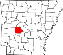 | |
| Towns | ||
| CDPs | ||
| Townships |
| |
| Other unincorporated communities | ||
| Footnotes | ‡This populated place also has portions in an adjacent county or counties | |