Horton, Kansas
| Horton, Kansas | |
|---|---|
| City | |
|
Post Office in Horton (2015) | |
 Location within Brown County and Kansas | |
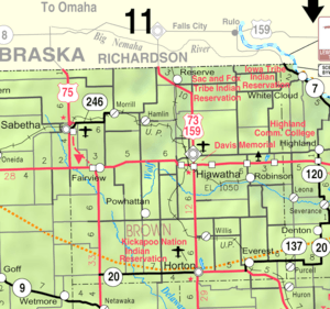 KDOT map of Brown County (legend) | |
| Coordinates: 39°39′50″N 95°31′41″W / 39.66389°N 95.52806°WCoordinates: 39°39′50″N 95°31′41″W / 39.66389°N 95.52806°W | |
| Country | United States |
| State | Kansas |
| County | Brown |
| Area[1] | |
| • Total | 1.80 sq mi (4.66 km2) |
| • Land | 1.78 sq mi (4.61 km2) |
| • Water | 0.02 sq mi (0.05 km2) |
| Elevation | 1,093 ft (333 m) |
| Population (2010)[2] | |
| • Total | 1,776 |
| • Estimate (2012)[3] | 1,751 |
| • Density | 990/sq mi (380/km2) |
| Time zone | Central (CST) (UTC-6) |
| • Summer (DST) | CDT (UTC-5) |
| ZIP code | 66439 |
| Area code(s) | 785, exchange 486 |
| FIPS code | 20-33200 [4] |
| GNIS feature ID | 0473244 [5] |
| Website | HortonKansas.net |

Horton is a city in Brown County, Kansas, United States. As of the 2010 census, the city population was 1,776.[6]
History
Horton was founded in 1886.[7] It was named for Albert H. Horton, chief justice of the Kansas Supreme Court.[8][9][10]
On January 22, 2013, the host of CNBC television show The Profit toured Horton in hopes of revitalizing Horton's downtown business district. Within 18 months, the community started the “Reinvent Horton” campaign to clean up the community and update "run-down" aspects of it, including the installation of curbs, sidewalks, and light poles, razed some buildings, and a large community effort to try to change Horton.[11][12]
Geography
Horton is located at 39°39′50″N 95°31′41″W / 39.66389°N 95.52806°W (39.663817, -95.528130).[13] According to the United States Census Bureau, the city has a total area of 1.80 square miles (4.66 km2), of which, 1.78 square miles (4.61 km2) is land and 0.02 square miles (0.05 km2) is water.[1]
Demographics
| Historical population | |||
|---|---|---|---|
| Census | Pop. | %± | |
| 1890 | 3,316 | — | |
| 1900 | 3,398 | 2.5% | |
| 1910 | 3,600 | 5.9% | |
| 1920 | 4,009 | 11.4% | |
| 1930 | 4,049 | 1.0% | |
| 1940 | 2,872 | −29.1% | |
| 1950 | 2,354 | −18.0% | |
| 1960 | 2,361 | 0.3% | |
| 1970 | 2,177 | −7.8% | |
| 1980 | 2,130 | −2.2% | |
| 1990 | 1,885 | −11.5% | |
| 2000 | 1,967 | 4.4% | |
| 2010 | 1,776 | −9.7% | |
| Est. 2015 | 1,721 | [14] | −3.1% |
| U.S. Decennial Census | |||
2010 census
As of the census[2] of 2010, there were 1,776 people, 732 households, and 453 families residing in the city. The population density was 997.8 inhabitants per square mile (385.3/km2). There were 904 housing units at an average density of 507.9 per square mile (196.1/km2). The racial makeup of the city was 82.5% White, 0.8% African American, 10.7% Native American, 0.5% Asian, 0.8% from other races, and 4.6% from two or more races. Hispanic or Latino of any race were 3.7% of the population.
There were 732 households of which 31.8% had children under the age of 18 living with them, 40.8% were married couples living together, 14.5% had a female householder with no husband present, 6.6% had a male householder with no wife present, and 38.1% were non-families. 34.3% of all households were made up of individuals and 16.7% had someone living alone who was 65 years of age or older. The average household size was 2.38 and the average family size was 3.02.
The median age in the city was 38.3 years. 27.5% of residents were under the age of 18; 8.3% were between the ages of 18 and 24; 21.2% were from 25 to 44; 22.8% were from 45 to 64; and 20.2% were 65 years of age or older. The gender makeup of the city was 48.5% male and 51.5% female.
2000 census
As of the census[4] of 2000, there were 1,967 people, 812 households, and 506 families residing in the city. The population density was 1,125.8 people per square mile (434.0/km²). There were 906 housing units at an average density of 518.5 per square mile (199.9/km²). The racial makeup of the city was 84.65% White, 0.97% African American, 10.78% Native American, 0.66% Asian, 0.51% from other races, and 2.44% from two or more races. Hispanic or Latino of any race were 2.08% of the population.
There were 812 households out of which 29.3% had children under the age of 18 living with them, 47.3% were married couples living together, 11.6% had a female householder with no husband present, and 37.6% were non-families. 34.5% of all households were made up of individuals and 18.8% had someone living alone who was 65 years of age or older. The average household size was 2.35 and the average family size was 3.00.
In the city the population was spread out with 27.5% under the age of 18, 6.7% from 18 to 24, 22.9% from 25 to 44, 20.2% from 45 to 64, and 22.7% who were 65 years of age or older. The median age was 39 years. For every 100 females there were 88.4 males. For every 100 females age 18 and over, there were 84.1 males.
The median income for a household in the city was $22,991, and the median income for a family was $31,447. Males had a median income of $25,000 versus $21,474 for females. The per capita income for the city was $13,063. About 14.0% of families and 17.4% of the population were below the poverty line, including 17.9% of those under age 18 and 18.5% of those age 65 or over.
Geography
Climate
Humid continental climate is a climatic region typified by large seasonal temperature differences, with warm to hot (and often humid) summers and cold (sometimes severely cold) winters. The Köppen Climate Classification subtype for this climate is "Dfa". (Hot Summer Continental Climate).[15]
| Climate data for Horton, Kansas | |||||||||||||
|---|---|---|---|---|---|---|---|---|---|---|---|---|---|
| Month | Jan | Feb | Mar | Apr | May | Jun | Jul | Aug | Sep | Oct | Nov | Dec | Year |
| Average high °C (°F) | 37 (3) |
42 (6) |
53 (12) |
66 (19) |
74 (23) |
84 (29) |
90 (32) |
88 (31) |
80 (27) |
69 (21) |
54 (12) |
40 (4) |
64.8 (18.3) |
| Average low °C (°F) | 16 (−9) |
21 (−6) |
29 (−2) |
41 (5) |
51 (11) |
61 (16) |
66 (19) |
64 (18) |
56 (13) |
44 (7) |
31 (−1) |
20 (−7) |
41.7 (5.3) |
| Average precipitation mm (inches) | 0.9 (23) |
1.1 (28) |
1.9 (48) |
3.0 (76) |
4.6 (117) |
5.3 (135) |
3.7 (94) |
3.9 (99) |
4.1 (104) |
2.3 (58) |
1.5 (38) |
1.0 (25) |
33.3 (846) |
| Source: Weatherbase [16] | |||||||||||||
Education
Notable people
- Boots Adams, businessman
- Robert Harder, Kansas legislator
- Danny J. Petersen, Vietnam War posthumous recipient of the Medal of Honor[17]
References
- 1 2 "US Gazetteer files 2010". United States Census Bureau. Archived from the original on 2012-01-24. Retrieved 2012-07-06.
- 1 2 "American FactFinder". United States Census Bureau. Retrieved 2012-07-06.
- ↑ "Population Estimates". United States Census Bureau. Archived from the original on 2013-06-17. Retrieved 2013-05-29.
- 1 2 "American FactFinder". United States Census Bureau. Archived from the original on 2013-09-11. Retrieved 2008-01-31.
- ↑ "US Board on Geographic Names". United States Geological Survey. 2007-10-25. Retrieved 2008-01-31.
- ↑ "2010 City Population and Housing Occupancy Status". U.S. Census Bureau. Archived from the original on July 21, 2011. Retrieved April 9, 2012.
- ↑ Blackmar, Frank Wilson (1912). Kansas: A Cyclopedia of State History, Embracing Events, Institutions, Industries, Counties, Cities, Towns, Prominent Persons, Etc. Standard Publishing Company. p. 875.
- ↑ Kansas State Historical Society (1916). Biennial Report of the Board of Directors of the Kansas State Historical Society. Kansas State Printing Plant. p. 149.
- ↑ Gannett, Henry (1905). The Origin of Certain Place Names in the United States. Govt. Print. Off. p. 161.
- ↑ "Judge Albert H. Horton". Blue Skyways. Kansas State Library. Retrieved 25 June 2014.
- ↑ Reality TV figure Marcus Lemonis gives a bump to Horton and small KC business; The Kansas City Star; June 21, 2015.
- ↑ Reinvent Horton Town Meeting; Youtube.
- ↑ "US Gazetteer files: 2010, 2000, and 1990". United States Census Bureau. 2011-02-12. Retrieved 2011-04-23.
- ↑ "Annual Estimates of the Resident Population for Incorporated Places: April 1, 2010 to July 1, 2015". Retrieved July 2, 2016.
- ↑ Climate Summary
- ↑ "Weatherbase.com". Weatherbase. 2013. Retrieved on May 28, 2013.
- ↑ "Vietnam War Medal of Honor recipients (M-Z)". Medal of Honor citations. United States Army Center of Military History. October 3, 2003. Retrieved June 5, 2010.
External links
| Wikimedia Commons has media related to Horton, Kansas. |
- City
- Schools
- USD 430, local school district
- Maps
- Horton City Map, KDOT
Municipalities and communities of Brown County, Kansas, United States | ||
|---|---|---|
| Cities | 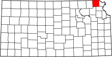 | |
| CDPs | ||
| Unincorporated communities | ||
| Indian reservations | ||
| Townships | ||
| Footnotes | ‡This populated place also has portions in an adjacent county or counties | |