Hornibrook Bridge
| Hornibrook Bridge | |
|---|---|
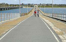 Looking south, Houghton Highway on left, 2005 | |
| Coordinates | 27°16′43″S 153°04′00″E / 27.278748°S 153.066802°ECoordinates: 27°16′43″S 153°04′00″E / 27.278748°S 153.066802°E |
| Carries | trucks, bicycle |
| Crosses | Bramble Bay |
| Locale | Brisbane, Queensland |
| Heritage status | Queensland listed structure |
| Characteristics | |
| Design | Viaduct |
| Material | Wood |
| Total length | 2.684 km |
| Width | 7.92 m[1] |
| Number of spans | 294[1] |
| History | |
| Designer | Sir Manuel Hornibrook |
| Construction begin | 8 June 1932[1] |
| Opened | 14 October 1935[1] |
| Closed | 14 July 2010 |
The Hornibrook Bridge was a privately funded toll bridge, the first of three bridges to cross Bramble Bay, Queensland, Australia. The second is the publicly funded (non tolled) Houghton Highway bridge, which was built with the intention of duplicating the crossing capacity of the two-lane Hornibrook Bridge in the 1970s, but the upgrading of the original Hornibrook Bridge was subsequently found to be uneconomic. The third bridge, the Ted Smout Memorial Bridge opened to traffic in July 2010, delivering the desired capacity increase and resulting in the demolition of the original Hornibrook Bridge, which had been used as a pedestrian and bicycle only bridge since 1979.
History
The Hornibrook Bridge was built by the Hornibrook construction company after it was granted a concession to charge a toll on the bridge for a 40-year period. It was opened by then Queensland Premier Arthur Edward Moore on 14 October 1935, connecting the Redcliffe district at Clontarf and Brisbane City at Brighton. The bridge had a length of 2.684 kilometres (1.668 mi),.[1] At the time of completion, it was the longest bridge in the southern hemisphere, and the second longest in the world after the Maestri Bridge in the United States. Up until its closure to road traffic in 1979, it was the longest vehicular traffic bridge in Australia. The bridge originally had two traffic lanes and a pedestrian footpath. It was named after Sir Manuel Hornibrook, the chief engineer of the project.

Timber for the construction of the bridge was tranasported down the North Pine and Pine rivers on barges. The hardwood used in piles and girders mostly came from a timber mill owned by the Hornibrook construction co. at Mapleton, transported from there to Nambour on the Mapleton Tramway, and then by QR trains.
Handsome art-deco concrete abutment arches frame the entry and exit approaches. Construction of the bridge was important for the growth of the Redcliffe City peninsula and made the commute to Brisbane shorter and quicker, increasing population growth and the number of visitors to the seaside location. The bridge was known colloquially by the locals as the "Humpity Bump" because the road surface of the bridge was so buckled. During King Tides, waves would crash into (and sometimes onto) the bridge spraying the cars as they crossed. The bridge was operated and maintained by a private company and a toll applied until 1975, with toll booths located on the Clontarf (north) end. The bridge closed to traffic in 1979 with the opening of the Houghton Highway, which had been intended to provide a duplicated crossing. However the proposed refurbishment of the Hornibrook bridge for road use was subsequently determined to be uneconomic.

Use after 1979
After its closure to motorised traffic in 1979, the bridge became a popular site for recreation and fishing. The bridge also provided the only pedestrian and cycling link between the Northern Suburbs of Brisbane and the Redcliffe Peninsula.
The bridge was closed to foot traffic on 14 July 2010.[2] Before its closure, the Hornibrook Bridge was the longest footbridge in the world. Subsequently the Poughkeepsie Bridge, located in Poughkeepsie, New York, United States, became the world's longest footbridge.
The structure was given a heritage listing from the Queensland State Government;[3] however concern over State and Council co-operation regarding ongoing maintenance led to the creation of an e petition for the Legislative Assembly of Queensland to legislate to protect and preserve the bridge.[3]
It was a component of the South East Queensland Infrastructure Plan and Program before it was decided that the bridge would be demolished.
Demolition
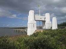
The Hornibrook Bridge was demolished in mid-2011. The only sections remaining are the two iconic entry portals. At the Clontarf end, the original structure has been converted into a walkway and fishing platform. The Ted Smout Memorial Bridge now serves as the pedestrian and bicycle crossing of Bramble Bay.
Heritage listing
The Hornibrook Bridge was listed on the Queensland Heritage Register on 7 October 1994.[3]
See also
References
- 1 2 3 4 5 Redcliffe Historical Society. "Hornibrook Highway Bridge". Retrieved 23 May 2009.
- ↑ Final Curtain for the Hornibrook Highway
- 1 2 3 "Hornibrook Highway Bridge (entry 601246)". Queensland Heritage Register. Queensland Heritage Council. Retrieved 17 July 2015.
External links
![]() Media related to Hornibrook Bridge at Wikimedia Commons
Media related to Hornibrook Bridge at Wikimedia Commons