Randabygda
| Randabygda Hopland | |
|---|---|
| Village | |
|
View of the village | |
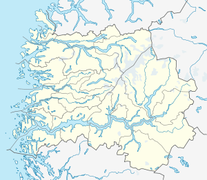 Randabygda  Randabygda Location in Sogn og Fjordane county | |
| Coordinates: 61°52′01″N 06°19′41″E / 61.86694°N 6.32806°ECoordinates: 61°52′01″N 06°19′41″E / 61.86694°N 6.32806°E | |
| Country | Norway |
| Region | Western Norway |
| County | Sogn og Fjordane |
| District | Nordfjord |
| Municipality | Stryn Municipality |
| Elevation[1] | 263 m (863 ft) |
| Time zone | CET (UTC+01:00) |
| • Summer (DST) | CEST (UTC+02:00) |
| Post Code | 6796 Hopland |

Randabygda or Hopland is a village in Stryn Municipality in Sogn og Fjordane county, Norway. The village is located on the northern shore of the Nordfjorden on a rather steep sloping area along the fjord. The village lies about 15 kilometres (9.3 mi) east of the village of Lote (in Eid municipality) and about 15 kilometres (9.3 mi) west of the village of Roset. Randabygda Church is located in this village. The village is divided by the river Hoplandselva, where Hopland lies to the west and Randabygda lies to the east.
References
- ↑ "Randabygda" (in Norwegian). yr.no. Retrieved 2013-10-07.
This article is issued from Wikipedia - version of the 8/1/2016. The text is available under the Creative Commons Attribution/Share Alike but additional terms may apply for the media files.