Hopatcong, New Jersey
| Hopatcong, New Jersey | |
|---|---|
| Borough | |
| Borough of Hopatcong | |
 Map of Hopatcong Borough in Sussex County. | |
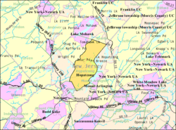 Census Bureau map of Hopatcong, New Jersey | |
| Coordinates: 40°57′09″N 74°39′35″W / 40.952432°N 74.65966°WCoordinates: 40°57′09″N 74°39′35″W / 40.952432°N 74.65966°W[1][2] | |
| Country |
|
| State |
|
| County | Sussex |
| Incorporated | April 2, 1898 as Brooklyn |
| Renamed | March 22, 1901 as Hopatcong |
| Government[3] | |
| • Type | Borough |
| • Body | Borough Council |
| • Mayor | Sylvia Petillo (R, term ends December 31, 2019)[4][5] |
| • Administrator | Robert Elia[6] |
| • Clerk | Catherine Schultz[7] |
| Area[1] | |
| • Total | 12.248 sq mi (31.722 km2) |
| • Land | 10.854 sq mi (28.113 km2) |
| • Water | 1.394 sq mi (3.609 km2) 11.318% |
| Area rank |
188th of 566 in state 16th of 24 in county[1] |
| Elevation[8] | 997 ft (304 m) |
| Population (2010 Census)[9][10][11] | |
| • Total | 15,147 |
| • Estimate (2015)[12] | 14,510 |
| • Rank |
167th of 566 in state 3rd of 24 in county[13] |
| • Density | 1,395.5/sq mi (538.8/km2) |
| • Density rank |
347th of 566 in state 6th of 24 in county[13] |
| Time zone | Eastern (EST) (UTC-5) |
| • Summer (DST) | Eastern (EDT) (UTC-4) |
| ZIP code | 07843[14][15] |
| Area code(s) | 973[16] |
| FIPS code | 3403732910[1][17][18] |
| GNIS feature ID | 0885259[1][19] |
| Website |
www |
Hopatcong /hoʊpætkɑːnɡ/ is a borough in Sussex County, New Jersey, United States. As of the 2010 United States Census, the borough's population was 15,147,[9][10][11] reflecting a decline of 741 (-4.7%) from the 15,888 counted in the 2000 Census, which had in turn increased by 302 (+1.9%) from the 15,586 counted in the 1990 Census.[20]
History
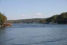
The town of Hopatcong has a rich history, given its relationship with New York City. It borders Lake Hopatcong, a partially man-made lake that is now a source of much recreation and desirable real estate, and is the biggest lake in New Jersey. The community, 40 miles (64 km) west of New York City, began as a summer getaway for the wealthy in NYC who primarily sought access to the lake. An amusement park, called "Bertrand's Island", sprang up and was accessible via the lake, trolley or by car through Mount Arlington. The construction of Interstate 80, a highway that stretches from Teaneck, New Jersey, all the way across the country to San Francisco, California, triggered rapid growth in New York City's suburbs and led to Hopatcong becoming a permanent residential community.
The area had been called "Brookland" in the 19th century and the lake that was expanded to become Lake Hopatcong had been known as "Great Pond" or "Brookland Pond". During the 1830s, the name of the community had been modified to "Brooklyn", to match the spelling of the city on New York's Long Island.[21] Hopatcong was originally established as the Town of Brooklyn on April 2, 1898, from portions of Byram Township. On March 22, 1901, the Borough of Hopatcong replaced Brooklyn.[22] In 1922, residents of Byram Cove, Northwood, and other areas to the west of the original land area of the borough, voted to leave Byram Township and join Hopatcong, leaving the Borough with its current borders.[23]
While the origin of the borough's name is unclear, it is said to derive from Native American phrases variously meaning "stone over water" or "pipestone", among other variations[24][25][26]
Geography
According to the United States Census Bureau, the borough had a total area of 12.248 square miles (31.722 km2), including 10.854 square miles (28.113 km2) of land and 1.394 square miles (3.609 km2) of water (11.38%).[1][2]
Unincorporated communities, localities and place names located partially or completely within the borough include Bear Ponds, Byram Cove, Cow Tongue Point, Davis Cove, Glasser, Hendersons Cove, Lake Hopatcong, Roseville, Sharps Rock and Sperry Springs.[27]
Demographics
| Historical population | |||
|---|---|---|---|
| Census | Pop. | %± | |
| 1900 | 75 | — | |
| 1910 | 146 | 94.7% | |
| 1920 | 179 | 22.6% | |
| 1930 | 534 | 198.3% | |
| 1940 | 660 | 23.6% | |
| 1950 | 1,173 | 77.7% | |
| 1960 | 3,391 | 189.1% | |
| 1970 | 9,052 | 166.9% | |
| 1980 | 15,531 | 71.6% | |
| 1990 | 15,586 | 0.4% | |
| 2000 | 15,888 | 1.9% | |
| 2010 | 15,147 | −4.7% | |
| Est. 2015 | 14,510 | [12][28] | −4.2% |
| Population sources: 1800-1920[29] 1900-1910[30] 1910-1930[31] 1930-1990[32] 2000[33][34] 2010[10] | |||
Census 2010
At the 2010 United States Census, there were 15,147 people, 5,653 households, and 4,110 families residing in the borough. The population density was 1,395.5 per square mile (538.8/km2). There were 6,296 housing units at an average density of 580.0 per square mile (223.9/km2). The racial makeup of the borough was 91.07% (13,794) White, 2.91% (441) Black or African American, 0.11% (16) Native American, 2.25% (341) Asian, 0.02% (3) Pacific Islander, 1.76% (266) from other races, and 1.89% (286) from two or more races. Hispanics or Latinos of any race were 11.32% (1,714) of the population.[9]
There were 5,653 households, of which 31.9% had children under the age of 18 living with them, 58.0% were married couples living together, 9.6% had a female householder with no husband present, and 27.3% were non-families. 21.0% of all households were made up of individuals, and 5.4% had someone living alone who was 65 years of age or older. The average household size was 2.68 and the average family size was 3.13.[9]
In the borough, 22.4% of the population were under the age of 18, 7.9% from 18 to 24, 28.0% from 25 to 44, 32.0% from 45 to 64, and 9.8% who were 65 years of age or older. The median age was 40.2 years. For every 100 females there were 101.0 males. For every 100 females age 18 and over, there were 101.5 males.[9]
The Census Bureau's 2006-2010 American Community Survey showed that (in 2010 inflation-adjusted dollars) median household income was $85,730 (with a margin of error of +/- $4,570) and the median family income was $95,962 (+/- $5,996). Males had a median income of $60,533 (+/- $5,094) versus $47,515 (+/- $7,133) for females. The per capita income for the borough was $36,033 (+/- $2,406). About 1.6% of families and 3.0% of the population were below the poverty line, including 3.8% of those under age 18 and 4.3% of those age 65 or over.[35]
Census 2000
As of the 2000 United States Census[17] there were 15,888 people, 5,656 households, and 4,236 families residing in the borough. The population density was 1,449.7 people per square mile (559.7/km2). There were 6,190 housing units at an average density of 564.8 per square mile (218.1/km2). The racial makeup of the borough was 93.10% White, 1.95% African American, 0.11% Native American, 1.80% Asian, 1.42% from other races, and 1.61% from two or more races. Hispanic or Latino of any race were 5.99% of the population.[33][34]
There were 5,656 households out of which 38.7% had children under the age of 18 living with them, 62.3% were married couples living together, 8.3% had a female householder with no husband present, and 25.1% were non-families. 18.6% of all households were made up of individuals and 4.2% had someone living alone who was 65 years of age or older. The average household size was 2.81 and the average family size was 3.24.[33][34]
In the borough the population was spread out with 26.4% under the age of 18, 7.1% from 18 to 24, 34.8% from 25 to 44, 24.9% from 45 to 64, and 6.8% who were 65 years of age or older. The median age was 36 years. For every 100 females there were 102.0 males. For every 100 females age 18 and over, there were 100.1 males.[33][34]
The median income for a household in the borough was $65,799, and the median income for a family was $73,277. Males had a median income of $47,083 versus $34,238 for females. The per capita income for the borough was $26,698. About 2.2% of families and 3.0% of the population were below the poverty line, including 2.7% of those under age 18 and 5.8% of those age 65 or over.[33][34]
Government
Local government
Hopatcong is governed under the Borough form of New Jersey municipal government. The governing body consists of a Mayor and a Borough Council comprising six council members, with all positions elected at-large on a partisan basis as part of the November general election. A Mayor is elected directly by the voters to a four-year term of office. The Borough Council consists of six members elected to serve three-year terms on a staggered basis, with two seats coming up for election each year in a three-year cycle.[3] The Borough form of government used by Hopatcong, the most common system used in the state, is a "weak mayor / strong council" government in which council members act as the legislative body with the mayor presiding at meetings and voting only in the event of a tie. The mayor can veto ordinances subject to an override by a two-thirds majority vote of the council. The mayor makes committee and liaison assignments for council members, and most appointments are made by the mayor with the advice and consent of the council.[36][37]
As of 2016, the Mayor of Hopatcong Borough is Republican Sylvia Petillo, whose term of office ends December 31, 2019. Members of the Hopatcong Borough Council are Council President Frank Padula (R, 2016; elected to serve an unexpired term), Richard Bunce (R, 2018), Michael Francis (R, 2016), Marie Ryder Galate (R, 2018), Richard Schindelar (R, 2017) and John Young (R, 2017).[4][38][39][40][41]
In May 2014, the Borough Council appointed Frank Padula to fill the vacancy of Richard Hoer, who had resigned the previous month.[42] Padula served on an interim basis until the November 2014 general election, when he ran unopposed and won the balance of the term of office expiring in December 2016.[40][43]
Federal, state and county representation
Hopatcong is located in the 11th Congressional District[44] and is part of New Jersey's 24th state legislative district.[10][45][46] Prior to the 2010 Census, Hopatcong had been part of the 5th Congressional District; the change was made by the New Jersey Redistricting Commission and took effect in January 2013, based on the results of the November 2012 general elections.[47]
New Jersey's Eleventh Congressional District is represented by Rodney Frelinghuysen (R, Harding Township).[48] New Jersey is represented in the United States Senate by Cory Booker (D, Newark, term ends 2021)[49] and Bob Menendez (D, Paramus, 2019).[50][51]
For the 2016–2017 session (Senate, General Assembly), the 24th Legislative District of the New Jersey Legislature is represented in the State Senate by Steve Oroho (R, Franklin) and in the General Assembly by Parker Space (R, Wantage Township) and Gail Phoebus (R, Andover Township).[52] The Governor of New Jersey is Chris Christie (R, Mendham Township).[53] The Lieutenant Governor of New Jersey is Kim Guadagno (R, Monmouth Beach).[54]
Sussex County is governed by a Board of Chosen Freeholders whose five members are elected at-large in partisan elections on a staggered basis, with either one or two seats coming up for election each year. At an annual reorganization meeting held in the beginning of January, the board selects a Freeholder Director and Deputy Director from among its members, with day-to-day supervision of the operation of the county delegated to a County Administrator.[55] As of 2014, Sussex County's Freeholders are Freeholder Director Richard Vohden (R, Green Township, 2016),[56] Deputy Director Dennis J. Mudrick (R, Sparta Township, 2015),[57] Phillip R. Crabb (R, Franklin, 2014),[58] George Graham (R, Stanhope, 2016)[59] and Gail Phoebus (R, Andover Township, 2015).[60][55] Graham was chosen in April 2013 to fill the seat vacated by Parker Space, who had been chosen to fill a vacancy in the New Jersey General Assembly.[61] Constitutional officers elected on a countywide basis are County Clerk Jeff Parrott (R, 2016),[62] Sheriff Michael F. Strada (R, 2016)[63] and Surrogate Gary R. Chiusano (R, filling the vacancy after the resignation of Nancy Fitzgibbons).[64][61] The County Administrator is John Eskilson.[65][66]
Politics
As of March 23, 2011, there were a total of 9,554 registered voters in Hopatcong, of whom 1,917 (20.1% vs. 16.5% countywide) were registered as Democrats, 3,242 (33.9% vs. 39.3%) were registered as Republicans and 4,383 (45.9% vs. 44.1%) were registered as Unaffiliated. There were 12 voters registered to other parties.[67] Among the borough's 2010 Census population, 63.1% (vs. 65.8% in Sussex County) were registered to vote, including 81.3% of those ages 18 and over (vs. 86.5% countywide).[67][68]
In the 2012 presidential election, Republican Mitt Romney received 3,285 votes (55.0% vs. 59.4% countywide), ahead of Democrat Barack Obama with 2,560 votes (42.9% vs. 38.2%) and other candidates with 117 votes (2.0% vs. 2.1%), among the 5,973 ballots cast by the borough's 9,652 registered voters, for a turnout of 61.9% (vs. 68.3% in Sussex County).[69] In the 2008 presidential election, Republican John McCain received 3,941 votes (54.7% vs. 59.2% countywide), ahead of Democrat Barack Obama with 3,096 votes (43.0% vs. 38.7%) and other candidates with 117 votes (1.6% vs. 1.5%), among the 7,199 ballots cast by the borough's 9,571 registered voters, for a turnout of 75.2% (vs. 76.9% in Sussex County).[70] In the 2004 presidential election, Republican George W. Bush received 4,003 votes (59.4% vs. 63.9% countywide), ahead of Democrat John Kerry with 2,616 votes (38.8% vs. 34.4%) and other candidates with 98 votes (1.5% vs. 1.3%), among the 6,739 ballots cast by the borough's 9,182 registered voters, for a turnout of 73.4% (vs. 77.7% in the whole county).[71]
In the 2013 gubernatorial election, Republican Chris Christie received 71.3% of the vote (2,906 cast), ahead of Democrat Barbara Buono with 24.9% (1,016 votes), and other candidates with 3.8% (153 votes), among the 4,110 ballots cast by the borough's 9,777 registered voters (35 ballots were spoiled), for a turnout of 42.0%.[72][73] In the 2009 gubernatorial election, Republican Chris Christie received 3,089 votes (63.2% vs. 63.3% countywide), ahead of Democrat Jon Corzine with 1,260 votes (25.8% vs. 25.7%), Independent Chris Daggett with 441 votes (9.0% vs. 9.1%) and other candidates with 72 votes (1.5% vs. 1.3%), among the 4,888 ballots cast by the borough's 9,454 registered voters, yielding a 51.7% turnout (vs. 52.3% in the county).[74]
Education
Students in public school for Kindergarten through twelfth grade are served by the Hopatcong Public Schools. As of the 2011-12 school year, the district's five schools had an enrollment of 2,020 students and 153.8 classroom teachers (on an FTE basis), for a student–teacher ratio of 13.13:1.[75] Schools in the district (with 2011-12 enrollment data from the National Center for Education Statistics[76]) are Hudson Maxim Elementary School[77] (282 students in KG-1), Tulsa Trail Elementary School[78] (279; 2-3), Durban Avenue Elementary School[79] (302; 4-5), Hopatcong Middle School[80] (483; 6-8) and Hopatcong High School[81] (674; 9-12).[82]
Transportation
As of May 2010, the borough had a total of 78.70 miles (126.66 km) of roadways, of which 65.33 miles (105.14 km) were maintained by the municipality and 13.37 miles (21.52 km) by Sussex County.[83]
Events
Hopatcong holds annual APBA Boat Races that attract the local residents to a day at the lake. Hopatcong is also known for its yearly "Hopatcong Days" that offer a weekend of events that include a parade, and an array of festivities in Modick Park, sponsored by the local Business Association and including an annual Soap Box Derby and Car Show.[84]
The Lake Hopatcong Historical Museum holds a variety of local historical artifacts.[85]
Notable people
People who were born in, residents of, or otherwise closely associated with Hopatcong include:
- Joe Cook (1890–1959), vaudeville actor who lived on the shores of Lake Hopatcong in a house he named "Sleepless Hollow".[86]
- Lotta Crabtree (1847-1924), actress.[23][87]
- Carmen LoPorto (born 1997), child actor.[88]
- Joe Martinek (born 1989), leading football rusher in New Jersey high school history.[89]
- Hudson Maxim (1853–1927), inventor and chemist who is the namesake of the district's Hudson Maxim School.[90]
- Dave Yovanovits (born 1981), former NFL offensive lineman.[91]
References
- 1 2 3 4 5 6 2010 Census Gazetteer Files: New Jersey County Subdivisions, United States Census Bureau. Accessed May 21, 2015.
- 1 2 US Gazetteer files: 2010, 2000, and 1990, United States Census Bureau. Accessed September 4, 2014.
- 1 2 2012 New Jersey Legislative District Data Book, Rutgers University Edward J. Bloustein School of Planning and Public Policy, March 2013, p. 110.
- 1 2 Mayor / Council, Borough of Hopatcong. Accessed August 2, 2016.
- ↑ 2016 New Jersey Mayors Directory, New Jersey Department of Community Affairs. Accessed June 14, 2016.
- ↑ Administrator, Borough of Hopatcong. Accessed August 2, 2016.
- ↑ Borough Clerk, Borough of Hopatcong. Accessed August 2, 2016.
- ↑ U.S. Geological Survey Geographic Names Information System: Borough of Hopatcong, Geographic Names Information System. Accessed March 6, 2013.
- 1 2 3 4 5 DP-1 - Profile of General Population and Housing Characteristics: 2010 for Hopatcong borough, Sussex County, New Jersey, United States Census Bureau. Accessed December 6, 2012.
- 1 2 3 4 Municipalities Grouped by 2011-2020 Legislative Districts, New Jersey Department of State, p. 11. Accessed January 6, 2013.
- 1 2 Profile of General Demographic Characteristics: 2010 for Hopatcong borough, New Jersey Department of Labor and Workforce Development. Accessed December 6, 2012.
- 1 2 PEPANNRES - Annual Estimates of the Resident Population: April 1, 2010 to July 1, 2015 - 2015 Population Estimates for New Jersey municipalities, United States Census Bureau. Accessed May 22, 2016.
- 1 2 GCT-PH1 Population, Housing Units, Area, and Density: 2010 - State -- County Subdivision from the 2010 Census Summary File 1 for New Jersey, United States Census Bureau. Accessed December 6, 2012.
- ↑ Look Up a ZIP Code for Hopatcong, NJ, United States Postal Service. Accessed October 3, 2011.
- ↑ Zip Codes, State of New Jersey. Accessed August 28, 2013.
- ↑ Area Code Lookup - NPA NXX for Hopatcong, NJ, Area-Codes.com. Accessed August 28, 2013.
- 1 2 American FactFinder, United States Census Bureau. Accessed September 4, 2014.
- ↑ A Cure for the Common Codes: New Jersey, Missouri Census Data Center. Accessed October 28, 2012.
- ↑ US Board on Geographic Names, United States Geological Survey. Accessed September 4, 2014.
- ↑ Table 7. Population for the Counties and Municipalities in New Jersey: 1990, 2000 and 2010, New Jersey Department of Labor and Workforce Development, February 2011. Accessed December 6, 2012.
- ↑ Balston, Mottel. A HISTORY OF LANDING, MORRIS COUNTY, NEW JERSEY, LandingNewJersey.com. Accessed May 19, 2008.
- ↑ Snyder, John P. The Story of New Jersey's Civil Boundaries: 1606-1968, Bureau of Geology and Topography; Trenton, New Jersey; 1969. pp. 231 (re Hopatcong) and 229 (re Brooklyn) Accessed October 26, 2012.
- 1 2 History, Borough of Hopatcong. Accessed October 3, 2011.
- ↑ Hutchinson, Viola L. The Origin of New Jersey Place Names, New Jersey Public Library Commission, May 1945. Accessed September 2, 2015.
- ↑ Gannett, Henry. The Origin of Certain Place Names in the United States, p. 138. United States Government Printing Office, 1905. Accessed September 2, 2015.
- ↑ Historical Information, Borough of Hopatcong. Accessed September 2, 2015. "While the origin of the word 'Hopatcong' is unknown, it is believed that the word comes from the Lenape word 'hapakonoesson,' meaning pipestone."
- ↑ Locality Search, State of New Jersey. Accessed May 21, 2015.
- ↑ Census Estimates for New Jersey April 1, 2010 to July 1, 2015, United States Census Bureau. Accessed May 22, 2016.
- ↑ Compendium of censuses 1726-1905: together with the tabulated returns of 1905, New Jersey Department of State, 1906. Accessed October 15, 2013.
- ↑ Thirteenth Census of the United States, 1910: Population by Counties and Minor Civil Divisions, 1910, 1900, 1890, United States Census Bureau, p. 338. Accessed December 6, 2012.
- ↑ Fifteenth Census of the United States : 1930 - Population Volume I, United States Census Bureau, p. 719. Accessed January 23, 2012.
- ↑ Table 6. New Jersey Resident Population by Municipality: 1930 - 1990, New Jersey Department of Labor and Workforce Development. Accessed June 28, 2015.
- 1 2 3 4 5 Census 2000 Profiles of Demographic / Social / Economic / Housing Characteristics for Hopatcong borough, New Jersey, United States Census Bureau. Accessed December 6, 2012.
- 1 2 3 4 5 DP-1: Profile of General Demographic Characteristics: 2000 - Census 2000 Summary File 1 (SF 1) 100-Percent Data for Hopatcong borough, Sussex County, New Jersey, United States Census Bureau. Accessed December 6, 2012.
- ↑ DP03: Selected Economic Characteristics from the 2006-2010 American Community Survey 5-Year Estimates for Hopatcong borough, Sussex County, New Jersey, United States Census Bureau. Accessed November 15, 2012.
- ↑ Cerra, Michael F. "Forms of Government: Everything You've Always Wanted to Know, But Were Afraid to Ask", New Jersey State League of Municipalities. Accessed November 30, 2014.
- ↑ "Forms of Municipal Government in New Jersey", p. 6. Rutgers University Center for Government Studies. Accessed June 3, 2015.
- ↑ 2016 Municipal User Friendly Budget, Borough of Hopatcong. Accessed August 2, 2016.
- ↑ Sussex County General Election November 3, 2015 Summary Report Official Results, Sussex County, New Jersey Clerk, updated November 6, 2015. Accessed August 1, 2016.
- 1 2 Sussex County General Election November 4, 2014 Summary Report Official Results, Sussex County, New Jersey Clerk, updated November 10, 2014. Accessed August 1, 2016.
- ↑ Sussex County General and School Election November 5, 2013 Summary Report Official Results, Sussex County, New Jersey Clerk, updated November 7, 2013. Accessed August 1, 2016.
- ↑ Mayor and Council Meeting Minutes May 21, 2014, Borough of Hopatcong. Accessed August 2, 2016. "Discussion and Appointment of Hopatcong Borough Council Seat VacancyCouncilman Bunce made a motion to approve the appointment of Frank Padula, as recommended by the Hopatcong Republican County Committee, as the Councilman who will replace Richard Hoer."
- ↑ Staff. "Young, Schindelar elected to Hopatcong Council", KWWL (TV), November 5, 2014. Accessed March 31, 2015. "Republican incumbent Frank Padula, who was appointed to fill the council seat vacated by the resignation of Richard Hoer, ran unopposed for a two-year unexpired term."
- ↑ Plan Components Report, New Jersey Redistricting Commission, December 23, 2011. Accessed January 6, 2013.
- ↑ 2016 New Jersey Citizen's Guide to Government, p. 59, New Jersey League of Women Voters. Accessed July 20, 2016.
- ↑ Districts by Number for 2011-2020, New Jersey Legislature. Accessed January 6, 2013.
- ↑ 2011 New Jersey Citizen's Guide to Government, p. 59, New Jersey League of Women Voters. Accessed May 22, 2015.
- ↑ Directory of Representatives: New Jersey, United States House of Representatives. Accessed January 5, 2012.
- ↑ About Cory Booker, United States Senate. Accessed January 26, 2015. "He now owns a home and lives in Newark's Central Ward community."
- ↑ Biography of Bob Menendez, United States Senate, January 26, 2015. "He currently lives in Paramus and has two children, Alicia and Robert."
- ↑ Senators of the 114th Congress from New Jersey. United States Senate. Accessed January 26, 2015. "Booker, Cory A. - (D - NJ) Class II; Menendez, Robert - (D - NJ) Class I"
- ↑ Legislative Roster 2016-2017 Session, New Jersey Legislature. Accessed January 17, 2016.
- ↑ "About the Governor". State of New Jersey. Retrieved 2010-01-21.
- ↑ "About the Lieutenant Governor". State of New Jersey. Retrieved 2010-01-21.
- 1 2 Sussex County Board of Chosen Freeholders, Sussex County, New Jersey. Accessed July 28, 2014.
- ↑ Richard A. Vohden, Sussex County, New Jersey. Accessed July 28, 2014.
- ↑ Dennis J. Mudrick, Sussex County, New Jersey. Accessed July 28, 2014.
- ↑ Phillip R. Crabb, Sussex County, New Jersey. Accessed July 28, 2014.
- ↑ George Graham, Sussex County, New Jersey. Accessed July 28, 2014.
- ↑ Gail Phoebus, Sussex County, New Jersey. Accessed July 28, 2014.
- 1 2 Miller, Jennifer Jean. "George Graham Chosen as Freeholder at Sussex County Republican Convention", TheAlternativePress.com, April 13, 2013. Accessed April 25, 2013. "Graham will fill the freeholder seat that New Jersey Assemblyman Parker Space left to take his new position. Space recently took the seat, which formerly belonged to Gary Chiusano, who in turn, was appointed to the spot of Sussex County Surrogate, following the retirement of Surrogate Nancy Fitzgibbons."
- ↑ Home Page, Sussex County Clerk's Office. Accessed July 28, 2014.
- ↑ Sheriff's Office, Sussex County, New Jersey. Accessed July 28, 2014.
- ↑ Home Page, Sussex County Surrogate. Accessed July 28, 2014.
- ↑ County Administrator, Sussex County, New Jersey. Accessed July 28, 2014.
- ↑ Sussex County Official Directory 2014, Sussex County, New Jersey. Accessed July 28, 2014.
- 1 2 Voter Registration Summary - Sussex, New Jersey Department of State Division of Elections, March 23, 2011. Accessed February 21, 2013.
- ↑ GCT-P7: Selected Age Groups: 2010 - State -- County Subdivision; 2010 Census Summary File 1 for New Jersey, United States Census Bureau. Accessed February 21, 2013.
- ↑ General Election November 6, 2012: District Report - Group Detail, Sussex County, New Jersey Clerk, run date November 30, 2012. Accessed February 26, 2013.
- ↑ 2008 Presidential General Election Results: Sussex County, New Jersey Department of State Division of Elections, December 23, 2008. Accessed February 21, 2013.
- ↑ 2004 Presidential Election: Sussex County, New Jersey Department of State Division of Elections, December 13, 2004. Accessed February 21, 2013.
- ↑ "Governor - Sussex County" (PDF). New Jersey Department of Elections. January 29, 2014. Retrieved December 24, 2014.
- ↑ "Number of Registered Voters and Ballots Cast - November 5, 2013 - General Election Results - Sussex County" (PDF). New Jersey Department of Elections. January 29, 2014. Retrieved December 24, 2014.
- ↑ 2009 Governor: Sussex County, New Jersey Department of State Division of Elections, December 31, 2009. Accessed February 21, 2013.
- ↑ District information for Hopatcong School District, National Center for Education Statistics. Accessed October 3, 2014.
- ↑ School Data for Hopatcong Public Schools, National Center for Education Statistics. Accessed October 3, 2014.
- ↑ Hudson Maxim Elementary School, Hopatcong Public Schools. Accessed October 15, 2013.
- ↑ Tulsa Trail Elementary School, Hopatcong Public Schools. Accessed October 15, 2013.
- ↑ Durban Avenue Elementary School, Hopatcong Public Schools. Accessed October 15, 2013.
- ↑ Hopatcong Middle School, Hopatcong Public Schools. Accessed October 15, 2013.
- ↑ Hopatcong High School, Hopatcong Public Schools. Accessed October 15, 2013.
- ↑ New Jersey School Directory for the Hopatcong Public Schools, New Jersey Department of Education. Accessed October 15, 2013.
- ↑ Sussex County Mileage by Municipality and Jurisdiction, New Jersey Department of Transportation, May 2010. Accessed July 18, 2014.
- ↑ Staff. "Hopatcong Days festivities begin", Daily Record (Morristown), July 12, 2002. Accessed February 21, 2013.
- ↑ Lake Hopatcong Historical Museum, LandingNewJersey.com. Accessed August 4, 2015.
- ↑ History, Borough of Hopatcong. Accessed February 1, 2011. "The center for much of this activity was Joe Cook's Sleepless Hollow in Hopatcong's Davis Cove. Cook was a popular Vaudevillian, comedian and musical theater star who lived at the Lake from 1924 to 1941."
- ↑ Lawson, Anthony. "'Miss Lotta' makes impressive appearance on Lake Hopatcong", Aim Jefferson, September 6, 2013. Accessed October 15, 2013. "The former Southern Belle was re-christened Miss Lotta in honor of one of Lake Hopatcong's most famous summer residents, Lotta Crabtree, an entertainer from the 1800's. In 1885 Lotta's mother had an 18 room summer cottage built in the Breslin Park section of Mount Arlington. She gave it to Lotta and called it Attol Tryst (Lotta spelled backwards)."
- ↑ LoPorto, Lynn. "Carmen LoPorto to air on Showtime's hit series Nurse Jackie", Hopatcong-Sparta Patch, October 5, 2011. Accessed October 4, 2014. "Carmen LoPorto of Hopatcong will be on location shooting an episode for Showtime's hit series Nurse Jackie starring Edie Falco as Jackie Peyton (Nurse Jackie)."
- ↑ Hofmann, Joe. "Off and running", Daily Record (Morristown), September 7, 2006. Accessed February 1, 2011. "Hopatcong's Joe Martinek and Pope John's Jeremy Tucker are both first-team All-State running back candidates who combined for 5,010 yards and 62 touchdowns last year."
- ↑ Via Associated Press. "Hudson Maxim has passed on", Christian Science Monitor, May 7, 1927. Accessed February 1, 2011. "LAKE HOPATCONG, N.J. (AP)-- Hudson Maxim, inventor of explosives and author on a variety of subjects, has passed on at his home here."
- ↑ Hoffman, Joe. "Former Hopatcong star Yovanovits used skill, work ethic to become an NFL draft pick", Daily Record (Morristown), May 3, 2003. Accessed October 3, 2011. "Dave Yovanovits was told to watch for his name to scroll across the bottom of the television screen during the second day of the NFL draft last Sunday. Temple was the only Division 1 school to offer him a scholarship after his senior season at Hopatcong."
External links
| Wikimedia Commons has media related to Hopatcong, New Jersey. |
- Hopatcong Borough website
- Hopatcong Public Schools
- The Township Journal, community newspaper
- Hopatcong Public Schools's 2014–15 School Report Card from the New Jersey Department of Education
- Data for Hopatcong Public Schools, National Center for Education Statistics
Municipalities and communities of Sussex County, New Jersey, United States | ||
|---|---|---|
| Boroughs |  | |
| Town | ||
| Townships | ||
| CDPs | ||
| Other unincorporated communities | ||