Holzberg
| Holzberg | |
|---|---|
 The Holzberg ridge seen from the north | |
| Highest point | |
| Peak | Holzberg |
| Elevation | 444.5 m (1,458 ft) |
| Geography | |
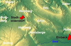 The Holzberg and its neighbouring ranges near Stadtoldendorf | |
| State | Near Stadtoldendorf, Landkreis Holzminden, Niedersachsen (Deutschland) |
| Parent range |
Weser-Leine Uplands; Leine and Weser Uplands |
| Geology | |
| Age of rock | Muschelkalk, bunter sandstone |
| Type of rock | Limestone, sandstone |
The Holzberg is a small range of hills up to 444.5 m above sea level (NN) in south Lower Saxony, Germany.
Geography
The forested ridge of the Holzberg is located in the district of Holzminden at the junction of the Leine Uplands in the east and the Weser Uplands in the west. It lies northeast of the Solling between Stadtoldendorf and the Homburg Forest to the north, the Elfas to the northeast, the Amtsberge to the east, from which it is separate by the small valley of the Teichbach, and Dassel to the southeast. The eastern part of the Holzberg is called the Denkiehausen Forest (Denkiehäuser Wald)
Several streams rise on the Holzberg ridge that, sooner or later, become tributaries of the Leine and Weser. Its northern foothills are drained by the Lenne (an eastern tributary of the Weser) which rises in the area and flows northwest; its eastern slopes by the Teichbach (northern tributary of the Spüligbach); its southern foothills by the upper course of the Spüligbach (northwestern tributary of the Ilme) and its western slopes by the Eberbach (southwestern source stream of the Forstbach).
Hills
The highest elevations on the Holzberg ridge include (in metres above NN):
- Holzberg (444.5 m)
- Klippen (441.3 m)
- Unnamed peak (405.4 m)
- Unnamed peak (436.0 m)
- Unnamed peak (397.0 m)
Streams
The streams of the Holzberg include the:
- Eberbach (southwest source stream of the Forstbach)
- Lenne (eastern tributary of the Weser; rises on the northern edge of the Holzberg)
- Spüligbach (northwestern tributary of the Ilme; rises on the southern edge of the Holzberg)
- Teichbach (northern tributary of the Spüligbach)
Towns and villages
- Dassel - to the southeast
- Deensen - to the west
- Heinade - to the south
- Stadtoldendorf - to the north
- Wangelnstedt - to the northeast
Coordinates: 51°51′N 9°38.5′E / 51.850°N 9.6417°E